
Montant total (1 article articles) :
Destination de la commande :

gilbert johnsons universal cyclopaedia adams (1 résultats)
Passer aux résultats principaux de la recherche
Type d'article
- Tous les types d'articles
- Livres (1)
- Magazines & Périodiques
- Bandes dessinées
- Partitions de musique
- Art, Affiches et Gravures
- Photographies
- Cartes
-
Manuscrits &
Papiers anciens
Etat
- Tous
- Neuf
- Ancien ou d'occasion
Reliure
- Toutes
- Couverture rigide
- Couverture souple
Particularités
- Edition originale
- Signé
- Jaquette
- Avec images
- Sans impression ŕ la demande
Pays
Evaluation du vendeur
-
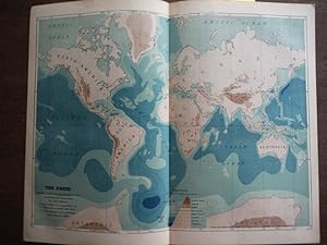
Johnson's Map of the Earth Showing height of land and depth of Sea on the Mercator projection, - Original (1895)
Edité par A. J. Johnson Company, 1895
Vendeur : Imperial Books and Collectibles, Wauwatosa, WI, Etats-Unis
Evaluation du vendeur :

No Binding. Etat : Fine. This rare colored engraved Map of the Earth Showing height of land and depth of Sea on the Mercator projection, drawn and prepared by G. K. Gilbert based chiefly on compilations by J. G. Bartholomew and Henry Gannett, is from Volume II of the 1895 edition the highly acclaimed Johnson's Universal Cyclopaedia. Plate size: 9 1/2" x 12" (24 x 30.5 cm); Condition: Fine; Central fold, as issued. All items carefully packed to avoid damage from moisture and rough handling.