
Montant total (1 article articles) :
Destination de la commande :

homann heirs peter schenck (53 résultats)
Passer aux résultats principaux de la recherche
Type d'article
- Tous les types d'articles
- Livres
- Magazines & Périodiques
- Bandes dessinées
- Partitions de musique
- Art, Affiches et Gravures (53)
- Photographies
- Cartes
-
Manuscrits &
Papiers anciens
Etat
- Tous
- Neuf
- Ancien ou d'occasion
Reliure
- Toutes
- Couverture rigide
- Couverture souple
Particularités
- Edition originale
- Signé
- Jaquette
- Avec images
- Sans impression ŕ la demande
Pays
Evaluation du vendeur
-
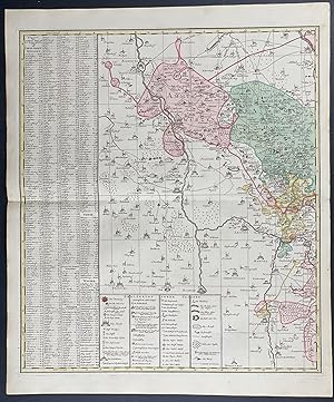
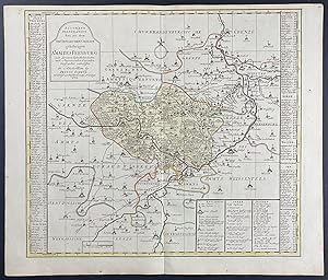
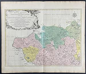
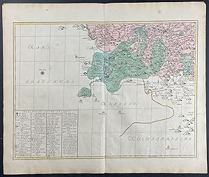
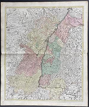
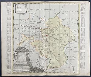
Regional Map of Europe
Edité par Nuremberg, 1750
Vendeur : Trillium Antique Prints & Rare Books, Franklin, TN, Etats-Unis
Evaluation du vendeur :

Art / Affiche / Gravure
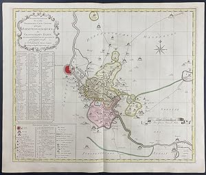
Etat : Fine. This engraving is from a composite atlas presented by the Homann Heirs. Many of the maps in the collection were completed by Peter Schenk or J. B. Homann. The maps were originally published from 1710 to the mid 1800s in Amsterdam and Nuremberg by the Homann Heirs.Following the decline of the great Dutch publishers, the Homann family became one of the most important map publishing houses in Germany. Founded in Nuremberg by Johann Baptist Homann in 1702, the Homann empire dominated Germany's map market for over a century. Homann published his first major atlas in 1707 and was soon after appointed Geographer to the Emperor. After Homann's death in 1724, the firm was continued by his son until 1730. The business was then bequeathed to his heirs with the stipulation that it conducted business under the name of Homann Heirs.The Homann family continued to produce maps until the beginning of the nineteenth century, and remained one of the most important German publishers on the Continent. They published a Neuer Atlas in 1714, a Grosser Atlas in 1737 and an Atlas Maior in 1780. In addition they issued an atlas of German town plans, numerous school atlases, and an atlas of 20 maps of Silesia. Their excellent work had a lasting impact on European maps during the eighteenth century. --- The work is in good to excellent condition overall. There is some faint toning or smudging mostly present in margins. There may be a few minor imperfections or faint marks to be expected with age. There may be some faint bleed through or offset to the fold out plates. Please review the image carefully for condition and contact us with any questions. --- Paper Size ~ 25 1/4" by 21".
-
Regional Map of Europe
Edité par Nuremberg, 1750
Vendeur : Trillium Antique Prints & Rare Books, Franklin, TN, Etats-Unis
Evaluation du vendeur :
Art / Affiche / Gravure
Etat : Fine. This engraving is from a composite atlas presented by the Homann Heirs. Many of the maps in the collection were completed by Peter Schenk or J. B. Homann. The maps were originally published from 1710 to the mid 1800s in Amsterdam and Nuremberg by the Homann Heirs.Following the decline of the great Dutch publishers, the Homann family became one of the most important map publishing houses in Germany. Founded in Nuremberg by Johann Baptist Homann in 1702, the Homann empire dominated Germany's map market for over a century. Homann published his first major atlas in 1707 and was soon after appointed Geographer to the Emperor. After Homann's death in 1724, the firm was continued by his son until 1730. The business was then bequeathed to his heirs with the stipulation that it conducted business under the name of Homann Heirs.The Homann family continued to produce maps until the beginning of the nineteenth century, and remained one of the most important German publishers on the Continent. They published a Neuer Atlas in 1714, a Grosser Atlas in 1737 and an Atlas Maior in 1780. In addition they issued an atlas of German town plans, numerous school atlases, and an atlas of 20 maps of Silesia. Their excellent work had a lasting impact on European maps during the eighteenth century. --- The work is in good to excellent condition overall. There is some faint toning or smudging mostly present in margins. There may be a few minor imperfections or faint marks to be expected with age. There may be some faint bleed through or offset to the fold out plates. Please review the image carefully for condition and contact us with any questions. --- Paper Size ~ 25 1/4" by 21".
-
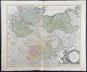
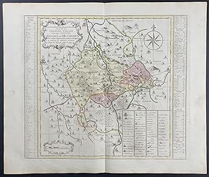
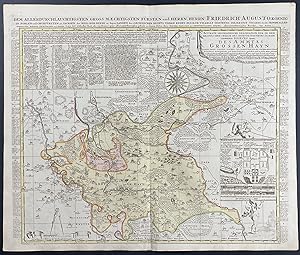
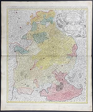
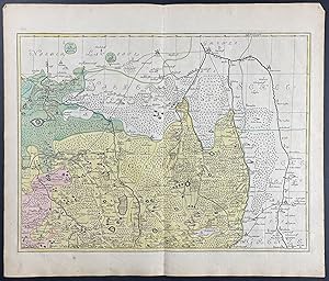
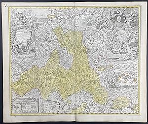
Regional Map of Germany
Edité par Nuremberg, 1750
Vendeur : Trillium Antique Prints & Rare Books, Franklin, TN, Etats-Unis
Evaluation du vendeur :
Art / Affiche / Gravure
Etat : Fine. This engraving is from a composite atlas presented by the Homann Heirs. Many of the maps in the collection were completed by Peter Schenk or J. B. Homann. The maps were originally published from 1710 to the mid 1800s in Amsterdam and Nuremberg by the Homann Heirs.Following the decline of the great Dutch publishers, the Homann family became one of the most important map publishing houses in Germany. Founded in Nuremberg by Johann Baptist Homann in 1702, the Homann empire dominated Germany's map market for over a century. Homann published his first major atlas in 1707 and was soon after appointed Geographer to the Emperor. After Homann's death in 1724, the firm was continued by his son until 1730. The business was then bequeathed to his heirs with the stipulation that it conducted business under the name of Homann Heirs.The Homann family continued to produce maps until the beginning of the nineteenth century, and remained one of the most important German publishers on the Continent. They published a Neuer Atlas in 1714, a Grosser Atlas in 1737 and an Atlas Maior in 1780. In addition they issued an atlas of German town plans, numerous school atlases, and an atlas of 20 maps of Silesia. Their excellent work had a lasting impact on European maps during the eighteenth century. --- The work is in good to excellent condition overall. There is some faint toning or smudging mostly present in margins. There may be a few minor imperfections or faint marks to be expected with age. There may be some faint bleed through or offset to the fold out plates. Please review the image carefully for condition and contact us with any questions. --- Paper Size ~ 25 1/4" by 21".
-
Regional Map of Europe
Edité par Nuremberg, 1750
Vendeur : Trillium Antique Prints & Rare Books, Franklin, TN, Etats-Unis
Evaluation du vendeur :
Art / Affiche / Gravure
Etat : Fine. This engraving is from a composite atlas presented by the Homann Heirs. Many of the maps in the collection were completed by Peter Schenk or J. B. Homann. The maps were originally published from 1710 to the mid 1800s in Amsterdam and Nuremberg by the Homann Heirs.Following the decline of the great Dutch publishers, the Homann family became one of the most important map publishing houses in Germany. Founded in Nuremberg by Johann Baptist Homann in 1702, the Homann empire dominated Germany's map market for over a century. Homann published his first major atlas in 1707 and was soon after appointed Geographer to the Emperor. After Homann's death in 1724, the firm was continued by his son until 1730. The business was then bequeathed to his heirs with the stipulation that it conducted business under the name of Homann Heirs.The Homann family continued to produce maps until the beginning of the nineteenth century, and remained one of the most important German publishers on the Continent. They published a Neuer Atlas in 1714, a Grosser Atlas in 1737 and an Atlas Maior in 1780. In addition they issued an atlas of German town plans, numerous school atlases, and an atlas of 20 maps of Silesia. Their excellent work had a lasting impact on European maps during the eighteenth century. --- The work is in good to excellent condition overall. There is some faint toning or smudging mostly present in margins. There may be a few minor imperfections or faint marks to be expected with age. There may be some faint bleed through or offset to the fold out plates. Please review the image carefully for condition and contact us with any questions. --- Paper Size ~ 25 1/4" by 21".
-
Regional Map of France
Edité par Nuremberg, 1750
Vendeur : Trillium Antique Prints & Rare Books, Franklin, TN, Etats-Unis
Evaluation du vendeur :
Art / Affiche / Gravure
Etat : Fine. This engraving is from a composite atlas presented by the Homann Heirs. Many of the maps in the collection were completed by Peter Schenk or J. B. Homann. The maps were originally published from 1710 to the mid 1800s in Amsterdam and Nuremberg by the Homann Heirs.Following the decline of the great Dutch publishers, the Homann family became one of the most important map publishing houses in Germany. Founded in Nuremberg by Johann Baptist Homann in 1702, the Homann empire dominated Germany's map market for over a century. Homann published his first major atlas in 1707 and was soon after appointed Geographer to the Emperor. After Homann's death in 1724, the firm was continued by his son until 1730. The business was then bequeathed to his heirs with the stipulation that it conducted business under the name of Homann Heirs.The Homann family continued to produce maps until the beginning of the nineteenth century, and remained one of the most important German publishers on the Continent. They published a Neuer Atlas in 1714, a Grosser Atlas in 1737 and an Atlas Maior in 1780. In addition they issued an atlas of German town plans, numerous school atlases, and an atlas of 20 maps of Silesia. Their excellent work had a lasting impact on European maps during the eighteenth century. --- The work is in good to excellent condition overall. There is some faint toning or smudging mostly present in margins. There may be a few minor imperfections or faint marks to be expected with age. There may be some faint bleed through or offset to the fold out plates. Please review the image carefully for condition and contact us with any questions. --- Paper Size ~ 25 1/4" by 21".
-
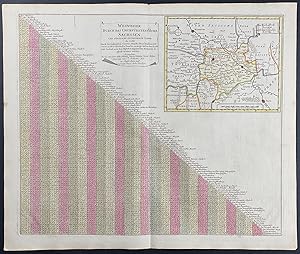
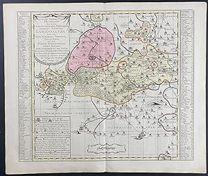
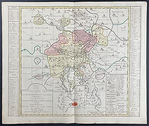
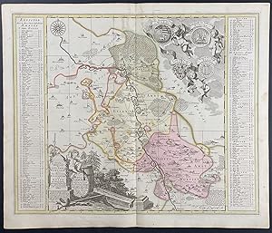
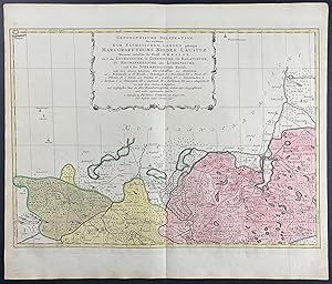
Signposts through the Electoral Principality of Saxony / Wegweiser Durch das Churfurstenthum Sachssen
Edité par Nuremberg, 1750
Vendeur : Trillium Antique Prints & Rare Books, Franklin, TN, Etats-Unis
Evaluation du vendeur :
Art / Affiche / Gravure
Etat : Fine. This engraving is from a composite atlas presented by the Homann Heirs. Many of the maps in the collection were completed by Peter Schenk or J. B. Homann. The maps were originally published from 1710 to the mid 1800s in Amsterdam and Nuremberg by the Homann Heirs.Following the decline of the great Dutch publishers, the Homann family became one of the most important map publishing houses in Germany. Founded in Nuremberg by Johann Baptist Homann in 1702, the Homann empire dominated Germany's map market for over a century. Homann published his first major atlas in 1707 and was soon after appointed Geographer to the Emperor. After Homann's death in 1724, the firm was continued by his son until 1730. The business was then bequeathed to his heirs with the stipulation that it conducted business under the name of Homann Heirs.The Homann family continued to produce maps until the beginning of the nineteenth century, and remained one of the most important German publishers on the Continent. They published a Neuer Atlas in 1714, a Grosser Atlas in 1737 and an Atlas Maior in 1780. In addition they issued an atlas of German town plans, numerous school atlases, and an atlas of 20 maps of Silesia. Their excellent work had a lasting impact on European maps during the eighteenth century. --- The work is in good to excellent condition overall. There is some faint toning or smudging mostly present in margins. There may be a few minor imperfections or faint marks to be expected with age. There may be some faint bleed through or offset to the fold out plates. Please review the image carefully for condition and contact us with any questions. --- Paper Size ~ 25 1/4" by 21".
-

Regional Map of Europe
Edité par Nuremberg, 1750
Vendeur : Trillium Antique Prints & Rare Books, Franklin, TN, Etats-Unis
Evaluation du vendeur :
Art / Affiche / Gravure
Etat : Fine. This engraving is from a composite atlas presented by the Homann Heirs. Many of the maps in the collection were completed by Peter Schenk or J. B. Homann. The maps were originally published from 1710 to the mid 1800s in Amsterdam and Nuremberg by the Homann Heirs.Following the decline of the great Dutch publishers, the Homann family became one of the most important map publishing houses in Germany. Founded in Nuremberg by Johann Baptist Homann in 1702, the Homann empire dominated Germany's map market for over a century. Homann published his first major atlas in 1707 and was soon after appointed Geographer to the Emperor. After Homann's death in 1724, the firm was continued by his son until 1730. The business was then bequeathed to his heirs with the stipulation that it conducted business under the name of Homann Heirs.The Homann family continued to produce maps until the beginning of the nineteenth century, and remained one of the most important German publishers on the Continent. They published a Neuer Atlas in 1714, a Grosser Atlas in 1737 and an Atlas Maior in 1780. In addition they issued an atlas of German town plans, numerous school atlases, and an atlas of 20 maps of Silesia. Their excellent work had a lasting impact on European maps during the eighteenth century. --- The work is in good to excellent condition overall. There is some faint toning or smudging mostly present in margins. There may be a few minor imperfections or faint marks to be expected with age. There may be some faint bleed through or offset to the fold out plates. Please review the image carefully for condition and contact us with any questions. --- Paper Size ~ 25 1/4" by 21".
-
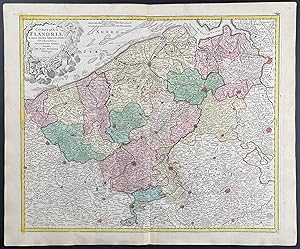
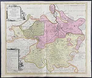
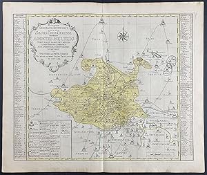
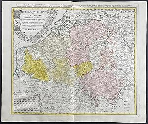
Map of Flanders, Belgium
Edité par Nuremberg, 1750
Vendeur : Trillium Antique Prints & Rare Books, Franklin, TN, Etats-Unis
Evaluation du vendeur :
Art / Affiche / Gravure
Etat : Fine. This engraving is from a composite atlas presented by the Homann Heirs. Many of the maps in the collection were completed by Peter Schenk or J. B. Homann. The maps were originally published from 1710 to the mid 1800s in Amsterdam and Nuremberg by the Homann Heirs.Following the decline of the great Dutch publishers, the Homann family became one of the most important map publishing houses in Germany. Founded in Nuremberg by Johann Baptist Homann in 1702, the Homann empire dominated Germany's map market for over a century. Homann published his first major atlas in 1707 and was soon after appointed Geographer to the Emperor. After Homann's death in 1724, the firm was continued by his son until 1730. The business was then bequeathed to his heirs with the stipulation that it conducted business under the name of Homann Heirs.The Homann family continued to produce maps until the beginning of the nineteenth century, and remained one of the most important German publishers on the Continent. They published a Neuer Atlas in 1714, a Grosser Atlas in 1737 and an Atlas Maior in 1780. In addition they issued an atlas of German town plans, numerous school atlases, and an atlas of 20 maps of Silesia. Their excellent work had a lasting impact on European maps during the eighteenth century. --- The work is in good to excellent condition overall. There is some faint toning or smudging mostly present in margins. There may be a few minor imperfections or faint marks to be expected with age. There may be some faint bleed through or offset to the fold out plates. Please review the image carefully for condition and contact us with any questions. --- Paper Size ~ 25 1/4" by 21".
-
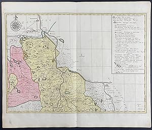
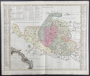
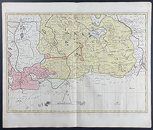
Regional Map of Europe - Leipzig
Edité par Nuremberg, 1750
Vendeur : Trillium Antique Prints & Rare Books, Franklin, TN, Etats-Unis
Evaluation du vendeur :
Art / Affiche / Gravure
Etat : Fine. This engraving is from a composite atlas presented by the Homann Heirs. Many of the maps in the collection were completed by Peter Schenk or J. B. Homann. The maps were originally published from 1710 to the mid 1800s in Amsterdam and Nuremberg by the Homann Heirs.Following the decline of the great Dutch publishers, the Homann family became one of the most important map publishing houses in Germany. Founded in Nuremberg by Johann Baptist Homann in 1702, the Homann empire dominated Germany's map market for over a century. Homann published his first major atlas in 1707 and was soon after appointed Geographer to the Emperor. After Homann's death in 1724, the firm was continued by his son until 1730. The business was then bequeathed to his heirs with the stipulation that it conducted business under the name of Homann Heirs.The Homann family continued to produce maps until the beginning of the nineteenth century, and remained one of the most important German publishers on the Continent. They published a Neuer Atlas in 1714, a Grosser Atlas in 1737 and an Atlas Maior in 1780. In addition they issued an atlas of German town plans, numerous school atlases, and an atlas of 20 maps of Silesia. Their excellent work had a lasting impact on European maps during the eighteenth century. --- The work is in good to excellent condition overall. There is some faint toning or smudging mostly present in margins. There may be a few minor imperfections or faint marks to be expected with age. There may be some faint bleed through or offset to the fold out plates. Please review the image carefully for condition and contact us with any questions. --- Paper Size ~ 25 1/4" by 21".
-
Regional Map of Europe
Edité par Nuremberg, 1750
Vendeur : Trillium Antique Prints & Rare Books, Franklin, TN, Etats-Unis
Evaluation du vendeur :
Art / Affiche / Gravure
Etat : Fine. This engraving is from a composite atlas presented by the Homann Heirs. Many of the maps in the collection were completed by Peter Schenk or J. B. Homann. The maps were originally published from 1710 to the mid 1800s in Amsterdam and Nuremberg by the Homann Heirs.Following the decline of the great Dutch publishers, the Homann family became one of the most important map publishing houses in Germany. Founded in Nuremberg by Johann Baptist Homann in 1702, the Homann empire dominated Germany's map market for over a century. Homann published his first major atlas in 1707 and was soon after appointed Geographer to the Emperor. After Homann's death in 1724, the firm was continued by his son until 1730. The business was then bequeathed to his heirs with the stipulation that it conducted business under the name of Homann Heirs.The Homann family continued to produce maps until the beginning of the nineteenth century, and remained one of the most important German publishers on the Continent. They published a Neuer Atlas in 1714, a Grosser Atlas in 1737 and an Atlas Maior in 1780. In addition they issued an atlas of German town plans, numerous school atlases, and an atlas of 20 maps of Silesia. Their excellent work had a lasting impact on European maps during the eighteenth century. --- The work is in good to excellent condition overall. There is some faint toning or smudging mostly present in margins. There may be a few minor imperfections or faint marks to be expected with age. There may be some faint bleed through or offset to the fold out plates. Please review the image carefully for condition and contact us with any questions. --- Paper Size ~ 25 1/4" by 21".
-
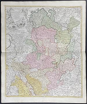
Regional Map of Germany
Edité par Nuremberg, 1750
Vendeur : Trillium Antique Prints & Rare Books, Franklin, TN, Etats-Unis
Evaluation du vendeur :
Art / Affiche / Gravure
Etat : Fine. This engraving is from a composite atlas presented by the Homann Heirs. Many of the maps in the collection were completed by Peter Schenk or J. B. Homann. The maps were originally published from 1710 to the mid 1800s in Amsterdam and Nuremberg by the Homann Heirs.Following the decline of the great Dutch publishers, the Homann family became one of the most important map publishing houses in Germany. Founded in Nuremberg by Johann Baptist Homann in 1702, the Homann empire dominated Germany's map market for over a century. Homann published his first major atlas in 1707 and was soon after appointed Geographer to the Emperor. After Homann's death in 1724, the firm was continued by his son until 1730. The business was then bequeathed to his heirs with the stipulation that it conducted business under the name of Homann Heirs.The Homann family continued to produce maps until the beginning of the nineteenth century, and remained one of the most important German publishers on the Continent. They published a Neuer Atlas in 1714, a Grosser Atlas in 1737 and an Atlas Maior in 1780. In addition they issued an atlas of German town plans, numerous school atlases, and an atlas of 20 maps of Silesia. Their excellent work had a lasting impact on European maps during the eighteenth century. --- The work is in good to excellent condition overall. There is some faint toning or smudging mostly present in margins. There may be a few minor imperfections or faint marks to be expected with age. There may be some faint bleed through or offset to the fold out plates. Please review the image carefully for condition and contact us with any questions. --- Paper Size ~ 25 1/4" by 21".
-
Regional Map of Europe
Edité par Nuremberg, 1750
Vendeur : Trillium Antique Prints & Rare Books, Franklin, TN, Etats-Unis
Evaluation du vendeur :
Art / Affiche / Gravure
Etat : Fine. This engraving is from a composite atlas presented by the Homann Heirs. Many of the maps in the collection were completed by Peter Schenk or J. B. Homann. The maps were originally published from 1710 to the mid 1800s in Amsterdam and Nuremberg by the Homann Heirs.Following the decline of the great Dutch publishers, the Homann family became one of the most important map publishing houses in Germany. Founded in Nuremberg by Johann Baptist Homann in 1702, the Homann empire dominated Germany's map market for over a century. Homann published his first major atlas in 1707 and was soon after appointed Geographer to the Emperor. After Homann's death in 1724, the firm was continued by his son until 1730. The business was then bequeathed to his heirs with the stipulation that it conducted business under the name of Homann Heirs.The Homann family continued to produce maps until the beginning of the nineteenth century, and remained one of the most important German publishers on the Continent. They published a Neuer Atlas in 1714, a Grosser Atlas in 1737 and an Atlas Maior in 1780. In addition they issued an atlas of German town plans, numerous school atlases, and an atlas of 20 maps of Silesia. Their excellent work had a lasting impact on European maps during the eighteenth century. --- The work is in good to excellent condition overall. There is some faint toning or smudging mostly present in margins. There may be a few minor imperfections or faint marks to be expected with age. There may be some faint bleed through or offset to the fold out plates. Please review the image carefully for condition and contact us with any questions. --- Paper Size ~ 25 1/4" by 21".
-
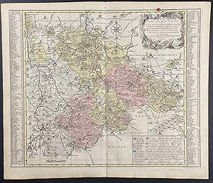
Regional Map of Belgium
Edité par Nuremberg, 1750
Vendeur : Trillium Antique Prints & Rare Books, Franklin, TN, Etats-Unis
Evaluation du vendeur :
Art / Affiche / Gravure
Etat : Fine. This engraving is from a composite atlas presented by the Homann Heirs. Many of the maps in the collection were completed by Peter Schenk or J. B. Homann. The maps were originally published from 1710 to the mid 1800s in Amsterdam and Nuremberg by the Homann Heirs.Following the decline of the great Dutch publishers, the Homann family became one of the most important map publishing houses in Germany. Founded in Nuremberg by Johann Baptist Homann in 1702, the Homann empire dominated Germany's map market for over a century. Homann published his first major atlas in 1707 and was soon after appointed Geographer to the Emperor. After Homann's death in 1724, the firm was continued by his son until 1730. The business was then bequeathed to his heirs with the stipulation that it conducted business under the name of Homann Heirs.The Homann family continued to produce maps until the beginning of the nineteenth century, and remained one of the most important German publishers on the Continent. They published a Neuer Atlas in 1714, a Grosser Atlas in 1737 and an Atlas Maior in 1780. In addition they issued an atlas of German town plans, numerous school atlases, and an atlas of 20 maps of Silesia. Their excellent work had a lasting impact on European maps during the eighteenth century. --- The work is in good to excellent condition overall. There is some faint toning or smudging mostly present in margins. There may be a few minor imperfections or faint marks to be expected with age. There may be some faint bleed through or offset to the fold out plates. Please review the image carefully for condition and contact us with any questions. --- Paper Size ~ 25 1/4" by 21".
-
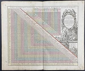
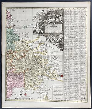
Mileage Charts between German & European Towns / Tabula Poliometrica Germaniae ac Praecipuorum Quorundam Locorum Europae
Edité par Nuremberg, 1750
Vendeur : Trillium Antique Prints & Rare Books, Franklin, TN, Etats-Unis
Evaluation du vendeur :
Art / Affiche / Gravure
Etat : Fine. This engraving is from a composite atlas presented by the Homann Heirs. Many of the maps in the collection were completed by Peter Schenk or J. B. Homann. The maps were originally published from 1710 to the mid 1800s in Amsterdam and Nuremberg by the Homann Heirs.Following the decline of the great Dutch publishers, the Homann family became one of the most important map publishing houses in Germany. Founded in Nuremberg by Johann Baptist Homann in 1702, the Homann empire dominated Germany's map market for over a century. Homann published his first major atlas in 1707 and was soon after appointed Geographer to the Emperor. After Homann's death in 1724, the firm was continued by his son until 1730. The business was then bequeathed to his heirs with the stipulation that it conducted business under the name of Homann Heirs.The Homann family continued to produce maps until the beginning of the nineteenth century, and remained one of the most important German publishers on the Continent. They published a Neuer Atlas in 1714, a Grosser Atlas in 1737 and an Atlas Maior in 1780. In addition they issued an atlas of German town plans, numerous school atlases, and an atlas of 20 maps of Silesia. Their excellent work had a lasting impact on European maps during the eighteenth century. --- The work is in good to excellent condition overall. There is some faint toning or smudging mostly present in margins. There may be a few minor imperfections or faint marks to be expected with age. There may be some faint bleed through or offset to the fold out plates. Please review the image carefully for condition and contact us with any questions. --- Paper Size ~ 25 1/4" by 21".
-
Regional Map of Europe
Edité par Nuremberg, 1750
Vendeur : Trillium Antique Prints & Rare Books, Franklin, TN, Etats-Unis
Evaluation du vendeur :
Art / Affiche / Gravure
Etat : Fine. This engraving is from a composite atlas presented by the Homann Heirs. Many of the maps in the collection were completed by Peter Schenk or J. B. Homann. The maps were originally published from 1710 to the mid 1800s in Amsterdam and Nuremberg by the Homann Heirs.Following the decline of the great Dutch publishers, the Homann family became one of the most important map publishing houses in Germany. Founded in Nuremberg by Johann Baptist Homann in 1702, the Homann empire dominated Germany's map market for over a century. Homann published his first major atlas in 1707 and was soon after appointed Geographer to the Emperor. After Homann's death in 1724, the firm was continued by his son until 1730. The business was then bequeathed to his heirs with the stipulation that it conducted business under the name of Homann Heirs.The Homann family continued to produce maps until the beginning of the nineteenth century, and remained one of the most important German publishers on the Continent. They published a Neuer Atlas in 1714, a Grosser Atlas in 1737 and an Atlas Maior in 1780. In addition they issued an atlas of German town plans, numerous school atlases, and an atlas of 20 maps of Silesia. Their excellent work had a lasting impact on European maps during the eighteenth century. --- The work is in good to excellent condition overall. There is some faint toning or smudging mostly present in margins. There may be a few minor imperfections or faint marks to be expected with age. There may be some faint bleed through or offset to the fold out plates. Please review the image carefully for condition and contact us with any questions. --- Paper Size ~ 25 1/4" by 21".