Montant total (1 article articles) :
Destination de la commande :

hondius henricus (110 résultats)
Passer aux résultats principaux de la recherche
Type d'article
- Tous les types d'articles
- Livres (36)
- Magazines & Périodiques
- Bandes dessinées
- Partitions de musique
- Art, Affiches et Gravures (23)
- Photographies (1)
- Cartes (50)
-
Manuscrits &
Papiers anciens
Etat
- Tous
- Neuf
- Ancien ou d'occasion
Reliure
Particularités
- Edition originale (4)
- Signé (1)
- Jaquette
- Avec images (90)
- Sans impression ŕ la demande
Pays
Evaluation du vendeur
-
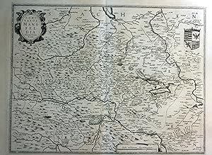
![Image du vendeur pour Landkarte von Lothringen, Südlothringen (Lotharingia Meridiona.[lis]), Frankreich. mis en vente par Antiquariat Hieronymus](https://pictures.abebooks.com/inventory/md/md31348267749.jpg)
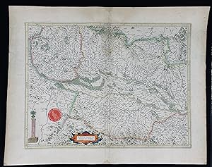
Landkarte von Lothringen, Südlothringen (Lotharingia Meridiona.[lis]), Frankreich.
Edité par Johannes Janssonius, Amsterdam, 1607
Carte
Etat : Gut. Gut. Kupferstich, altkoloriert. Blattgröße: 16,7 x 23,6 cm, Druckspiegel: 14,7 x 18,8 cm. . Kräftiger und guter Druck auf leicht gebräuntem Papier, insgesamt gut erhalten. Schöne kleine Landkarte des südlichen Lothringen ("Lotharingia meridiona.[lis]"), zwischen Maas und Vogesen mit dem oberen Lauf der Mosel bis Nancy, aus: "Atlas Minor", Amsterdam 1607. Landkarte, map, carte géographique, carta geografica, France, Frankreich, Francia, Lothringen, Lorraine, Lorena. 400 Gramm.
-
![Image du vendeur pour [Portfolio]: Antique Maps of the World in Color mis en vente par Between the Covers-Rare Books, Inc. ABAA](https://pictures.abebooks.com/inventory/md/md31614799540.jpg)
[Portfolio]: Antique Maps of the World in Color
Edité par Sterling Publishing House, Co., Inc, New York, 1960
Vendeur : Between the Covers-Rare Books, Inc. ABAA, Gloucester City, NJ, Etats-Unis
Membre d'association : ABAA ESA ILAB IOBA
Evaluation du vendeur :

Edition originale
Unbound. Etat : Very Good. Portfolio. Color facsimiles of 36 historical maps. Each map measures approximately 12" x 9", printed on 17" x 11˝" paper with descriptive text in the left margin. Housed with a title page sheet and unprinted top sheet in a four-fold chemise. Unprinted topsheet sunned at the edges, first two leaves with some very light toning and a couple of tiny corner creases; the maps are otherwise bright and fine. The chemise is good only with toning, wear, and soil, and a 1" creased tear on the cover panel. A nice production, and the chemise has done its job, keeping the maps bright and fresh.
-
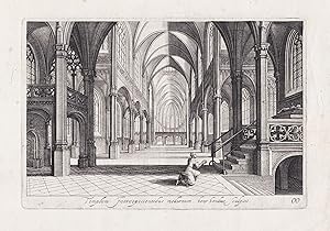
Templum Introspicientibus modernum" / Inside view of a church with a woman praying
Edité par Amsterdam ca. 1640., 1640
Vendeur : Antiquariat Steffen Völkel GmbH, Seubersdorf, Allemagne
Membre d'association : ILAB VDA
Evaluation du vendeur :
Art / Affiche / Gravure
Original Kupferstich von ca. 1640.-- Blatt-Maße: ca. 29,5 x 39 cm. -- mit alt hinterlegtem Randeinriss, sonst gut erhalten. || Original copper engraving from c. 1640. -- with a deposited marginal tear, otherwise in good condition. la Gewicht in Gramm: 15.
-
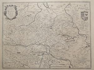
Comitatus Mansfeldia" - Mansfeld Aschersleben Walkenried Karte map
Date d'édition : 1630
Vendeur : Antiquariat Steffen Völkel GmbH, Seubersdorf, Allemagne
Membre d'association : ILAB VDA
Evaluation du vendeur :
Art / Affiche / Gravure
original Kupferstich-Karte von ca. 1630 - Blatt-Format: ca. 57,5 x 42 cm - mit kleinem Rostfleck, sonst gut erhalten. | original copper engraved map from about 1630 - with small rust stain, otherwise in good condition. | Original! - Kein Nachdruck! - Keine Kopie! | This is an original! - No reprint! - No copy! Sprache: Deutsch Gewicht in Gramm: 1500.
-

Etat : -. Gefaltete alt-kolorierte Kupferstich-Karte. Blattmaß: 61 x 47 cm. Mit kleinem Riss im unterem Rand. Alterbedingt leicht gebräunt. Fotos gerne auf Anfrage.
-
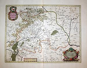
Principatus Hennenbergensis." - Grafschaft Henneberg Schmalkalden Franken Karte map
Edité par Amsterdam, Janssonius um 1680., 1680
Vendeur : Antiquariat Steffen Völkel GmbH, Seubersdorf, Allemagne
Membre d'association : ILAB VDA
Evaluation du vendeur :
Carte
Original altkolorierte Kupferstich-Karte. Gutes Exemplar in seltenem Original-Verlagskolorit. -- Ohne Rückentext. -- Blatt-Maße: ca. 60 x 50,5 cm. -- gut erhalten. || Original old colored engraved map. In very good condition, with the rare original publishing coloring. Without text on verso. -- in good condition.|| Dies ist ein Original! - Kein Nachdruck! - Keine Kopie! -- This is an original! No copy! - No reprint! la Gewicht in Gramm: 1550.
-
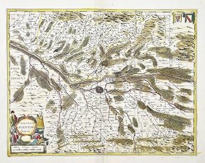
Territorium Argentoratense." - Strassburg Strasbourg carte Rhein Karte map
Edité par (Amsterdam, Hondius) um 1680., 1680
Vendeur : Antiquariat Steffen Völkel GmbH, Seubersdorf, Allemagne
Membre d'association : ILAB VDA
Evaluation du vendeur :
Carte
Original altkolorierte Kupferstich-Karte. Gutes Exemplar in seltenem Original-Verlagskolorit. -- Ohne Rückentext. -- Blatt-Maße: ca. 50 x 62 cm. -- mit mehreren hinterlegten Farbbrüchen (ohne Verlust), sonst gut erhalten. || Original old colored engraved map. In very good condition with the rare original publishing coloring. Without text on verso. -- with several small restorations (without any loss of image), otherwise in good condition. la Gewicht in Gramm: 35.
-
Institut cartogr fic de Catalunya, Barcelona, 2006, edici n facsimil, NĽ47 de la tirada de 200 ejemplares, ilustrado con gr ficos en color + un mapa a color desplegable, encuadernaci n tela editorial con estuche, 21pg., 37*25,5cm., 1350gr.
-
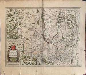
Comitatus Mansfeldia. (Grafschaft Mansfeld) Kupferstichkarte von H. Hondius. Plattengrösse 38 x 50,5 cm.
Edité par um, 1630
Vendeur : Antiquariat im Schloss, Schwaigern, D, Allemagne
Evaluation du vendeur :
Carte
Gebiet zwischen Aschersleben im Norden, Rinderbruck im Süden sowie Walkenried im Westen und Rockendorff im Osten. Minimal angebräunt. Sprache: Deutsch Gewicht in Gramm: 900.
-
Landkarte von Aragon / Aragonien (Aragonia), Spanien.
Edité par Johannes Janssonius, Amsterdam, 1648
Carte
Etat : Gut. Gut. Kupferstich auf Passepartout montiert, altkoloriert. Blattgröße: 18,5 x 22 cm, Druckspiegel: 20,5 x 15,5 cm. . Kräftiger und klarer Druck auf leicht gebräuntem Papier, auf Passepartout montiert, insgesamt gut erhalten. Sehr schöne und seltene Landkarte von Aragon, aus der deutschen Ausgabe: "Atlas Minor. Das ist: Eine kurze jedoch gründliche Beschreibung der ganzen Welt, in zwey Theile abgetheilt", Bd. 1, Amsterdam 1648. Landkarte, map, carte géographique, carta geografica, Spanien, Nordspanien, Spain, Espagnia, Espana, Spagna, Espagne, Arragon. 1200 Gramm.
-
Etat : Gut. Gut. Kupferstich auf Passepartout montiert, altkoloriert. Blattgröße: 18,5 x 23 cm, Druckspiegel: 20,5 x 16 cm. . Kräftiger und klarer Druck auf leicht gebräuntem Papier, auf Passepartout montiert, insgesamt gut erhalten. Sehr schöne und seltene Landkarte von Navarra, aus der deutschen Ausgabe: "Atlas Minor. Das ist: Eine kurze jedoch gründliche Beschreibung der ganzen Welt, in zwey Theile abgetheilt", Bd. 1, Amsterdam 1648. Landkarte, map, carte géographique, carta geografica, Spanien, Nordspanien, Spain, Espagnia, Espana, Spagna, Espagne, Navarre, Navarra. 1200 Gramm.
-
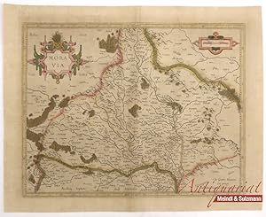
Moravia".
Edité par Amsterdam, Hondius, 1627., 1627
Vendeur : Antiquariat MEINDL & SULZMANN OG, Wien - Vienna, Autriche
Evaluation du vendeur :
Blattgröße ca. 39,5 x 49 cm. Bildausschnitt ca. 33 x 42,5 cm (Mittelfalz geglättet. Papier gebräunt und etw. braunfleckig). Henricus Hondius II., auch Hendrik Hondius der Jüngere (1597- 1651) war der Sohn des berühmten Kartographen Jodocus Hondius, der in Amsterdam ein kartographisches Unternehmen gegründet hatte. Nachdem Hendrik zunächst im elterlichen Betrieb mitgearbeitet hatte, gründete er 1621 in seiner Heimatstadt einen eigenen Verlag. 1633 ging Henricus eine Partnerschaft mit dem Kartographen und seinem Schwager Johannes Janssonius ein, und gemeinsam führten sie das Geschäft weiter.- Rückseite mit lateinischem Text: "Moravia Marchionatus Marhern Germanis . Nomen habet ŕ fluvio Morava.".- Im unteren Teil der Karte (Süden) auch Teile des Weinviertels mit einigen Ortschaften eingezeichnet, wie z.B.: Mailberg, Pulkau, Schrattenthal, Retz, Staatz, Mistelbach, Herrenbaumgarten, Falkenstein, Wildendürnbach, Poysdorf etc. Graphik - Landkarten.
-
Landkarte des Elsass (Breisgau, Sundgau, Schwarzwald), Frankreich.
Edité par Selbstverlag, Amsterdam, 1623
Carte
Etat : Gut. Gut. Kupferstich, altkoloriert. Blattgröße: 45 x 57 cm, Druckspiegel: 36,3 x 47,8 cm. . Kräftiger und klarer Druck auf etwas, im Falz und am Rand stärker gebräuntem Papier, kleine Randläsuren, insgesamt gut erhalten. Schöne große Landkarte des Elsass mit dem Breisgau, Sundgau ("Alsatia superior cum Suntgoia et Brisgoia"), Schwarzwald bis Basel, Schweiz - nach Westen hin orientiert, aus: "Atlas sive Cosmographicae Meditationes de Fabrica Mundi et Fabricati Figura", Amsterdam 1623 Landkarte, map, carte géographique, carta geografica, France, Frankreich, Francia, Alsace, Alsazia, Alsace, Black Forrest, Foresta Negra, Foret-Noire. 1800 Gramm.
-
Nova Alemaniae sive Sveviae Superioris Tabula." - Schwaben Bodensee Karte map
Edité par Amsterdam, (Hondius?) um 1650., 1650
Vendeur : Antiquariat Steffen Völkel GmbH, Seubersdorf, Allemagne
Membre d'association : ILAB VDA
Evaluation du vendeur :
Carte
Original altkolorierte Kupferstich-Karte. Gutes Exemplar in seltenem Original-Verlagskolorit. -- Ohne Rückentext. -- Blatt-Maße: ca. 60 x 50,5 cm. -- gut erhalten. || Original old colored engraved map. In very good condition with the rare original publishing coloring. Without text on verso. -- in good condition.|| Dies ist ein Original! - Kein Nachdruck! - Keine Kopie! -- This is an original! No copy! - No reprint! la Gewicht in Gramm: 1550.
-
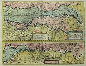
Etat : mäßiger Zustand. Niederrhein. Rheinlauf von Rheinberg bis Gorinchem. Hondius. Descriptio Fluminum Rheni, Vahalis et Mosae a Rheno Berca ad Goricomium usque, comprehendens Imperium Noviomagense, Bataviam, Tielae et Bomelij insulas, regionesque conterminas.1642. Kupferstich, alt koloriert. Landkarte, von Henricus Hondius. 37,5 x 49,2 cm (Darstellung), 46 x 57 cm (Blatt).Aus: Johannes Janssonius, Newer Atlas. Das ist Weltbeschreibung Und Volkommene Abbildung Aller unterschiedlichen Koenigreiche, Länder und Provintzen Sampt Ost- und West-Indien, davon gnugsam und volkommener bericht zufinden (Amsterdam: Hondius / Janssonius 1642). Zeigt den Lauf des Rheins von Rheinberg (nördlich von Duisburg) bis Gorinchem, Rhenen und Culenborg (südlich von Utrecht). Bugfalte mittig angeschmutzt. Rand unten rechts hinterlegt. Insgesamt leicht gebräunt und angeschmutzt. Verso niederländischer Text. Mäßig guter Zustand.Henricus Hondius (1597 Amsterdam - 1651 Amsterdam). Niederländischer Kupferstecher, Kartograf und Verleger, Sohn des Jodocus Hondius. Zunächst Mitarbeit im väterlichen Betrieb. 1621 Gründung eines eigenen Verlags. Sein Vater kaufte 1604 die Platten von Mercators Weltatlas und veröffentlichete 1606 den Mercator-Hondius-Atlas mit etwa 40 neuen Karten. 1641 gab Henricus Hondius eine neue Auflage des Mercator-Hondius-Atlas mit veränderten Hondius-Karten heraus. Obere Teilkarte links unten mit Titelkartusche. Mittig Kartusche mit 2 Maßstäben / Meilenzeiger und Windrose sowie Verlegeradresse AMSTELODAMI / Excusum apud Henricum Hondium habitans supra damum sub insigno Atlantis. Untere Teilkarte mittig mit 2 Maßstäben / Meilenzeigern und rechts oben Windrose.
-
Tartaria
Edité par Amsterdam,, 1632
Vendeur : libreria antiquaria perini Sas di Perini, Verona, VR, Italie
Membre d'association : ALAI ILAB
Evaluation du vendeur :
Art / Affiche / Gravure
Incisione in rame, colorata, 190x260. Decorativa mappa della Russia asiatica, Mongolia, Tartaria fino allo stretto di Bering. Raffigura anche la muraglia cinese. Nr.cat: 100_6911.
-
Alsatia superior cu Suntgoia & Brisgoia
Date d'édition : 1630
Vendeur : Kunstantiquariat Andreas Senger, Hamburg, Allemagne
Evaluation du vendeur :
Carte
Kein Einband. Etat : Gut. Es handelt sich hierbei um eine originale, altkolorierte Kupferstich-Landkarte des Elsass und des Breisgaus von Henricus Hondius (1597 - 1651) aus dem Jahr 1630. *** Titel: Alsatia superior cu Suntgoia & Brisgoia *** Gebiet bzw. Ort: Elsaß, Breisgau, Sundgau *** Kartograph: Henricus Hondius (1597 - 1651) *** Jahr: 1630 *** Größe des Plattenbereichs: 36 x 47 cm *** Technik: Kupferstich *** Zustand (Perfekt/ Sehr gut/ Gut/ Ordentlich/ Mäßig/ Schlecht): In gutem Erhaltungszustand *** Bemerkungen: Die altkolorierte Karte zeigt das Breisgau, Sundgau und den Schwarzwald mit dem Rhein zwischen Basel und Straßburg - - - International buyers welcome. If you have any questions, please don't hesitate to ask. - - - ----- Auf Wunsch stellen wir Ihnen gerne ein kostenfreies Echtheitszertifikat aus ------ If you wish, we will gladly provide a certificate of authenticity free of charge ---.
-
![Image du vendeur pour Austria Archiducatus auctore Wolfgango Lazio [Archdiocese of Austria] mis en vente par Antiqua Print Gallery](https://pictures.abebooks.com/inventory/md/md31683071131.jpg)
Etat : Good. Austria Archiducatus auctore Wolfgango Lazio by Henricus Hondius c1636 old map. Original 17th century antique atlas map with old hand colouring; Henricus Hondius (c1636). 37.5 x 54.5cm, 14.75 x 21.5 inches. Condition: Good. The map has been laid down onto board. Please contact us if you would like to arrange to view this map. The map has been laid down onto board.
-

Fossa Eugeniana quae a Rheno ad Mosam duci coepta est
Edité par Schenk, Peter & Valck, Gerard, Amsterdam, 1710
Vendeur : Antikvariat Krenek, Prag, Rébublique tchčque
Membre d'association : ILAB
Evaluation du vendeur :
Carte
Kein Einband. Etat : Gut bis sehr gut. Fossa Eugeniana. "Fossa Eugeniana quae a Rheno ad Mosam duci coepta est". Altkol. Kupferstich Karte von H. Hondius, dat. 1627. Bei P. Schenk & G. Valck, um 1710. Mit 3 ornament. Kart. 36,5:48,5 cm. Niederrhein-Karte in der Begrenzung Xanten-Wesel-Kempen-Venlo mit dem nie fertiggestellten Kanal im Zentrum.
-
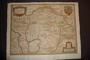
Nassovia comitatus.
Edité par Amsterdam, ca. 1630., 1630
Vendeur : Antiquariaat Garcia, Mechelen, Belgique
Membre d'association : ILAB
Evaluation du vendeur :

Large in-folio. Nice original copper -engraving . Old colouring. Good copy of this map of the Nassau region. 3 cartouches.
-
Territory Basiliensis Nova Descriptio
Edité par [Amsterdam: Jansson, c.1640]., 1640
Vendeur : William Matthews/The Haunted Bookshop, Sidney, BC, Canada
Membre d'association : ABAC ILAB
Evaluation du vendeur :

Copper-engraved map on laid paper, hand-coloured cartouches in lower left corner. Hand-colouring to entire map. Text on the verso in French, heading titled: Le Territoire de BASLE. Hand-coloured initial on verso. Signature mark on verso is IIi. Plate size is 49cm x 38cm, on a sheet measuring 55cm x 48.5cm. Old yellowed tape repair on verso at fold and edges, some splitting at fold, pin holes to margins, tears in lower margin, very good condition. Probably from the French edition of Jansson's "Nouveau Theatre du Monde ou Nouvel Atlas" [c.1640]. Numbered in pencil at upper right with the numeral "67". From WorldCat's description: "The first French editions of the Atlas Novus appeared in three volumes in 1639, a year after the inaugural Latin version. The promptness with which the translation was readied meant that these were largely identical to the Latin original in material and structure, although several revisions were made to the order of contents to better tailor Jansson's offering to the Francophone market: thus, the French part of the Atlas was given new precedence over the Dutch one, and the Spanish and Portuguese chapters were detached from the French section in order to give the latter a stronger thematic coherence than it had previously had. Despite these similarities, the publication of the French editions was quite different from the Latin. After issuing the latter together, by 1639 Jansson and Hondius had resolved to print their own copies of the French title under their own imprints, and this division of resources and duplication of editions has resulted in a distinct, more complex publishing history. Indeed, variations in the stock of plates available to the former partners resulted in two quite separate classes of Atlas, with as many as twenty-five different maps between them, Jansson's typically the more up to date. Matters are further complicated by both Jansson and Hondius' habit of regularly updating their imprints for several years from 1639 onwards, resulting in confusing arrays of dates across the volumes of a single set.".
-
Belgian Flanders
Edité par Henricus Hondius, Amsterdam, 1630
Vendeur : Antikvariat Krenek, Prag, Rébublique tchčque
Membre d'association : ILAB
Evaluation du vendeur :
Carte
Kein Einband. Etat : Sehr gut. Belgian Flanders. "Habes hic Novam & accuratissimam descriptionem tractus illius Flandriae per que superioribus .". Orig. copperplate engraving, H. Hondius in Amsterdam, 1630. Engraved by P. Kaerius. With ornamental title-cartouche. 37:51,5 cm (14 1/2 x 20 1/4 inch.). Koeman I, map 3205:1, ed. 1:107 (1630 Latin). - A m ap of the eastern part of Belgian (West) Flanders with the cities of Ghent, Bruges, Ostend and others. - Nice, darkt impression. P rinted on paper sized 47,5:56,5 cm.
-
Antique Map-BRABANTIAE-BRABANT-BREDA-BIESBOSCH-Hondius-c.1640
Edité par c.1640, 1640
Vendeur : Pictura Prints, Art & Books, Overasselt, Pays-Bas
Membre d'association : ILAB NVVA
Evaluation du vendeur :
'BRABANTIAE PARS SEPTENTRIONALIS CONTINENS MARCHIONATUS S.ROM. IMPERIJ. BERGOZOMARUM. COMITATUS ( )'This print shows a map called Brabantić pars septentrionalis, the west of province of Brabant in the Netherlands. At the bottom right is a title cartouche with scale bar and compass rose. The city of Breda (Baronie Breda) is in the center of the map. In the north Hoekse Waard-Dordrecht-Bommelerwaard, Biesbosch. In the east 's-Hertogenbosch-Oirschot and the Brabantse Kempen. In the south Antwerp-Herentals and in the west Heenvliet-Tholen-Hulst. On the reverse Dutch text about the marquisate of Bergen op Zoom.Made by after an anonymous artist.Medium: Engraving / original handcoloured on hand laid (verge) paper.Sheet size: 66.2 x 55.6 cm (26.06 x 21.89 inch). Image size: 55 x 46.5 cm. (21.65 x 18.31 inch).MAP-BRABANTIAE-BRABANT-BREDA-DEN BOSCH-BIESBOSCH-NETHERLANDS-BERGEN OP ZOOM-ANTWERP | RB-T.29-LARGEBACKGROUND INFORMATIONThis attractive print was first published in 1633. This one is probably a later edition.Biography engraver: Henricus Hondius also: Hendrik or Henri (Amsterdam, 1597 16 August 1651) is one of the most important Dutch cartographers. Condition: good, given age. Fold as published. Two small tears in fold restored. Map backed: thin Japanese paper glued to the reverse. Folds and creases in margins. General age-related toning and/or occasional minor defects from handling. Please study scan carefully.
-
Comitatus Wertheimici Finitimarumque Regionum Nova Et Exacta Descriptio.
Edité par Amsterdam: Jansson, [c.1640]., 1640
Vendeur : William Matthews/The Haunted Bookshop, Sidney, BC, Canada
Membre d'association : ABAC ILAB
Evaluation du vendeur :
Copper-engraved map on laid paper, hand-coloured cartouche in upper right. Hand-colouring to entire map. Imprint at lower margin: "Joannes Janssonius execudit". Text on the verso in French, heading titled Le Comte De WERTHAIM. Hand-coloured initial on verso. Signature mark on verso is YY. Plate size is 50.5cm x 39cm, on a sheet measuring 58cm x 50cm. Old tape repairs to central fold and a few short tears on verso, very good condition. From Volume III of the French edition of Jansson's "Nouveau Theatre du Monde ou Nouvel Atlas" [c.1640]. Numbered in pencil at upper right with the numeral "57". From WorldCat's description: "The first French editions of the Atlas Novus appeared in three volumes in 1639, a year after the inaugural Latin version. The promptness with which the translation was readied meant that these were largely identical to the Latin original in material and structure, although several revisions were made to the order of contents to better tailor Jansson's offering to the Francophone market: thus, the French part of the Atlas was given new precedence over the Dutch one, and the Spanish and Portuguese chapters were detached from the French section in order to give the latter a stronger thematic coherence than it had previously had. Despite these similarities, the publication of the French editions was quite different from the Latin. After issuing the latter together, by 1639 Jansson and Hondius had resolved to print their own copies of the French title under their own imprints, and this division of resources and duplication of editions has resulted in a distinct, more complex publishing history. Indeed, variations in the stock of plates available to the former partners resulted in two quite separate classes of Atlas, with as many as twenty-five different maps between them, Jansson's typically the more up to date. Matters are further complicated by both Jansson and Hondius' habit of regularly updating their imprints for several years from 1639 onwards, resulting in confusing arrays of dates across the volumes of a single set.".
-
Stiria Vulgo Steyrmarck
Edité par [Amsterdam: Jansson, c.1640]., 1640
Vendeur : William Matthews/The Haunted Bookshop, Sidney, BC, Canada
Membre d'association : ABAC ILAB
Evaluation du vendeur :
Copper-engraved map on laid paper, hand-coloured cartouches in upper right & lower left corners. Hand-colouring to entire map. Text on the verso in French, heading titled: Description Du Duche de STIRIE. Hand-coloured initial and tailpiece on verso. Signature mark on verso is HHHh. Plate size is 51cm x 38.5cm, on a sheet measuring 58cm x 49.5cm. Old yellowed tape repair on verso at fold and edges, some splitting at fold, chipping at lower fold, pin holes to margins, very good condition. Probably from the French edition of Jansson's "Nouveau Theatre du Monde ou Nouvel Atlas" [c.1640]. Numbered in pencil at upper right with the numeral "90". From WorldCat's description: "The first French editions of the Atlas Novus appeared in three volumes in 1639, a year after the inaugural Latin version. The promptness with which the translation was readied meant that these were largely identical to the Latin original in material and structure, although several revisions were made to the order of contents to better tailor Jansson's offering to the Francophone market: thus, the French part of the Atlas was given new precedence over the Dutch one, and the Spanish and Portuguese chapters were detached from the French section in order to give the latter a stronger thematic coherence than it had previously had. Despite these similarities, the publication of the French editions was quite different from the Latin. After issuing the latter together, by 1639 Jansson and Hondius had resolved to print their own copies of the French title under their own imprints, and this division of resources and duplication of editions has resulted in a distinct, more complex publishing history. Indeed, variations in the stock of plates available to the former partners resulted in two quite separate classes of Atlas, with as many as twenty-five different maps between them, Jansson's typically the more up to date. Matters are further complicated by both Jansson and Hondius' habit of regularly updating their imprints for several years from 1639 onwards, resulting in confusing arrays of dates across the volumes of a single set." A map of Styria in Austria, based on Blaeu's map of 1635.
-
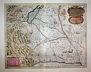
Nova Alemanniae sive Sueviae superioris Tabula
Date d'édition : 1640
Vendeur : Kunstantiquariat Andreas Senger, Hamburg, Allemagne
Evaluation du vendeur :
Carte
Kein Einband. Etat : Gut. Es handelt sich hierbei um eine originale, kolorierte Kupferstichlandkarte des Gebiets zwischen Lech und Donau von J. Janssonius bei H. Hondius, um das Jahr 1640. *** Titel: Nova Alemanniae sive Sueviae superioris Tabula *** Ort: Westorientierte Karte des Gebietes zwischen Lech und Donau, mit dem Bodensee und dem Allgäu. Zeigt auch Liechtenstein. *** Kartograph: Johann Janssonius (1588 - 1664) / Henricus Hondius (1597 - 1651) *** Jahr: ca. 1640 *** Größe des Plattenbereichs: 38 x 49 cm *** Technik: Kupferstich *** Zustand (Perfekt/ Sehr gut/ Gut/ Ordentlich/ Mäßig/ Schlecht): In gutem Erhaltungszustand *** Bemerkungen: Bugfalte im unteren Bereich hinterlegt. Untere Ecken mit leichten Knickspuren. - - - International buyers welcome. If you have any questions, please don't hesitate to ask. - - - ----- Auf Wunsch stellen wir Ihnen gerne ein kostenfreies Echtheitszertifikat aus ------ If you wish, we will gladly provide a certificate of authenticity free of charge ---.
-
Sclavonia, Croatia, Bosnia cum Dalmatiae Parte
Date d'édition : 1639
Vendeur : Kunstantiquariat Andreas Senger, Hamburg, Allemagne
Evaluation du vendeur :
Carte
Kein Einband. Etat : Gut. Es handelt sich hierbei um eine originale, kolorierte Kupferstich-Landkarte des Balkans von Henricus Hondius (1597 - 1651) - Mercator aus dem Jahr 1639. *** Titel: Sclavonia, Croatia, Bosnia cum Dalmatiae Parte *** Gebiet bzw. Ort: Balkan *** Kartograph: Henricus Hondius (1597 - 1651) - Mercator *** Jahr: 1639 *** Größe des Plattenbereichs: 36 x 46 cm *** Technik: Kupferstich *** Zustand (Perfekt/ Sehr gut/ Gut/ Ordentlich/ Mäßig/ Schlecht): In gutem Erhaltungszustand *** Bemerkungen: Mittelfalte fachgerecht mit Japanpapier hinterlegt - - - International buyers welcome. If you have any questions, please don't hesitate to ask. --- Auf Wunsch stellen wir Ihnen gerne ein kostenfreies Echtheitszertifikat aus --- If you wish, we will gladly provide a certificate of authenticity free of charge ---.
-
Guaiana fiue Amazonum regio.
Vendeur : Librero Anticuario Armando Vites, Rosario, ., Argentine
Membre d'association : ALADA
Evaluation du vendeur :
Livre
Encuadernación de tapa blanda. Etat : Bien. Amsterdam 1636? Blanco y negro. 50 x 41 cms.
-
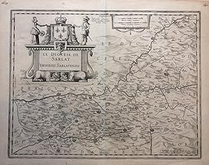
Le Diocese de Sarlat Diocoesis Sarlatensis
Edité par Henrici Hondius, Amsterdam, 1625
Vendeur : Argosy Book Store, ABAA, ILAB, New York, NY, Etats-Unis
Membre d'association : ABAA ILAB
Evaluation du vendeur :
unbound. Etat : very good. Map. Uncolored engraving. Image measures 14.5 x 19 inches, sheet measures 16.5 x 21.25 inches. Shows some light foxing. In very good condition. Early map of the Dordogne region of southwestern France known for it's red wine production of Cabernet Sauvignon, Merlot, and Bordeaux. Handsome lions with man faces grace the giant title cartouche. Unusual collaboration between Hondius and Tavernier. Jodocus Hondius (1563-1612) was the founder of a prolific map publishing business, which helped to propel the Dutch to lead innovations in cartography. When Jodocus the elder died in 1612, his wife Colette ran the business until their sons came of age to join the firm. During this time, their daughter Elisabeth married Johannes Jansson and the two of them helped Colette run the business. Jodocus & Colette's youngest son, Henricus Hondius (1597-1651) later ran the business along with his extended family. Joannes Tardo (1561-1636), was the Canon of Sarlat, a mathematician and map editor. Melchior Tavernier (1564-1641), was an engraver and map seller in Paris.
-
![Image du vendeur pour Utriusque Castiliae Nova Descriptio [Mapa original de Castilla, Espańa] mis en vente par Bolivar Old Prints Anticuario](https://pictures.abebooks.com/inventory/md/md31742328568.jpg)
Utriusque Castiliae Nova Descriptio [Mapa original de Castilla, Espańa]
Edité par Ámsterdam, 1636
Vendeur : Bolivar Old Prints Anticuario, Barcelona, BARCE, Espagne
Membre d'association : AILA
Evaluation du vendeur :
Carte
Etat : Good. Muy decorativo mapa de Castilla que comprende Extremadura, Castilla la Nueva, Ávila, Salamanca y parte de Burgos, Logrońo, Palencia, Aragón, Valencia, Jaén, Madrid, Córdoba, Sevilla, Granada, Murcia, entre otros. Fue publicado en Ámsterdam en la obra Nouveau Theatre du Monde ou Nouvel Atlas comprenant Les Tables et Descriptions de toutes les Regions de la Terre. Contiene muchos elementos interesantes como la cartela del título ornamentada y coronada por un orbe, los escudos de Castilla y del antiguo reino de Toledo, una leyenda con ubicación de episcopados y universidades y una pequeńa cartela decorada con la escala. Abundante toponimia en castellano y latín, y orografía de perfil. Henricus Hondius (1597-1651) fue un cartógrafo y grabador holandés, miembro de una prominente familia de cartógrafos. Mientras trabajó con su padre, el famoso Jodocus Hondius, jugó un papel fundamental en la reedición del atlas de Mercator, publicado por primera vez en 1595. A la muerte de su padre en 1612, Henricus y su hermano, Jodocus el Joven, continuaron con el negocio familiar. Estableció su primera tienda en 1621 y más adelante se asoció con su cuńado, Jan Janssonius, otro afamado cartógrafo, con quien continuó expandiendo y publicando el atlas de Mercator, mismo que terminó conociéndose como el atlas Mercator-Hondius-Janssonius. Murió en 1651. 41 x 50 cm. 5413 Map Carte Utriusque Castiliae Nova Descriptio Ámsterdam Hondius, Henricus 1636 Good 320 ?.