
Montant total (1 article articles) :
Destination de la commande :

jaillot after sanson (5 rťsultats)
Passer aux rťsultats principaux de la recherche
Type d'article
- Tous les types d'articles
- Livres
- Magazines & Pťriodiques
- Bandes dessinťes
- Partitions de musique
- Art, Affiches et Gravures
- Photographies
- Cartes (5)
-
Manuscrits &
Papiers anciens
Etat
- Tous
- Neuf
- Ancien ou d'occasion
Reliure
- Toutes
- Couverture rigide (1)
- Couverture souple
Particularitťs
- Edition originale (1)
- Signť
- Jaquette
- Avec images
- Sans impression ŗ la demande
Pays
Evaluation du vendeur
-
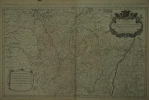
La Lorraine, qui comprend Les Duchťs de Lorraine et de Bar et les Balliages des Eveschťs et des Villes de Metz, Toul, et Verdun.
Editť par Paris:, 1690
Vendeur : Robert Frew Ltd. ABA ILAB, London, Royaume-Uni
Membre d'association : ABA ILAB PBFA
Evaluation du vendeur :

Carte
54 x 87.5 cm. Double page copper engraved map of Lorraine. Original outline colour. Large decorative cartouche to upper right corner. Horizontal crease parallel and adjacent to centrefold, otherwise good.
-

La Flandre FranÁoise, .
Editť par ParisJaillot., 1689
Vendeur : Robert Frew Ltd. ABA ILAB, London, Royaume-Uni
Membre d'association : ABA ILAB PBFA
Evaluation du vendeur :
Carte
43.1 x 57 cm. Original outline colour. Single page folio map of southern Flanders and Artois. Blank on verso. Small tear without loss at upper edge just touching image. Small section of upper margin missing though not affecting map. Small brown spot to centre of lower edge.
-
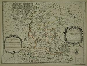
Le Limbourg ou sont Le Duche De Limbourg Le Comtť De Dalem; Les Seigneuries De Fauquemont, Et De Rolduc .
Editť par ParisJaillot., 1681
Vendeur : Robert Frew Ltd. ABA ILAB, London, Royaume-Uni
Membre d'association : ABA ILAB PBFA
Evaluation du vendeur :
Carte
43 x 57 cm. Original outline colour. Single page folio map of Limborg and its envirions. Blank on verso. Small tear with loss to upper right margin. Some light stains at right margin though not affecting image, otherwise in very good condition.
-
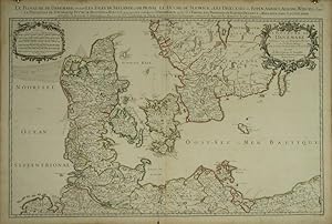
Le Royaume De Danemark SubdivisŤ en ses Principales Provinces, Tire de Plusieurs Memoires.
Editť par ParisJaillot., 1685
Vendeur : Robert Frew Ltd. ABA ILAB, London, Royaume-Uni
Membre d'association : ABA ILAB PBFA
Evaluation du vendeur :
Carte
54.6 x 88.4 cm. Original outline colour. Large double page map of Denmark. Blank on verso. Minor creasing to left of centrefold, otherwise in very good condition.
-
![Image du vendeur pour [Normandy] Le Duchť et Gouvernement de Normandie divisťe en Haute et Basse Normandie en divers Pays; et par evÍchez, avec le Gouvernement General du Havre de Grace mis en vente par Donald A. Heald Rare Books (ABAA)](https://pictures.abebooks.com/inventory/md/md22471027642.jpg)
[Normandy] Le Duchť et Gouvernement de Normandie divisťe en Haute et Basse Normandie en divers Pays; et par evÍchez, avec le Gouvernement General du Havre de Grace
Editť par Alexis Hubert Jaillot, Paris, 1696
Vendeur : Donald A. Heald Rare Books (ABAA), New York, NY, Etats-Unis
Membre d'association : ABAA ILAB
Evaluation du vendeur :
Carte Edition originale
Copper-engraved map, with full original colour and gold embellishment, in excellent condition. A stunning map of Normandy by Alexis Jaillot, an exceptional example with gilt embellishments. One of the most important figures in French cartography, Nicolas Sanson initiated the great school of French geographers. Born in Abbeville in 1600, Sanson established his first printing house in Paris in 1638. He soon became geographer to the king, establishing himself as one of the most influential cartographers on the Continent. He was succeeded by his sons, Adrien and Guillaume, and by his son-in-law Pierre Duval, who continued to publish a wealth of maps using Sanson's name. At the close of the seventeenth century, Sanson's plates were purchased by the influential cartographer Alexis Hubert Jaillot, who continued to publish his maps and atlases under Sanson's title. This stunning map of Normandy is based on Sanson's map published in 1650, but was redrawn and enlarged by Jaillot. It shows the provinces of Normandy as well as the northern tip of Brittany and part of the English Channel. Both Jersey and Guernsey are included as is Mont St. Michel off the coast of St. Malo. In keeping with all of Sanson's and Jaillot's superb maps, forests, rivers, and towns are meticulously identified and named. The map includes an ornate cartouche in the upper section as well as a scale and key. Tooley, Maps & Map-Makers, pp. 40-41.