Montant total (1 article articles) :
Destination de la commande :

keulen johannes 1654 1715 (38 résultats)
Passer aux résultats principaux de la recherche
Type d'article
- Tous les types d'articles
- Livres (22)
- Magazines & Périodiques
- Bandes dessinées
- Partitions de musique
- Art, Affiches et Gravures (1)
- Photographies
- Cartes (15)
-
Manuscrits &
Papiers anciens
Etat
- Tous
- Neuf
- Ancien ou d'occasion
Reliure
- Toutes
- Couverture rigide (15)
- Couverture souple
Particularités
- Edition originale
- Signé
- Jaquette
- Avec images
- Sans impression ŕ la demande
Pays
Evaluation du vendeur
-
White Sea/Kola, map anno 1715, J. van Keulen
Edité par Keulen Johannes van 1654-1715, 1715
Vendeur : Hammelburger Antiquariat, Hammelburg, Allemagne
Evaluation du vendeur :

Hardcover. Etat : very good. White Sea/Kola, map anno 1715, J. van Keulen Coppermap, edited by J. van Keulen, anno 1715, "Paskaart van de Mont van de WITTE ZEE.", size of the leaf: 53x60 cm., minor cracs on margins, little brownish.
-
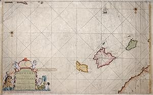
Paskaart, voor een Gedeelte der Kust van, Barbaria, van C. Ivi, tot Bona. En de Kust van, Catalonia.Eylanden, Yvica, Majorca, en Minorca
Edité par Artist: Keulen Johannes van ( - 1715 ) Amsterdam ; issued in: Amsterdam ; ca: 1750; - Johannes van Keulen (1654 - 1715) was a 17th-century Dutch cartographer He published the influential nautical atlas the Zee-Atlas and the pilot guide Zee-Fakkel In 1678 Johannes van Keulen established himself in Amsterdam and in 1680 he obtained a patent from the States of Holland and West Friesland allowing him to print and publish maritime atlases and shipping guides These were books of maps and descriptions of itineraries used by helmsmen for safe navigation The patent was a kind of protection against illegal copying of produced books and charts This was especially important for the atlases which were made with extensive initial costs Van Keulen named h, 1654
Vendeur : Antique Sommer& Sapunaru KG, München, Allemagne
Membre d'association : ILAB VDA
Evaluation du vendeur :
Technic: Copper print; colorit: colored; condition: Upper and lower margin cutted, missing part!, size (in cm): 36 x 58; - Part of the map from van Keulen of the coast of Catalonia, Majorca, Minorca, Ibiza and part of the Barbary coast.; - Special feature: De Nieuwe Groote Lichtende Zee-Fackel.
-
Scotland/Westcoast, anno 1712, J. van Keulen map, coloured
Edité par Keulen Johannes van 1654-1715, 1712
Vendeur : Hammelburger Antiquariat, Hammelburg, Allemagne
Evaluation du vendeur :
Carte
Kein Einband. Etat : Befriedigend. Copperengraving, edited by J. van Keulen "Pascaert vande westkust van SCHOTLANT, als mede een gedeelte van de Lewys Eylanden, van S. Patricius.", coloured, size: 505x564 mm., some minor cracs on margins, Amsterdam, anno 1712.
-
Mer du Nord Europe. England, Hull, anno 1715, Van Keulen map-scarce
Edité par Keulen Johannes van 1654-1715, 1715
Vendeur : Hammelburger Antiquariat, Hammelburg, Allemagne
Evaluation du vendeur :
Carte
Kein Einband. Etat : Befriedigend. East-England/anno 1715, map, van Keulen Coppermap, edited by J. van Keulen, anno 1715, "Pas-caert Vande Zee-custen van ENGELAND.", old colours, some cracs on margins, more on below margin, size of the leaf: 52x59 cm.
-
Jutland/North Frisian Islands, anno 1715, Van Keulen, map
Edité par Keulen Johannes van 1654-1715, 1715
Vendeur : Hammelburger Antiquariat, Hammelburg, Allemagne
Evaluation du vendeur :
Hardcover. Etat : very good. "Paskaart vande West Kust van Jutland Van Busem tot aent Jutsche Riff." Seekarte veröffentlicht bei Van Keulen, anno 1715, mit der Westküste von Schleswig-Holstein und Dänemark mit den Nordfriesischen Inseln. Blattmaß: 53x60 cm., guter Erhaltungszustand.
-
Channel/Dover/Calais, anno 1715 J.van Keulen map
Edité par Keulen Johannes van 1654-1715, 1715
Vendeur : Hammelburger Antiquariat, Hammelburg, Allemagne
Evaluation du vendeur :
Hardcover. Etat : very good. Channel/Dover/Calais, anno 1715 J.van Keulen map Channel/Dover/Calais, anno 1715 J.van Keulen map Coppermap, edited by J. van Keulen, anno 1715, printed on thick paper, good image, wide margins, size of the leaf: 62x74 cm.
-

Cust van Hispangien"
Edité par Artist: Keulen Johannes van ( - 1715 ) Amsterdam ; issued in: Amsterdam ; ca: 1680; - Johannes van Keulen (1654 - 1715) was a 17th-century Dutch cartographer He published the influential nautical atlas the Zee-Atlas and the pilot guide Zee-Fakkel In 1678 Johannes van Keulen established himself in Amsterdam and in 1680 he obtained a patent from the States of Holland and West Friesland allowing him to print and publish maritime atlases and shipping guides These were books of maps and descriptions of itineraries used by helmsmen for safe navigation The patent was a kind of protection against illegal copying of produced books and charts This was especially important for the atlases which were made with extensive initial costs Van Keulen named h, 1654
Vendeur : Antique Sommer& Sapunaru KG, München, Allemagne
Membre d'association : ILAB VDA
Evaluation du vendeur :
Carte
Technic: Copper print; colorit: colored; condition: Very good, size (in cm): 39 x 52; - chart of the Strait of Gibraltar.
-
Galconda Orixa Bengal
Edité par Artist: Keulen Johannes van ( - 1715 ) Amsterdam ; issued in: Amsterdam ; ca: 1690; - Johannes van Keulen (1654 - 1715) was a 17th-century Dutch cartographer He published the influential nautical atlas the Zee-Atlas and the pilot guide Zee-Fakkel In 1678 Johannes van Keulen established himself in Amsterdam and in 1680 he obtained a patent from the States of Holland and West Friesland allowing him to print and publish maritime atlases and shipping guides These were books of maps and descriptions of itineraries used by helmsmen for safe navigation The patent was a kind of protection against illegal copying of produced books and charts This was especially important for the atlases which were made with extensive initial costs Van Keulen named h, 1654
Vendeur : Antique Sommer& Sapunaru KG, München, Allemagne
Membre d'association : ILAB VDA
Evaluation du vendeur :
Technic: Copper print; colorit: original colored; condition: Tear on upper margin perfectly restored, size (in cm): 44,5 x 56; - Map depicts the south eastern coast of India with the source of the river Ganges.
-
Sussex/South England, map, van Keulen anno 1715
Edité par Keulen Johannes van 1654-1715, 1715
Vendeur : Hammelburger Antiquariat, Hammelburg, Allemagne
Evaluation du vendeur :
Hardcover. Etat : very good. Coppermap, edited by J. van Keulen, approx. anno 1715, published in Amsterdam, printed on thick paper, no cracs, very good condition. Size of the leaf: 61x74 cm.
-
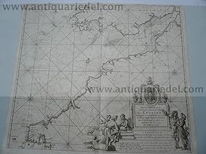
Cornwall, map anno 1715, van Keulen
Edité par Keulen Johannes van 1654-1715, 1715
Vendeur : Hammelburger Antiquariat, Hammelburg, Allemagne
Evaluation du vendeur :
Art / Affiche / Gravure
Hardcover. Etat : Gut. Cornwall, map anno 1715, van Keulen Coppermap, edited anno 1715, by van Keulen, size of the leaf: 61x74 cm., some restorations on margins, little brownish.
-
Cape Verde, anno 1715, map van Keulen
Edité par Keulen Johannes van 1654-1715, 1715
Vendeur : Hammelburger Antiquariat, Hammelburg, Allemagne
Evaluation du vendeur :
Hardcover. Etat : very good. Coppermap, edited by J. van Keulen, anno 1715, good print, printed on thick paper, small brown crac in the map (1x1mm, easy to restore),Coppermap, edited by J. van Keulen, anno 1715, "Pas-caert Vande Zee-custen van ENGELAND.", old colours, some cracs on margins, more on below margin, size of the leaf: 52x59 cm. size of the leaf: 54x60 cm.
-
Nieuwe Wassende Gradige Pas-kaart van een gedeelte der Zee-kust
Edité par Keulen Johannes van 1654-1715, 1715
Vendeur : Hammelburger Antiquariat, Hammelburg, Allemagne
Evaluation du vendeur :
Hardcover. Etat : very good. Nieuwe Wassende Gradige Pas-kaart van een gedeelte der Zee-kust van Normandie, Vimeux en Ponthieu, strekkende van Etaples tot Sotte Ville G. van Keulen. Amsterdam. Edition circa. anno 1740, size of the sheet: 52x60 cm., contemporary colours.
-
Nouvelle CARTE MARINE croissante en degrés d'une partie des Côte
Edité par Keulen Johannes van 1654-1715, 1715
Vendeur : Hammelburger Antiquariat, Hammelburg, Allemagne
Evaluation du vendeur :
Hardcover. Etat : very good. Nouvelle CARTE MARINE croissante en degrés d'une partie des Côtes Maritimes de NORMANDIE contenant soit les Côtes de COTENTIN et BESSIN en tirant depuis BEREE jusqu'ŕ CHERBOURG avec leur profondeur et Bancs de sable". A Amsterdam, par G. VAN KEULEN. Carte gravée. Coloris ancien. Size of the sheet: 52x60 cm., old colours, good condition.
-
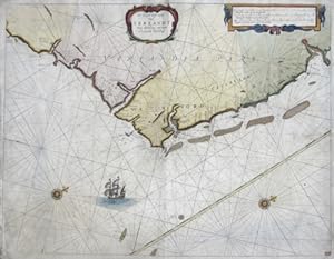
De Zuyd Oost zyde van Yerlandt van Dubing tot aen t Eylandt Corkbeg
Edité par Artist: Keulen Johannes van ( - 1715 ) Amsterdam ; issued in: Amsterdam ; ca: 1700; - Johannes van Keulen (1654 - 1715) was a 17th-century Dutch cartographer He published the influential nautical atlas the Zee-Atlas and the pilot guide Zee-Fakkel In 1678 Johannes van Keulen established himself in Amsterdam and in 1680 he obtained a patent from the States of Holland and West Friesland allowing him to print and publish maritime atlases and shipping guides These were books of maps and descriptions of itineraries used by helmsmen for safe navigation The patent was a kind of protection against illegal copying of produced books and charts This was especially important for the atlases which were made with extensive initial costs Van Keulen named h, 1654
Vendeur : Antique Sommer& Sapunaru KG, München, Allemagne
Membre d'association : ILAB VDA
Evaluation du vendeur :
Technic: Copper print; colorit: original colored; condition: Very good, size (in cm): 41 x 53; - Map shows the cast of Ireland from Corkbeg to Dublin.
-
Cornwall, Westcoast, anno 1715, J.van Keulen, map
Edité par Keulen Johannes van 1654-1715, 1715
Vendeur : Hammelburger Antiquariat, Hammelburg, Allemagne
Evaluation du vendeur :
Carte
Kein Einband. Etat : Befriedigend. Cornwall, Westcoast, anno 1715, J.van Keulen, map Coppermap, edited by J. van Keulen, "Nieuwe Paskaert vande Verkeerde Canael of de Kust van Engelant.", size: 510x580 mm., good condition, only little brownish.
-
![Image du vendeur pour [Cartografia. Islas Baleares] Paskaart, voor een Gedeelte der Kust van, Barbaria, van C. Ivi, tot Bona. En de Kust van, Catalonia. Eylanden, Yvica, Majorca, en Minorca. mis en vente par Llibreria Antiquŕria Delstres](https://pictures.abebooks.com/inventory/md/md31540249199.jpg)
[Cartografia. Islas Baleares] Paskaart, voor een Gedeelte der Kust van, Barbaria, van C. Ivi, tot Bona. En de Kust van, Catalonia. Eylanden, Yvica, Majorca, en Minorca.
Edité par Johannes van Keulen, [c. 1680]., Amsterdam,, 1680
Vendeur : Llibreria Antiquŕria Delstres, Canet de Mar, BCN, Espagne
Membre d'association : AILA ILAB
Evaluation du vendeur :
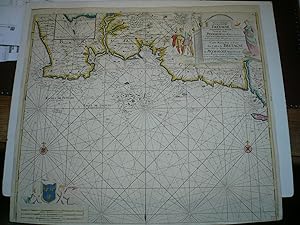
This is an authentic antique map of the Algerian coast, Balearic Islands and a portion of Spain. The map was published in Amsterdam by the Van Keulen family circa 1680. This lovely sea chart focuses on the Balearic Islands off the coast of Spain with much of the Algerian coastline displayed along the top. The map is presented with a southern orientation with two compass roses pointing to the bottom of the map, indicating north. Numerous depth soundings, anchorages, and hazards are noted throughout. Ports and coastal towns are also indicated, some of which include Barcelona, Mallorca, and Algiers. An insert in the top left focuses on the bay of Algiers. Una gran hoja de papel verjurado con filigrana. Muy buen estado de conservación. 53x61,5 cm.
-
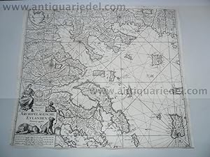
Negroponte,Greece,Seamap,anno 1690,van Keulen J.,Archipelagusche
Edité par Keulen Johannes van 1654-1715, 1715
Vendeur : Hammelburger Antiquariat, Hammelburg, Allemagne
Evaluation du vendeur :
Hardcover. Etat : very good. Negroponte,Greece,Seamap,anno 1690,van Keulen J.,Archipelagusche Seamap, edited by Johannes van Keulen, approx. anno 1690, "PASKAART Van de ARCHIPELAGUSCHE EYLANDEN ." North-east-Greece, with Negroponte, Volos, size of the leaf: 51 x 58 cm., little brownish.
-
Nieuwe Paskaart van het CANAAL VAN BRISTOL, van Keulen, anno 175
Edité par Keulen Johannes van 1654-1715, 1715
Vendeur : Hammelburger Antiquariat, Hammelburg, Allemagne
Evaluation du vendeur :
Hardcover. Etat : very good. Nieuwe Paskaart van het CANAAL VAN BRISTOL, van Keulen, anno 1750 Original and Decorative coloured, large-size copper engraving sea chart by Gerard van Keulen after Johannes van Keulen, printed in Amsterdam about 1750 AD map of the Bristol Channel - England "Nieuwe Paskaart van het Canaal van Bristol . " Johannes van Keulen (1654 Deventer - 1715, Amsterdam) was a 17th-Century Dutch cartographer who specialized in marine charts Gerard van Keulen (1678-1726) continued the work of his father, and produced new editions of the most influential sea atlases. A rare and very decoratively colored copper engraving map by Johannes van Keulen. This large-size sea chart shows the Bristol Channel in England with the cities of Barnstaple, Swansea, Cardiff and Weston-super-Mare. The map is decorated with a title cartouche. Size: Leaf app.: 100,5 x 61,0 cm engraving app.: 95,0 x 56,5 cm Condition: very good condition, printed on thick paper, strong print & beautiful colours, marginal water stained at the edges, Please have a look at the pictures! A Certificate of Authenticity (COA) can be issued on request.
-
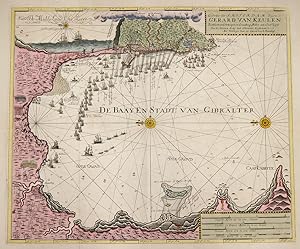
Gedrukt tot Amsterdam By Gerard van Keulen Boek Zeekaard Verkooper en Graadboog Maker aan Oost Zyde van de Nieuwen Brüg inde Gekroonde Lootsman
Edité par Artist: Keulen Johannes van ( - 1715 ) Amsterdam ; issued in: Amsterdam ; ca: 1680; - Johannes van Keulen (1654 - 1715) was a 17th-century Dutch cartographer He published the influential nautical atlas the Zee-Atlas and the pilot guide Zee-Fakkel In 1678 Johannes van Keulen established himself in Amsterdam and in 1680 he obtained a patent from the States of Holland and West Friesland allowing him to print and publish maritime atlases and shipping guides These were books of maps and descriptions of itineraries used by helmsmen for safe navigation The patent was a kind of protection against illegal copying of produced books and charts This was especially important for the atlases which were made with extensive initial costs Van Keulen named h, 1654
Vendeur : Antique Sommer& Sapunaru KG, München, Allemagne
Membre d'association : ILAB VDA
Evaluation du vendeur :
Technic: Copper print; colorit: original colored; condition: Perfect condition, size (in cm): 51 x 61; - Detailed map of the bay of Gibraltar with decorative offshore shipps. Vith a total view of the city Gibraltar and describing thewater depths of the coast.
-
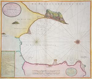
Nieuwe en seer nette Caart vam de Baay en Stadt Gibraltar,
Edité par Artist: Keulen Johannes van ( - 1715 ) Amsterdam ; issued in: Amsterdam ; ca: 1700; - Johannes van Keulen (1654 - 1715) was a 17th-century Dutch cartographer He published the influential nautical atlas the Zee-Atlas and the pilot guide Zee-Fakkel In 1678 Johannes van Keulen established himself in Amsterdam and in 1680 he obtained a patent from the States of Holland and West Friesland allowing him to print and publish maritime atlases and shipping guides These were books of maps and descriptions of itineraries used by helmsmen for safe navigation The patent was a kind of protection against illegal copying of produced books and charts This was especially important for the atlases which were made with extensive initial costs Van Keulen named h, 1654
Vendeur : Antique Sommer& Sapunaru KG, München, Allemagne
Membre d'association : ILAB VDA
Evaluation du vendeur :
Technic: Copper print; colorit: colored; condition: Perfect condition, size (in cm): 51 x 60 cm; - Map shows the Bay of Gibraltar with Gibraltar from a bird's eye view with index and a wind rose.
-
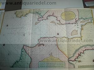
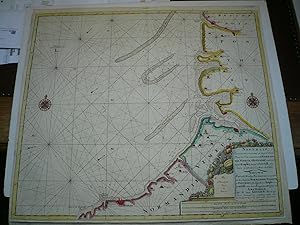
Nieuwe Paskaert van de Oost Cust van Engeland en Schotland.
Edité par Artist: Keulen Johannes van ( - 1715 ) Amsterdam ; issued in: Amsterdam ; ca: 1724; - Johannes van Keulen (1654 - 1715) was a 17th-century Dutch cartographer He published the influential nautical atlas the Zee-Atlas and the pilot guide Zee-Fakkel In 1678 Johannes van Keulen established himself in Amsterdam and in 1680 he obtained a patent from the States of Holland and West Friesland allowing him to print and publish maritime atlases and shipping guides These were books of maps and descriptions of itineraries used by helmsmen for safe navigation The patent was a kind of protection against illegal copying of produced books and charts This was especially important for the atlases which were made with extensive initial costs Van Keulen named h, 1654
Vendeur : Antique Sommer& Sapunaru KG, München, Allemagne
Membre d'association : ILAB VDA
Evaluation du vendeur :
Carte
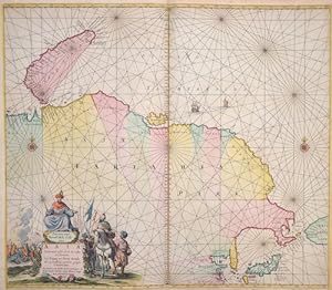
Technic: Copper print; colorit: original colored; condition: Upper margin perfectly enlarged, size (in cm): 51 x 58,5; - Map shows the North Sea with the coasts of Engalnd and Scottland from Flamborough Head to Berwick, inset maps shows the river Tyne from the city New Castle to the estuary.; - Special feature: From "Nouveau et Grand Illuminant Flambeau de la Mer".
-
Paskaart/Straat Gibraltar, anno 1715, van Keulen, map
Edité par Keulen Johannes van 1654-1715, 1715
Vendeur : Hammelburger Antiquariat, Hammelburg, Allemagne
Evaluation du vendeur :
Hardcover. Etat : very good. Coppermap, edited by J. van Keulen, approx. anno 1715, size of the map: 53x59 cm., printed on thick paper, little brownish, scarce map of Gibraltar, edited by van Keulen.
-
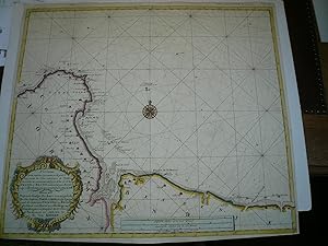
Nieuwe Pas-kaert vande oost Kust van Yrland van de hoeck van Wat
Edité par Keulen Johannes van 1654-1715, 1715
Vendeur : Hammelburger Antiquariat, Hammelburg, Allemagne
Evaluation du vendeur :
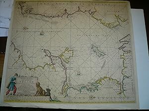
Hardcover. Etat : very good. Nieuwe Pas-kaert vande oost Kust van Yrland van de hoeck van Waterfoort tot aen de Mayds, Als mede de west Kust van Engeland". Grenzkol. Kupferstichkarte von J. van Keulen, um 1720. Qu.Imp.Fol., 54x60 cm., Mit fig. ausgem. Kart., kl. Windrose u. 2 Segelschiffen. - Leicht angestaubt, kl. Randläs. Large sea chart covering St. George's Channel with the coasts of Ireland and England. Nice detail of the coastlines and islands including anchorages and soundings. Rhumb lines, sailing ships, and compass roses adorn the map and the title cartouche features a boy and two dogs.
-
Nieuwe Pascaart van een Gedeelte van Bretagne beginnende Van 't
Edité par Keulen Johannes van 1654-1715, 1715
Vendeur : Hammelburger Antiquariat, Hammelburg, Allemagne
Evaluation du vendeur :
Hardcover. Etat : very good. Nieuwe Pascaart van een Gedeelte van Bretagne beginnende Van 't Eylandt Groa tot aan de Penmarck. Copperengraving, edited by the Van Keulen Family, circa anno 1740, old colours, size of the sheet: 52x60 cm.
-
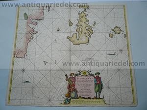
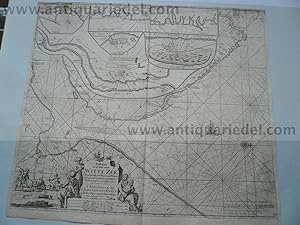
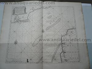
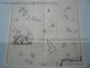
Paskaarte van de Mont van de Witte Zeen .Beginnende van Tiepena tot Pelitza
Edité par Artist: Keulen Johannes van ( - 1715 ) Amsterdam ; issued in: Amsterdam ; ca: 1690; - Johannes van Keulen (1654 - 1715) was a 17th-century Dutch cartographer He published the influential nautical atlas the Zee-Atlas and the pilot guide Zee-Fakkel In 1678 Johannes van Keulen established himself in Amsterdam and in 1680 he obtained a patent from the States of Holland and West Friesland allowing him to print and publish maritime atlases and shipping guides These were books of maps and descriptions of itineraries used by helmsmen for safe navigation The patent was a kind of protection against illegal copying of produced books and charts This was especially important for the atlases which were made with extensive initial costs Van Keulen named h, 1654
Vendeur : Antique Sommer& Sapunaru KG, München, Allemagne
Membre d'association : ILAB VDA
Evaluation du vendeur :
Carte
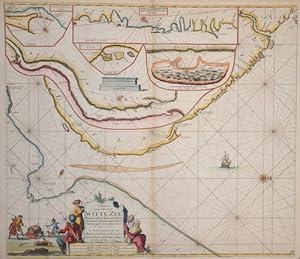
Technic: Copper print; colorit: original colored; condition: Very good, size (in cm): 51 x 59; - Map shows the white ocean between lapland and Russia / On five seperate maps: River Tumola, Svetenoes, Longbascho, Kildin, and a part of the coast Lapland. In the White Sea are the Solovetsky Islands with the labyrinths on Bolshoi Sajazki and the Morshovets Island.
-
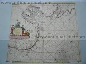
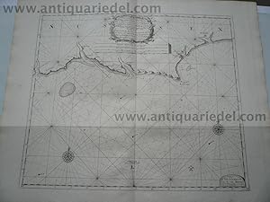
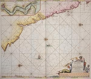
Pascaarte vande Noord Oost Cust van Asia.van Japan tot nova Zemla
Edité par Artist: Keulen Johannes van ( - 1715 ) Amsterdam ; issued in: Amsterdam ; ca: 1680; - Johannes van Keulen (1654 - 1715) was a 17th-century Dutch cartographer He published the influential nautical atlas the Zee-Atlas and the pilot guide Zee-Fakkel In 1678 Johannes van Keulen established himself in Amsterdam and in 1680 he obtained a patent from the States of Holland and West Friesland allowing him to print and publish maritime atlases and shipping guides These were books of maps and descriptions of itineraries used by helmsmen for safe navigation The patent was a kind of protection against illegal copying of produced books and charts This was especially important for the atlases which were made with extensive initial costs Van Keulen named h, 1654
Vendeur : Antique Sommer& Sapunaru KG, München, Allemagne
Membre d'association : ILAB VDA
Evaluation du vendeur :
Carte
Technic: Copper print; colorit: original colored; condition: Left, right and upper margin perfectly replaced, size (in cm): 52 x 60; - Map shows the north part of Asia with Japan and Nowaja-Semljaand the north polar sea.
-
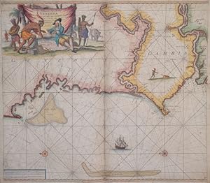
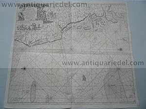
Nieuve paskert, van de Kust van Genehoa als Mede en gedeelte van Gambia, beginnende an C. Blanco tot C. Verde .
Edité par Artist: Keulen Johannes van ( - 1715 ) Amsterdam ; issued in: Amsterdam ; ca: 1690; - Johannes van Keulen (1654 - 1715) was a 17th-century Dutch cartographer He published the influential nautical atlas the Zee-Atlas and the pilot guide Zee-Fakkel In 1678 Johannes van Keulen established himself in Amsterdam and in 1680 he obtained a patent from the States of Holland and West Friesland allowing him to print and publish maritime atlases and shipping guides These were books of maps and descriptions of itineraries used by helmsmen for safe navigation The patent was a kind of protection against illegal copying of produced books and charts This was especially important for the atlases which were made with extensive initial costs Van Keulen named h, 1654
Vendeur : Antique Sommer& Sapunaru KG, München, Allemagne
Membre d'association : ILAB VDA
Evaluation du vendeur :
Carte
Technic: Copper print; colorit: colored; condition: Upper Left margin perfectly replaced, some restoration at centerfold, size (in cm): 49,5 x 75; - Map shows the coast Mauretania, Senegal and Gambia.
-
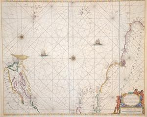
Pascaerte van de Vlaemsche, Soute, en Caribesche Eylanden.
Edité par Artist: Keulen Johannes van ( - 1715 ) Amsterdam ; issued in: Amsterdam ; ca: 1680; - Johannes van Keulen (1654 - 1715) was a 17th-century Dutch cartographer He published the influential nautical atlas the Zee-Atlas and the pilot guide Zee-Fakkel In 1678 Johannes van Keulen established himself in Amsterdam and in 1680 he obtained a patent from the States of Holland and West Friesland allowing him to print and publish maritime atlases and shipping guides These were books of maps and descriptions of itineraries used by helmsmen for safe navigation The patent was a kind of protection against illegal copying of produced books and charts This was especially important for the atlases which were made with extensive initial costs Van Keulen named h, 1654
Vendeur : Antique Sommer& Sapunaru KG, München, Allemagne
Membre d'association : ILAB VDA
Evaluation du vendeur :
Carte
Technic: Copper print; colorit: colored; condition: Very good, size (in cm): 45 x 54; - chart of the Atlantic Ocean with the estern coast of America from New Foundland to Brazil.
-
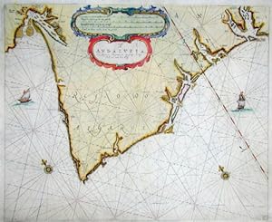
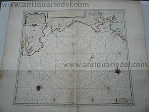
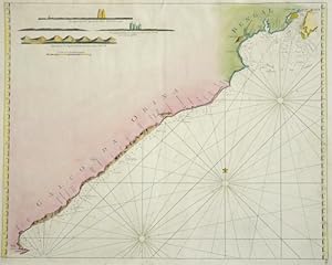
Cust van Andaluzia, En Algarve Beginnende van Capo de Spichel tot aen het Clif
Edité par Artist: Keulen Johannes van ( - 1715 ) Amsterdam ; issued in: Amsterdam ; ca: 1690; - Johannes van Keulen (1654 - 1715) was a 17th-century Dutch cartographer He published the influential nautical atlas the Zee-Atlas and the pilot guide Zee-Fakkel In 1678 Johannes van Keulen established himself in Amsterdam and in 1680 he obtained a patent from the States of Holland and West Friesland allowing him to print and publish maritime atlases and shipping guides These were books of maps and descriptions of itineraries used by helmsmen for safe navigation The patent was a kind of protection against illegal copying of produced books and charts This was especially important for the atlases which were made with extensive initial costs Van Keulen named h, 1654
Vendeur : Antique Sommer& Sapunaru KG, München, Allemagne
Membre d'association : ILAB VDA
Evaluation du vendeur :
Technic: Copper print; colorit: original colored; condition: Lower margin perfectly restored, some restoration at centerfold, size (in cm): 42 x 51; - Map shows the coast Algarve and the coast Andalusia to Talos.
-
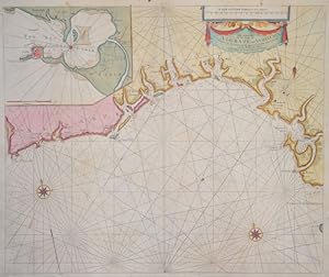
A Carte of the See Coast Algrave and Andalusia .
Edité par Artist: Keulen Johannes van ( - 1715 ) Amsterdam ; issued in: Amsterdam ; ca: 1690; - Johannes van Keulen (1654 - 1715) was a 17th-century Dutch cartographer He published the influential nautical atlas the Zee-Atlas and the pilot guide Zee-Fakkel In 1678 Johannes van Keulen established himself in Amsterdam and in 1680 he obtained a patent from the States of Holland and West Friesland allowing him to print and publish maritime atlases and shipping guides These were books of maps and descriptions of itineraries used by helmsmen for safe navigation The patent was a kind of protection against illegal copying of produced books and charts This was especially important for the atlases which were made with extensive initial costs Van Keulen named h, 1654
Vendeur : Antique Sommer& Sapunaru KG, München, Allemagne
Membre d'association : ILAB VDA
Evaluation du vendeur :
Carte
Technic: Copper print; colorit: original colored; condition: Some restoration at lower centerfold, size (in cm): 43,50 x 52; - Chart shows the Atlantic coast of Andalusia and Algarve, with a seperate map of the bay Cadiz.