
Montant total (1 article articles) :
Destination de la commande :

keulen johannes amsterdam (19 résultats)
Passer aux résultats principaux de la recherche
Type d'article
- Tous les types d'articles
- Livres (8)
- Magazines & Périodiques
- Bandes dessinées
- Partitions de musique
- Art, Affiches et Gravures
- Photographies
- Cartes (11)
-
Manuscrits &
Papiers anciens
Etat
Reliure
- Toutes
- Couverture rigide (1)
- Couverture souple
Particularités
- Edition originale
- Signé
- Jaquette
- Avec images
- Sans impression ŕ la demande (18)
Pays
Evaluation du vendeur
-
![Image du vendeur pour Verhandeling der zee-horenkens en zee-gewassen in en omtrent Amboina en de nabygelegen eilanden, [LeatherBound] mis en vente par True World of Books](https://pictures.abebooks.com/inventory/md/md31533062685.jpg)
Verhandeling der zee-horenkens en zee-gewassen in en omtrent Amboina en de nabygelegen eilanden, [LeatherBound]
Date d'édition : 2023
Livre impression ŕ la demande
LeatherBound. Etat : New. LeatherBound edition. Condition: New. Reprinted from 1754 edition. Leather Binding on Spine and Corners with Golden leaf printing on spine. Bound in genuine leather with Satin ribbon page markers and Spine with raised gilt bands. A perfect gift for your loved ones. NO changes have been made to the original text. This is NOT a retyped or an ocr'd reprint. Illustrations, Index, if any, are included in black and white. Each page is checked manually before printing. As this print on demand book is reprinted from a very old book, there could be some missing or flawed pages, but we always try to make the book as complete as possible. Fold-outs, if any, are not part of the book. If the original book was published in multiple volumes then this reprint is of only one volume, not the whole set. Sewing binding for longer life, where the book block is actually sewn (smythe sewn/section sewn) with thread before binding which results in a more durable type of binding. Pages: 124 Language: Dutch.
-
Paskaart, voor een Gedeelte der Kust van, Barbaria, van C. Ivi, tot Bona. En de Kust van, Catalonia.Eylanden, Yvica, Majorca, en Minorca
Edité par Artist: Keulen Johannes van ( - 1715 ) Amsterdam ; issued in: Amsterdam ; ca: 1750; - Johannes van Keulen (1654 - 1715) was a 17th-century Dutch cartographer He published the influential nautical atlas the Zee-Atlas and the pilot guide Zee-Fakkel In 1678 Johannes van Keulen established himself in Amsterdam and in 1680 he obtained a patent from the States of Holland and West Friesland allowing him to print and publish maritime atlases and shipping guides These were books of maps and descriptions of itineraries used by helmsmen for safe navigation The patent was a kind of protection against illegal copying of produced books and charts This was especially important for the atlases which were made with extensive initial costs Van Keulen named h, 1654
Vendeur : Antique Sommer& Sapunaru KG, München, Allemagne
Membre d'association : ILAB VDA
Evaluation du vendeur :

Technic: Copper print; colorit: colored; condition: Upper and lower margin cutted, missing part!, size (in cm): 36 x 58; - Part of the map from van Keulen of the coast of Catalonia, Majorca, Minorca, Ibiza and part of the Barbary coast.; - Special feature: De Nieuwe Groote Lichtende Zee-Fackel.
-

Cust van Hispangien"
Edité par Artist: Keulen Johannes van ( - 1715 ) Amsterdam ; issued in: Amsterdam ; ca: 1680; - Johannes van Keulen (1654 - 1715) was a 17th-century Dutch cartographer He published the influential nautical atlas the Zee-Atlas and the pilot guide Zee-Fakkel In 1678 Johannes van Keulen established himself in Amsterdam and in 1680 he obtained a patent from the States of Holland and West Friesland allowing him to print and publish maritime atlases and shipping guides These were books of maps and descriptions of itineraries used by helmsmen for safe navigation The patent was a kind of protection against illegal copying of produced books and charts This was especially important for the atlases which were made with extensive initial costs Van Keulen named h, 1654
Vendeur : Antique Sommer& Sapunaru KG, München, Allemagne
Membre d'association : ILAB VDA
Evaluation du vendeur :
Carte
Technic: Copper print; colorit: colored; condition: Very good, size (in cm): 39 x 52; - chart of the Strait of Gibraltar.
-
Galconda Orixa Bengal
Edité par Artist: Keulen Johannes van ( - 1715 ) Amsterdam ; issued in: Amsterdam ; ca: 1690; - Johannes van Keulen (1654 - 1715) was a 17th-century Dutch cartographer He published the influential nautical atlas the Zee-Atlas and the pilot guide Zee-Fakkel In 1678 Johannes van Keulen established himself in Amsterdam and in 1680 he obtained a patent from the States of Holland and West Friesland allowing him to print and publish maritime atlases and shipping guides These were books of maps and descriptions of itineraries used by helmsmen for safe navigation The patent was a kind of protection against illegal copying of produced books and charts This was especially important for the atlases which were made with extensive initial costs Van Keulen named h, 1654
Vendeur : Antique Sommer& Sapunaru KG, München, Allemagne
Membre d'association : ILAB VDA
Evaluation du vendeur :
Technic: Copper print; colorit: original colored; condition: Tear on upper margin perfectly restored, size (in cm): 44,5 x 56; - Map depicts the south eastern coast of India with the source of the river Ganges.
-
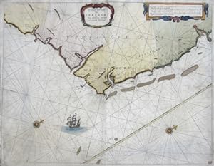
De Zuyd Oost zyde van Yerlandt van Dubing tot aen t Eylandt Corkbeg
Edité par Artist: Keulen Johannes van ( - 1715 ) Amsterdam ; issued in: Amsterdam ; ca: 1700; - Johannes van Keulen (1654 - 1715) was a 17th-century Dutch cartographer He published the influential nautical atlas the Zee-Atlas and the pilot guide Zee-Fakkel In 1678 Johannes van Keulen established himself in Amsterdam and in 1680 he obtained a patent from the States of Holland and West Friesland allowing him to print and publish maritime atlases and shipping guides These were books of maps and descriptions of itineraries used by helmsmen for safe navigation The patent was a kind of protection against illegal copying of produced books and charts This was especially important for the atlases which were made with extensive initial costs Van Keulen named h, 1654
Vendeur : Antique Sommer& Sapunaru KG, München, Allemagne
Membre d'association : ILAB VDA
Evaluation du vendeur :
Technic: Copper print; colorit: original colored; condition: Very good, size (in cm): 41 x 53; - Map shows the cast of Ireland from Corkbeg to Dublin.
-
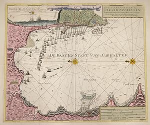
Gedrukt tot Amsterdam By Gerard van Keulen Boek Zeekaard Verkooper en Graadboog Maker aan Oost Zyde van de Nieuwen Brüg inde Gekroonde Lootsman
Edité par Artist: Keulen Johannes van ( - 1715 ) Amsterdam ; issued in: Amsterdam ; ca: 1680; - Johannes van Keulen (1654 - 1715) was a 17th-century Dutch cartographer He published the influential nautical atlas the Zee-Atlas and the pilot guide Zee-Fakkel In 1678 Johannes van Keulen established himself in Amsterdam and in 1680 he obtained a patent from the States of Holland and West Friesland allowing him to print and publish maritime atlases and shipping guides These were books of maps and descriptions of itineraries used by helmsmen for safe navigation The patent was a kind of protection against illegal copying of produced books and charts This was especially important for the atlases which were made with extensive initial costs Van Keulen named h, 1654
Vendeur : Antique Sommer& Sapunaru KG, München, Allemagne
Membre d'association : ILAB VDA
Evaluation du vendeur :
Technic: Copper print; colorit: original colored; condition: Perfect condition, size (in cm): 51 x 61; - Detailed map of the bay of Gibraltar with decorative offshore shipps. Vith a total view of the city Gibraltar and describing thewater depths of the coast.
-
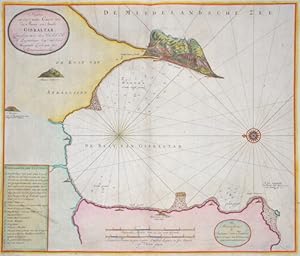
Nieuwe en seer nette Caart vam de Baay en Stadt Gibraltar,
Edité par Artist: Keulen Johannes van ( - 1715 ) Amsterdam ; issued in: Amsterdam ; ca: 1700; - Johannes van Keulen (1654 - 1715) was a 17th-century Dutch cartographer He published the influential nautical atlas the Zee-Atlas and the pilot guide Zee-Fakkel In 1678 Johannes van Keulen established himself in Amsterdam and in 1680 he obtained a patent from the States of Holland and West Friesland allowing him to print and publish maritime atlases and shipping guides These were books of maps and descriptions of itineraries used by helmsmen for safe navigation The patent was a kind of protection against illegal copying of produced books and charts This was especially important for the atlases which were made with extensive initial costs Van Keulen named h, 1654
Vendeur : Antique Sommer& Sapunaru KG, München, Allemagne
Membre d'association : ILAB VDA
Evaluation du vendeur :
Technic: Copper print; colorit: colored; condition: Perfect condition, size (in cm): 51 x 60 cm; - Map shows the Bay of Gibraltar with Gibraltar from a bird's eye view with index and a wind rose.
-
Nieuwe Paskaert van de Oost Cust van Engeland en Schotland.
Edité par Artist: Keulen Johannes van ( - 1715 ) Amsterdam ; issued in: Amsterdam ; ca: 1724; - Johannes van Keulen (1654 - 1715) was a 17th-century Dutch cartographer He published the influential nautical atlas the Zee-Atlas and the pilot guide Zee-Fakkel In 1678 Johannes van Keulen established himself in Amsterdam and in 1680 he obtained a patent from the States of Holland and West Friesland allowing him to print and publish maritime atlases and shipping guides These were books of maps and descriptions of itineraries used by helmsmen for safe navigation The patent was a kind of protection against illegal copying of produced books and charts This was especially important for the atlases which were made with extensive initial costs Van Keulen named h, 1654
Vendeur : Antique Sommer& Sapunaru KG, München, Allemagne
Membre d'association : ILAB VDA
Evaluation du vendeur :
Carte
Technic: Copper print; colorit: original colored; condition: Upper margin perfectly enlarged, size (in cm): 51 x 58,5; - Map shows the North Sea with the coasts of Engalnd and Scottland from Flamborough Head to Berwick, inset maps shows the river Tyne from the city New Castle to the estuary.; - Special feature: From "Nouveau et Grand Illuminant Flambeau de la Mer".
-
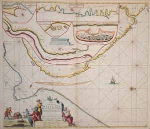
Paskaarte van de Mont van de Witte Zeen .Beginnende van Tiepena tot Pelitza
Edité par Artist: Keulen Johannes van ( - 1715 ) Amsterdam ; issued in: Amsterdam ; ca: 1690; - Johannes van Keulen (1654 - 1715) was a 17th-century Dutch cartographer He published the influential nautical atlas the Zee-Atlas and the pilot guide Zee-Fakkel In 1678 Johannes van Keulen established himself in Amsterdam and in 1680 he obtained a patent from the States of Holland and West Friesland allowing him to print and publish maritime atlases and shipping guides These were books of maps and descriptions of itineraries used by helmsmen for safe navigation The patent was a kind of protection against illegal copying of produced books and charts This was especially important for the atlases which were made with extensive initial costs Van Keulen named h, 1654
Vendeur : Antique Sommer& Sapunaru KG, München, Allemagne
Membre d'association : ILAB VDA
Evaluation du vendeur :
Carte
Technic: Copper print; colorit: original colored; condition: Very good, size (in cm): 51 x 59; - Map shows the white ocean between lapland and Russia / On five seperate maps: River Tumola, Svetenoes, Longbascho, Kildin, and a part of the coast Lapland. In the White Sea are the Solovetsky Islands with the labyrinths on Bolshoi Sajazki and the Morshovets Island.
-
Pascaarte vande Noord Oost Cust van Asia.van Japan tot nova Zemla
Edité par Artist: Keulen Johannes van ( - 1715 ) Amsterdam ; issued in: Amsterdam ; ca: 1680; - Johannes van Keulen (1654 - 1715) was a 17th-century Dutch cartographer He published the influential nautical atlas the Zee-Atlas and the pilot guide Zee-Fakkel In 1678 Johannes van Keulen established himself in Amsterdam and in 1680 he obtained a patent from the States of Holland and West Friesland allowing him to print and publish maritime atlases and shipping guides These were books of maps and descriptions of itineraries used by helmsmen for safe navigation The patent was a kind of protection against illegal copying of produced books and charts This was especially important for the atlases which were made with extensive initial costs Van Keulen named h, 1654
Vendeur : Antique Sommer& Sapunaru KG, München, Allemagne
Membre d'association : ILAB VDA
Evaluation du vendeur :
Carte
Technic: Copper print; colorit: original colored; condition: Left, right and upper margin perfectly replaced, size (in cm): 52 x 60; - Map shows the north part of Asia with Japan and Nowaja-Semljaand the north polar sea.
-
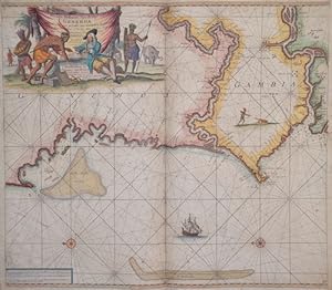
Nieuve paskert, van de Kust van Genehoa als Mede en gedeelte van Gambia, beginnende an C. Blanco tot C. Verde .
Edité par Artist: Keulen Johannes van ( - 1715 ) Amsterdam ; issued in: Amsterdam ; ca: 1690; - Johannes van Keulen (1654 - 1715) was a 17th-century Dutch cartographer He published the influential nautical atlas the Zee-Atlas and the pilot guide Zee-Fakkel In 1678 Johannes van Keulen established himself in Amsterdam and in 1680 he obtained a patent from the States of Holland and West Friesland allowing him to print and publish maritime atlases and shipping guides These were books of maps and descriptions of itineraries used by helmsmen for safe navigation The patent was a kind of protection against illegal copying of produced books and charts This was especially important for the atlases which were made with extensive initial costs Van Keulen named h, 1654
Vendeur : Antique Sommer& Sapunaru KG, München, Allemagne
Membre d'association : ILAB VDA
Evaluation du vendeur :
Carte
Technic: Copper print; colorit: colored; condition: Upper Left margin perfectly replaced, some restoration at centerfold, size (in cm): 49,5 x 75; - Map shows the coast Mauretania, Senegal and Gambia.
-
Pascaerte van de Vlaemsche, Soute, en Caribesche Eylanden.
Edité par Artist: Keulen Johannes van ( - 1715 ) Amsterdam ; issued in: Amsterdam ; ca: 1680; - Johannes van Keulen (1654 - 1715) was a 17th-century Dutch cartographer He published the influential nautical atlas the Zee-Atlas and the pilot guide Zee-Fakkel In 1678 Johannes van Keulen established himself in Amsterdam and in 1680 he obtained a patent from the States of Holland and West Friesland allowing him to print and publish maritime atlases and shipping guides These were books of maps and descriptions of itineraries used by helmsmen for safe navigation The patent was a kind of protection against illegal copying of produced books and charts This was especially important for the atlases which were made with extensive initial costs Van Keulen named h, 1654
Vendeur : Antique Sommer& Sapunaru KG, München, Allemagne
Membre d'association : ILAB VDA
Evaluation du vendeur :
Carte
Technic: Copper print; colorit: colored; condition: Very good, size (in cm): 45 x 54; - chart of the Atlantic Ocean with the estern coast of America from New Foundland to Brazil.
-
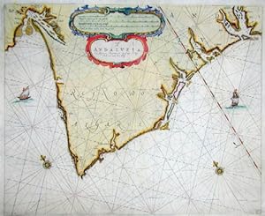
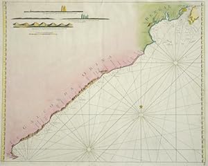
Cust van Andaluzia, En Algarve Beginnende van Capo de Spichel tot aen het Clif
Edité par Artist: Keulen Johannes van ( - 1715 ) Amsterdam ; issued in: Amsterdam ; ca: 1690; - Johannes van Keulen (1654 - 1715) was a 17th-century Dutch cartographer He published the influential nautical atlas the Zee-Atlas and the pilot guide Zee-Fakkel In 1678 Johannes van Keulen established himself in Amsterdam and in 1680 he obtained a patent from the States of Holland and West Friesland allowing him to print and publish maritime atlases and shipping guides These were books of maps and descriptions of itineraries used by helmsmen for safe navigation The patent was a kind of protection against illegal copying of produced books and charts This was especially important for the atlases which were made with extensive initial costs Van Keulen named h, 1654
Vendeur : Antique Sommer& Sapunaru KG, München, Allemagne
Membre d'association : ILAB VDA
Evaluation du vendeur :
Technic: Copper print; colorit: original colored; condition: Lower margin perfectly restored, some restoration at centerfold, size (in cm): 42 x 51; - Map shows the coast Algarve and the coast Andalusia to Talos.
-
A Carte of the See Coast Algrave and Andalusia .
Edité par Artist: Keulen Johannes van ( - 1715 ) Amsterdam ; issued in: Amsterdam ; ca: 1690; - Johannes van Keulen (1654 - 1715) was a 17th-century Dutch cartographer He published the influential nautical atlas the Zee-Atlas and the pilot guide Zee-Fakkel In 1678 Johannes van Keulen established himself in Amsterdam and in 1680 he obtained a patent from the States of Holland and West Friesland allowing him to print and publish maritime atlases and shipping guides These were books of maps and descriptions of itineraries used by helmsmen for safe navigation The patent was a kind of protection against illegal copying of produced books and charts This was especially important for the atlases which were made with extensive initial costs Van Keulen named h, 1654
Vendeur : Antique Sommer& Sapunaru KG, München, Allemagne
Membre d'association : ILAB VDA
Evaluation du vendeur :
Carte
Technic: Copper print; colorit: original colored; condition: Some restoration at lower centerfold, size (in cm): 43,50 x 52; - Chart shows the Atlantic coast of Andalusia and Algarve, with a seperate map of the bay Cadiz.
-
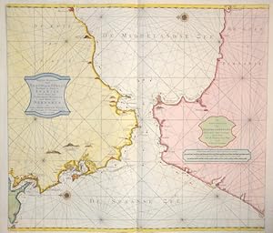
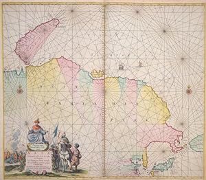
Nieuwe pascart van t Naauw van de Straad Strekkende de Kust van Spanjen Van de Rivier van Sivilien tot Mallaga en de Kust van Barbaria .
Edité par Artist: Keulen Johannes van ( - 1715 ) Amsterdam ; issued in: Amsterdam ; ca: 1690; - Johannes van Keulen (1654 - 1715) was a 17th-century Dutch cartographer He published the influential nautical atlas the Zee-Atlas and the pilot guide Zee-Fakkel In 1678 Johannes van Keulen established himself in Amsterdam and in 1680 he obtained a patent from the States of Holland and West Friesland allowing him to print and publish maritime atlases and shipping guides These were books of maps and descriptions of itineraries used by helmsmen for safe navigation The patent was a kind of protection against illegal copying of produced books and charts This was especially important for the atlases which were made with extensive initial costs Van Keulen named h, 1654
Vendeur : Antique Sommer& Sapunaru KG, München, Allemagne
Membre d'association : ILAB VDA
Evaluation du vendeur :
Carte
Technic: Copper print; colorit: original colored; condition: Tear on lower part perfectly restored, size (in cm): 50 x 57,5 cm; - Map shows Coast of Andalusia with the city Cadiz to Malaga, the coast of Marocco with the city Larache to Penon de Velez.
-
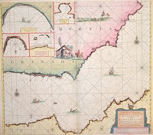
Pascaart van de Zee Kusten van Granada en Murica.
Edité par Artist: Keulen Johannes van ( - 1715 ) Amsterdam ; issued in: Amsterdam ; ca: 1680; - Johannes van Keulen (1654 - 1715) was a 17th-century Dutch cartographer He published the influential nautical atlas the Zee-Atlas and the pilot guide Zee-Fakkel In 1678 Johannes van Keulen established himself in Amsterdam and in 1680 he obtained a patent from the States of Holland and West Friesland allowing him to print and publish maritime atlases and shipping guides These were books of maps and descriptions of itineraries used by helmsmen for safe navigation The patent was a kind of protection against illegal copying of produced books and charts This was especially important for the atlases which were made with extensive initial costs Van Keulen named h, 1654
Vendeur : Antique Sommer& Sapunaru KG, München, Allemagne
Membre d'association : ILAB VDA
Evaluation du vendeur :
Carte
Technic: Copper print; colorit: original colored; condition: Very good, size (in cm): 62 x 59,5; - chart of the western Mediterranean Sea, east of Gibraltar.
-

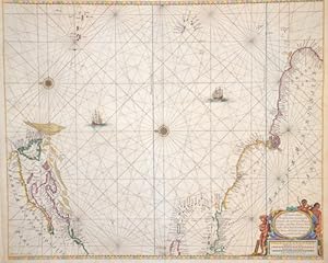
De Noordelyckte Kuste van America
Edité par Artist: Keulen Johannes van ( - 1715 ) Amsterdam ; issued in: Amsterdam ; ca: 1680; - Johannes van Keulen (1654 - 1715) was a 17th-century Dutch cartographer He published the influential nautical atlas the Zee-Atlas and the pilot guide Zee-Fakkel In 1678 Johannes van Keulen established himself in Amsterdam and in 1680 he obtained a patent from the States of Holland and West Friesland allowing him to print and publish maritime atlases and shipping guides These were books of maps and descriptions of itineraries used by helmsmen for safe navigation The patent was a kind of protection against illegal copying of produced books and charts This was especially important for the atlases which were made with extensive initial costs Van Keulen named h, 1654
Vendeur : Antique Sommer& Sapunaru KG, München, Allemagne
Membre d'association : ILAB VDA
Evaluation du vendeur :
Carte
Technic: Copper print; colorit: colored; condition: Very good, size (in cm): 49 x 56; - chart of northeastern Canada, Greenland, Baffin Bay.
-
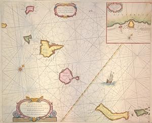
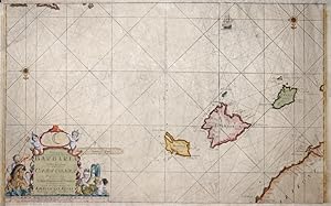
Caarte voor ee gedeelte der Canarisee Eylanden als Canaria ,Tenerifa, Forteventura, ect./De tyhavens porto de Naos en Posto de Cavallos .Lazerota
Edité par Artist: Keulen Johannes van ( - 1715 ) Amsterdam ; issued in: Amsterdam ; ca: 1690; - Johannes van Keulen (1654 - 1715) was a 17th-century Dutch cartographer He published the influential nautical atlas the Zee-Atlas and the pilot guide Zee-Fakkel In 1678 Johannes van Keulen established himself in Amsterdam and in 1680 he obtained a patent from the States of Holland and West Friesland allowing him to print and publish maritime atlases and shipping guides These were books of maps and descriptions of itineraries used by helmsmen for safe navigation The patent was a kind of protection against illegal copying of produced books and charts This was especially important for the atlases which were made with extensive initial costs Van Keulen named h, 1654
Vendeur : Antique Sommer& Sapunaru KG, München, Allemagne
Membre d'association : ILAB VDA
Evaluation du vendeur :
Technic: Copper print; colorit: original colored; condition: Some minor restoration at upper centerfold, size (in cm): 42 x 52; - Map shows the Canary Islands with seperste map showin the harbour of Lanzerote. Canary islands with Teneriffa, Fuerteventura, Gran Canaria, Lanzarote, La Palma, La Gomera und El Hierro.
-
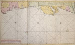
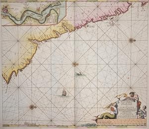
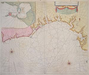
Nieuwe Generale Paskaart van de Cust van Portugal tusschen C: de Finissterre en: St. Vincent / The New Sea Map ofte Coast of Portugal Betwext C:.
Edité par Artist: Keulen Johannes van ( - 1715 ) Amsterdam ; issued in: Amsterdam ; ca: 1680; - Johannes van Keulen (1654 - 1715) was a 17th-century Dutch cartographer He published the influential nautical atlas the Zee-Atlas and the pilot guide Zee-Fakkel In 1678 Johannes van Keulen established himself in Amsterdam and in 1680 he obtained a patent from the States of Holland and West Friesland allowing him to print and publish maritime atlases and shipping guides These were books of maps and descriptions of itineraries used by helmsmen for safe navigation The patent was a kind of protection against illegal copying of produced books and charts This was especially important for the atlases which were made with extensive initial costs Van Keulen named h, 1654
Vendeur : Antique Sommer& Sapunaru KG, München, Allemagne
Membre d'association : ILAB VDA
Evaluation du vendeur :
Carte
Technic: Copper print; colorit: original colored; condition: Printed on 12 sheets joined together, size (in cm): 58,5 x 99,5 cm; - Chart shows the spanish and portugese coast with the cities Cee, Muros, Vigo, Porto, Setubal, Lissabon bis zu Fortaleza de Sao Vicente at the Algarve.