Montant total (1 article articles) :
Destination de la commande :

keulen johannes van claes jansz (3 résultats)
Passer aux résultats principaux de la recherche
Type d'article
- Tous les types d'articles
- Livres (3)
- Magazines & Périodiques
- Bandes dessinées
- Partitions de musique
- Art, Affiches et Gravures
- Photographies
- Cartes
-
Manuscrits &
Papiers anciens
Etat
- Tous
- Neuf
- Ancien ou d'occasion
Reliure
- Toutes
- Couverture rigide
- Couverture souple
Particularités
- Edition originale
- Signé
- Jaquette
- Avec images
- Sans impression ŕ la demande
Pays
Evaluation du vendeur
-
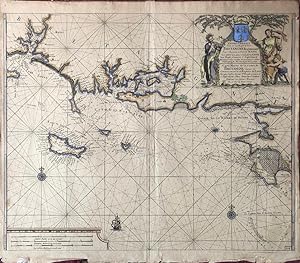
Nieuewe Pascaart Van de Zeekusten Van Bretangne Beginnende Van t' Incoomen Van de Rivier de Loire tot dan t' Eylandt de Groa door Vooght Geometra. (Also titled in French:) Carte Marine de la Costes de Bretangne depuis la Commancement de la Rivierre de Loire Jus'quia Isle de Groa Pr Vooght Geometra.
Edité par Amsterdam: Van Keulen, [c.1728]., 1728
Vendeur : William Matthews/The Haunted Bookshop, Sidney, BC, Canada
Membre d'association : ABAC ILAB
Evaluation du vendeur :

A copper engraved map on laid paper, large colour cartouche at top right containing a coat-of-arms, with text in Dutch and French. Map is hand-coloured. Also a small sailing ship and two compass roses. Imprint in cartouche: "t' Amsterdam by Johannes van Ceulen, Boekverkooper Aand Nieuwenbrugh Met Privilegie Voor 15 Iaar" and in French: "d'Amsterdam Chez Iean Van Ceulen Vendeur des Cartes Marines Vis a' Vis du Pont Neuf". Small number "22&1/2" printed in lower right corner. Plate size is 60cm x 49cm, on a sheet measuring 62cm x 54cm. Verso blank. An attractive map with a handsomely coloured cartouche. From Van Keulen's "De Nieuwe Groote Ligtende Zee-Fakkel." [1728 - many editions]. The cartouche attributes the map to Claes Jansz Vooght; the art in the cartouche may be by Jan Luyken, as he illustrated Van Keulen's Atlas. A map of the coast of France, Brittany and the coast near the mouth of the Loire River.
-
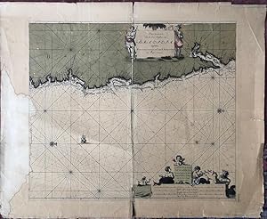
Pas-Kaart, Van de Zee-Kusten, van, Brazilia, Tusschen, Punto de Lucena en Cabo S. Augustino. Door Vooght, Geometra.
Edité par Amsterdam: Van Keulen, [c.1728]., 1728
Vendeur : William Matthews/The Haunted Bookshop, Sidney, BC, Canada
Membre d'association : ABAC ILAB
Evaluation du vendeur :
A copper engraved map on laid paper, large colour cartouches at top and bottom, map hand-coloured. Also a small sailing ship and two compass roses (North is indicated to the right of the map). Imprint in lower cartouche: 't Amsterdam, By, Iohannis Van Keulen, Boek en Zee-Kaart verkooper, aan de Niewe-brugh. Small number "13" printed in lower right corner. Plate size is 60cm x 51cm, on a sheet measuring 75cm x 61cm. Verso blank. Old stain to left side extending slightly into plate, yellow remains of old tape repairs to fold on verso, splitting along fold, tears to margins, otherwise generally very good. An attractive map with handsomely coloured cartouches. From Van Keulen's "De Nieuwe Groote Ligtende Zee-Fakkel." [1728 - many editions]. The map is by Claes Jansz Vooght; cartouche art may be by Jan Luyken, who illustrated Van Keulen's Atlas. A map of the East coast of Brazil. The upper cartouche depicts natives with weapons: a sword & shield and a bow; the lower cartouche depicts a mermaid, a sea god, and mermen, one of whom holds a Jacob's staff.
-
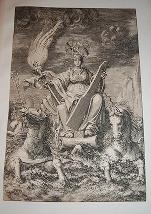
De Nieuwe Groote Lichtende Zee-Fakkel.FRONTISPIECE. Sea Goddess with Sea Torch. From First Edition.
Edité par Johannes van Keulen, 1681-1684., Amsterdam:, 1681
Vendeur : Dark Parks Books & Collectibles, Fallon, NV, Etats-Unis
Evaluation du vendeur :

From first edition. Very rare. Fantastic frontispiece. Trimmed just outside of border. Mounted on larger plain leaf. Privilege text is on verso. Suitable for framing, or perhaps mating with another copy. Dramatic frontispiece from Part IV of Keulen?s Zee-Fakkel, or ?Sea Torch? Illustrates a sea-goddess representing navigation and trade, with an armillary sphere as a head piece, in a shell chariot pulled by two sea-horses. She holds a rudder and a torch signifying the guidance by the atlas of the charts. Artist is Jan Luyken. Johannes van Keulen (1654-1715), Dutch bookseller and cartographer, publisher of the influential nautical works Zee-Atlas and the pilot guide Zee-Fakkel. The Zee-Fakkel was published in 5 volumes between 1681 and 1684, with over 130 new charts/maps by Claes Jansz Vooght and illustrations by Jan Luyken. The work made Keulen famous. Complete copies of the Zee-Fakkel, when on the market, fetch high six figures, monetarily. Citations: Keulen Cartography: 195-204. Amsterdam Museum: A51379.