
Montant total (1 article articles) :
Destination de la commande :

lotter isle t c augsburg (2 résultats)
Commentaires
Passer aux résultats principaux de la recherche
Filtres de recherche
Type d'article
- Tous les types de produits
- Livres (2)
- Magazines & Périodiques (Aucun autre résultat ne correspond ŕ ces critčres)
- Bandes dessinées (Aucun autre résultat ne correspond ŕ ces critčres)
- Partitions de musique (Aucun autre résultat ne correspond ŕ ces critčres)
- Art, Affiches et Gravures (Aucun autre résultat ne correspond ŕ ces critčres)
- Photographies (Aucun autre résultat ne correspond ŕ ces critčres)
- Cartes (Aucun autre résultat ne correspond ŕ ces critčres)
- Manuscrits & Papiers anciens (Aucun autre résultat ne correspond ŕ ces critčres)
Etat
- Tous
- Neuf (Aucun autre résultat ne correspond ŕ ces critčres)
- Ancien ou d'occasion (2)
Reliure
- Toutes
- Couverture rigide (Aucun autre résultat ne correspond ŕ ces critčres)
- Couverture souple (Aucun autre résultat ne correspond ŕ ces critčres)
Particularités
- Ed. originale (Aucun autre résultat ne correspond ŕ ces critčres)
- Signé (Aucun autre résultat ne correspond ŕ ces critčres)
- Jaquette (Aucun autre résultat ne correspond ŕ ces critčres)
- Avec images (2)
- Sans impressions ŕ la demande (2)
Livraison gratuite
- Livraison gratuite ŕ destination de France (Aucun autre résultat ne correspond ŕ ces critčres)
Evaluation du vendeur
-
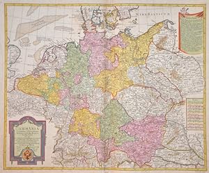
Germania secundum Observationes Tychonis de Brahe Kepleri.
Edité par Artist: Lotter/ de l Isle TC ( - 1777 ) Augsburg ; issued in: Augsburg; - Tobias Conrad Lotter ( 1717- 1777) was a carthographer and publisher in Augsburg He married the elder daughter of Matthäus Seutters and worked in the company of his father in la was map maker He produced under the ? eye? of M Seutter his first ? Asia minor? atlas between 1740 and 1744 The Asia minor altas of Lotter Praecipua orbis terrarum imperia regna et provincias Germania potissimum tabelli 80 exactae delineatis sistens usui militiae ducum ac peregrinantium maxime accommodatus opera contains 63 maps mosly Lotters work and other maps from Seutter where he put his name in the lower margin, 1717
Vendeur : Antique Sommer& Sapunaru KG, München, Allemagne
Membre d'association : ILAB VDA
Évaluation du vendeur 4 sur 5 étoiles

Technic: Copper print, colorit: original colored, condition: Some restoration at centerfold, size (in cm): 48 x 59 cm; - Map shows the whole of Germany with Silesia, Bohemia, the Netherlands, Belgium, Alsace, Switzerland, Tyrol and Austria. In addition, two cartouches, one with the German double-headed eagle and a mileage indicator cartouche.; History: The concept of Germany as a distinct region in central Europe can be traced to Roman commander Julius Caesar, who referred to the unconquered area east of the Rhine as Germania, thus distinguishing it from Gaul (France), which he had conquered. In the High Middle Ages, the regional dukes, princes and bishops gained power at the expense of the emperors. Martin Luther led the Protestant Reformationagainst the Catholic Church after 1517, as the northern states became Protestant, while the southern states remained Catholic. The two parts of the Holy Roman Empire clashed in the Thirty Years' War (1618?1648). 1648 marked the effective end of the Holy Roman Empire and the beginning of the modern nation-state system, with Germany divided into numerous independent states, such as Prussia, Bavaria and Saxony.
-

Africae
Edité par Artist: Lotter/ de l Isle TC ( - 1777 ) Augsburg ; issued in: Augsburg; - Tobias Conrad Lotter ( 1717- 1777) was a carthographer and publisher in Augsburg He married the elder daughter of Matthäus Seutters and worked in the company of his father in la was map maker He produced under the ? eye? of M Seutter his first ? Asia minor? atlas between 1740 and 1744 The Asia minor altas of Lotter Praecipua orbis terrarum imperia regna et provincias Germania potissimum tabelli 80 exactae delineatis sistens usui militiae ducum ac peregrinantium maxime accommodatus opera contains 63 maps mosly Lotters work and other maps from Seutter where he put his name in the lower margin, 1717
Vendeur : Antique Sommer& Sapunaru KG, München, Allemagne
Membre d'association : ILAB VDA
Évaluation du vendeur 4 sur 5 étoiles
Technic: Copper print, colorit: original colored, condition: Restoration at centerfold, size (in cm): 45 x 58; - Map of Africa.; History: According to the "Out-of-Africa theory", Africa is considered the "cradle of mankind", where homo development led to the development of the anatomically modern human Homo sapiens. One of the earliest advanced civilizations in mankind was formed in ancient Egypt. Over the millennia, various "great empires" such as the Empire of Abyssinia emerged on the continent. There were other kingdoms in West Africa, such as the Ashanti and Haussa, but they emerged much later. There were also some important cultures in East and South Africa, as in the area of today's Sudan, then called Nubia or Kush. Nubian pharaohs ruled all of Egypt for a dynasty. For example, the inhabitants of Greater Zimbabwe were important cultures in southern Africa. This stone castle was architecturally a masterpiece at that time and important for trade between the peoples of the south and east. The Swahili were known in East Africa. North Africa was connected to Europe and the Near East by the Mediterranean rather than separated. Carthage, a foundation of the Phoenicians in what is now Tunisia, was around the middle of the 1st millennium BC. The dominant power in the western Mediterranean until it was replaced by Rome in the Punic Wars. This prevailed from 30 BC. BC (conquest of Egypt) over all of North Africa. Even the ancient Egyptians (Queen Hatshepsut) made trips to Punt, probably in what is now Somalia. The kingdom of the Queen of Sheba, which probably had its center in southern Arabia, is said to have spanned parts of the Horn from Africa to the north of Ethiopia.