Montant total (1 article articles) :
Destination de la commande :

mercator gerard hondius henricus (10 résultats)
Passer aux résultats principaux de la recherche
Type d'article
- Tous les types d'articles
- Livres (2)
- Magazines & Périodiques
- Bandes dessinées
- Partitions de musique
- Art, Affiches et Gravures (2)
- Photographies
- Cartes (6)
-
Manuscrits &
Papiers anciens
Etat
- Tous
- Neuf
- Ancien ou d'occasion
Reliure
- Toutes
- Couverture rigide
- Couverture souple
Particularités
- Edition originale (1)
- Signé
- Jaquette
- Avec images (7)
- Sans impression ŕ la demande
Pays
Evaluation du vendeur
-
![Image du vendeur pour Landkarte von Lothringen, Südlothringen (Lotharingia Meridiona.[lis]), Frankreich. mis en vente par Antiquariat Hieronymus](https://pictures.abebooks.com/inventory/md/md31348267749.jpg)
Landkarte von Lothringen, Südlothringen (Lotharingia Meridiona.[lis]), Frankreich.
Edité par Johannes Janssonius, Amsterdam, 1607
Carte
Etat : Gut. Gut. Kupferstich, altkoloriert. Blattgröße: 16,7 x 23,6 cm, Druckspiegel: 14,7 x 18,8 cm. . Kräftiger und guter Druck auf leicht gebräuntem Papier, insgesamt gut erhalten. Schöne kleine Landkarte des südlichen Lothringen ("Lotharingia meridiona.[lis]"), zwischen Maas und Vogesen mit dem oberen Lauf der Mosel bis Nancy, aus: "Atlas Minor", Amsterdam 1607. Landkarte, map, carte géographique, carta geografica, France, Frankreich, Francia, Lothringen, Lorraine, Lorena. 400 Gramm.
-
![Image du vendeur pour [Portfolio]: Antique Maps of the World in Color mis en vente par Between the Covers-Rare Books, Inc. ABAA](https://pictures.abebooks.com/inventory/md/md31614799540.jpg)
[Portfolio]: Antique Maps of the World in Color
Edité par Sterling Publishing House, Co., Inc, New York, 1960
Vendeur : Between the Covers-Rare Books, Inc. ABAA, Gloucester City, NJ, Etats-Unis
Membre d'association : ABAA ESA ILAB IOBA
Evaluation du vendeur :

Edition originale
Unbound. Etat : Very Good. Portfolio. Color facsimiles of 36 historical maps. Each map measures approximately 12" x 9", printed on 17" x 11˝" paper with descriptive text in the left margin. Housed with a title page sheet and unprinted top sheet in a four-fold chemise. Unprinted topsheet sunned at the edges, first two leaves with some very light toning and a couple of tiny corner creases; the maps are otherwise bright and fine. The chemise is good only with toning, wear, and soil, and a 1" creased tear on the cover panel. A nice production, and the chemise has done its job, keeping the maps bright and fresh.
-
Landkarte von Aragon / Aragonien (Aragonia), Spanien.
Edité par Johannes Janssonius, Amsterdam, 1648
Carte
Etat : Gut. Gut. Kupferstich auf Passepartout montiert, altkoloriert. Blattgröße: 18,5 x 22 cm, Druckspiegel: 20,5 x 15,5 cm. . Kräftiger und klarer Druck auf leicht gebräuntem Papier, auf Passepartout montiert, insgesamt gut erhalten. Sehr schöne und seltene Landkarte von Aragon, aus der deutschen Ausgabe: "Atlas Minor. Das ist: Eine kurze jedoch gründliche Beschreibung der ganzen Welt, in zwey Theile abgetheilt", Bd. 1, Amsterdam 1648. Landkarte, map, carte géographique, carta geografica, Spanien, Nordspanien, Spain, Espagnia, Espana, Spagna, Espagne, Arragon. 1200 Gramm.
-
Etat : Gut. Gut. Kupferstich auf Passepartout montiert, altkoloriert. Blattgröße: 18,5 x 23 cm, Druckspiegel: 20,5 x 16 cm. . Kräftiger und klarer Druck auf leicht gebräuntem Papier, auf Passepartout montiert, insgesamt gut erhalten. Sehr schöne und seltene Landkarte von Navarra, aus der deutschen Ausgabe: "Atlas Minor. Das ist: Eine kurze jedoch gründliche Beschreibung der ganzen Welt, in zwey Theile abgetheilt", Bd. 1, Amsterdam 1648. Landkarte, map, carte géographique, carta geografica, Spanien, Nordspanien, Spain, Espagnia, Espana, Spagna, Espagne, Navarre, Navarra. 1200 Gramm.
-
Landkarte des Elsass (Breisgau, Sundgau, Schwarzwald), Frankreich.
Edité par Selbstverlag, Amsterdam, 1623
Carte
Etat : Gut. Gut. Kupferstich, altkoloriert. Blattgröße: 45 x 57 cm, Druckspiegel: 36,3 x 47,8 cm. . Kräftiger und klarer Druck auf etwas, im Falz und am Rand stärker gebräuntem Papier, kleine Randläsuren, insgesamt gut erhalten. Schöne große Landkarte des Elsass mit dem Breisgau, Sundgau ("Alsatia superior cum Suntgoia et Brisgoia"), Schwarzwald bis Basel, Schweiz - nach Westen hin orientiert, aus: "Atlas sive Cosmographicae Meditationes de Fabrica Mundi et Fabricati Figura", Amsterdam 1623 Landkarte, map, carte géographique, carta geografica, France, Frankreich, Francia, Alsace, Alsazia, Alsace, Black Forrest, Foresta Negra, Foret-Noire. 1800 Gramm.
-

Tartaria
Edité par Amsterdam,, 1632
Vendeur : libreria antiquaria perini Sas di Perini, Verona, VR, Italie
Membre d'association : ALAI ILAB
Evaluation du vendeur :
Art / Affiche / Gravure
Incisione in rame, colorata, 190x260. Decorativa mappa della Russia asiatica, Mongolia, Tartaria fino allo stretto di Bering. Raffigura anche la muraglia cinese. Nr.cat: 100_6911.
-
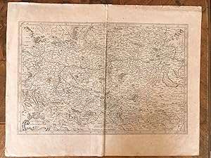
Alsatia inferior
Edité par c.1648, Amsterdam, 1648
Vendeur : Alexandre Antique Prints, Maps & Books, Toronto, ON, Canada
Membre d'association : ABAC ILAB
Evaluation du vendeur :

Carte
Etat : Good. Map of Strasbourg showing various regions, rivers, hilltops, forests and terrains. With decorative Cartouche on upper right side that features floral and fruit designs. French text on verso. Henricus Hondius II (1597 ? 16 August 1651) was a Dutch engraver, cartographer and publisher. He was born in Amsterdam, the son of the famous cartographer Jodocus Hondius who had started a map-making business in the city. In 1641 he published the Mercator-Hondius atlas. He died in Amsterdam., Size : 362x432 (mm), 14.25x17.00 (Inches), Original Outline Coloring.
-
![Image du vendeur pour Cuba Insula. [17th Century Jodocus Hondius Map of Cuba]. mis en vente par Raptis Rare Books](https://pictures.abebooks.com/inventory/md/md31336661088.jpg)
Cuba Insula. [17th Century Jodocus Hondius Map of Cuba].
Edité par c. 1630, Amsterdam, 1630
Vendeur : Raptis Rare Books, Palm Beach, FL, Etats-Unis
Evaluation du vendeur :

Rare 17th century Jodocus Hondius map of Cuba, Puerto Rico, Hispaniola and Jamaica. One page, hand-colored, the map shows the islands of Cuba, Puerto Rico, Hispaniola and Jamaica with an inset of Havana and detailed embellishments of ocean waves, sea monsters and ships. In near fine condition. An excellent example of the bold and highly detailed Mercator-Hondius style of engraving. Jodocus Hondius the Elder was one of the most prominent geographers and engravers of the late 16th and early 17th century. His work established Amsterdam as the center of cartographic publishing in the seventeenth century and one of his most successful commercial ventures was the reprinting of Mercatorâ s atlas. When he acquired the Mercator plates, he added 36 maps, many engraved by him, and released the atlas under Mercatorâ s name, helping to solidify Mercatorâ s reputation posthumously.
-
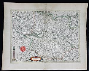
Austria Archiducatus. Per Gerardum Mercatorem. Cum Priuilegio - L' Archeduche D' Austriche. Le troisiesme Circle de l' Empire estceluy d' Austriche, auquel y a deux Ordres.
Edité par Amstelodami Sumptibus Henrici Hondij, A 1627 (Amsterdam, Henricus/Hendrik Hondius), 1627
Vendeur : Antiquariat Liber Antiqua, Krems an der Donau, Autriche
Evaluation du vendeur :
Art / Affiche / Gravure
ca. Blatt 56 x 44cm, Stich 32 x 49 cm unkolorierter Kupferstich, Blatt 56 x 44cm, Stich 32 x 49 cm, Blatt stark gebräunt, fleckig, randlädiert und am Bug an mehreren Stellen eingerissen, Rückseite mit Bleistift beschriftet, Rückseiten in Französisc,h für das Alter mittel bis gut; Wolfgang Lazius (humanistischer Gelehrter, Professor der Medizin an der Universität Wien und Leibarzt von Kaiser Ferdinand I) wird in Rücktexten mehrmalig erwähnt. la.
-
No Binding. Etat : Fine. MERCATOR, GERARD - HENRICUS HONDIUS [MAP]. Natoliae sive Asia Minor. Amsterdam: Hondius, c. 1628. 35x48 cm. Hand coloured copper engraved antique map of Antatolia. Fine ISBN: CATALOG: Maps & Engravings KEYWORDS: Map Geography Anatolia Collection Atlas - Mapbook Cartography Istanbul - Constantinople Aegean Mediterranean Black Sea.