
Montant total (1 article articles) :
Destination de la commande :

robert vaugondy d (15 résultats)
Passer aux résultats principaux de la recherche
Type d'article
- Tous les types d'articles
- Livres (11)
- Magazines & Périodiques
- Bandes dessinées
- Partitions de musique
- Art, Affiches et Gravures (1)
- Photographies
- Cartes (2)
-
Manuscrits &
Papiers anciens (1)
Etat
Reliure
Particularités
Pays
Evaluation du vendeur
-
Observations critiques sur les nouvelles dcouvertes de l'amiral de La Fuente , prsentes l'Acadmie royale des sciences, le 26 mai 1753
Edité par Hachette Livre - BNF, 2014
ISBN 10 : 2013431139ISBN 13 : 9782013431132
Livre impression ŕ la demande
PAP. Etat : New. New Book. Shipped from UK. THIS BOOK IS PRINTED ON DEMAND. Established seller since 2000.
Plus de choix d'achat de la part d'autres vendeurs sur AbeBooks
Offres neuf ŕ partir de EUR 22,31
-
Si l'applatissement de la terre peut tre rendu sensible sur les cartes et si les gographes peuvent la ngliger, sans tre taxs d'inexactitude Acadmie royale des sciences, juillet 1775 Histoire
Edité par Hachette Livre - BNF, 2018
ISBN 10 : 2019315548ISBN 13 : 9782019315542
Livre impression ŕ la demande
PAP. Etat : New. New Book. Shipped from UK. THIS BOOK IS PRINTED ON DEMAND. Established seller since 2000.
Plus de choix d'achat de la part d'autres vendeurs sur AbeBooks
Offres neuf ŕ partir de EUR 23,48
-
Memoire sur une question de geographie pratique, si l'applatissement de la terre peut etre
Edité par HACHETTE LIVRE-BNF 2018-02, 2018
ISBN 10 : 2014441359ISBN 13 : 9782014441352
Livre
PF. Etat : New.
-

Memoire sur une question de geographie pratique. Academie royale des sciences, juillet 1775
Edité par HACHETTE LIVRE-BNF 2021-10, 2021
ISBN 10 : 2329661797ISBN 13 : 9782329661797
Livre
PF. Etat : New.
-
Tablettes parisiennes. Plan de la ville et des faubourgs de Paris divise en vingt quartiers
Edité par HACHETTE LIVRE-BNF 2022-02, 2022
ISBN 10 : 2329736517ISBN 13 : 9782329736518
Livre
PF. Etat : New.
-
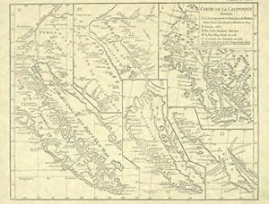
Modern Reprint of Four Early California Maps. Carte De La Californie Suivant I. la Carte manuscrite de l'Amérique de Mathieu Néron Pecci olen dresses ŕ Florence en 1604, II. Sanson 1656, III. De l'Isle Amérique Sept. 1700, IV. le Pere Kino Jesuite en 1705, V. la Société des Jésuites en 1767.
Edité par [Los Angeles, CA: ca. 1975]., 1975
Vendeur : Wittenborn Art Books, San Francisco, CA, Etats-Unis
Evaluation du vendeur :

Manuscrit / Papier ancien
Etat : Good. Modern Reprint. 8.5" x 11", Single Sheet, Very Good. Embossed with "The Heiskells" with "Merry Christmas and Happy New Year From The Heiskells" printed on one of the four maps.Provenance: Herb Yellin (1935-2014) was the highly respected publisher and founder of Lord John Press, considered by many to be one of the most important small presses of the 20th century.
-
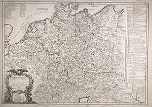
L'Empire d'Allemagne divisé en ses dix Cercles." - Deutsches Reich Deutschland Germany Österreich Böhmen Nederland Heiliges Römisches Reich Deutscher Nation
Edité par Paris, Fortin, 1778
Vendeur : Antiquariat Steffen Völkel GmbH, Seubersdorf, Allemagne
Membre d'association : ILAB VDA
Evaluation du vendeur :
Carte
Großformatige altkolorierte Kupferstich-Karte von 1778. -- Blatt-Maße: ca. 55 x 78 cm. -- in den Außenrändern etwas wasserfleckig, sonst gut erhalten. || Large old colored engraved map from 1778. -- with some waterstaining on the margins, otherwise in good condition. || Dies ist ein Original! - Kein Nachdruck! - Keine Kopie! -- This is an original! - No copy! - No reprint! Sprache: Französisch Gewicht in Gramm: 35.
-
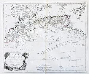
Carte de la Barbarie contenant les Royaumes de Maroc, de Fez, d'Alger, de Tunis et de Tripoli, avec les Deserts limitrophes de l'interieur de l'Afrique" - Northern Africa Morocco Tunisia Algeria Maroc Marokko Tunisien Tunesien Algerie Algerien Afrika Afrique
Edité par Venezia, Santini & Remondini, 1775
Vendeur : Antiquariat Steffen Völkel GmbH, Seubersdorf, Allemagne
Membre d'association : ILAB VDA
Evaluation du vendeur :
Carte
Großformatige altkolorierte Kupferstich-Karte von 1775 -- Blatt-Maße: ca. 52 x 74 cm. -- sehr gut erhalten. || Large old colored engraved map from 1775. -- in very good condition. || Francesco Santini was a Venetian publisher. He acquired the printing plates of Vaugondy's Atlas Universel, a commercial and cartographic success, with widespread influence on mapmakers throughout Europe. Together with his brother Paolo, he commissioned a new set of plates and reissued the atlas in 1776. In the following years, Paolo Santini assigned all his publication rights to M. Remondini, who in 1777 reissued the same atlas, but with his name. || Dies ist ein Original! - Kein Nachdruck! - Keine Kopie! -- This is an original! - No copy! - No reprint! Sprache: Französisch Gewicht in Gramm: 550.
-
No Binding. Etat : Good. 1st Edition. Dated 1752; covers the Impire of Caroli Magni; some text: "usque Marc Balticum, protenditur"." cum privilegio"'; text in Latin: map show the England, Germany, France, Spain, top of Africa, some of Turkey and more, during Caroli Magni period; folded / attached in the middle and the back it has print the number 12, so apparently this was a print/map from a book; paper size: 33 x 23in, image size: 22 x 19 in; the paper has an invisible water mark in the hand made paper; there is green borders for the Impire, Spain would have been Moslum at the time; a little rubbing and just a little foxing and a tiny spot in margins; just a little normal browning to all the map; overall the map is in GOOD COND.
-

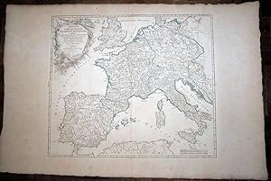
L'Europe divisee suivant l'etendue de ses principaux Etats, subdivises en leurs principales Provinces
Edité par Paris: 1738, 1738
Vendeur : Arader Galleries - AraderNYC, New York, NY, Etats-Unis
Evaluation du vendeur :
2 sheets joined (sheet size 21 6/8 x 30 inches; 18 x 27 7/8 inches to the neat line), full margins showing the plate mark. A fine engraved detailed map of Europe, the title within a nicely ornamented Louis-XV-style cartouche upper right, scale within a small sober cartouche, the left part of the map is a kind of manual which gives some information on the scientific information the map provides in political geography, natural geography and astronomic geography; with original hand color in outline (spot on the upper middle margin, vertical fold marks, a little toned at the edges). A fine and very interesting political, natural and astronomical map of Europe. Gilles Robert de Vaugondy (1688-1766), also known as Le Sieur or Monsieur Robert, and his son, Didier Robert de Vaugondy (c.1723-1786), were leading mapmakers in France during the 18th century. In 1757, they published The 'Atlas Universel' in which they integrated older sources with more modern maps. This dialogue between old and new is also suitable for this map, as it is originally made by Nicholas Sanson (1600-1667), who was the founder of the French school of cartography.
-
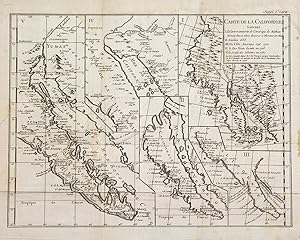
Carte De La Californie Suivant 1. La Carte Manuscrite de l'Amerique de Mathieu NČron Pecci olen dresses a Florence en 1604.
Edité par Paris, 1779
Vendeur : libreria antiquaria perini Sas di Perini, Verona, VR, Italie
Membre d'association : ALAI ILAB
Evaluation du vendeur :
Art / Affiche / Gravure
Copper engraving, mm 292x387. From Denis Diderot's "Encyclopedie"; shows California and the Pacific Northwest drawn firstly by Mathieu NČron Pecci in Florence in 1604, then by Nicolas Sanson in 1656, Guillaume de L'Isle in 1700 and by the Jesuit Father Kino in 1705 and finally the Society of Jesuits in 1767. The five inset charts on this sheet reveal how little was known of the coast of California in the 17th and early 18th centuries, from the time when California was believed to be an island in Sanson's map of 1656, to the surveys of the Jesuits in 1705-1767, which finally disproved the island theory. However, until Capt. James Cook and George Vancouver brought back detailed charts of North America's west coast, the European cartographers continued to portray the coast from Cabo San Lucas at the southern tip of the Baja Peninsula to Cape Mendocino and Cape Blanco in present day Oregon, in entirely speculative topography. Robert de Vaugondy, who engraved and published this compilation of sections of early maps, intended the overall sheet to be a history of the mapping of California and it was included in the Supplement to Diderot's "Encyclopie" in 1779. Very good condition with original folds Nr.cat: Cod. 2380.
-
S.l.,s.n., 1774. 75,7 x 162,2 cm [et] S.l., s.n., s.d. 54 x 55,5 cm [et] Paris, chez l'auteur, octobre 1756. 57,5 x 73 cm, chemise et étui cartonnés (rousseurs et taches, une déchirure et un petit manque ŕ la carte grecque,étui défraîchi). Carte représentant la partie Nord de l'Empire ottoman, centrée sur la Mer noire. Elle est imprimée sur papier et collée sur deux pans de toile brune. Elle a été gravée par J. Arrivet. [et] Carte de la partie occidentale de la Turquie comprenant également la péninsule grecque jusqu'ŕ la Hongrie et la partie orientale de la péninsule italienne. Elle est rehaussée de couleurs, imprimée sur papier et collée sur un pan de toile brune. Elle a été gravée par Barričre. [et] Carte représentant la Grčce et ses îles. Elle est imprimée sur papier et collée sur un pan de toile brune. Voir photographie(s) / See picture(s).

![Image du vendeur pour Carte de la partie septentrionale de l'Empire ottoman [et] Turquie européenne [et] Les Côtes de la Grčce et l'Archipel mis en vente par L'Ancienne Librairie](https://pictures.abebooks.com/inventory/md/md31683118146.jpg)