
Montant total (1 article articles) :
Destination de la commande :

strabo, Edition originale (15 résultats)
Passer aux résultats principaux de la recherche
Type d'article
- Tous les types d'articles
- Livres (15)
- Magazines & Périodiques
- Bandes dessinées
- Partitions de musique
- Art, Affiches et Gravures
- Photographies
- Cartes
-
Manuscrits &
Papiers anciens
Etat
- Tous
- Neuf
- Ancien ou d'occasion
Reliure
Particularités
- Edition originale
- Signé
- Jaquette (1)
- Avec images (10)
- Sans impression ŕ la demande
Pays
Evaluation du vendeur
-
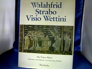
Visio Wettini : lat.-dt. = Die Vision Wettis. Walahfrid Strabo. Übers., Einf. u. Erl. von Hermann Knittel.
Edité par Sigmaringen : Thorbecke, 1986
ISBN 10 : 3799540806ISBN 13 : 9783799540803
Vendeur : Antiquariat Michael Solder, Münster, NRW, Allemagne
Membre d'association : ILAB VDA
Evaluation du vendeur :

Livre Edition originale
Etat : Gut. 1. Auflage. 120 S. Mit 8 Abb. Gutes Exemplar. Sprache: Deutsch Gewicht in Gramm: 500 Gr.-8°. Originalleineneinband mit Schutzumschlag.
-

Visio Wettini : lat.-dt. = Die Vision Wettis. Walahfrid Strabo. Übers., Einführung und Erläuterungen von Hermann Knittel.
Edité par Sigmaringen : Thorbecke,, 1986
ISBN 10 : 3799540806ISBN 13 : 9783799540803
Livre Edition originale
Gr.-8°, Gewebe. EA. 120 S. mit s.-w. u. farb. Abb. Sprache: Deutsch Gewicht in Gramm: 370.
-
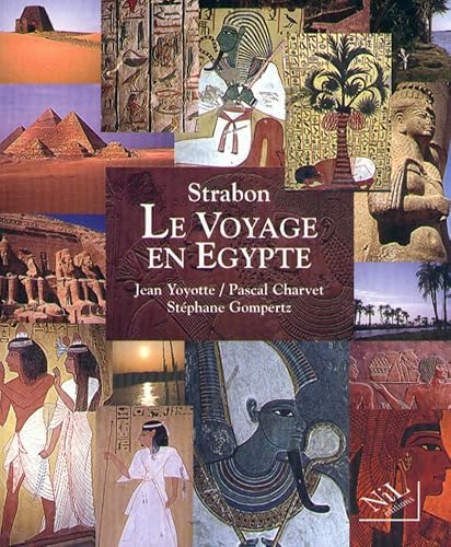
Le voyage en Egypte: Un regard romain (Le Cabinet de curiosite?s) (French Edition)
Edité par NiL Editions, 1997
ISBN 10 : 2841110680ISBN 13 : 9782841110681
Vendeur : Prior Books Ltd, Cheltenham, Royaume-Uni
Membre d'association : ABA ILAB PBFA
Evaluation du vendeur :
Livre Edition originale
Paperback. Etat : Very Good. First Edition. Original stiff card covers; in very good shape; no tears, chips or creases, just mildly rubbed and edge-worn. Contents sound and clean; no pen-marks. Not from a library so no such stamps or labels.
-

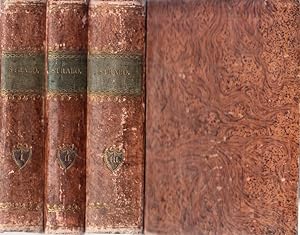
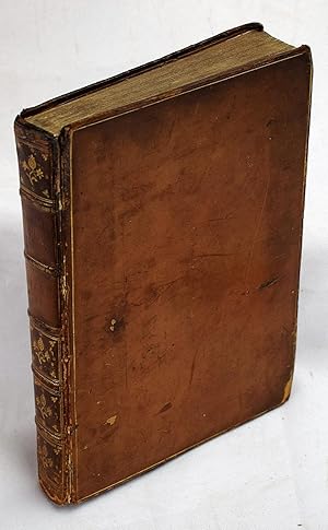
Strabo`s Geographie. Erste Abtheilung, 1.-6. Buch. Übersetzt von Karl Kärcher.
Edité par Stuttgart, Metzler, 1830-1831., 1830
Vendeur : Buch & Cafe Antiquarius, Bonn, NRW, Allemagne
Membre d'association : GIAQ
Evaluation du vendeur :
Livre Edition originale
12°, Leinenband der Zeit. 1. Aufl. 538 S. Seiten gebräunt oder etwas fleckig, sonst schönes Ex. Sprache: Deutsch Gewicht in Gramm: 0.
-
Strabonis rerum geographicum - ad optimorum librorum fidem. Libri XVII. Tomus I, II et III. Editio stereotypa.
Edité par Tauchnitz, Leipzig 1819 (Lipsiae, ex officina car. Tauchnitii)., 1819
Vendeur : Antiquariat Carl Wegner, Berlin, B, Allemagne
Membre d'association : GIAQ
Evaluation du vendeur :
Edition originale
Hardcover. 13,7 x 9,2 cm. Drei uniforme Pappbände der Zeit mit grünen Rückenschildern und grünem Dreiseitenschnitt. 2 Bll., 407 Seiten (Buch 1 - 5) / 2 Bll., 467 Seiten (Buch 6-11) / 2 Bll., 503 Seiten (Buch 12 - 17) in altgriechischer Sprache. Die Bände leicht berieben, die Ecken gering bestoßen. Die Innenteile nur sehr leicht gebräunt, die Bände insgesamt sauber, die Bimdungen fest. Guter Gesamtzustand. -- Bitte Portokosten außerhalb EU erfragen! / Please ask for postage costs outside EU! / S ' il vous plait demander des frais de port en dehors de l ' UE! -- Herzlichen Dank für Ihre Bestellung! Geog.
-
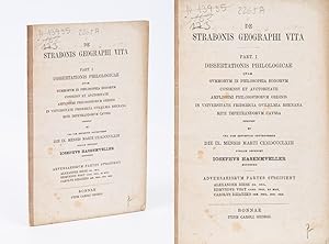
De Strabonis Geographi Vita. Part I.
Edité par Bonn, Carl Georgi., 1863
Vendeur : Inanna Rare Books Ltd., Skibbereen, CORK, Irlande
Evaluation du vendeur :
Livre Edition originale
8°. 37 Seiten. Softcover / Titelbroschur. Sehr guter Zustand. Es handelt sich hier um die originale Doktorarbeit. Strabo (Strábon; 64 or 63 BC c. AD 24) was a Greek geographer, philosopher, and historian who lived in Asia Minor during the transitional period of the Roman Republic into the Roman Empire. Strabo is most notable for his work Geographica ("Geography"), which presented a descriptive history of people and places from different regions of the world known to his era. Map of Europe according to Strabo. Although the Geographica was rarely utilized in its contemporary antiquity, a multitude of copies survived throughout the Byzantine Empire. It first appeared in Western Europe in Rome as a Latin translation issued around 1469. The first Greek edition was published in 1516 in Venice. Isaac Casaubon, classical scholar and editor of Greek texts, provided the first critical edition in 1587. Although Strabo cited the antique Greek astronomers Eratosthenes and Hipparchus, acknowledging their astronomical and mathematical efforts towards geography, he claimed that a descriptive approach was more practical, such that his works were designed for statesmen who were more anthropologically than numerically concerned with the character of countries and regions. As such, Geographica provides a valuable source of information on the ancient world, especially when this information is corroborated by other sources. He traveled extensively, as he says: "Westward I have journeyed to the parts of Etruria opposite Sardinia; towards the south from the Euxine to the borders of Ethiopia; and perhaps not one of those who have written geographies has visited more places than I have between those limits." We do not know when he wrote the Geography, but we know that he spent a lot of time in the famous library taking notes from his sources and his "the works of his predecessors" are most likely to have been noted at the library there. A first edition was published in 7 BC and a final edition no later than 23 AD, in the last year of Strabo's life. The Geography, unfortunately, had an infinitesimal influence in his lifetime. It took about five years for scholars to give him a credit and for it to become a standard. In his last book of Geographica, he wrote quite extensively about the thriving port city of Alexandria. He emphasized that the harbor was well-encompassed by the embankments and that the shore was so deep-watered that even the largest ships could traverse. These ships were sent out to India, Ethiopia to supply them with products. Strabo juxtaposes Dichaiarchia (Naples- one of the largest ports in Europe) and Alexandria ports and says that the ships in Alexandria were clearly bigger. Thus, freight transporting and shipping were essential to foreign trade in products from all over the world, suggesting a highly developed local economy at that time. Strabo also describes the city itself. According to him, there were a lot of beautiful public parks and the city was reticulated with perfectly designed streets that were wide enough for chariots and horsemen. "Two of these are exceeding broad, over a plethron in breadth, and cut one another at right angles. All the buildings are connected one with another, and these also with what are beyond it." Hence, the architecture was also developed in Egypt. (Wikipedia) Sprache: latin.
-
Des Strabo eines alten stoischen Weltweisen aus der Stadt Amasia gebürtig allgemeine Erdbeschreibung. Abraham Jacob Penzel hat sie aus dem Griechischen übersetzt. 4 Bände.
Edité par Lemgo, Meyer, 1775-1777., 1777
Vendeur : Manfred Nosbuesch, Kuchenheim, Allemagne
Membre d'association : ILAB VDA
Evaluation du vendeur :

Edition originale
Mit gest. Faltkarte. Etwas spätere Halblederbände mit Rückenschild und -vergoldung. Erste deutsche Ausgabe. - Bände I und II: Europa. III: Asien. IV: Asien und Afrika. - Karte: "Karte von dem bewohnten Theil der Erde, so weit er den Griechen bekannt war, nach dem Eratosthenes". - Exlibris auf Innendeckel. - Durchgehend etwas gebräunt und teils fleckig, vereinzelte alte Anstreichungen, Karte mit Braunfleck und alter Annotation im Rand.
-
La prima parte della Geografia di Strabone, di greco tradotta in volgare italiano da M. Alfonso Buonacciuoli . con due copiosissime tauole l'una de' nomi antichi & moderni, l'altra di tutti i nomi, & cose notabili, che in questo libro si contengono.
Edité par Venice: Francesco Senese, 1562
Vendeur : Sequitur Books, Boonsboro, MD, Etats-Unis
Membre d'association : IOBA
Evaluation du vendeur :
Livre Edition originale
Hardcover. Etat : Good. First Edition. [The first 10 books of Strabo's Geographica] First Italian ed (and first not in Latin). Strabo's work is considered to be the first work of political and ethical geography. The Italian humanist, Alfonso Bonacciuoli (of Ferrara), translated Stabo's work while under the patronage of the Gonzaga family. Small quarto. Bound in later, gilt-ruled calf. Var. B: [36], 220 [i.e. 200], [2] c. Typographical vignette on the title page of a female figure within an oval resting on a cornucopia. Damp staining, mostly to first few pages. Front board detaching. Refs: Adams S, 1909; STC Italian 648; Schweiger 305. Gamba 1663: "Quantunque siasi fatto questo volgarizzamento dal greco su testi imperfetti. e tenuto tuttavia in pregio, e s'ebbe anche de' nostri giorni dal celebre grecista Coray lode di fedelta.". Octagonal armorial book plate of Thomas Falconer, "Vive ut viva." Book plate contains "an angel kneeling and praying between two boughs of laurel" engraved by T. Moring. Ref: Heraldic bookplates collected by David H Graham, and commissioned by people of surnames beginning with F. 1700-1800s.
-
![Image du vendeur pour Strabonis Geographicorum lib. XVII. Olim, ut putatur, a Guarino Veronensi ac Gregorio Trifernate latinitate donati, iam denuo a Conrado Heresbachio LL. doctore, Principisque Iuliacensis consiliario ad fidem Graeci exemplaris authorumque, qui huc facere videbantur, recogniti, ac plerisque locis deintegro versi. Item Epitomae eorundem decem & septem de Geographia librorum, nunc primum de Graeco sermone in Latinum conversae, Hieronymo Gemusaeo [.]. mis en vente par Versandantiquariat Wolfgang Friebes](https://pictures.abebooks.com/inventory/md/md22851293470.jpg)
Strabonis Geographicorum lib. XVII. Olim, ut putatur, a Guarino Veronensi ac Gregorio Trifernate latinitate donati, iam denuo a Conrado Heresbachio LL. doctore, Principisque Iuliacensis consiliario ad fidem Graeci exemplaris authorumque, qui huc facere videbantur, recogniti, ac plerisque locis deintegro versi. Item Epitomae eorundem decem & septem de Geographia librorum, nunc primum de Graeco sermone in Latinum conversae, Hieronymo Gemusaeo [.].
Edité par Basel, Johann Walder, 1539., 1539
Vendeur : Versandantiquariat Wolfgang Friebes, Graz, Autriche
Membre d'association : ILAB VDAO
Evaluation du vendeur :
Edition originale
Etat : 0. Erste Ausgabe der Bearbeitung Conrad Heresbachs, der der Übersetzung des Werkes Strabos in der Fassung von 1523 neu eine eigene Übersetzung einer bis dahin ungedruckten, alten griechischen Epitome, einer Kurzfassung der 17 Bücher vorangestellt" hat (Hieronymus). - Einband berieben, bestoßen u. etw. fleckig. Ecken u. Rückendeckel m. (Bezugs-)Fehlstellen. Rückenkanten angebrochen. Eine Schließe fehlt, eine defekt. Innendeckel m. altem Eintrag u. mont. Katalogausschnitt. Vorderes Vorsatzblatt fehlt. Titel m. zwei Besitzvermerken. Zu Beginn u. gegen Ende m. Randläsuren u. Wurmspuren. Vereinzelt alte Unterstreichungen. Mod. Exlibris a. der weißen Vorderseite des letzten Blattes. Vereinzelt (nur Titel etw. stärker) fleckig. - VD16, S 9347; Schweiger I, 304; Hieronymus 288; Adams S 1904; Griechischer Geist aus Basler Pressen, 288; Hoffmann III,457f.; Ebert 21826. la Gewicht in Gramm: 4000 Fol. Titel m. Holzschn.-Bordüre u. -Druckermarke. Mit tlw. figürl. Holzschn.-Vignetten u. -Initialen (Kinderalphabet). Das letzte Blatt m. einer Holzschn.-Druckermarke (Papagei mit Olivenzweig). 44 Bll., 549 S., 13 Bll., Blindgepr. Schweinsldr.-Bd. d. Zt. a. 4 Bünden.
-
Rerum geographicarum libri XVII graece et latine [.]. Annotationes, e tabulas geographicas adjecit Thomas Falconer [.], subjiciuntur chrestomathie graece et latine. Tom. I [-II].
Edité par Oxonii, e Typographeo Clarendoniano, 1807
Vendeur : Gabriele Maspero Libri Antichi, Como, Italie
Membre d'association : ALAI ILAB
Evaluation du vendeur :
Edition originale
Etat : Like New. 2 volumi in-folio imperiale (cm. 44), buone e solide legature coeve in m. pelle e angoli con titolo, filetti e fregi ai dorsi (antica etichetta applicata), piatti marmorizzati; pp. [4], VIII, 24, 643, [1 b.]; [4], 645-1333, [81], 4 in ottimo stato, ad ampi margini e in barbe, testo su due colonne (latino e greco), fregi e qualche silografia n.t., con 1 tavola in rame in antiporta f.t. e tutte le 17 grandi carte geografiche in rame ripiegate f.t. (tra gli incisori Guillaume de la Haye e Thomas Conder). Prima edizione del famigerato e raro Strabone d'Oxford, monumentale pubblicazione curata dal Falconer (1772-1839) che collazionň molteplici edizioni antiche in un lavoro di enorme erudizione giŕ iniziato anni prima dallo zio omonimo (1738-1792) allo scopo di editare un capolavoro. Paradossalmente l'Edinb. Review e il Class. Journal criticarono l'officina clarendoniana per gli errori tipografici [Graesse VI, 506]. Cfr. Hoffmann III, 455; Dibdin II, 435. Ottimo esemplare. (SM5).
-
Rerum geographicarum libri XVII.Paris, typis Regiis [Fédéric Morel], 1620. 2 parts in 1 volume. Folio. With title-page printed in red and black with the engraved coat of arms of Louis XIII, and several woodcut initials, head- and tailpieces. Contemporary gold-tooled parchment, gilt edges.
Vendeur : Antiquariaat FORUM BV, Houten, Pays-Bas
Membre d'association : ILAB NVVA
Evaluation du vendeur :
Edition originale
[12], 843, [112]; [4], 282, [8] pp.Enlarged and corrected second edition of Strabo's Geographika including the notes by the French scholar Isaac Casaubon (1559-1614): one of the earliest and most important scientific treatises on historical geography. It contains the Greek text together with the Latin translation by Wilhelm Xylander (1532-1576) and is followed by Casaubon's notes. "Casaubon was but 28 years of age when he published his first celebrated edition of Strabo [in 1587]. The [present] second edition, published by Frederick Morel at Paris, is much more accurate and splendid than the first" (Dibdin). Together with the works of Ptolemy and Solinus, Strabo's Geographika constitutes the first attempt at a unified treatise of geographical knowledge. It was first printed in 1516 by the Aldine press at Venice. Strabo visited Egypt and sailed up the Nile in 25 BC. Books 15 and 16 are devoted entirely to the Orient in general and Arabia in particular, while the final book discusses Egypt and Libya.With two bookplates on paste-down. Title-page browned, with the lower outer corner torn off, a single minute wormhole in the gutter margin through the first half of the book, otherwise in very good condition. Binding rubbed and front hinge partly split, but otherwise good. An essential source for Europe s earliest relations with the Middle East.l Brunet V, col. 554; Dibdin II, p. 433; Graesse VII, p. 604.
-
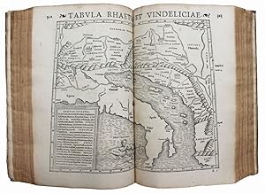
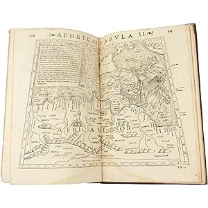
Geografikon bibloi epta kai deka. Rerum geographicum libri septemdecim
Edité par Henrichum Petri, [1571], Basel, 1571
Vendeur : Hugues de Latude, Villefranche de Lauragais, France
Membre d'association : ILAB
Evaluation du vendeur :
Edition originale
*** Premičre édition illustrée et premičre édition des commentaires et de la traduction latine de l'humaniste Xylander, professeur ŕ l'université d'Heidelberg. Edition recherchée de la "Géographie" de Strabon, pour la correction de son texte et son illustration. Elle comprend 8 cartes dans le texte d'aprčs Mercator et 27 cartes sur double-page, qui sont les męmes bois gravés par Sébastien Munster, pour son édition de Ptolémé (1540). L'humaniste Guilielmus Xylander (1532 - 1576) a été nommé professeur de grec de l'Université de Heidelberg ŕ l'âge de vingt-cinq ans. Il édita et traduisit de nombreuses Ĺ"uvres de l'Antiquité, dont les "Eléments" d'Euclide, et apporta d'importantes contributions ŕ la diffusion des mathématiques. Texte grec et latin sur deux colonnes. Marque de l'imprimeur sur le titre et le dernier feuillet. Bel exemplaire dans une élégante reliure de l'époque. Adams S-1907. USTC 694731. *** In-folio de (116), 977, (3) pp. Vélin, dos ŕ nerfs, encadrement ŕ froid avec fleurons au coins et grands fleurons dorés au centre. (Reliure de l'époque.) - - - - - - - - - - - - - - - - - - - - - - - - - - - - - - - - - - - - - - - - - - - - - - - - - - - - - - - - - - - - - - - - - - - - * First illustrated edition and first edition of the commentary and the Latin translation by Guilielmus Xylander, professor at the University of Heidelberg. Xylander's edition of Strabo. Illustrated by 8 maps in text after Mercator and 27 double-page woodcut maps by Sebastian Münster, used in his edition of Ptolemy. - -.
-
Rerum Geographicarum libri septemdecim. A Guilielmo Xylandro Augusta.
Edité par Basel, ex officina Heinrich Petri, 1571
Vendeur : Bruce Marshall Rare Books, Cheltenham, Royaume-Uni
Membre d'association : ABA ILAB
Evaluation du vendeur :
Livre Edition originale
Hardcover. Etat : Very Good. 1st Edition. Basel, ex officina Heinrich Petri, August 1571, Attractive contemporary calf binding, with gilt frame enclosing gilt device, gilt fleurons, spine gilt with central gilt arabesque designs, gilt gauffered edges. A complete copy of this scarce work, double-column Greek and Latin text, woodcut printer's device on title and another on verso of otherwise blank final leaf, with 27 double-page woodcut maps by Sebastian Muenster and 7 smaller maps in text, woodcut initials.
A very good copy in a contemporary binding of this important geographical survey, edited by Xylander.
 FIRST ILLUSTRATED EDITION of Strabo's work and first edition of the commentary and Latin translation by the German humanist Guilielmus Xylander, the Greekizing pseudonym of Wilhelm Holtzmann (1532-1576), professor at the University of Heidelberg. The maps shown here are the work of the cartographer Sebastian Münster, which he engraved for his edition of Ptolemy's "Geography" (Basel, Heinrich Petri, 1540). Strabo's vast compilation is drawn in large from indirect sources, but very rich in historical, geographical, political, economic and religious descriptions of all known peoples. It opens with two introductory geographical treatises, Books III-X deal with Europe with particular regard naturally to Greece (whose paper is repeated twice, while almost all the small descritions in the text represent Greek islands); books XI-XVI concern Asia; the seventeenth finally Egypt and northern Africa. The Greek text of Strabo was printed for the first time by Aldo in 1516, while the Latin text translated by Guarino Veronese appeared in editio princeps in 1469. A Greek historian and geographer born in Amaseia (Ponto), Strabo was a pupil of the philosopher Senarco, of grammarian Aristodemus and the geographer Tyrannion. He arrived in Rome in 44 BC to remain there until 31 AD He travelled extensively in Egypt, Ethiopia and Asia Minor, collecting information for this important geographical work. Adams S1907; Phillips (Atlases) 3390; Nordenskiold 30, 21.
-
Strabonis Rerum Geographicarum Libri XVII. Isaacus Casabonus recensuit, summoque studio & diligentia, ope etiam veterum codicum, emendavit, ac Commentariis illustravit. Accessit & Tabula Orbis totius descriptionem complectens. Adiecta est etiam Guilielmi Xylandri Augustani Latina versio, cum necessariis Indicibus. [With ] Isaaci Casauboni Commentarius et Castigationes ad lib. Strabonis Geograph. XVII. S. l. First edition with the Mercator World Map .
Edité par Geneva: Eustathius Vignon., 1587
Vendeur : Wittenborn Art Books, San Francisco, CA, Etats-Unis
Evaluation du vendeur :
Edition originale
Etat : Good. Folio. 34 x 21 cm. Original contemporary stiff vellum with 6 raised bands. [2], viii, 602, [10], 224pp. Two columns printed in Latin and Greek in the first part and Latin only in the second part. Waterstain in the lower right corner throughout. The map is bound in front of page 1 and is in fine and fresh condition.This unique map was first printed as part of Isaac Casaubon's edition of Strabo's Geographia in 1587. In this, the first printing there are columns of text underneath rhe map with the heading, ?Lectori S. P.? In later editions the map was included in the well known Mercator atlas, which Rumold compiled. In 1603, the plate developed cracks in the top edge of the plate; two distinct cracks can be seen in the title.The preeminent example of Rumold Mercator's map of the world, first printed in this edition in Geneva in 1587. It is based on Gerard Mercator's celebrated 1569 world map and was made while Gerard was still alive (1512- 1594). This is the only collectible world map with direct input from Gerard Mercator, the greatest geographer of his era. Both his 1538 and 1569 world maps are unobtainable rarities.The present work is a reduced version of the 1569 wall map of the world, on which the revolutionary Mercator Projection was introduced. This edition makes the map into a double-hemisphere format, rather than the projection style.To the left is the western hemisphere. The prominent bulge in South America, a characteristic introduced by Gerard Mercator and evident on his 1569 world map, has been retained here. Tierra del Fuego forms part of a gigantic southern continent that continues in the eastern hemisphere. At the north pole, two of the four islands that Gerard Mercator thought surrounded the pole are evident. There is also a suggestion of a Northwest Passage via the Straits of Anian.Isaac Casaubon, (1559, Geneva ?died July 1, 1614, London). French classical scholar and theologian who was one of the leading scholars of the era.He was born in Geneva on 18th February 1559, a son of Huguenot parents Arnaud and Jeanne. He was educated at the university in his home town and taught Greek there. His first wife was Marie Prolyst but she and their daughter died. In 1586 in Geneva he married Florence, daughter of Henry Estienne and they had seventeen children, of whom about half did not survive infancy. His first major published work was on the Greek geographer Strabo and many other works followed. The invitation to come to England seems to have come from Richard Bancroft, Archbishop of Canterbury. Isaac was later made a prebendary of Canterbury but died in London on 1st July 1614.References: This first edition not in OCLC. Shirley, The Mapping of the World - Early Printed World Maps 1472 - 1700, Nr. 157; van der Krogt, Koeman's Atlantes Neerlandici, Vol. I, 0001:1A; Adams S-1908; Graesse VI:505. (Map) Koeman Me12; Moreland & Bannister p. 243; Shirley 157; Wagner Northwest Coast 146 . In-folio, reliure de l'époque vélin, dos ŕ 6 nerfs, titre ŕ l'encre dans le caisson de tęte. Qq. taches, petites déchirures (nerfs et coiffe inférieure), coins usés. (8)-602-(2 bl.)-(8)-223 pp. et planisphčre ŕ double page rempliée. Trace de mouillure dans la partie inférieure droite sur tout l'ouvrage, marquée sur le premier quart puis s'amenuisant et s'estompant jusqu'ŕ la fin du volume. Planisphčre en belle condition (mouillure ŕ peine visible, pas de déchirure, impression contrastée). Exemplaire complet des deux pages de titre gravées sur bois ŕ décor identique de cariatides soutenant une couronne et de la planisphčre (Orbis Terrae Compendiosa Descriptio) gravée par Rumold Mercator d'aprčs la carte de son pčre Gérard Mercator et légendée en latin.Expertise by Christine CHATON Expertise en livres anciens et modernes (C.N.E.S.), 17100 SAINTES.
-
Strabonis Rerum Geographicarum Libri XVII. Isaacus Casaubonis Recensuit, Summoque Studio & Diligentia, Ope Etiam Veterum Codicum, Emendauit, Ac Commentariis Illustrauit.
Edité par Eustathius Vignon, Geneva, 1587
Vendeur : Arader Galleries - AraderNYC, New York, NY, Etats-Unis
Evaluation du vendeur :
Edition originale
Two parts in one, volume. Folio (13 4/8 x 8 4/8 inches). Titles within historiated woodcut borders, printed in Greek and Latin in double columns, engraved double-page double-hemispherical world map: Mercator's "Orbis Terrae Compendiosa Descriptio", Geneva 1587 (13 Ľ x 20 Ľ inches) (supplied, small marginal tear just affecting the image repaired on verso), (some pale marginal dampstains, and one or two wormstracks). 19th-century red paneled morocco antique, spine in five compartments with four raised bands, an 18th-century morocco lettering piece in one (extremities, front paste-down removed, endpapers stained). Provenance: Contemporary marginal annotations to Casaubon's commentary, and a leaf of manuscript notes at the end. First edition of Isaac Casaubon's famous edition of Strabo's "Geography", one of the earliest and most important scientific treatises of historical geography, containing the FIRST APPEARANCE OF MERCATOR'S CELEBRATED AND ONLY AVAILABLE WORLD MAP "Orbis Terrae Compendiosa Descriptio" Geneva 1587. This variant without text on the verso and with Latin text in the bottom margin. "Gerard Mercator's great world map of 1569 was condensed into double hemispherical form by his son Rumold. The engraving is a model of clarity and neatness, with typical cursive flourishes to the lettering of the sea names." (Shirley). This map was later incorporated in Mercator's influential atlas of 1595. Adams S-1908; Graesse VI:505. (Map) Koeman Me12; Moreland & Bannister p. 243; Shirley 157; Wagner Northwest Coast 146.

![Image du vendeur pour Rerum geographicarum libri XVII graece et latine [.]. Annotationes, e tabulas geographicas adjecit Thomas Falconer [.], subjiciuntur chrestomathie graece et latine. Tom. I [-II]. mis en vente par Gabriele Maspero Libri Antichi](https://pictures.abebooks.com/inventory/md/md10631403557.jpg)
![Image du vendeur pour Rerum geographicarum libri XVII.Paris, typis Regiis [Fédéric Morel], 1620. 2 parts in 1 volume. Folio. With title-page printed in red and black with the engraved coat of arms of Louis XIII, and several woodcut initials, head- and tailpieces. Contemporary gold-tooled parchment, gilt edges. mis en vente par Antiquariaat FORUM BV](https://pictures.abebooks.com/inventory/md/md30605211647.jpg)
![Image du vendeur pour Strabonis Rerum Geographicarum Libri XVII. Isaacus Casabonus recensuit, summoque studio & diligentia, ope etiam veterum codicum, emendavit, ac Commentariis illustravit. Accessit & Tabula Orbis totius descriptionem complectens. Adiecta est etiam Guilielmi Xylandri Augustani Latina versio, cum necessariis Indicibus. [With ] Isaaci Casauboni Commentarius et Castigationes ad lib. Strabonis Geograph. XVII. S. l. First edition with the Mercator World Map . mis en vente par Wittenborn Art Books](https://pictures.abebooks.com/inventory/md/md30723499184.jpg)