
Montant total (1 article articles) :
Destination de la commande :

universal cyclopaedia atlas adams charles (44 résultats)
Passer aux résultats principaux de la recherche
Type d'article
- Tous les types d'articles
- Livres (44)
- Magazines & Périodiques
- Bandes dessinées
- Partitions de musique
- Art, Affiches et Gravures
- Photographies
- Cartes
-
Manuscrits &
Papiers anciens
Etat
- Tous
- Neuf
- Ancien ou d'occasion
Reliure
- Toutes
- Couverture rigide
- Couverture souple
Particularités
- Edition originale
- Signé
- Jaquette
- Avec images
- Sans impression ŕ la demande
Pays
Evaluation du vendeur
-
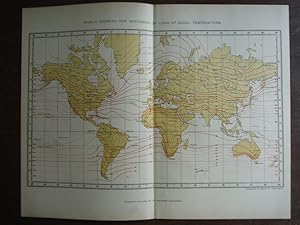
Universal Cyclopaedia and Atlas Map Map of the World Showing the Isotherms or Lines of Equal Temperature- Original (1902)
Edité par D. Appleton and Company, 1902
Vendeur : Imperial Books and Collectibles, Wauwatosa, WI, Etats-Unis
Evaluation du vendeur :

No Binding. Etat : Fine. This rare colored engraved Map of the World Showing the Isotherms or Lines of Equal Temperature, drawn and prepared by Mark W. Harrington, is from Volume III of the 1902 edition the highly acclaimed Universal Cyclopaedia and Atlas. Plate size: 8" x 13" (20 x 33 cm); Condition: Fine; Central fold, as issued. Narrow side margins. All items carefully packed to avoid damage from moisture and rough handling.
-
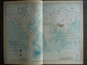
Universal Cyclopaedia and Atlas Map of Land Altitudes and Sea Depths Throughout the World- Original (1902)
Edité par D. Appleton and Company, 1902
Vendeur : Imperial Books and Collectibles, Wauwatosa, WI, Etats-Unis
Evaluation du vendeur :
No Binding. Etat : Fine. This rare original hand colored map of Land Altitudes and Sea Depths Throughout the World is from Volume III of the 1902 edition of the acclaimed Universal Cyclopaedia and Atlas by D. Appleton and Company. Plate size: - 9-1/2" x 11 1/2" (24 x 29 cm); Margins Min 1/2 in (1.2 cm). Condition: Fine; Central fold, as issued. All items carefully packed to avoid damage from moisture and rough handling.
-
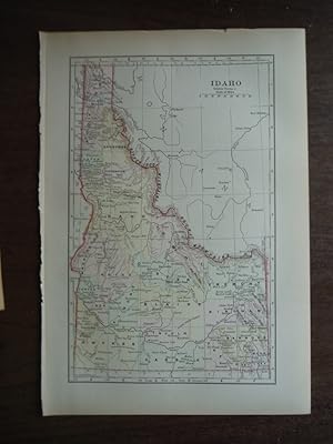
Universal Cyclopaedia and Atlas Map of Idaho Original (1902)
Edité par D. Appleton and Company, 1902
Vendeur : Imperial Books and Collectibles, Wauwatosa, WI, Etats-Unis
Evaluation du vendeur :
No Binding. Etat : Fine. This rare original hand colored map of Idaho is from Volume VI of the 1902 edition of the acclaimed Universal Cyclopaedia and Atlas by D. Appleton and Company. Counties are distinguished by color. Cities, towns, roads and rail lines are clearly depicted. Plate size: - 9" x 5 1/2 " (23 x 14 cm). Margins: - Min 1/2in (1.2cm). Condition: Fine All items carefully packed to avoid damage from moisture and rough handling.
-
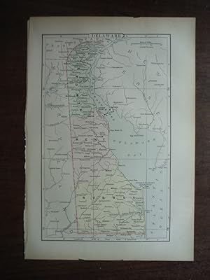
Universal Cyclopaedia and Atlas Map of Delaware Original (1902)
Edité par D. Appleton and Company, 1902
Vendeur : Imperial Books and Collectibles, Wauwatosa, WI, Etats-Unis
Evaluation du vendeur :
No Binding. Etat : Fine. This rare original hand colored map of Delaware is from Volume III of the 1902 edition of the acclaimed Universal Cyclopaedia and Atlas by D. Appleton and Company. Counties are distinguished by color. Cities, towns, roads and rail lines are clearly depicted. Plate size: - 9" x 6 " (23 x 15 cm). Margins: - Min 1/2in (1.2cm). Condition: Fine; small tear at edge not impacting plate. All items carefully packed to avoid damage from moisture and rough handling.
-
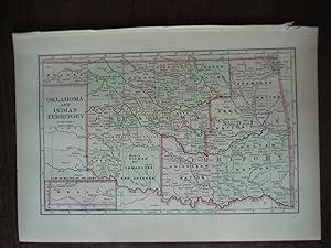
Universal Cyclopaedia and Atlas Map of Oklahoma and Indian Territory - Original (1902)
Edité par D. Appleton and Company, 1902
Vendeur : Imperial Books and Collectibles, Wauwatosa, WI, Etats-Unis
Evaluation du vendeur :
No Binding. Etat : Fine. This rare original hand colored map of Oklahoma and Indian Territory is from Volume VI of the 1902 edition of the acclaimed Universal Cyclopaedia and Atlas by D. Appleton and Company. Counties are distinguished by color. Cities, towns, roads and rail lines are clearly depicted. Plate size: - 6" x 9 " (15 x 23 cm). Margins: - Min 1/2 in (1.2cm). Condition: Fine All items carefully packed to avoid damage from moisture and rough handling.
-
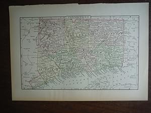
Universal Cyclopaedia and Atlas Map of Connecticut - Original (1902)
Edité par D. Appleton and Company, 1902
Vendeur : Imperial Books and Collectibles, Wauwatosa, WI, Etats-Unis
Evaluation du vendeur :
No Binding. Etat : Fine. This rare original hand colored map of Connecticut is from Volume IiI of the 1902 edition of the acclaimed Universal Cyclopaedia and Atlas by D. Appleton and Company. Counties are distinguished by color. Cities, towns, roads and rail lines are clearly depicted. Plate size: - 6" x 9 " (15 x 23 cm). Margins: - Min 1/2 in (1.2cm). Condition: Fine All items carefully packed to avoid damage from moisture and rough handling.
-
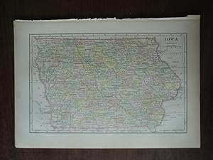
Universal Cyclopaedia and Atlas Map of Iowa - Original (1902)
Edité par D. Appleton and Company, 1902
Vendeur : Imperial Books and Collectibles, Wauwatosa, WI, Etats-Unis
Evaluation du vendeur :
No Binding. Etat : Fine. This rare original hand colored map of Iowa is from Volume VI of the 1902 edition of the acclaimed Universal Cyclopaedia and Atlas by D. Appleton and Company. Counties are distinguished by color. Cities, towns, roads and rail lines are clearly depicted. Plate size: - 6" x 9 " (15 x 23 cm). Margins: - Min 1/2 in (1.2cm). Condition: Fine All items carefully packed to avoid damage from moisture and rough handling.
-
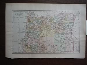
Universal Cyclopaedia and Atlas Map of Oregon Original (1902)
Edité par D. Appleton and Company, 1902
Vendeur : Imperial Books and Collectibles, Wauwatosa, WI, Etats-Unis
Evaluation du vendeur :
No Binding. Etat : Fine. This rare original hand colored map of Oregon is from Volume IX of the 1902 edition of the acclaimed Universal Cyclopaedia and Atlas by D. Appleton and Company. Counties are distinguished by color. Cities, towns, roads and rail lines are clearly depicted. Plate size: - 6" x 9" " 15 x 23 . Margins: - Min 1/2in (1.2cm). Condition: Fine. All items carefully packed to avoid damage from moisture and rough handling.
-
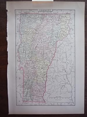
Universal Cyclopaedia and Atlas Map of Vermont Original (1902)
Edité par D. Appleton and Company, 1902
Vendeur : Imperial Books and Collectibles, Wauwatosa, WI, Etats-Unis
Evaluation du vendeur :
No Binding. Etat : Fine. This rare original hand colored map of Vermont is from Volume XII of the 1902 edition of the acclaimed Universal Cyclopaedia and Atlas by D. Appleton and Company. Counties are distinguished by color. Cities, towns, roads and rail lines are clearly depicted. Plate size: - 9" x 5 1/2" (23 x 14 cm). Margins: - Min 1/2in (1.2cm). Condition: Fine All items carefully packed to avoid damage from moisture and rough handling.
-
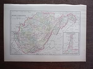
Universal Cyclopaedia and Atlas Map of West Virginia - Original (1902)
Edité par D. Appleton and Company, 1902
Vendeur : Imperial Books and Collectibles, Wauwatosa, WI, Etats-Unis
Evaluation du vendeur :
No Binding. Etat : Fine. This rare original hand colored lithographic map of West Virginia is from Volume XII of the 1902 edition of the acclaimed Universal Cyclopaedia and Atlas Counties are distinguished by color. Cities, towns, roads, rail lines and geographical features are clearly depicted. n. Plate size: - 6 about 9x6" All items carefully packed to avoid damage from moisture and rough handling.
-
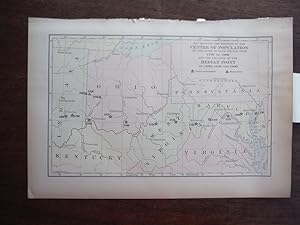
Universal Cyclopaedia and Atlas Map Showing the Position of the Center of Population at the close of each Decade from 1790 to 1900 and the Location of the Median Point in 1880, 1890 and 1900- Original (1902)
Edité par D. Appleton and Company, 1902
Vendeur : Imperial Books and Collectibles, Wauwatosa, WI, Etats-Unis
Evaluation du vendeur :
No Binding. Etat : Fine. This rare hand colored Map Showing the Position of the Center of Population at the close of each Decade from 1790 to 1900 and the Location of the Median Point in 1880, 1890 and 1900 is from Volume XII of the 1902 edition the highly acclaimed Universal Cyclopaedia and Atlas. Plate size: 5.75" x 9.75" (14.6 x 24.8 cm; Margins: Minimum 1/2" (1.3 cm). Condition: Fine All items carefully packed to avoid damage from moisture and rough handling.
-
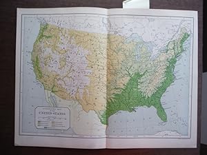
Universal Cyclopaedia and Atlas Hypsometric Map of the United States- Original (1902)
Edité par D. Appleton and Company, 1902
Vendeur : Imperial Books and Collectibles, Wauwatosa, WI, Etats-Unis
Evaluation du vendeur :
No Binding. Etat : Fine. This rare hand colored Hypsometric Map of the United States is from Volume XII of the 1902 edition the highly acclaimed Universal Cyclopaedia and Atlas.It depicts the elevations of the Lower 48 states and territories. Plate size: 9.25" x 13" (23.5 x 33 cm); Margins: Minimum 1/2" (1.3 cm). Condition: Fine with central fold as issued. All items carefully packed to avoid damage from moisture and rough handling.
-

Universal Cyclopaedia and Atlas Political Map of the United States- Original (1902)
Edité par D. Appleton and Company, 1902
Vendeur : Imperial Books and Collectibles, Wauwatosa, WI, Etats-Unis
Evaluation du vendeur :
No Binding. Etat : Fine. This rare hand colored map of the United States is from is from Volume XII of the 1902 edition the highly acclaimed Universal Cyclopaedia and Atlas.It depects the political boundaries of the Lower 48 states and territories. Plate size: 9.25" x 13" (23.5 x 33 cm); Margins: Minimum 1/2" (1.3 cm). Condition: Fine with central fold as issued. All items carefully packed to avoid damage from moisture and rough handling.
-
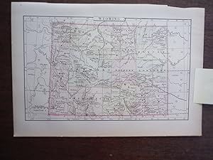
Universal Cyclopaedia and Atlas Map of Wyoming - Original (1902)
Edité par D. Appleton and Company, 1902
Vendeur : Imperial Books and Collectibles, Wauwatosa, WI, Etats-Unis
Evaluation du vendeur :
No Binding. Etat : Fine. This rare original hand colored lithographic map of Wyoming is from Volume XII of the 1902 edition of the acclaimed Universal Cyclopaedia and Atlas Counties are distinguished by color. Cities, towns, roads, rail lines and geographical features are clearly depicted. n. Plate size: - 6 about 6x9" All items carefully packed to avoid damage from moisture and rough handling.
-
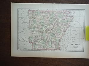
Universal Cyclopaedia and Atlas Map of Arkansas - Original (1902)
Edité par D. Appleton and Company, 1902
Vendeur : Imperial Books and Collectibles, Wauwatosa, WI, Etats-Unis
Evaluation du vendeur :
No Binding. Etat : Fine. This rare original hand colored map of Arkansas is from Volume I of the 1902 edition of the acclaimed Universal Cyclopaedia and Atlas by D. Appleton and Company. Counties are distinguished by color. Cities, towns, roads and rail lines are clearly depicted. Plate size: - 6" x 9 " (15 x 23 cm). Margins: - Min 1/2 in (1.2cm). Condition: Fine All items carefully packed to avoid damage from moisture and rough handling.
-
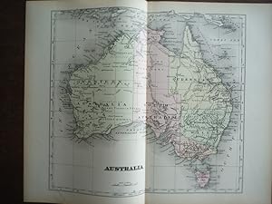
Universal Cyclopaedia and Atlas Map of Australia- Original (1902)
Edité par D. Appleton and Company, 1902
Vendeur : Imperial Books and Collectibles, Wauwatosa, WI, Etats-Unis
Evaluation du vendeur :
No Binding. Etat : Very Good. This rare original hand colored map of Australia from Volume I of the 1902 edition of the acclaimed Universal Cyclopaedia and Atlas by D. Appleton and Company. This extraordinary example of 19th century map making depicts a snapshot of the political environment of Australia at the turn of the 20th century. Plate size: 10" x 12" (25 x 30 cm) ; Margins: - Min 1/2 in (1.2 cm). Condition: Very Good; central fold as issued. Small closed tear along margin not affecting plate. All items carefully packed to avoid damage from moisture and rough handling.
-
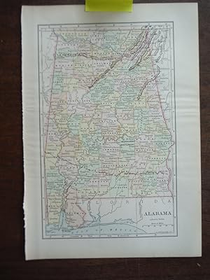
Universal Cyclopaedia and Atlas Map of Alabama - Original (1902)
Edité par D. Appleton and Company, 1902
Vendeur : Imperial Books and Collectibles, Wauwatosa, WI, Etats-Unis
Evaluation du vendeur :
No Binding. Etat : Fine. This rare original hand colored map of Alabama is from Volume I of the 1902 edition of the acclaimed Universal Cyclopaedia and Atlas by D. Appleton and Company. Counties are distinguished by color. Cities, towns, roads and rail lines are clearly depicted. Plate size: - 9" x 6 3/4" (23 x 17 cm). Margins: - Min 1/2in (1.2cm). Condition: Fine All items carefully packed to avoid damage from moisture and rough handling.
-
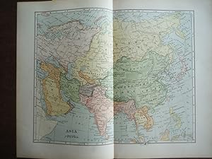
Universal Cyclopaedia and Atlas Map of Asia- Original (1902)
Edité par D. Appleton and Company, 1902
Vendeur : Imperial Books and Collectibles, Wauwatosa, WI, Etats-Unis
Evaluation du vendeur :
No Binding. Etat : Very Good. This rare original hand colored map of Asia from Volume I of the 1902 edition of the acclaimed Universal Cyclopaedia and Atlas by D. Appleton and Company. This extraordinary example of 19th century map making depicts a snapshot of the political environment of Asia at the turn of the 20th century. Plate size: 10" x 12" (25 x 30 cm) ; Margins: - Min 1/2 in (1.2 cm). Condition: Very Good; central fold as issued. Small closed tear along margin not affecting plate. All items carefully packed to avoid damage from moisture and rough handling.
-
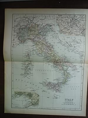
Universal Cyclopaedia and Atlas Map of Italy- Original (1902)
Edité par D. Appleton and Company, 1902
Vendeur : Imperial Books and Collectibles, Wauwatosa, WI, Etats-Unis
Evaluation du vendeur :
No Binding. Etat : Fine. This rare original hand colored map of Italy is from Volume VI of the 1902 edition of the acclaimed Universal Cyclopaedia and Atlas by D. Appleton and Company. Cities, towns, roads, shipping and rail lines are clearly depicted. This map depicts a snapshot of the political landscape of Italy at the dawn of the 20th Century. Plate size: - Size: 12" x 9" (28 x 22 cm); Margins: - Min 1/2in (1.2 cm). Condition: Fine; central fold as issued. All items carefully packed to avoid damage from moisture and rough handling.
-
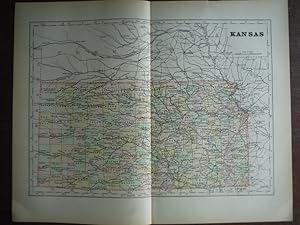
Universal Cyclopaedia and Atlas Map of Kansas - Original (1902)
Edité par D. Appleton and Company, 1902
Vendeur : Imperial Books and Collectibles, Wauwatosa, WI, Etats-Unis
Evaluation du vendeur :
No Binding. Etat : Fine. This rare original hand colored map of Iowa is from Volume VI of the 1902 edition of the acclaimed Universal Cyclopaedia and Atlas by D. Appleton and Company. Counties are distinguished by color. Cities, towns, roads and rail lines are clearly depicted. Plate size: - 8 All items carefully packed to avoid damage from moisture and rough handling.
-
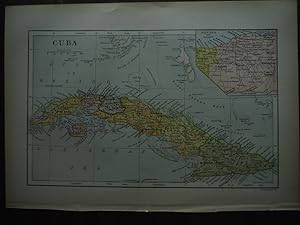
Universal Cyclopaedia and Atlas Map of Cuba - Original (1902)
Edité par D. Appleton and Company, 1902
Vendeur : Imperial Books and Collectibles, Wauwatosa, WI, Etats-Unis
Evaluation du vendeur :
No Binding. Etat : Fine. This rare original hand colored map of Cuba is from Volume III of the 1902 edition of the acclaimed Universal Cyclopaedia and Atlas by D. Appleton and Company. Provinces are distinguished by color. Cities, towns, roads and rail lines are clearly depicted. Inset map of metropolitan Havana Plate size: - 6" x 9 " (15 x 23 cm). Margins: - Min 1/2 in (1.2cm). Condition: Fine All items carefully packed to avoid damage from moisture and rough handling.
-
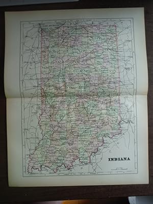
Universal Cyclopaedia and Atlas Map of Indiana - Original (1902)
Edité par D. Appleton and Company, 1902
Vendeur : Imperial Books and Collectibles, Wauwatosa, WI, Etats-Unis
Evaluation du vendeur :
No Binding. Etat : Fine. This rare original hand colored map of Indiana is from Volume VI of the 1902 edition of the acclaimed Universal Cyclopaedia and Atlas by D. Appleton and Company. Counties are distinguished by color. Cities, towns, roads and rail lines are clearly depicted. Plate size: - 11" x 9" (28 x 23 cm). Margins: - Min 1/2in (1.2cm). Condition: Fine; central fold as issued. All items carefully packed to avoid damage from moisture and rough handling.
-
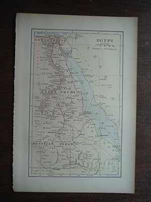
Universal Cyclopaedia and Atlas Map of Egypt - Original (1902)
Edité par D. Appleton and Company, 1902
Vendeur : Imperial Books and Collectibles, Wauwatosa, WI, Etats-Unis
Evaluation du vendeur :
No Binding. Etat : Fine. This rare original hand colored map of Egypt is from Volume III of the 1902 edition of the acclaimed Universal Cyclopaedia and Atlas by D. Appleton and Company. Cities, towns, roads, shipping and rail lines are clearly depicted. : Plate size: 9" x 6" (23 x 15 ). Margins: - Min 1/2 in (1.2cm). Condition: Fine All items carefully packed to avoid damage from moisture and rough handling.
-
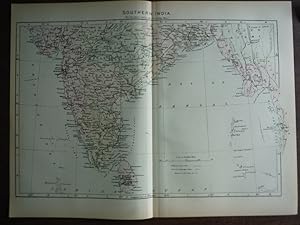
Universal Cyclopaedia and Atlas Map of Southern India - Original (1902)
Edité par D. Appleton and Company, 1902
Vendeur : Imperial Books and Collectibles, Wauwatosa, WI, Etats-Unis
Evaluation du vendeur :
No Binding. Etat : Fine. This rare original hand colored map of Northern India is from Volume VI .of the 1902 edition of the acclaimed Universal Cyclopaedia and Atlas by D. Appleton and Company. Cities, towns, roads, shipping and rail lines are clearly depicted. : This map depicts a snapshot of the political landscape of Southern India at the dawn of the 20th Century and remains relevant 110 years later. Plate size: - 9" x 13" (23 x 33 cm) Margins: - Min 1/2in (1.2 cm). Condition: Fine; Central fold as issued All items carefully packed to avoid damage from moisture and rough handling.
-
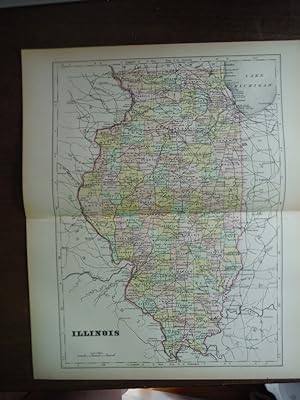
Universal Cyclopaedia and Atlas Map of Illinois Original (1902)
Edité par D. Appleton and Company, 1902
Vendeur : Imperial Books and Collectibles, Wauwatosa, WI, Etats-Unis
Evaluation du vendeur :
No Binding. Etat : Fine. This rare original hand colored map of Illinois is from Volume VI of the 1902 edition of the acclaimed Universal Cyclopaedia and Atlas by D. Appleton and Company. Counties are distinguished by color. Cities, towns, roads and rail lines are clearly depicted. Plate size: - 11" x 9" (28 x 23 cm). Margins: - Min 1/2in (1.2cm). Condition: Fine; central fold as issued. All items carefully packed to avoid damage from moisture and rough handling.
-
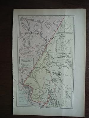
Universal Cyclopaedia and Atlas Map of the Klondike Gold Region Canada - Original (1902)
Edité par D. Appleton and Company, 1902
Vendeur : Imperial Books and Collectibles, Wauwatosa, WI, Etats-Unis
Evaluation du vendeur :
No Binding. Etat : Fine. This rare original hand colored map of the Klondike Gold Region Canada is from Volume VI of the 1902 edition of the acclaimed Universal Cyclopaedia and Atlas by D. Appleton and Company. Cities, towns, roads and rail lines are clearly depicted. Includes insert of the Klondike River and Vicinity. Plate size: - 9 All items carefully packed to avoid damage from moisture and rough handling.
-
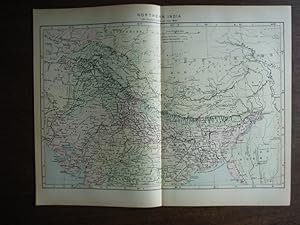
Universal Cyclopaedia and Atlas Map of Northern India - Original (1902)
Edité par D. Appleton and Company, 1902
Vendeur : Imperial Books and Collectibles, Wauwatosa, WI, Etats-Unis
Evaluation du vendeur :
No Binding. Etat : Fine. This rare original hand colored map of Northern India is from Volume VI .of the 1902 edition of the acclaimed Universal Cyclopaedia and Atlas by D. Appleton and Company. Cities, towns, roads, shipping and rail lines are clearly depicted. : This map depicts a snapshot of the political landscape of Northern India at the dawn of the 20th Century and remains relevant 110 years later. Plate size: - 9" x 13" (23 x 33 cm) Margins: - Min 1/2in (1.2 cm). Condition: Fine; Central fold as issued All items carefully packed to avoid damage from moisture and rough handling.
-
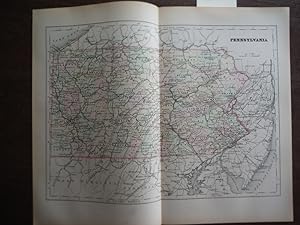
Universal Cyclopaedia and Atlas Map of Pennsylvania - Original (1902)
Edité par D. Appleton and Company, 1902
Vendeur : Imperial Books and Collectibles, Wauwatosa, WI, Etats-Unis
Evaluation du vendeur :
No Binding. Etat : Fine. This rare original hand colored copper plate engraved map of Pennsylvania is from Volume IX of the 1902 edition of the acclaimed Universal Cyclopaedia and Atlas by D. Appleton and Company. Counties are distinguished by color. Cities, towns, roads and rail lines are clearly depicted. Plate size: - 8 All items carefully packed to avoid damage from moisture and rough handling.
-
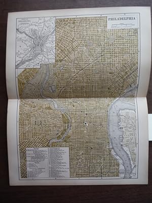
Universal Cyclopaedia and Atlas Map of Philadelphia (Pennsylvania) - Original (1902)
Edité par D. Appleton and Company, 1902
Vendeur : Imperial Books and Collectibles, Wauwatosa, WI, Etats-Unis
Evaluation du vendeur :
No Binding. Etat : Fine. This rare colored lithographic map of the City of Philadelphia is from Volume IX of the 1902 edition of the acclaimed Universal Cyclopaedia and Atlas. Streets, public buildings, colleges, hospitals, rail depots, rail lines, hotels, theatres and churches are clearly identified. Plate size: Plate size: - 12" x 9" ( 30 x 23 cm); Margins: - Min 0.5 in (22.8 mm). Condition: Fine; Central fold, as issued. . All items carefully packed to avoid damage from moisture and rough handling.
-
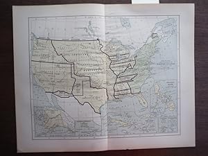
Universal Cyclopaedia and Atlas Map Showing Land Acquired by the United States from 1783 to 1899- Original (1902)
Edité par D. Appleton and Company, 1902
Vendeur : Imperial Books and Collectibles, Wauwatosa, WI, Etats-Unis
Evaluation du vendeur :
No Binding. Etat : Fine. This rare hand colored map Showing Land Acquired by the United States from 1783 to 1899 from is from Volume XII of the 1902 edition of the highly acclaimed Universal Cyclopaedia and Atlas. Included are inserts of Alaska; the Hawaiian or Sandwich Islands and Wake Island; part of the West Indies, the Philippine Islands; Guam Islands and Tutula Island. Plate size: 9.25" x 13" (23.5 x 33 cm); Margins: Minimum 1/2" (1.3 cm). Condition: Fine with central fold as issued. All items carefully packed to avoid damage from moisture and rough handling.