Montant total (1 article articles) :
Destination de la commande :

vandermaelen philippe marie guillaume (410 résultats)
Passer aux résultats principaux de la recherche
Type d'article
- Tous les types d'articles
- Livres (5)
- Magazines & Périodiques
- Bandes dessinées
- Partitions de musique
- Art, Affiches et Gravures
- Photographies
- Cartes (405)
-
Manuscrits &
Papiers anciens
Etat
- Tous
- Neuf
- Ancien ou d'occasion
Reliure
- Toutes
- Couverture rigide
- Couverture souple (1)
Particularités
- Edition originale
- Signé
- Jaquette
- Avec images (407)
- Sans impression ŕ la demande
Pays
Evaluation du vendeur
-
![Image du vendeur pour Asie - Suite de la Note sur les Indes Orientales [Pour le commencement de la Note Voyez la Carle] - No. 103 (bis) mis en vente par Antiqua Print Gallery](https://pictures.abebooks.com/inventory/md/md31102185995.jpg)
Asie - Suite de la Note sur les Indes Orientales [Pour le commencement de la Note Voyez la Carle] - No. 103 (bis)
Date d'édition : 1827
Carte
Etat : Good. Asie. Suite de la Note Indes Orientales #103 bis. India. VANDERMAELEN 1827 map. Antique folio-sized lithographic atlas map, hand coloured in outline, on conical projection. This map was published within the first atlas ever to be printed using lithography, and also the first to be printed on a uniform scale; Philippe Marie Guillaume Vandermaelen. Lithography by Henri Ode (1827). 51.5 x 50.5cm, 20.25 x 19.75 inches. Condition: Good. Minor offsetting -text and/or images from the facing page have left an impression on the print. There is nothing printed on the reverse side, which is plain. Includes tables of population, religion and ethnicity.
-
![Image du vendeur pour Afrique - Désert de Lybie [Suite de la Note sur le Barca; Note sur l'Egypte] - No. 17 mis en vente par Antiqua Print Gallery](https://pictures.abebooks.com/inventory/md/md31102185085.jpg)
Afrique - Désert de Lybie [Suite de la Note sur le Barca; Note sur l'Egypte] - No. 17
Date d'édition : 1827
Carte
Etat : Good. Afrique. Désert de Lybie #17 Sahara Libya Egypt Chad Sudan VANDERMAELEN 1827 map. Antique folio-sized lithographic atlas map, hand coloured in outline, on conical projection. This map was published within the first atlas ever to be printed using lithography, and also the first to be printed on a uniform scale; Philippe Marie Guillaume Vandermaelen. Lithography by Henri Ode (1827). 51.0 x 57.0cm, 20 x 22.5 inches. Condition: Good. There is nothing printed on the reverse side, which is plain. The Sahara Desert in south-east Libya, south-west Egypt, north-west Sudan and north-east Chad.
-
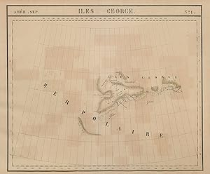
Etat : Good. Amér. Sep. Iles George #1. Melville Island Canadian Arctic VANDERMAELEN 1827 map. Antique folio-sized lithographic atlas map, hand coloured in outline, on conical projection. This map was published within the first atlas ever to be printed using lithography, and also the first to be printed on a uniform scale; Philippe Marie Guillaume Vandermaelen. Lithography by Henri Ode (1827). 51.5 x 62.0cm, 20.25 x 24.5 inches. Condition: Good. Light spotting; Minor offsetting -text and/or images from the facing page have left an impression on the print. There is nothing printed on the reverse side, which is plain. The map covers Melville Island and parts of the adjacent Bathurst and Banks Islands in the Canadian Arctic Archipelago, Nunavut.
-
![Image du vendeur pour Afrique - Partie du Désert de Sahara [Note sur les Arabes Bedouins ou Monslemines] - No. 7 mis en vente par Antiqua Print Gallery](https://pictures.abebooks.com/inventory/md/md31102174899.jpg)
Afrique - Partie du Désert de Sahara [Note sur les Arabes Bedouins ou Monslemines] - No. 7
Date d'édition : 1827
Carte
Etat : Good. Afrique Partie Désert de Sahara 7 Algeria Mauritania Mali VANDERMAELEN 1827 map. Antique folio-sized lithographic atlas map, hand coloured in outline, on conical projection. This map was published within the first atlas ever to be printed using lithography, and also the first to be printed on a uniform scale; Philippe Marie Guillaume Vandermaelen. Lithography by Henri Ode (1827). 51.0 x 56.5cm, 20 x 22.25 inches. Condition: Good. There is nothing printed on the reverse side, which is plain. Western Algeria, northern Mauritania & Mali.
-
![Image du vendeur pour Amérique Méridionale - Partie de la Guyane Anglaise [Note sure les petites Antilles] - No. 4 (bis) mis en vente par Antiqua Print Gallery](https://pictures.abebooks.com/inventory/md/md31102177745.jpg)
Amérique Méridionale - Partie de la Guyane Anglaise [Note sure les petites Antilles] - No. 4 (bis)
Date d'édition : 1827
Carte
Etat : Good. Amér. Mér. Guyane Anglaise #4 bis. Guyana Suriname. VANDERMAELEN 1827 old map. Antique folio-sized lithographic atlas map, hand coloured in outline, on conical projection. This map was published within the first atlas ever to be printed using lithography, and also the first to be printed on a uniform scale; Philippe Marie Guillaume Vandermaelen. Lithography by Henri Ode (1827). 50.0 x 59.5cm, 19.75 x 23.25 inches. Condition: Good. There is nothing printed on the reverse side, which is plain. Most of the sheet is descriptive text about the Windward and Leeward Islands. The estuary of the Courantyne/Corentyne/Corantijn River between Guyana and Suriname is shown in the bottom left hand corner. Longitude values are erroneously reversed.
-
![Image du vendeur pour Afrique - Tawat [Suite de la note sur les Tibbous et les Touariks] - No. 8 mis en vente par Antiqua Print Gallery](https://pictures.abebooks.com/inventory/md/md31102178668.jpg)
Afrique - Tawat [Suite de la note sur les Tibbous et les Touariks] - No. 8
Date d'édition : 1827
Carte
Etat : Good. Afrique. Tawat #8. Tuat Oases, central Algeria. VANDERMAELEN 1827 old map. Antique folio-sized lithographic atlas map, hand coloured in outline, on conical projection. This map was published within the first atlas ever to be printed using lithography, and also the first to be printed on a uniform scale; Philippe Marie Guillaume Vandermaelen. Lithography by Henri Ode (1827). 51.0 x 56.0cm, 20.25 x 22 inches. Condition: Good. There is nothing printed on the reverse side, which is plain. Central Algeria showing Saharan caravan routes. Region of the Tuat Oases.
-
![Image du vendeur pour Afrique - Pays au sud du Lac Tchad [Note sur le Arabes Bédouins ou Monslemines] - No. 30 mis en vente par Antiqua Print Gallery](https://pictures.abebooks.com/inventory/md/md31102178670.jpg)
Afrique - Pays au sud du Lac Tchad [Note sur le Arabes Bédouins ou Monslemines] - No. 30
Date d'édition : 1827
Carte
Etat : Good. Afrique Pays sud du Lac Tchad 30 Central African Republic VANDERMAELEN 1827 map. Antique folio-sized lithographic atlas map, hand coloured in outline, on conical projection. This map was published within the first atlas ever to be printed using lithography, and also the first to be printed on a uniform scale; Philippe Marie Guillaume Vandermaelen. Lithography by Henri Ode (1827). 50.5 x 60.5cm, 20 x 23.75 inches. Condition: Good. Light spotting. There is nothing printed on the reverse side, which is plain. Southern Chad and the northern part of the Central African Republic.
-
![Image du vendeur pour Afrique - Donga [Note sur l'Abyssinie] - No. 31 mis en vente par Antiqua Print Gallery](https://pictures.abebooks.com/inventory/md/md31102178671.jpg)
Etat : Good. Afrique. Donga #31. South / Southern Sudan. White Nile. VANDERMAELEN 1827 map. Antique folio-sized lithographic atlas map, hand coloured in outline, on conical projection. This map was published within the first atlas ever to be printed using lithography, and also the first to be printed on a uniform scale; Philippe Marie Guillaume Vandermaelen. Lithography by Henri Ode (1827). 51.0 x 60.0cm, 20 x 23.5 inches. Condition: Good. Light spotting. There is nothing printed on the reverse side, which is plain. Southern Sudan and South Sudan, showing the supposed course of the White Nile, and the Mountains of the Moon.
-
![Image du vendeur pour Afrique - Partie du Désert de Sahara [Note sur les Arabes Bédouins ou Monslemines] - No. 13 mis en vente par Antiqua Print Gallery](https://pictures.abebooks.com/inventory/md/md31102179220.jpg)
Afrique - Partie du Désert de Sahara [Note sur les Arabes Bédouins ou Monslemines] - No. 13
Date d'édition : 1827
Carte
Etat : Good. Afrique. Partie du Désert de Sahara #13. Mauritania Mali. VANDERMAELEN 1827 map. Antique folio-sized lithographic atlas map, hand coloured in outline, on conical projection. This map was published within the first atlas ever to be printed using lithography, and also the first to be printed on a uniform scale; Philippe Marie Guillaume Vandermaelen. Lithography by Henri Ode (1827). 51.0 x 57.5cm, 20 x 22.5 inches. Condition: Good. There is nothing printed on the reverse side, which is plain. The western Sahara desert in eastern Mauritania & western Mali.
-
![Image du vendeur pour Afrique - Partie du Sahara [Note Sur les Tibbous et les Touariks] - No. 16 mis en vente par Antiqua Print Gallery](https://pictures.abebooks.com/inventory/md/md31102179221.jpg)
Afrique - Partie du Sahara [Note Sur les Tibbous et les Touariks] - No. 16
Date d'édition : 1827
Carte
Etat : Good. Afrique. Partie du Sahara #16. Niger & Chad Libya. VANDERMAELEN 1827 old map. Antique folio-sized lithographic atlas map, hand coloured in outline, on conical projection. This map was published within the first atlas ever to be printed using lithography, and also the first to be printed on a uniform scale; Philippe Marie Guillaume Vandermaelen. Lithography by Henri Ode (1827). 51.5 x 58.0cm, 20.25 x 22.75 inches. Condition: Good. Blemish in margin; Minor offsetting -text and/or images from the facing page have left an impression on the print. There is nothing printed on the reverse side, which is plain. The Sahara Desert in northern Niger & Chad, and southern Libya.
-
![Image du vendeur pour Afrique - Matamba [Note sur le Congo] - No. 42 mis en vente par Antiqua Print Gallery](https://pictures.abebooks.com/inventory/md/md31102179224.jpg)
Etat : Good. Afrique. Matamba #42. Eastern Angola. Upper Cuanza River. VANDERMAELEN 1827 map. Antique folio-sized lithographic atlas map, hand coloured in outline, on conical projection. This map was published within the first atlas ever to be printed using lithography, and also the first to be printed on a uniform scale; Philippe Marie Guillaume Vandermaelen. Lithography by Henri Ode (1827). 51.0 x 60.0cm, 20 x 23.5 inches. Condition: Good. There is nothing printed on the reverse side, which is plain. Eastern Angola, mostly uncharted, but showing the upper Cuanza River.
-

Etat : Good. Afrique. Territoire des Cazembes #45 SE Angola West Zambia VANDERMAELEN 1827 map. Antique folio-sized lithographic atlas map, hand coloured in outline, on conical projection. This map was published within the first atlas ever to be printed using lithography, and also the first to be printed on a uniform scale; Philippe Marie Guillaume Vandermaelen. Lithography by Henri Ode (1827). 51.0 x 58.5cm, 20 x 23 inches. Condition: Good. Minor offsetting -text and/or images from the facing page have left an impression on the print. There is nothing printed on the reverse side, which is plain. South eastern Angola and western Zambia, mostly uncharted reflecting the limited state of European knowledge of the interior of the African continent at the time of publication, but showing a number of tributaries of (presumbly) the Zambezi river.
-
![Image du vendeur pour Afrique - Partie du Désert de Sahara [Note sur les Arabes Bédouins ou Monslemines] - No. 14 mis en vente par Antiqua Print Gallery](https://pictures.abebooks.com/inventory/md/md31102182165.jpg)
Afrique - Partie du Désert de Sahara [Note sur les Arabes Bédouins ou Monslemines] - No. 14
Date d'édition : 1827
Carte
Etat : Good. Afrique. Partie du Désert de Sahara #14. Algeria Mali. VANDERMAELEN 1827 map. Antique folio-sized lithographic atlas map, hand coloured in outline, on conical projection. This map was published within the first atlas ever to be printed using lithography, and also the first to be printed on a uniform scale; Philippe Marie Guillaume Vandermaelen. Lithography by Henri Ode (1827). 51.0 x 57.5cm, 20 x 22.5 inches. Condition: Good. There is nothing printed on the reverse side, which is plain. The Sahara Desert in Southern Algeria & northern Mali.
-
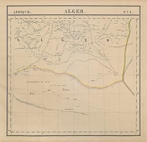
Etat : Good. Afrique. Alger #2. Algeria interior. VANDERMAELEN 1827 old antique map chart. Antique folio-sized lithographic atlas map, hand coloured in outline, on conical projection. This map was published within the first atlas ever to be printed using lithography, and also the first to be printed on a uniform scale; Philippe Marie Guillaume Vandermaelen. Lithography by Henri Ode (1827). 51.5 x 53.5cm, 20.25 x 21 inches. Condition: Good. There is nothing printed on the reverse side, which is plain. Northern Algeria. Bescara (Biskra) is marked centrally between 34 and 35 degrees of Latitude.
-
![Image du vendeur pour Afrique - Partie du Congo [Note générale sur l'Afrique] - No. 39 mis en vente par Antiqua Print Gallery](https://pictures.abebooks.com/inventory/md/md31102184126.jpg)
Etat : Good. Afrique. Partie du Congo. Note générale sur l'Afrique #39. VANDERMAELEN 1827 map. Antique folio-sized lithographic atlas map, hand coloured in outline, on conical projection. This map was published within the first atlas ever to be printed using lithography, and also the first to be printed on a uniform scale; Philippe Marie Guillaume Vandermaelen. Lithography by Henri Ode (1827). 51.0 x 60.5cm, 20 x 23.75 inches. Condition: Good. There is nothing printed on the reverse side, which is plain. The substantially unexplored interior of western Congo, showing tributaries of the Congo River and a description of Africa.
-
![Image du vendeur pour Afrique - Touariks [Note Sur les Tibbous et les Touariks] - No. 15 mis en vente par Antiqua Print Gallery](https://pictures.abebooks.com/inventory/md/md31102185997.jpg)
Etat : Good. Afrique. Touariks #15. Sahara in SE Niger & Northern Niger VANDERMAELEN 1827 map. Antique folio-sized lithographic atlas map, hand coloured in outline, on conical projection. This map was published within the first atlas ever to be printed using lithography, and also the first to be printed on a uniform scale; Philippe Marie Guillaume Vandermaelen. Lithography by Henri Ode (1827). 51.5 x 58.0cm, 20.25 x 22.75 inches. Condition: Good. There is nothing printed on the reverse side, which is plain. The Sahara Desert in South-east Algeria & northern Niger.
-
![Image du vendeur pour Océanique - Partie des Iles Mariannes [Note sur les îles Sandwich] - No. 2 mis en vente par Antiqua Print Gallery](https://pictures.abebooks.com/inventory/md/md31102186916.jpg)
Océanique - Partie des Iles Mariannes [Note sur les îles Sandwich] - No. 2
Date d'édition : 1827
Carte
Etat : Good. Océanique. Partie Iles Mariannes #2 North Mariana Islands VANDERMAELEN 1827 map. Antique folio-sized lithographic atlas map, hand coloured in outline, on conical projection. This map was published within the first atlas ever to be printed using lithography, and also the first to be printed on a uniform scale; Philippe Marie Guillaume Vandermaelen. Lithography by Henri Ode (1827). 51.5 x 57.0cm, 20.25 x 22.5 inches. Condition: Good. There is nothing printed on the reverse side, which is plain. The northern Mariana Islands, from Alamagan northwards.
-
![Image du vendeur pour Océanique - Partie des Iles Mariannes [Note sur les îles Sandwich] - No. 2 mis en vente par Antiqua Print Gallery](https://pictures.abebooks.com/inventory/md/md31759140902.jpg)
Océanique - Partie des Iles Mariannes [Note sur les îles Sandwich] - No. 2
Date d'édition : 1827
Carte
Etat : Good. Océanique. Partie Iles Mariannes #2 North Mariana Islands VANDERMAELEN 1827 map. Antique folio-sized lithographic atlas map, hand coloured in outline, on conical projection. This map was published within the first atlas ever to be printed using lithography, and also the first to be printed on a uniform scale; Philippe Marie Guillaume Vandermaelen. Lithography by Henri Ode (1827). 51.5 x 57.0cm, 20.25 x 22.5 inches. Condition: Good. There is nothing printed on the reverse side, which is plain. The northern Mariana Islands, from Alamagan northwards.
-
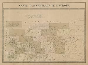
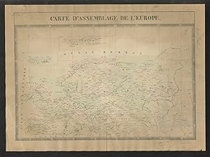
Etat : Good. Carte d'Assemblage de l'Europe. Index map. VANDERMAELEN 1827 old antique. Antique folio-sized lithographic atlas map, hand coloured in outline, on conical projection. This map was published within the first atlas ever to be printed using lithography, and also the first to be printed on a uniform scale; Philippe Marie Guillaume Vandermaelen. Lithography by Henri Ode (1827). 50.0 x 68.0cm, 19.75 x 26.75 inches. Condition: Good. Light spotting. There is nothing printed on the reverse side, which is plain.
-
Etat : Good. "Carte d'Assemblage de l'Europe. VANDERMAELEN 1827 old antique map plan chart. Antique folio-sized lithographic atlas map, hand coloured in outline, on conical projection. This map was published within the first atlas ever to be printed using lithography, and also the first to be printed on a uniform scale; Philippe Marie Guillaume Vandermaelen. Lithography by Henri Ode (1827). 71.0 x 52.0cm, 27.75 x 20.25 inches; this is a folding map. Condition: Good. There is nothing printed on the reverse side, which is plain.
-
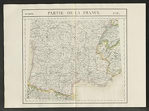
Etat : Good. "Partie de la France" #19 Southern France & Savoie. VANDERMAELEN 1827 old map. Antique folio-sized lithographic atlas map, hand coloured in outline, on conical projection. This map was published within the first atlas ever to be printed using lithography, and also the first to be printed on a uniform scale; Philippe Marie Guillaume Vandermaelen. Lithography by Henri Ode (1827). 71.0 x 52.0cm, 27.75 x 20.25 inches; this is a folding map. Condition: Good. There is nothing printed on the reverse side, which is plain. Central and southern France, western Switzerland, and part of the Kingdom of Sardinia (now north-western Italy, Savoie and Alpes-Maritimes).
-
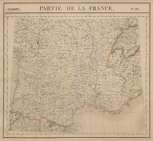
Etat : Good. Europe. France #19 Southern France & Savoie. VANDERMAELEN 1827 old antique map. Antique folio-sized lithographic atlas map, hand coloured in outline, on conical projection. This map was published within the first atlas ever to be printed using lithography, and also the first to be printed on a uniform scale; Philippe Marie Guillaume Vandermaelen. Lithography by Henri Ode (1827). 50.5 x 55.0cm, 19.75 x 21.5 inches. Condition: Good. There is nothing printed on the reverse side, which is plain. Central and southern France, western Switzerland, and part of the Kingdom of Sardinia (now north-western Italy, Savoie and Alpes-Maritimes).
-
![Image du vendeur pour Amér. Sep. - Embouchure du Fleuve Mackensie [Lettre du Capitaine Franklin] - No. 6 mis en vente par Antiqua Print Gallery](https://pictures.abebooks.com/inventory/md/md31102186906.jpg)
Amér. Sep. - Embouchure du Fleuve Mackensie [Lettre du Capitaine Franklin] - No. 6
Date d'édition : 1827
Carte
Etat : Good. Amér. Sep. Embouchure du Mackensie #6. Mackenzie estuary. VANDERMAELEN 1827 map. Antique folio-sized lithographic atlas map, hand coloured in outline, on conical projection. This map was published within the first atlas ever to be printed using lithography, and also the first to be printed on a uniform scale; Philippe Marie Guillaume Vandermaelen. Lithography by Henri Ode (1827). 51.5 x 61.0cm, 20.25 x 24 inches. Condition: Good. There is nothing printed on the reverse side, which is plain. The map shows the mouth of the Mackenzie River into the Arctic Ocean. Inset is a transcription of a letter from Captain John Franklin, written on his second expedition to the Canadian Arctic in 1825.
-
Etat : Good. Russie d'Asie #2 Russia. Kara Sea. Taymyr peninsula VANDERMAELEN 1827 old map. Antique folio-sized lithographic atlas map, hand coloured in outline, on conical projection. This map was published within the first atlas ever to be printed using lithography, and also the first to be printed on a uniform scale; Philippe Marie Guillaume Vandermaelen. Lithography by Henri Ode (1827). 51.5 x 61.0cm, 20.25 x 24 inches. Condition: Good. There is nothing printed on the reverse side, which is plain. The northern tip of Novaya Zemlya, the Kara Sea, and the western part of the Taymyr Peninsula. Shows explorers' routes.
-
Etat : Good. Russie d'Asie #10 Siberia Russia. Northern Chukotka Sakha. VANDERMAELEN 1827 map. Antique folio-sized lithographic atlas map, hand coloured in outline, on conical projection. This map was published within the first atlas ever to be printed using lithography, and also the first to be printed on a uniform scale; Philippe Marie Guillaume Vandermaelen. Lithography by Henri Ode (1827). 51.0 x 60.5cm, 20 x 23.75 inches. Condition: Good. There is nothing printed on the reverse side, which is plain. Part of Northern Siberia. The north west coast of Chukotka and the north east coast of Sakha, including the Kolyma River delta and Chaunskaya Bay, and the adjacent East Siberia Sea. Shows explorers' routes.
-
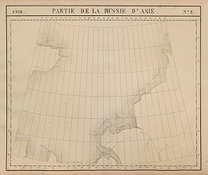
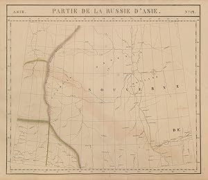
Etat : Good. Russie d'Asie #14 Central Siberia Russia. Yenisei basin. VANDERMAELEN 1827 map. Antique folio-sized lithographic atlas map, hand coloured in outline, on conical projection. This map was published within the first atlas ever to be printed using lithography, and also the first to be printed on a uniform scale; Philippe Marie Guillaume Vandermaelen. Lithography by Henri Ode (1827). 51.0 x 59.5cm, 20.25 x 23.25 inches. Condition: Good. Minor offsetting -text and/or images from the facing page have left an impression on the print. There is nothing printed on the reverse side, which is plain. Part of Central Siberia. Yenisei River basin including Nizhnyaya Tunguska and Podkamennaya Tunguska tributaries, Krasnoyarsk Krai.
-

Etat : Good. Russie d'Asie #18 Russia. NE Magadan. NW Kamchatka Krai. VANDERMAELEN 1827 map. Antique folio-sized lithographic atlas map, hand coloured in outline, on conical projection. This map was published within the first atlas ever to be printed using lithography, and also the first to be printed on a uniform scale; Philippe Marie Guillaume Vandermaelen. Lithography by Henri Ode (1827). 51.5 x 59.0cm, 20.25 x 23.25 inches. Condition: Good. Minor offsetting -text and/or images from the facing page have left an impression on the print. There is nothing printed on the reverse side, which is plain. The north east part of Magadan Oblast, and the north west part of Kamchatka Krai.
-
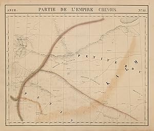
Etat : Good. Asie. Empire Chinois #55 Tajikistan Uzbekistan Kyrgyzstan. VANDERMAELEN 1827 map. Antique folio-sized lithographic atlas map, hand coloured in outline, on conical projection. This map was published within the first atlas ever to be printed using lithography, and also the first to be printed on a uniform scale; Philippe Marie Guillaume Vandermaelen. Lithography by Henri Ode (1827). 51.0 x 60.0cm, 20 x 23.5 inches. Condition: Good. Offsetting - text and/or images from the facing page have left an impression on the print. There is nothing printed on the reverse side, which is plain. Part of central Asia: Western Xinjiang, eastern Tajikistan & Uzbekistan, southern Kyrgyzstan, north-eastern Afghanistan.
-

Etat : Good. Russie d'Asie #11 Russia. Chukchi Peninsula & sea. VANDERMAELEN 1827 old map. Antique folio-sized lithographic atlas map, hand coloured in outline, on conical projection. This map was published within the first atlas ever to be printed using lithography, and also the first to be printed on a uniform scale; Philippe Marie Guillaume Vandermaelen. Lithography by Henri Ode (1827). 51.5 x 61.0cm, 20.25 x 24 inches. Condition: Good. There is nothing printed on the reverse side, which is plain. The north coast of the Chukchi Peninsula, and the Chukchi Sea. Shows explorers' routes.
-
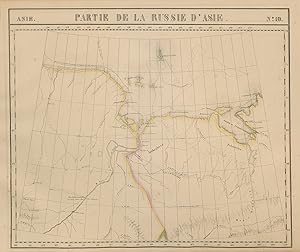
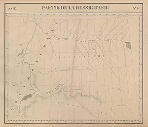
Etat : Good. Russie d'Asie #12 West Siberia. Russia. Khanty-Mansi Komi. VANDERMAELEN 1827 map. Antique folio-sized lithographic atlas map, hand coloured in outline, on conical projection. This map was published within the first atlas ever to be printed using lithography, and also the first to be printed on a uniform scale; Philippe Marie Guillaume Vandermaelen. Lithography by Henri Ode (1827). 51.5 x 59.5cm, 20.25 x 23.5 inches. Condition: Good. Minor offsetting -text and/or images from the facing page have left an impression on the print; Light crease. There is nothing printed on the reverse side, which is plain. Part of Western Siberia. Western Khanty-Mansi Autonomous Okrug & eastern Komi Republic. Ural mountains & Ob River basin.