
Montant total (1 article articles) :
Destination de la commande :

visscher nicolas jansz (6 résultats)
Passer aux résultats principaux de la recherche
Type d'article
- Tous les types d'articles
- Livres
- Magazines & Périodiques
- Bandes dessinées
- Partitions de musique
- Art, Affiches et Gravures
- Photographies
- Cartes (6)
-
Manuscrits &
Papiers anciens
Etat
- Tous
- Neuf
- Ancien ou d'occasion
Reliure
- Toutes
- Couverture rigide
- Couverture souple
Particularités
- Edition originale
- Signé
- Jaquette
- Avec images
- Sans impression ŕ la demande
Pays
Evaluation du vendeur
-
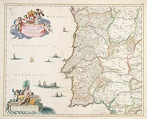
Portugalliae et Algarbiae Regna.
Date d'édition : 1680
Vendeur : Altea Antique Maps, London, Royaume-Uni
Membre d'association : ABA ILAB PBFA
Evaluation du vendeur :

Carte
Amsterdam, c.1680. Original colour. 505 x 530mm. Repairs to centre fold. A fine map of Portugal with decorative cartouches for the title and scale, both in full colour.
-
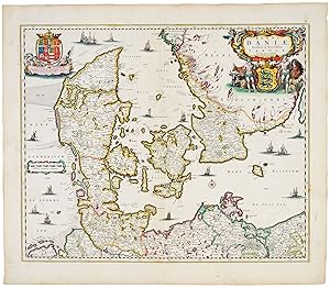
Regni Daniae Novissima et Accuratissima Tabula.
Date d'édition : 1670
Vendeur : Altea Antique Maps, London, Royaume-Uni
Membre d'association : ABA ILAB PBFA
Evaluation du vendeur :
Carte
Amsterdam, c.1670. Fine original colour. 460 x 555mm. A very fine example of this map of Denmark, decorated with cartouches for the title, dedicated to Christian V and scale.
-
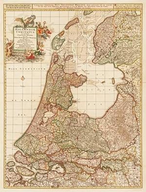
Hollandić Comitatus in Ejusdem Subjacentes Ditiones; una cum Toto Ultrajectino Dominio.
Date d'édition : 1690
Vendeur : Altea Antique Maps, London, Royaume-Uni
Membre d'association : ABA ILAB PBFA
Evaluation du vendeur :
Carte
No Binding. Etat : Very Good. Amsterdam, c.1690. Original colour. Two sheets conjoined, total 760 x 570mm. Repaired tear at fold. A detailed map of Holland, a province in the west of the Netherlands. The elaborate title cartouche celebrates the region's maritime accomplishments.
-
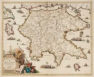
Peloponnesus hodie Morea.
Date d'édition : 1698
Vendeur : Altea Antique Maps, London, Royaume-Uni
Membre d'association : ABA ILAB PBFA
Evaluation du vendeur :
Carte
Amsterdam, 1698. Original colour. 455 x 560mm. A very fine example. A decorative and detailed map of the Morea or Peloponnese, published at when it was in the tenuous possession of Venice. Thus the title cartouche features the campanile of St Mark's and the Venetian lion surrounded by vanquished Turks. ZACHARAKIS: 2350.
-
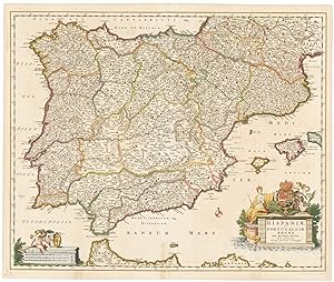
Hispaniae et Portugalliae Regna.
Date d'édition : 1680
Vendeur : Altea Antique Maps, London, Royaume-Uni
Membre d'association : ABA ILAB PBFA
Evaluation du vendeur :
Carte
Amsterdam, c.1680. Original colour heightened in gold . 470 x 570mm. A very fine map of Spain and Portugal with decorative cartouches for the title and scale, both in full colour.
-
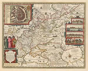
Tabula Russić ex mandato Foedor Borissowits delineata. 1651.
Date d'édition : 1651
Vendeur : Altea Antique Maps, London, Royaume-Uni
Membre d'association : ABA ILAB PBFA
Evaluation du vendeur :
Carte
Amsterdam: 1651. Coloured. 430 x 540mm. Highly decorative map of Russia, based on Hessel Gerritz's map of 1613, with a large inset plan of Moscow to the top left, and to the right five prospects of Archangel, Narva and the Kremlin, and depiction of Russian steam baths. The map covers the European part of the Russian Empire extending from Poland to the steppes of Tartary, and from the Mourmanskoy More (Barents Sea) to the Black and Caspian Seas. The map is richly decorated with a large title cartouche surmounted by Russian gentlemen, sailing ships, and a compass rose.