
Montant total (1 article articles) :
Destination de la commande :

w blaeu joan blaeu (7 résultats)
Passer aux résultats principaux de la recherche
Type d'article
- Tous les types d'articles
- Livres (7)
- Magazines & Périodiques
- Bandes dessinées
- Partitions de musique
- Art, Affiches et Gravures
- Photographies
- Cartes
-
Manuscrits &
Papiers anciens
Etat
- Tous
- Neuf
- Ancien ou d'occasion
Reliure
- Toutes
- Couverture rigide (6)
- Couverture souple
Particularités
- Edition originale (2)
- Signé
- Jaquette (2)
- Avec images (1)
- Sans impression ŕ la demande
Pays
Evaluation du vendeur
-
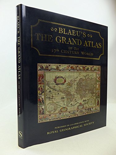
Blaeus the Grand Atlas of the 17th Century World
Edité par Studio Edns., 1997
ISBN 10 : 1858915880ISBN 13 : 9781858915883
Livre
Hardcover. Etat : Used; Good. **SHIPPED FROM UK** We believe you will be completely satisfied with our quick and reliable service. All orders are dispatched as swiftly as possible! Buy with confidence! Greener Books.
-
Grand Atlas of the Seventeenth Century World
Edité par Studio Edns., 1990
ISBN 10 : 1851704000ISBN 13 : 9781851704002
Vendeur : Kennys Bookshop and Art Galleries Ltd., Galway, GY, Irlande
Evaluation du vendeur :

Livre
Etat : Very Good. 1990. Hardcover. Good cleancopy in dustwrapper. Some shelf wear. . . . .
-
Grand Atlas of the Seventeenth Century World
Edité par Studio Edns., 1990
ISBN 10 : 1851704000ISBN 13 : 9781851704002
Livre
Etat : Very Good. 1990. Hardcover. Good cleancopy in dustwrapper. Some shelf wear. . . . . Books ship from the US and Ireland.
-
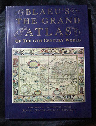
Blaeu's the Grand Atlas of the 17th Century World
Edité par Studio Editions, UK, 1997
ISBN 10 : 1858915880ISBN 13 : 9781858915883
Vendeur : SAVERY BOOKS, Brighton, East Sussex, Royaume-Uni
Evaluation du vendeur :
Livre
Hard Boards. Etat : Very Good. Etat de la jaquette : Very Good. HARDBACK IN JACKET 1997. Clean & tight. No inscriptions. Flat pages. Jacket is not torn & has only minor edge wear. Dispatched ROYAL MAIL FIRST CLASS with TRACKING next working day or sooner securely boxed in cardboard. ref M5695. Blaeu's the Grand Atlas of the 17th Century World. Studio Editions, UK.
-

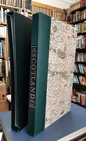
The Blaeu Atlas of Scotland - Scotland from Theatrum orbis terrarum, sive Atlas novus pars quinta, published by Joan Blaeu, Amsterdam, 1654
Edité par Birlinn Limited in association with National Library of Scotland, Edinburgh, 2006
ISBN 10 : 1841585858ISBN 13 : 9781841585857
Livre Edition originale
Hardcover. Etat : Very Good. First Edition Thus. 2006. 240pp. N0. 528 of 600 copies. "The Atlas contains 49 maps, many of them based on the original survey of Timothy Pont who toured the realm in the 1590s, during the reign of James VI, to produce maps of much of Scotland. In addition to the Pont Maps other material - both maps and chorographical - was collected over the next half century and sent to publisher Joan Blaeu in Amsterdam. This new edition of the "Blaeu Atlas of Scotland" includes all the original maps and text and, for the first time ever, contains a complete text in English, translated from the original Latin by I. C. Cunningham, a classics scholar and, formerly Keeper of Manuscripts, Maps and Music at the National Library of Scotland. This 21st-century edition of "Blaeu's Atlas of Scotland" will also contain an introduction by Professor Charles Withers, Professor of Historical Geography at the University of Edinburgh, and a translator's note from Ian C. Cunningham. This exclusive, numbered edition, is produced as close as possible to the format and size of the original and will contain images, courtesy of the National Library of Scotland taken directly from their original Blaeu Atlas of Scotland, first edition of 1654. This important publication is rare in that it not only provides a view and a record of Scotland 350 years ago but it is also of immense historical and geographical significance. This new edition will become a collector's piece for all those, worldwide, who are interested in maps and in Scotland's history." Casebound in quarter green cloth over illustrated paper covered boards within a protective slip case. Damage to the top right of the upper board (7mmx4mm loss) and a 4cmx3cm (barely perceptible) mark just below this. The book is otherwise in excellent condition with no inscriptions. The slipcase is in very good condition with a few bumps and scrapes. PLEASE NOTE: Very heavy book so extra will be needed for shipping to non-UK customers.
-
The Blaeu Atlas of Scotland - Scotland from Theatrum orbis terrarum, sive Atlas novus pars quinta, published by Joan Blaeu, Amsterdam, 1654
Edité par Birlinn Limited in association with National Library of Scotland, Edinburgh, 2006
ISBN 10 : 1841585858ISBN 13 : 9781841585857
Livre Edition originale
Hardcover. Etat : Very Good Plus. First Edition Thus. 2006. 240pp. "The Atlas contains 49 maps, many of them based on the original survey of Timothy Pont who toured the realm in the 1590s, during the reign of James VI, to produce maps of much of Scotland. In addition to the Pont Maps other material - both maps and chorographical - was collected over the next half century and sent to publisher Joan Blaeu in Amsterdam. This new edition of the "Blaeu Atlas of Scotland" includes all the original maps and text and, for the first time ever, contains a complete text in English, translated from the original Latin by I. C. Cunningham, a classics scholar and, formerly Keeper of Manuscripts, Maps and Music at the National Library of Scotland. This 21st-century edition of "Blaeu's Atlas of Scotland" will also contain an introduction by Professor Charles Withers, Professor of Historical Geography at the University of Edinburgh, and a translator's note from Ian C. Cunningham. This exclusive, numbered edition, is produced as close as possible to the format and size of the original and will contain images, courtesy of the National Library of Scotland taken directly from their original Blaeu Atlas of Scotland, first edition of 1654. This important publication is rare in that it not only provides a view and a record of Scotland 350 years ago but it is also of immense historical and geographical significance. This new edition will become a collector's piece for all those, worldwide, who are interested in maps and in Scotland's history." Casebound in quarter green cloth over illustrated paper covered boards within a protective slip case. Slight bump to the top of the spine. The book is otherwise in excellent condition with no inscriptions. The slipcase is in very good condition with a few bumps and scrapes. PLEASE NOTE: Very heavy book so extra will be needed for shipping to non-UK customers.
-

Ducato di Modena Regio et Capri, col Dominio della Carfagnana.
Edité par (A dam um ), 1640
Vendeur : Heilbronner Antiquariat - Michael Wahl, Heilbronn, Allemagne
Evaluation du vendeur :
Kupferstichkarte mit altem Grenzkolorit. Mit 2 altkolorierten, figürlichen bzw. ornamentalen Kartuschen. Ca. 40 x 46 cm. Rückseite bedruckt. Mit hinterlegten Einrissen im weißen Rand u.einem schmalen Randabriß. - Dekorative, breitrandige Karte. -.
