Montant total (1 article articles) :
Destination de la commande :

wyld james 1812 1887 (34 résultats)
Passer aux résultats principaux de la recherche
Type d'article
- Tous les types d'articles
- Livres (19)
- Magazines & Périodiques
- Bandes dessinées
- Partitions de musique
- Art, Affiches et Gravures (8)
- Photographies
- Cartes (3)
-
Manuscrits &
Papiers anciens (4)
Etat
Reliure
Particularités
Livraison gratuite
Pays
Evaluation du vendeur
-
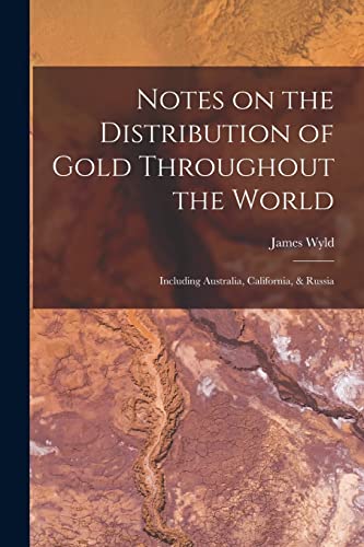
Notes on the Distribution of Gold Throughout the World: Including Australia, California, & Russia
Edité par Legare Street Press, 2021
ISBN 10 : 101532925XISBN 13 : 9781015329256
Livre
Etat : New.
Plus de choix d'achat de la part d'autres vendeurs sur AbeBooks
Offres neuf ŕ partir de EUR 16,04
-

Autograph Letter Signed ('(Thomas Hyde Hills) | John Bell & Co') from Thomas Hyde Hills of John Bell & Co [later John Bell & Croyden], Oxford Street, to the M.P. James Wyld, regarding jury exemption for pharmaceutical chemists.
Edité par 2 August ; 338 Oxford Street London, 1862
Vendeur : Richard M. Ford Ltd, London, Royaume-Uni
Membre d'association : ABA ILAB
Evaluation du vendeur :

Manuscrit / Papier ancien
12mo, 2 pp. Fifteen lines. Text clear and complete. Thanking Wyld for his 'Support on Thursday in the House of Commons, agreeing with the Lords' Amendment for the exemption of Pharmaceutical Chemists serving on Juries'. He hopes that the exemption will prove 'a Stimulus to Pharmaceutical education and thereby be of great service and increased safety to the Public'. Hills was Mayor of Cambridge from 1894 to 1895.
-
The Kingdom of France describing the New Limits according to the Treaty of Paris. Große altkolorierte Landkarte des Königreichs Frankreich nach dem Vertrag von Paris mit Innenkarte von Corsica 1885
Edité par London: James Wyld, 1835
Vendeur : historicArt Antiquariat & Kunsthandlung, Wiesbaden-Breckenheim, Allemagne
Evaluation du vendeur :
Carte Edition originale Signé
1. sehr große Landkarte auf rückseitig unbedrucktem Büttenkarton mit dekorativ abgesetztem Plattenrand, sehr detailreiche Landkarte, von alter Hand sehr schön flächenkoloriert, links unten französischer und englischer Meilenzeiger, rechts unten kleine Innenkarte der Insel Korsika im selben Maßstab wie die Hauptkarte, bildliche Darstellung ca. 52 x 62 cm, Blattgröße ca. 58 x 77 cm, geglättete Mittelfalz, ansonsten sauber und sehr gut erhalten, selten - großer und/oder schwerer Artikel mit zusätzlichen Kosten für Versand und Versicherung - heavy and/or oversized item with additional costs for shipping and insurance - please ask us before you order this article 2100 gr.
-
Autograph Letter Signed ('Dudley Coutts Stuart | Vice-Presid[ent]') from Lord Dudley Stuart to James Wyld, Member of Parliament for Bodmin, as Vice-President of the Literary Association of the Friends of Poland, on behalf of a Polish refugee.
Edité par 3 April ; on letterhead of the Literary Association of the Friends of Poland Sussex Chambers Duke Street St. James's, 1840
Vendeur : Richard M. Ford Ltd, London, Royaume-Uni
Membre d'association : ABA ILAB
Evaluation du vendeur :
Manuscrit / Papier ancien
12mo, 3 pp. Text clear and complete. Worn and aged, with pinholes and unobtrusive repair to closed tears. The 'kindness' Wyld has 'always shewn to the Poles' makes Stuart sure that he will attend to his recommendation of 'Captain Thadeus Grubski, one of the Polish Refugees who bears a very high character'. By employing him Wyld would 'render an essential service to a deserving man much in need of it, and confer a favor as well on this association in general', and on Stuart in particular.
-
Autograph Letter Signed from ' Bell' of Hastings, written while dying, to James Wyld, member of Parliament for Bodmin, regarding a Parliamentary Bill on the sale of poisons.
Edité par 28 February ; Hastings, 1859
Vendeur : Richard M. Ford Ltd, London, Royaume-Uni
Membre d'association : ABA ILAB
Evaluation du vendeur :
Manuscrit / Papier ancien
12mo, 4 pp. 64 lines. Text clear and complete. Good, on lightly-aged paper. He was 'mistaken about the Marylebone Election - Having been a prisoner so much lately' he had 'not seen many electors & those whom I saw thought it was too late & regretted to see a split in the liberal party'. He 'did not influence a single vote being too unwell to take any part in it'. He 'left town to escape the excitement'. He has 'already troubled our new Representative with a little Parliamentary Business', and is sending Wyld 'some documents on the same subject by the Book post'. He hopes to be in London in the next few days, and hopes to have 'a few minutes conversation [.] to whisper any explanation that may be required'. He lists the documents, which include 'the Pharmaceutical Journal for March with two articles on the Sale of Poisons Bill. (the first & second articles -)' and 'a circular sent by the Poison Committee of the Pharml. Society to our correspondents in the Country'. 'Mr. Walpole declines to insert [certain clauses] in his Bill reserving that part of the question for another Bill which I fear will not be passed during the remains of my life'. In December 1854 Bell had stood unsuccessfully in the Liberal interest at a by-election for the borough of Marylebone.
-

The Prussian Government of Stralsund (formerly Swedish Pomerania)
Edité par London. 1853, 1853
Vendeur : Peter Harrington. ABA/ ILAB., London, Royaume-Uni
Membre d'association : ABA ILAB PBFA
Evaluation du vendeur :
Wyld maintained the high standard of graphic and factual excellence that had been established by his predecessor and his maps are among the finest published in the early nineteenth century. Published by James Wyld, A New General Atlas of Modern Geography Consisting of a Complete Collection of Maps of the Four Quarters of the Globe; Delineating their Physical Features and Coloured to show the Limits of their respective states. Copper engraving. Original colour. Very good condition. Original fold line as issued. 58.5 x 66.5 cm.
-
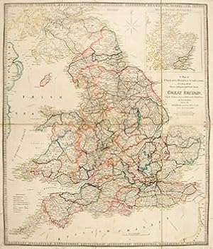
A Map of England, Wales, & Scotland describing all the Direct and principal Cross Roads in Great Britian, with the Distances measured between the Market Towns and From London.
Edité par Published by James Wyld, Charing Cross East, Geographer To Her Majesty. London. A New General Atlas of Modern Geography Consisting of a Complete Collection of Maps of the Four Quarters of the Globe; Delineating their Physical Features and Coloured to show the Limits of their respective states. c1853, 1853
Vendeur : Peter Harrington. ABA/ ILAB., London, Royaume-Uni
Membre d'association : ABA ILAB PBFA
Evaluation du vendeur :
A detailed map of England, Wales and southern Scotland, with inset of the north of Scotland. James Wyld was successor to William Faden, one of the luminaries of late eighteenth century publishing in England. Wyld maintained the high standard of graphic and factual excellence that had been established by his predecessor and his maps are among the finest published in the early nineteenth century. Copper engraving. Original outline colour. Good condition. Original fold lines as issued. On two sheets dissected and joined with linen. Several small tears along margins. 62 x 73 cm.
-
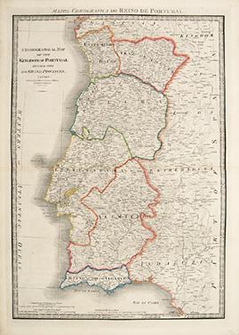
Chronographical Map of the Kingdom of Portugal Divided into its Grand Provinces.
Edité par Published by James Wyld, Charing Cross East, Geographer To Her MAjesty. London. A New General Atlas of Modern Geography Consisting of a Complete Collection of Maps of the Four Quarters of the Globe; Delineating their Physical Features and Coloured to show the Limits of their respective states. c1853, 1853
Vendeur : Peter Harrington. ABA/ ILAB., London, Royaume-Uni
Membre d'association : ABA ILAB PBFA
Evaluation du vendeur :
A large and detailed map of Portugal. James Wyld was successor to William Faden, one of the luminaries of late eighteenth century publishing in England. Wyld maintained the high standard of graphic and factual excellence that had been established by his predecessor and his maps are among the finest published in the early nineteenth century Copper engraving. Original outline colour. Very good condition. 54 x 77 cm (21 x 30 inches).
-
Map Of The Ottoman Empire The Black Sea And The Frontiers of Russia And Persia.
Edité par London: November 9th, 1853., 1853
Vendeur : D & E LAKE LTD. (ABAC/ILAB), Toronto, ON, Canada
Membre d'association : ABAC ILAB
Evaluation du vendeur :

Hardcover. 402 x 575 mm. hand-coloured folding engraved sectionalized map, mounted on linen. original cloth, printed paper label on upper cover, printed sheet of ads on verso of one section. (dampstaining visible on linen but not map, rear cover dampstained & slightly warped).
-

Map of the Kingdom of Denmark including the Dutchies of Holstein and Lauenburg
Edité par Published by James Wyld, Charing Cross East, Geographer To Her Majesty. London. A New General Atlas of Modern Geography Consisting of a Complete Collection of Maps of the Four Quarters of the Globe; Delineating their Physical Features and Coloured to show the Limits of their respective states. 1853, 1853
Vendeur : Peter Harrington. ABA/ ILAB., London, Royaume-Uni
Membre d'association : ABA ILAB PBFA
Evaluation du vendeur :
Wyld maintained the high standard of graphic and factual excellence that had been established by his predecessor and his maps are among the finest published in the early nineteenth century. Copper engraving. Original colour. Very good condition. Original fold line as issued. 53.5 x 73cm.
-

Etat : ACEPTABLE. Spanish Peninsula Battles Formato (cm): 57x76.
-
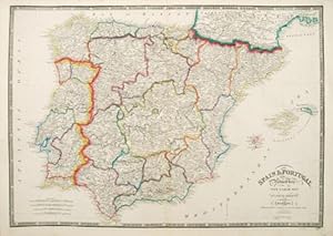
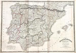
Spain and Portugal
Edité par Published by James Wyld, Charing Cross East, Geographer To Her Majesty. London. A New General Atlas of Modern Geography Consisting of a Complete Collection of Maps of the Four Quarters of the Globe; Delineating their Physical Features and Coloured to show the Limits of their respective states. 1853, 1853
Vendeur : Peter Harrington. ABA/ ILAB., London, Royaume-Uni
Membre d'association : ABA ILAB PBFA
Evaluation du vendeur :
Wyld maintained the high standard of graphic and factual excellence that had been established by his predecessor and his maps are among the finest published in the early nineteenth century. Copper engraving. Original colour. Very good condition. Original fold lines as issued. 77.5 x 56 cm.
-
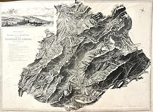
Movement against the French Troops occupying the Position of Guarda on the 29 th March 1811
Edité par Londres, 1840
Art / Affiche / Gravure
Etat : ACEPTABLE. [Un] Mapa titulado "Spanish Peninsula Battles", obra deJames Wyld (1812-1887), geógrafo y vendedor de mapas británico, además de miembro del Parlamento Británico, más conocido por su atracción "Wyld's Great Globe", un globo gigante de 8,39 metrosde diámetro, era hueco y que contenía una escalera y plataformas elevadas a las que el público podía subir para ver la superficie de la tierra en su interior cóncavo, con cadenas montańosas y ríos a escala elaborados en yeso. En margen superior izquierdo pequeńa vista "Sketch of the face of the country about Guarda". Desperfecto en zona central superior de 2 cm. Formato (cm): 83x61.
-

Affair of Garris, 16Th Feb. 1814 / Affair near the town of Aire, 2nd March 1814 / Movement of the Allies .near Tarbes on the 20Th. of March 1814
Edité par Londres, 1840
Art / Affiche / Gravure
Etat : ACEPTABLE. Spanish Peninsula Battles Formato (cm): 84x69.
-

Attack made by the Allies under the Marquis of Wellington position on the fortified position of the Nivelle, occupied by the French Army commanded by Marshal Soult, Upon the 10th 1813
Edité par Londres, 1840
Art / Affiche / Gravure
Etat : ACEPTABLE. Spanish Peninsula Battles Formato (cm): 107x69.
-
Autograph Letter Signed from Abbott Lawrence, United States Minister to the Court of St James, to James Wyld, Member of Parliament for Bodmin, concerning his gift to the American people of his 'New Map of Central America'.
Edité par 28 February ; 138 Piccadilly London, 1850
Vendeur : Richard M. Ford Ltd, London, Royaume-Uni
Membre d'association : ABA ILAB
Evaluation du vendeur :
Manuscrit / Papier ancien
4to, 1 p. Text clear and complete. In original envelope, addressed by Lawrence and with his red wax seal and frank ('Abbott Lawrence'), 'To | James Wyld Esqre M.P. | &c &c &c | Charing Cross East'. On aged and stained paper. He thanks him for his 'New Map of Central America', which he will 'transmit to Washington, where I believe it will be thought, that you have made ample provision for the "Mosquito Indians"'. The following year Wyld would erect his 'Great Globe' in Leicester Square, where it would remain until 1862.
-
Sketch illustrative of the operations in the vicinity of Bayonne during the winter of 1813
Edité par Londres, 1840
Art / Affiche / Gravure
Etat : ACEPTABLE. Spanish Peninsula Battles Incluye Guetaria, Ahetze, Arautz, Ustaritz, Biarritz. Formato (cm): 69x84.
-

Etat : ACEPTABLE. - James Wyld. Geographer to the Queen. - Published by James Wyld.Charing Cross. London - March 17th. 1885 Entelado, plegado y en cuarterones Formato (cm): 65x41.
-
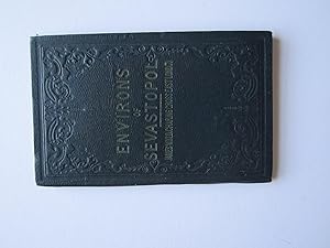
The Environs of Sevastopol with the Batteries & Approaches by James Wyld,
Edité par James Wyld, London, 1854
Vendeur : Angelika C. J. Friebe Ltd. - MapWoman, Dorking, Royaume-Uni
Membre d'association : ABA ILAB
Evaluation du vendeur :
Carte
Soft cover. Etat : Very Good. lithographed map with original colouring; map overall 68 x 49,5 cm, folds down to 17,5 x 11,5 cm. folding map on cloth; folds as issued; some folds discoloured; some small holes in crossfolds; list of publications on verso; some faint spotting and foxing; slightly cxropped lower margin; o/w vg cond. cover: dark blue cloth; some wear and tear; some staining. A detailed and very attractive plan of the Siege of Sebastopol from this map s 2nd edition, showing the positions of the English, French, Turkish and Russian Armies. The inset of the battle of Eupatoria is missing in this earlier edition but shows instead A List of New Publications . The Russian Tsar s Black Sea Fleet was stationed in Sebastopol and a threat to the Mediterranean. The Russian army withdrew, leaving Sebastopol under siege by the Allied armies. The Siege of Sebastopol was the pivotal struggle for the Russian port and was the final chapter in the Crimean War.
-

Map of Part of the Western Coast of Africa Extending from the Isles De Loss to Sherboro Island.
Edité par London. 1853, 1853
Vendeur : Peter Harrington. ABA/ ILAB., London, Royaume-Uni
Membre d'association : ABA ILAB PBFA
Evaluation du vendeur :
Wyld maintained the high standard of graphic and factual excellence that had been established by his predecessor and his maps are among the finest published in the early nineteenth century. Copper engraving. Original colour. Very good condition. Original fold lines as issued. On two sheets dissected and joined with linen. 101 x 67.5 cm.
-
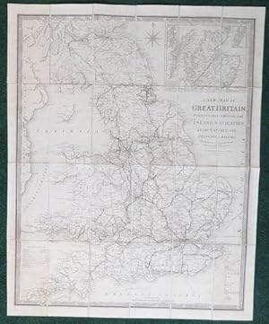
A New Map of Great Britain; Particularly Shewing the Inland Navigation, by the Canals, and Principal Rivers.
Edité par Jas. Wyld, London. Charing Cross East.
Vendeur : Madoc Books (ABA-ILAB), Llandudno, CONWY, Royaume-Uni
Membre d'association : ABA ILAB IOBA PBFA
Evaluation du vendeur :
Livre
Soft cover. Etat : Very Good. VG, c1850, uncommon. Title continues: with the railways finished and in progress, and the principal and secondary stations. 24 panels, with an inset supplement of Scotland on a reduced scale, with the Shetland & Orkneys to the top corners, and the Explanation to the bottom left corner, with its printed contemporary slip case, map is 63*77.7cm, inside printed borders 69.6*55.6. folded 19.5*10.5, in the slip case 20.3*11.5cms. Map was originally published in 1838?, this map, because of the Charing Cross East was probably published c1850? Wyld, mapseller, publisher, map engraver, lithographer and globemaker. Geographer to Queen Victoria. (see Worms & Baynton-Williams - British Map Engravings p741).
-
Spain and Portugal Reduced from The Large Map in Four Sheets
Edité par Londres, 1838
Art / Affiche / Gravure
Etat : ACEPTABLE. [Un] Mapa representando la Península Ibérica y las Islas Baleares, edición reducida del mapa en cuatro hojas dede James Wyld (1812-1887) y con énfasis en los caminos y rutas terrestres. James Wyld fue un geógrafo y vendedor de mapas británico, además de miembro del Parlamento Británico, más conocido por su atracción "Wyld's Great Globe", un globo gigante de 8,39 metros de diámetro, era hueco y que contenía una escalera y plataformas elevadas a las que el público podía subir para ver la superficie de la tierra en su interior cóncavo, con cadenas montańosas y ríos a escala elaborados en yeso. Estampado en negro con demarcaciones a color. Formato (cm): 67x84.
-
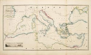
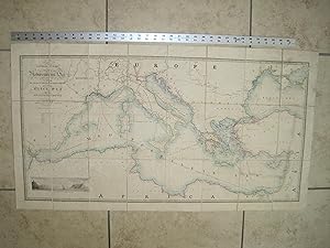
General Chart of the Mediterranean Sea Including the Gulf of Venice, Archipelago and part of the Black Sea with the Steam packet Routes.
Edité par Published by James Wyld, Charing Cross East, Geographer To Her Majesty. London. A New General Atlas of Modern Geography Consisting of a Complete Collection of Maps of the Four Quarters of the Globe; Delineating their Physical Features and Coloured to show the Limits of their respective states. 1853, 1853
Vendeur : Peter Harrington. ABA/ ILAB., London, Royaume-Uni
Membre d'association : ABA ILAB PBFA
Evaluation du vendeur :
A large detailed map of the Mediterranean Islands. A finely engraved view of the entrance of Gibraltar Bay is in the lower left corner. James Wyld was successor to William Faden, one of the luminaries of late eighteenth century publishing in England. Wyld maintained the high standard of graphic and factual excellence that had been established by his predecessor and his maps are among the finest published in the early nineteenth century. Copper engraving. Original colour. Very good condition. Original fold lines as issued. 48.5 x 93.5 cm.
-
General Chart of the Mediterranean Sea Including the Gulf of Venice, Archipelago and Part of the Black Sea with the Steam Packet Routes
Edité par James Wyld, Geographer to Her Majesty, Charing Cross East, London, 1853
Edition originale
Paperback. Etat : Very Good condition. First Edition. London: James Wyld, Geographer to Her Majesty, Charing Cross East, 1853. Very Good condition (only a little light soil) SEE PHOTOS. This huge detailed map of the Mediterranean measures 99.5cm by 54cm when unfolded. The image itself is 93.5cm by 47.5cm. There is a finely engraved view of the entrance of Gibraltar Bay in the lower left corner. The map is a linen-backed copper engraving with original hand coloring. The map has handsome marbled paper endsheets and when folded-up measures 18cm by 12.5cm. SEE PHOTOS. Published by James Wyld, Geographer to Her Majesty, Charing Cross East, London. A New General Atlas of Modern Geography Consisting of a Complete Collection of Maps of the Four Quarters of the Globe; Delineating their Physical Features and Coloured to Show the Limits of Their Respective States [1853]. First Edition. Linen-backed hand-colored map. Very Good condition. 99.5cm by 54cm when unfolded. Great Packaging, Fast Shipping.
-
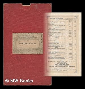
New Post Map of Central Europe Exhibiting the Great and Secondary Routes with the Various Stations Where Relays Are Obtained Showing Also the Distance between Each According to the Measure Used in the Respective Countries.
Edité par London (Regent Street) ; James Gardner [Agent For The Sale Of The Ordnance Survey], 1827
Particularly well-preserved with the coloring surprisingly vibrant. Red buckram case (paper-labeled) somewhat worn and dust-dulled as with age. Scans etc. On request. ; 0 pages; Description: col. Map, linen backed 126 x 95 cm. Fold. In cover 23 x 15 cm. Scale ca. 1: 650, 000. Relief shown by hachures. Subjects: Europe--Maps--Early 19th Century. 1 Kg. Published June 1st 1827 [additions to 1847].
-
A Map of the Province of Upper Canada, describing All The New Settlements, Townships, &c. With The Countries Adjacent, From Quebec To Lake Huron London, Published by Jas. Wyld, Geographer to Her Majesty, Charing Cross East 1838.
Edité par [London: 1838]., 1838
Vendeur : D & E LAKE LTD. (ABAC/ILAB), Toronto, ON, Canada
Membre d'association : ABAC ILAB
Evaluation du vendeur :
No Binding. Etat : Good. No Jacket. 22 1/2 x 34 inches (57 x 86.1 cm). original colour. backed on linen, as issued (narrow brown stain near horizontal fold & one section of linen stained). cloth slipcase (bit frayed) original printed label. First issued in 1800 by Smyth and subsequently revised by Wyld, this map of Upper Canada contains detailed information on the counties, districts, townships, transportation systems, place-names and northern Ontario ('Great Tract of Wilderness') &c. It also includes portions of Quebec, Michigan Territory, New York, Pennsylvania. The 1838 issue includes additional rivers, lakes, place-names, roads and a railway from London to Hamilton. Winearls, Mapping Upper Canada, 30.6b. Tooley, The Mapping of America, 82(e), p. 102.
-
Etat : ACEPTABLE. Published by Ja.s Wyid Geographer to the Quuen and to HRH. Prince Albert. Charing Cross East. London 1840 Dividido en 2 hojas de 61x98 cms. C/una. Restaurado. Marcas de plegado en el doblez. Formato (cm): x2x61x98.
-

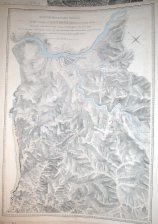
INDIA: MAP OF INDIA CONSTRUCTED WITH GREAT CARE AND RESEARCH FROM ALL THE LATEST AUTHORITIES AND INTENDED MORE PARTICULARLY TO FACILITATE A REFERENCE TO THE CIVIL AND MILITARY STATIONS. DEDICATED TO SIR JAMES RIVETT CARNAC, BART. ARRANGED UNDER
Edité par London, ., 1841
Vendeur : Antiquariat Dasa Pahor GbR, München, Allemagne
Membre d'association : ILAB VDA
Evaluation du vendeur :

Carte
Steel engraving, varnished with original hand colour, remounted during the 20th Century on fresh linen, with old lower wooden roller and modern upper roller (Good, map with varnish evenly toned and lightly cracked but forming a nice patina, the remounting of linen and replacement roller was executed evidently with considerable skill and expense), map: 96 x 68.5, plus rollers approximately 78 cm long. A fine early, edition of example of James Wyld's highly important wall map of India, made under the direction of the artist and banker Robert Melville Grindlay, attractively mounted in wall map format with rollers. This fascinating map was perhaps the most influential and practically useful map of all of India produced during the mid-19th Century, a critical period in the history of the Subcontinent. The map is very well designed, with vast amounts of detail clearly expressed, with a wise economy of space. By this time, almost all of India was either directly or indirectly under the control of the British East India Company (EIC), who would govern the subcontinent until 1858. India is shown to be divided into various administrative units: the vast areas outlined in pink are under direct EIC rule, while the various princely states (autonomous Indian nations under British protection) are outlined in a variety of hues. The present map was issued in 1841, during something of a lull between two especially ine periods of British military activity and conquest in India. Looking back, beginning in the 1790s, the EIC dramatically intensified its designs towards creating an empire spanning India. After decades of intermittent conflict, the British finally crushed the Sultanate of Mysore during the Fourth Anglo-Mysore War (1798-9). The British annexed the Kanara Coast and made what remained of Mysore a puppet state. Hyderabad became a client state of the Company in 1800 and, in 1801, the British assumed practical control over the Carnatic, with the nawab maintaining only nominal authority. The Kingdom of Travancore, occupying the southern part of the Malabar Coast, became an EIC client state around the same time. The EIC also managed to vanquish the mighty Maratha Confederacy, which during the mid-18th Century had become the dominant force in central and western India. During the three Anglo-Maratha Wars, fought between 1775 and 1818, the power of this great empire was progressively eroded. Upon the conclusion of the Third Anglo-Maratha?War (1817-1818), the British acquired practical control of all of India south of the Sutlej River (a major tributary of the Indus), with the areas newly added to its sphere including modern Rajasthan, Gujarat, Maharashtra and Madhya Pradesh. While some of these . SEE OUR WEB PAGE FOR LONGER DESCRIPTION.References: Cf. OCLC (1840 ed.): 673203526.
-
Map of the United States and the Provinces of Upper & Lower Canada, New Brunswick, and Nova Scotia, Compiled from the latest Surveys and other authentic information.
Edité par [London: James Wyld]: 1846, 1846
Vendeur : Arader Galleries - AraderNYC, New York, NY, Etats-Unis
Evaluation du vendeur :
Fine folding engraved wall map in four separate sheets each laid down on cartographic linen in sixteen sections edged with green silk (total size: 52 x 79 inches), with insets of East Florida and a General Map of North America lower right, all with original hand-colour in outline. With printed paper sectional labels and an advertisement to verso. Original purple diced cloth slipcase with printed paper label on the front cover and side (unevenly faded to brown, extremities a bit worn). A FINE EXAMPLE OF WYLD'S MOST AMBITIOUS CARTOGRAPHICAL PRODUCTION, RARE, not in Phillips, Wheat, etc., nor listed in the OCLC. "This large-scale map of the United States and Canada shows the United States at the outset of the Mexican War, but before the Treaty of Guadalupe Hidalgo. Nevertheless, Texas east of 102°W longitude is shown. As if to suggest the transitional and ambiguous state of the western boundary of Texas, Wyld used a very light shading for the western border, which runs along the Nueces, "Guadeloupe," and Colorado Rivers. Houston is shown, but Austin is not. The inset "A General Map of North America", shows Texas as part of the United States, and here the border is placed at the Nueces. Of Western interest is the northwestern section, showing large-scale the Northwestern Territory and the part of northern Missouri Territory that is today Montana and Wyoming" (Dorothy Sloan).