
Montant total (1 article articles) :
Destination de la commande :

global map (44 résultats)
Passer aux résultats principaux de la recherche
Type d'article
- Tous les types d'articles
- Livres (40)
- Magazines & Périodiques
- Bandes dessinées
- Partitions de musique
- Art, Affiches et Gravures
- Photographies
- Cartes (4)
-
Manuscrits &
Papiers anciens
Etat
Reliure
Particularités
- Edition originale (1)
- Signé
- Jaquette
- Avec images (21)
- Sans impression ŕ la demande
Pays
Evaluation du vendeur
-
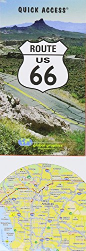
Route US 66 (Quick Access)
Edité par Global Graphics / GM Johnson Maps, 1999
ISBN 10 : 0918505402ISBN 13 : 9780918505408
Livre
Etat : Very Good. Global Graphics (illustrateur). Very Good Condition. Five star seller - Buy with confidence!.
Plus de choix d'achat de la part d'autres vendeurs sur AbeBooks
Offres neuf ŕ partir de EUR 27,67
Offres d'occasion ŕ partir de EUR 6,16
Trouvez également Couverture souple
-

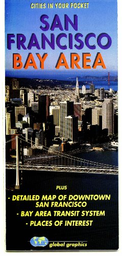
San Francisco Bay Area, California Regional Map
Edité par Global Graphics / GM Johnson Map, 2019
Vendeur : Half Price Books Inc., Dallas, TX, Etats-Unis
Evaluation du vendeur :

map. Etat : Good. Connecting readers with great books since 1972! Used books may not include companion materials, and may have some shelf wear or limited writing. We ship orders daily and Customer Service is our top priority!.
-
Paperback. Etat : Very Good. The book has been read, but is in excellent condition. Pages are intact and not marred by notes or highlighting. The spine remains undamaged.
-
Befriedigend/Good: Durchschnittlich erhaltenes Buch bzw. Schutzumschlag mit Gebrauchsspuren, aber vollständigen Seiten. / Describes the average WORN book or dust jacket that has all the pages present.
-
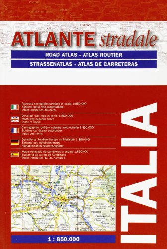
Atlante stradale tascabile 1:850.000
Edité par Global Map, 2010
ISBN 10 : 8879143166ISBN 13 : 9788879143165
Livre
Gut/Very good: Buch bzw. Schutzumschlag mit wenigen Gebrauchsspuren an Einband, Schutzumschlag oder Seiten. / Describes a book or dust jacket that does show some signs of wear on either the binding, dust jacket or pages.
-
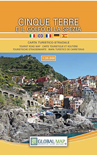
Cinque Terre e il Golfo di la Spezia
Edité par Global Map, 2017
ISBN 10 : 8833031438ISBN 13 : 9788833031439
Livre
Befriedigend/Good: Durchschnittlich erhaltenes Buch bzw. Schutzumschlag mit Gebrauchsspuren, aber vollständigen Seiten. / Describes the average WORN book or dust jacket that has all the pages present.
-
Etat : Good. Book is in Used-Good condition. Pages and cover are clean and intact. Used items may not include supplementary materials such as CDs or access codes. May show signs of minor shelf wear and contain limited notes and highlighting.
Plus de choix d'achat de la part d'autres vendeurs sur AbeBooks
Offres neuf ŕ partir de EUR 41,92
Offres d'occasion ŕ partir de EUR 18,83
-
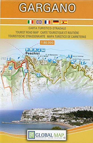
Gargano, Italy - Tourist Road Map / Carta Turistico-Stradale (English, Spanish, French, Italian and German Edition)
Edité par Global Map S.r.l., 2017
ISBN 10 : 8833030040ISBN 13 : 9788833030043
Livre
Etat : New. Buy with confidence! Book is in new, never-used condition.
-
Los Angeles and Orange County Souvenir Book
Edité par Global Graphics Maps LLC, 2005
ISBN 10 : 0918505658ISBN 13 : 9780918505651
Vendeur : Better World Books Ltd, Dunfermline, Royaume-Uni
Evaluation du vendeur :
Livre
Etat : Good. Ships from the UK. Former library book; may include library markings. Used book that is in clean, average condition without any missing pages.
-
San Francisco Bay Area, California Regional Map
Edité par Global Graphics / GM Johnson Maps, 2019
ISBN 10 : 0918505135ISBN 13 : 9780918505132
Livre
Etat : Good. Good condition. This is the average used book, that has all pages or leaves present, but may include writing. Book may be ex-library with stamps and stickers.
-
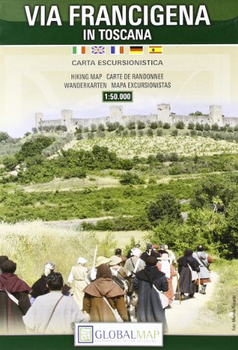
Via Francigena in Toscana
Edité par Global Map 28 J, 2001
ISBN 10 : 8879145029ISBN 13 : 9788879145022
Livre
Map. Etat : Very Good. Via Francigena in Toscana This book is in very good condition and will be shipped within 24 hours of ordering. The cover may have some limited signs of wear but the pages are clean, intact and the spine remains undamaged. This book has clearly been well maintained and looked after thus far. Money back guarantee if you are not satisfied. See all our books here, order more than 1 book and get discounted shipping. .
Plus de choix d'achat de la part d'autres vendeurs sur AbeBooks
Offres d'occasion ŕ partir de EUR 39,79
-
The global map.
Edité par Global Map Co., [ca. 1941]., Minneapolis, MN:, 1941
Vendeur : Zephyr Used & Rare Books, Vancouver, WA, Etats-Unis
Membre d'association : ABAA CBA ESA ILAB
Evaluation du vendeur :
Edition originale
Oblong folio (22.5 x 11.25 in.) Two rotating wheels each showing hemisphere projection maps, which are attached to a thick brown base, w/ printed labels on front cover, original rivets still present, printed paper label and instructions on verso (some rubbing & edgewear, minor foxing & scuffing), still a G exemplar. First edition of this fascinating and scarce global map which allows the user to view steamship, or airline distance routes, as well as the principal railroads. The global map was designed so that opposite halves of the earth's surface could be rotated and synchronized enabling continuous and accurate spherical relationships across any point on the rotating maps. The label on the back lists the area in square miles, and population totals of the world. The map is dated to around 1941 because of the inclusion of Vichy France, the government allowed by the Nazi occupiers after the fall of France in 1940.
-

Terre d'Otrante Par Mr. Blaeu.
Edité par Artist: Mortier/ Blaeu W Peter ( - 1711 ) Amsterdam ; issued in: Amsterdam ; ca: 1690; - Pieter Mortier (1661?1711) was an 18th-century mapmaker and engraver from the Northern Netherlands Mortier had a partnership with Johannes Covens I (1697-1774) and founded the map publishing company Covens & Mortier (1721-1866) Mortier being French himself had easy access to French cartographers such as De L'Isle Sanson Jaillot de Fer and De Wit Consequently much of Mortier's business was built upon leveraging the sophisticated Dutch printing establishment to issue embellished high quality editions of previously contemporary French maps In the greater context of global cartography this was a significant advantage as most Dutch map publishes had at this, 1661
Vendeur : Antique Sommer& Sapunaru KG, München, Allemagne
Membre d'association : ILAB VDA
Evaluation du vendeur :

Technic: Copper print; colorit: original colored; condition: Perfect condition, size (in cm): 38,5 x 49,5 cm; - Map shows Terra d'Otranto with three magnificent heraldic cartouches (coats of arms of the Kingdom of Naples and Terra d'Otranto), a compass rose and two sailing ships. Terra d'Otranto was an ancient administrative unit in southern Italy, today it belongs to Puglia. With typical missing parts (2 corners) at the printing plate.
-
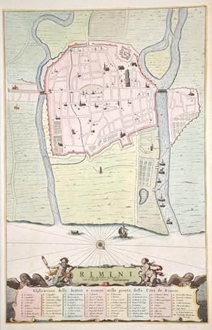
Rimini
Edité par Artist: Mortier Peter ( - 1711 ) Amsterdam ; issued in: Amsterdam ; ca: 1700; - Pieter Mortier (1661?1711) was an 18th-century mapmaker and engraver from the Northern Netherlands Mortier had a partnership with Johannes Covens I (1697-1774) and founded the map publishing company Covens & Mortier (1721-1866) Mortier being French himself had easy access to French cartographers such as De L'Isle Sanson Jaillot de Fer and De Wit Consequently much of Mortier's business was built upon leveraging the sophisticated Dutch printing establishment to issue embellished high quality editions of previously contemporary French maps In the greater context of global cartography this was a significant advantage as most Dutch map publishes had at this point fal, 1661
Vendeur : Antique Sommer& Sapunaru KG, München, Allemagne
Membre d'association : ILAB VDA
Evaluation du vendeur :
Technic: Copper print; colorit: colored; condition: Very good, size (in cm): 46 x 30 cm; - City map of Rimini, below title cartouche with index.
-
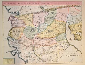
Macedonia Alexandri Magni Patria.
Edité par Artist: Mortier Peter ( - 1711 ) Amsterdam ; issued in: Amsterdam ; ca: 1730; - Pieter Mortier (1661?1711) was an 18th-century mapmaker and engraver from the Northern Netherlands Mortier had a partnership with Johannes Covens I (1697-1774) and founded the map publishing company Covens & Mortier (1721-1866) Mortier being French himself had easy access to French cartographers such as De L'Isle Sanson Jaillot de Fer and De Wit Consequently much of Mortier's business was built upon leveraging the sophisticated Dutch printing establishment to issue embellished high quality editions of previously contemporary French maps In the greater context of global cartography this was a significant advantage as most Dutch map publishes had at this point fal, 1661
Vendeur : Antique Sommer& Sapunaru KG, München, Allemagne
Membre d'association : ILAB VDA
Evaluation du vendeur :
Technic: Copper print; colorit: original colored; condition: Perfect condition, size (in cm): 43,5 x 55 cm; - Map shows historical Greek Macedonia or Macedonia with compass rose and mileage indicator.
-
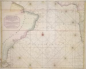
Carte de la mer Meridional Contenant un partie des Costes de l Afrique et de L Amerique meridionale.
Edité par Artist: Mortier Peter ( - 1711 ) Amsterdam ; issued in: Amsterdam ; ca: 1705; - Pieter Mortier (1661?1711) was an 18th-century mapmaker and engraver from the Northern Netherlands Mortier had a partnership with Johannes Covens I (1697-1774) and founded the map publishing company Covens & Mortier (1721-1866) Mortier being French himself had easy access to French cartographers such as De L'Isle Sanson Jaillot de Fer and De Wit Consequently much of Mortier's business was built upon leveraging the sophisticated Dutch printing establishment to issue embellished high quality editions of previously contemporary French maps In the greater context of global cartography this was a significant advantage as most Dutch map publishes had at this point fal, 1661
Vendeur : Antique Sommer& Sapunaru KG, München, Allemagne
Membre d'association : ILAB VDA
Evaluation du vendeur :
Carte
Technic: Copper print; colorit: original colored; condition: Minor restorations along the orig. outline colours, size (in cm): 47,5 x 60; - Map shows the Atlantic with the coast of South America and the caost of the southern part of Africa.; - Special feature: From Mortier, Suite du Neptune Francois.
-
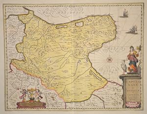
Capitanate ou Mesapiae et Iapygiae
Edité par Artist: Mortier/ Blaeu W Peter ( - 1711 ) Amsterdam ; issued in: Amsterdam ; ca: 1690; - Pieter Mortier (1661?1711) was an 18th-century mapmaker and engraver from the Northern Netherlands Mortier had a partnership with Johannes Covens I (1697-1774) and founded the map publishing company Covens & Mortier (1721-1866) Mortier being French himself had easy access to French cartographers such as De L'Isle Sanson Jaillot de Fer and De Wit Consequently much of Mortier's business was built upon leveraging the sophisticated Dutch printing establishment to issue embellished high quality editions of previously contemporary French maps In the greater context of global cartography this was a significant advantage as most Dutch map publishes had at this, 1661
Vendeur : Antique Sommer& Sapunaru KG, München, Allemagne
Membre d'association : ILAB VDA
Evaluation du vendeur :
Technic: Copper print; colorit: original colored; condition: Perfect condition, size (in cm): 38,5 x 49,5 cm; - Splendid map showing the province of Foggia in the region of Apulia. Furthermore a title cartouche and a cartouche with the coat of arms of Capitanata, a compass rose and two sailing ships. (Capitanata, created by Frederick II of Hohenstaufen, corresponds to the Daunia of antiquity and the modern province of Foggia).; - Special feature: Royal edition, heightened with gold.
-
Carte particuliere des costes du Cap de Bonne Esperance
Edité par Artist: Mortier Peter ( - 1711 ) Amsterdam ; issued in: Amsterdam ; ca: 1700; - Pieter Mortier (1661?1711) was an 18th-century mapmaker and engraver from the Northern Netherlands Mortier had a partnership with Johannes Covens I (1697-1774) and founded the map publishing company Covens & Mortier (1721-1866) Mortier being French himself had easy access to French cartographers such as De L'Isle Sanson Jaillot de Fer and De Wit Consequently much of Mortier's business was built upon leveraging the sophisticated Dutch printing establishment to issue embellished high quality editions of previously contemporary French maps In the greater context of global cartography this was a significant advantage as most Dutch map publishes had at this point fal, 1661
Vendeur : Antique Sommer& Sapunaru KG, München, Allemagne
Membre d'association : ILAB VDA
Evaluation du vendeur :
Technic: Copper print; colorit: original colored; condition: Some folds partly restored, left margin replaced, size (in cm): 59 x 80; - Map shows South Africa and the Cap of good hope; - Special feature: 3 maps on one sheet.
-
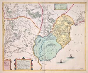
Paraguaria vulgo Paraguay. Cum adjacentibus.
Edité par Artist: Mortier Peter ( - 1711 ) Amsterdam ; issued in: Amsterdam ; ca: 1695; - Pieter Mortier (1661?1711) was an 18th-century mapmaker and engraver from the Northern Netherlands Mortier had a partnership with Johannes Covens I (1697-1774) and founded the map publishing company Covens & Mortier (1721-1866) Mortier being French himself had easy access to French cartographers such as De L'Isle Sanson Jaillot de Fer and De Wit Consequently much of Mortier's business was built upon leveraging the sophisticated Dutch printing establishment to issue embellished high quality editions of previously contemporary French maps In the greater context of global cartography this was a significant advantage as most Dutch map publishes had at this point fal, 1661
Vendeur : Antique Sommer& Sapunaru KG, München, Allemagne
Membre d'association : ILAB VDA
Evaluation du vendeur :
Technic: Copper print; colorit: original colored; condition: Very good, size (in cm): 45 x 54,5; - Map shows Uruguay, partly Paraguay, east part of Argentinia and Rio do sul ( Brasilia).
-
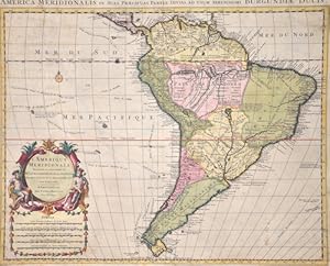
L'Amerique Meridionale Dressee sur les Observations de.
Edité par Artist: Mortier Peter ( - 1711 ) Amsterdam ; issued in: Amsterdam ; ca: 1722; - Pieter Mortier (1661?1711) was an 18th-century mapmaker and engraver from the Northern Netherlands Mortier had a partnership with Johannes Covens I (1697-1774) and founded the map publishing company Covens & Mortier (1721-1866) Mortier being French himself had easy access to French cartographers such as De L'Isle Sanson Jaillot de Fer and De Wit Consequently much of Mortier's business was built upon leveraging the sophisticated Dutch printing establishment to issue embellished high quality editions of previously contemporary French maps In the greater context of global cartography this was a significant advantage as most Dutch map publishes had at this point fal, 1661
Vendeur : Antique Sommer& Sapunaru KG, München, Allemagne
Membre d'association : ILAB VDA
Evaluation du vendeur :
Technic: Copper print; colorit: original colored; condition: Lower margin expertly restored, wormhole restored at upper left and right, size (in cm): 47 x 57,5 cm; - Map shows the whole of South America with magnificent title cartouche, compass rose, mileage indicator and various shipping routes.
-
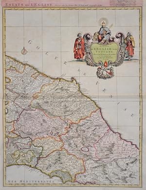
Estars de L' Eglise et de Toscane.
Edité par Artist: Mortier Peter ( - 1711 ) Amsterdam ; issued in: Amsterdam ; ca: 1700; - Pieter Mortier (1661?1711) was an 18th-century mapmaker and engraver from the Northern Netherlands Mortier had a partnership with Johannes Covens I (1697-1774) and founded the map publishing company Covens & Mortier (1721-1866) Mortier being French himself had easy access to French cartographers such as De L'Isle Sanson Jaillot de Fer and De Wit Consequently much of Mortier's business was built upon leveraging the sophisticated Dutch printing establishment to issue embellished high quality editions of previously contemporary French maps In the greater context of global cartography this was a significant advantage as most Dutch map publishes had at this point fal, 1661
Vendeur : Antique Sommer& Sapunaru KG, München, Allemagne
Membre d'association : ILAB VDA
Evaluation du vendeur :
Technic: Copper print; colorit: original colored; condition: Perfect condition, size (in cm): 60,5 x 45 cm; - Map shows central Italy, the east of Tuscany with the cities Urbino, Siena, Orvieto, Spoleto, Rome, etc. and a magnificent cartouche.; - Special feature: Royal edition, heightened with gold, rare.
-
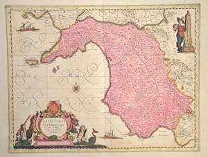
Principaute Citerieure
Edité par Artist: Mortier/ Blaeu W Peter ( - 1711 ) Amsterdam ; issued in: Amsterdam ; ca: 1660; - Pieter Mortier (1661?1711) was an 18th-century mapmaker and engraver from the Northern Netherlands Mortier had a partnership with Johannes Covens I (1697-1774) and founded the map publishing company Covens & Mortier (1721-1866) Mortier being French himself had easy access to French cartographers such as De L'Isle Sanson Jaillot de Fer and De Wit Consequently much of Mortier's business was built upon leveraging the sophisticated Dutch printing establishment to issue embellished high quality editions of previously contemporary French maps In the greater context of global cartography this was a significant advantage as most Dutch map publishes had at this, 1661
Vendeur : Antique Sommer& Sapunaru KG, München, Allemagne
Membre d'association : ILAB VDA
Evaluation du vendeur :
Technic: Copper print; colorit: original colored; condition: Some restoration at lower and upper centerfold, size (in cm): 38 x 49,5 cm; - Map shows Potenza in Campania with Naples, Salerno, Torre, Policastro Bussentino, Marsico Nuovo, Campagna, Muro Lucano and many more. Furthermore, two magnificent cartouches with coats of arms and mileage indicator, a compass rose and two sailing ships.; - Special feature: Royal edition, heightened with gold, rare.
-
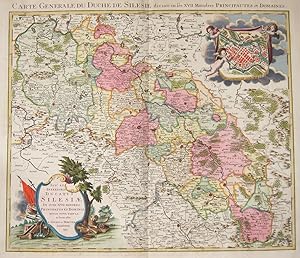
Seps et inferioris ducatus Silesiae / Carte Generale du Duche de Silesie
Edité par Artist: Mortier Peter ( - 1711 ) Amsterdam ; issued in: Amsterdam ; dated: 1741; - Pieter Mortier (1661?1711) was an 18th-century mapmaker and engraver from the Northern Netherlands Mortier had a partnership with Johannes Covens I (1697-1774) and founded the map publishing company Covens & Mortier (1721-1866) Mortier being French himself had easy access to French cartographers such as De L'Isle Sanson Jaillot de Fer and De Wit Consequently much of Mortier's business was built upon leveraging the sophisticated Dutch printing establishment to issue embellished high quality editions of previously contemporary French maps In the greater context of global cartography this was a significant advantage as most Dutch map publishes had at this point, 1661
Vendeur : Antique Sommer& Sapunaru KG, München, Allemagne
Membre d'association : ILAB VDA
Evaluation du vendeur :
Technic: Copper print; colorit: original colored; condition: Very good, printed on two sheets, joined together, size (in cm): 49 x 56,5; - Map depicts with 2 decorative cartouches complet Silesia.
-
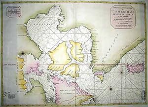
Carte particuliere de l'Amerique Septentrionale.
Edité par Artist: Mortier Peter ( - 1711 ) Amsterdam ; issued in: Amsterdam ; ca: 1710; - Pieter Mortier (1661?1711) was an 18th-century mapmaker and engraver from the Northern Netherlands Mortier had a partnership with Johannes Covens I (1697-1774) and founded the map publishing company Covens & Mortier (1721-1866) Mortier being French himself had easy access to French cartographers such as De L'Isle Sanson Jaillot de Fer and De Wit Consequently much of Mortier's business was built upon leveraging the sophisticated Dutch printing establishment to issue embellished high quality editions of previously contemporary French maps In the greater context of global cartography this was a significant advantage as most Dutch map publishes had at this point fal, 1661
Vendeur : Antique Sommer& Sapunaru KG, München, Allemagne
Membre d'association : ILAB VDA
Evaluation du vendeur :
Carte
Technic: Copper print; colorit: original colored; condition: Very good, size (in cm): 59,5 x 83; - chart of the northwestern Atlantic Ocean with Iceland, Greenland, and the Hudson Bay.
-
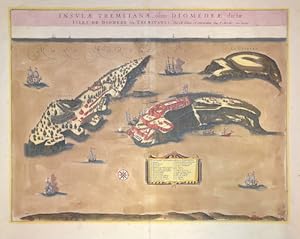
Insulae Tremitanae, olim Diomedeae dictae.
Edité par Artist: Mortier/ Blaeu W Peter ( - 1711 ) Amsterdam ; issued in: Amsterdam ; ca: 1724; - Pieter Mortier (1661?1711) was an 18th-century mapmaker and engraver from the Northern Netherlands Mortier had a partnership with Johannes Covens I (1697-1774) and founded the map publishing company Covens & Mortier (1721-1866) Mortier being French himself had easy access to French cartographers such as De L'Isle Sanson Jaillot de Fer and De Wit Consequently much of Mortier's business was built upon leveraging the sophisticated Dutch printing establishment to issue embellished high quality editions of previously contemporary French maps In the greater context of global cartography this was a significant advantage as most Dutch map publishes had at this, 1661
Vendeur : Antique Sommer& Sapunaru KG, München, Allemagne
Membre d'association : ILAB VDA
Evaluation du vendeur :
Technic: Copper print; colorit: original colored; condition: Break on the center because of oxidation, professional restored, size (in cm): 38 x 49,5 cm; - Map shows the Trimetic Islands in the Adriatic Sea off the coast of Italy, with many sailing ships, a compass rose and a cartouche with index. This map was originally created by Blaeu in 1662 and then reprinted by Mortier in 1724. The islands include San Domino, Capraia and San Nicola.
-
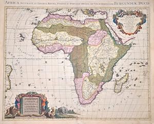
L'Afrique divisee en ses Empires, Royaumes, et Estats,
Edité par Artist: Mortier Peter ( - 1711 ) Amsterdam ; issued in: Amsterdam ; ca: 1694; - Pieter Mortier (1661?1711) was an 18th-century mapmaker and engraver from the Northern Netherlands Mortier had a partnership with Johannes Covens I (1697-1774) and founded the map publishing company Covens & Mortier (1721-1866) Mortier being French himself had easy access to French cartographers such as De L'Isle Sanson Jaillot de Fer and De Wit Consequently much of Mortier's business was built upon leveraging the sophisticated Dutch printing establishment to issue embellished high quality editions of previously contemporary French maps In the greater context of global cartography this was a significant advantage as most Dutch map publishes had at this point fal, 1661
Vendeur : Antique Sommer& Sapunaru KG, München, Allemagne
Membre d'association : ILAB VDA
Evaluation du vendeur :
Technic: Copper print; colorit: original colored; condition: Restoration at centerfold and missing part replaced, size (in cm): 57 x 88 cm; - Splendid old coloured map of the whole of Africa with Madagascar, a title cartouche and a mileage scale cartouche with inhabitants and animals of Africa. After Jaillot's map of 1674, which in turn is based on Sanson's map of 1668. Despite the title, this map was engraved by Pierre Mortier and published in Amsterdam.; - Special feature: Royal edition, heightened with gold.
-
Carte particuliere des Costes occidentales d Irlande.
Edité par Artist: Mortier Peter ( - 1711 ) Amsterdam ; issued in: Paris ; ca: 1740; - Pieter Mortier (1661?1711) was an 18th-century mapmaker and engraver from the Northern Netherlands Mortier had a partnership with Johannes Covens I (1697-1774) and founded the map publishing company Covens & Mortier (1721-1866) Mortier being French himself had easy access to French cartographers such as De L'Isle Sanson Jaillot de Fer and De Wit Consequently much of Mortier's business was built upon leveraging the sophisticated Dutch printing establishment to issue embellished high quality editions of previously contemporary French maps In the greater context of global cartography this was a significant advantage as most Dutch map publishes had at this point fallen, 1661
Vendeur : Antique Sommer& Sapunaru KG, München, Allemagne
Membre d'association : ILAB VDA
Evaluation du vendeur :
Technic: Copper print; colorit: original colored; condition: Very good, size (in cm): 60 x 86; - Map shows the coast of Irland from Galloway with Naught to Lymerick and Kerry, with inset map of Port Kinsal.
-
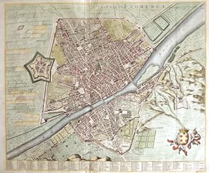
La ville de Florence
Edité par Artist: Mortier Peter ( - 1711 ) Amsterdam ; issued in: Amsterdam ; ca: 1690; - Pieter Mortier (1661?1711) was an 18th-century mapmaker and engraver from the Northern Netherlands Mortier had a partnership with Johannes Covens I (1697-1774) and founded the map publishing company Covens & Mortier (1721-1866) Mortier being French himself had easy access to French cartographers such as De L'Isle Sanson Jaillot de Fer and De Wit Consequently much of Mortier's business was built upon leveraging the sophisticated Dutch printing establishment to issue embellished high quality editions of previously contemporary French maps In the greater context of global cartography this was a significant advantage as most Dutch map publishes had at this point fal, 1661
Vendeur : Antique Sommer& Sapunaru KG, München, Allemagne
Membre d'association : ILAB VDA
Evaluation du vendeur :
Technic: Copper print; colorit: original colored; condition: Perfect condition, size (in cm): 51 x 60 cm; - Decorative and detailed city map of Florence in Tuscany, Italy.
-
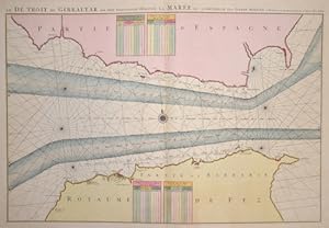
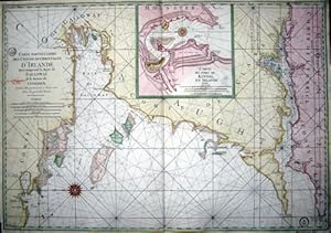
Le Detroit de Gibraltar ou sont exactement observee la Maree.
Edité par Artist: Mortier Peter ( - 1711 ) Amsterdam ; issued in: Amsterdam ; ca: 1695; - Pieter Mortier (1661?1711) was an 18th-century mapmaker and engraver from the Northern Netherlands Mortier had a partnership with Johannes Covens I (1697-1774) and founded the map publishing company Covens & Mortier (1721-1866) Mortier being French himself had easy access to French cartographers such as De L'Isle Sanson Jaillot de Fer and De Wit Consequently much of Mortier's business was built upon leveraging the sophisticated Dutch printing establishment to issue embellished high quality editions of previously contemporary French maps In the greater context of global cartography this was a significant advantage as most Dutch map publishes had at this point fal, 1661
Vendeur : Antique Sommer& Sapunaru KG, München, Allemagne
Membre d'association : ILAB VDA
Evaluation du vendeur :
Carte
Technic: Copper print; colorit: original colored; condition: Very good, size (in cm): 56 x 82; - Map shows the strait of Gibraltar with its sea current.
-
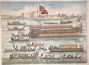
Solemnite du Bucentaure, qui se celebre a Venise le Jour de l'Ascension.
Edité par Artist: Mortier Peter ( - 1711 ) Amsterdam ; issued in: Amsterdam ; ca: 1695; - Pieter Mortier (1661?1711) was an 18th-century mapmaker and engraver from the Northern Netherlands Mortier had a partnership with Johannes Covens I (1697-1774) and founded the map publishing company Covens & Mortier (1721-1866) Mortier being French himself had easy access to French cartographers such as De L'Isle Sanson Jaillot de Fer and De Wit Consequently much of Mortier's business was built upon leveraging the sophisticated Dutch printing establishment to issue embellished high quality editions of previously contemporary French maps In the greater context of global cartography this was a significant advantage as most Dutch map publishes had at this point fal, 1661
Vendeur : Antique Sommer& Sapunaru KG, München, Allemagne
Membre d'association : ILAB VDA
Evaluation du vendeur :
Technic: Copper print; colorit: original colored; condition: Perfect condition, size (in cm): 29,5 x 40 cm; - The view shows Solemnite du Bucentaure, which is celebrated in Venice on the day of the Ascension. From: Histoire du gouvernement de Venise, avec des notes historiques et politiques par le sieur Amelot de la Houssaie. Tome. 1. Pag. 266. It shows a procession of ships, centred on the Doge's barge, the Bucentaur, passing by the church of San Nicolas de Lido to celebrate the annual ceremony of the "Marriage of the Sea". This ritual, which took place every year on Ascension Day from the Middle Ages until 1789, represented a symbolic link between Venice and the Adriatic Sea and was an affirmation of Venetian naval power. At the end of the ritual, the Doge dropped a ring consecrated by the Pope into the water. The large rowing boat "Bucintoro", here displays the Venetian flag with the Doge and church representatives on a platform at the stern. The other boats include gondolas of various sizes carrying dignitaries, each inscribed with their name, e.g. the gondola of the French ambassador and the gondola of the papal nuncio. Engraver Caspar Luyken, editor Peter Mortier. A version of this card was later reprinted by the successor company Covens and Mortier after Pierre Mortier's death.
