Montant total (1 article articles) :
Destination de la commande :

king of wales (10 résultats)
Passer aux résultats principaux de la recherche
Type d'article
- Tous les types d'articles
- Livres (7)
- Magazines & Périodiques
- Bandes dessinées
- Partitions de musique
- Art, Affiches et Gravures
- Photographies
- Cartes (3)
-
Manuscrits &
Papiers anciens
Etat
- Tous
- Neuf
- Ancien ou d'occasion
Reliure
Particularités
- Edition originale (2)
- Signé
- Jaquette
- Avec images (5)
- Sans impression ŕ la demande
Pays
Evaluation du vendeur
-

Trade Paperback. Etat : Very Good. 2nd Edition.
-

The Goblin
Edité par King of Wales, 1996
ISBN 10 : 9619127153ISBN 13 : 9789619127155
Vendeur : The Book Bin, Salem, OR, Etats-Unis
Membre d'association : ABAA CBA ILAB
Evaluation du vendeur :

Livre
Etat : Very Good. > PAPERBACK 1996. Covers show light scuffing and rubbing throughout with slight bumping to the edges and corners. Spine is sturdy. Binding is tight. Pages are bright, clean and free of marks.
-
Seven American Incunables Printed Before 1600.
Edité par LONDON: Maggs Bros Booksellers to His Majesty King George V and H.R.H. The Prince of Wales. Printed at Curwen Press, Plaistow. 1931., 1931
Vendeur : Paul Orssich HISPANIC STUDIES, LONDON, Royaume-Uni
Evaluation du vendeur :

4to. Rústica; cubiertas originales de papeles de aguas con solapas; etiqueta con título en negro en tapa superior.Una hoja blanca; 17 pp; 3 hojas blancas; facsímiles entre texto.Describe 6 obras impresas en México (incluyen los primeros tres libros impresos allí) y una en Lima: I. Juan Zumarraga: Doctrina Breve. MEXICO 1543. II. Jean Charlier de Gerson: Tripartito de Doctrina Christiana. MEXICO 1544. III. Rickel de Dionysius de Leuwis: Compendio Breve. MEXICO 1544. IV. Alphonez Gutierrez: Speculum Conjugiorum. MEXICO 1556. V. Alonso de Molina: Arte de la Lengua Mexicana. MEXICO 1571. VI. Alonso de Molina: Vocabulario en Lengua Castellana y Mexicana. MEXICO 1571. VII. Pedro de Ońa: Primera Parte de Arauco Domado. LIMA: 1596. Catalogue of Maggs Catalogues (p.52) Special Catalogues 14.
-
Baby's Book.
Edité par Raphael Tuck & Sons, Ltd, Publishers to Their Majesties the King and Queen & T. R. H. The Price and Princess of Wales [ - 1910 Whitton]; blue cloth with title on daisy design and baby suspended in a blanket and "illustrated by Frances Brundage" all in gilt, rounded spine with no lettering; gilt all around, plain endpapers, heavy coated paper, four one sided chromolitho plates, including frontis, and many drawings around the blanks to be filled in; 7.5x10; np, London, Paris, Berlin, Montreal, 1907
Vendeur : Truman Price & Suzanne Price / oldchildrensbooks, Monmouth, OR, Etats-Unis
Evaluation du vendeur :
/Frances Brundage, illustrator. (illustrateur). CONDITION: Very Good; no names or any writing at all, hinge paper partially cracked and neatly repaired, very tight and straight, a couple of tiny spots on back (1/32"), a lovely piece. Picture Book Hardback An unused turn of the century baby book, nothing filled in. Very bright and cheerful Edwardian babies, with poems and quotations from George Macdonald, Tennyson, and others and a poem celebrating each landmark event in the baby's life by the author. An elegant presentation. Pictured in Darrell Heppner's Great Children's Illustrators. ABE Heritage Seller since 1996; conservative AB condition grading. We ship all our books in cardboard protection. International shipping. /Frances Brundage, illustrator.
-
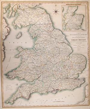
A Map of England, Wales + Scotland, describing all the Direct and principal Cross Roads in Great Britain, with the Distances measured between the.
Edité par Artist: Faden William ( - 1836 ) London ; issued in: Wales ; dated: 1801; - William Faden (1749 ? 1836) was an English cartographer and a publisher of maps He was the royal geographer to King George III He replaced Thomas Jeffreys in that roleThe title of -geographer to the king- was given to various people in the 18th century including John Senex Herman Moll Emmanuel Bowen and Thomas Jeffreys All of these men including William Faden were engravers and publishers not scholars or academics Their part was to publish and supply maps to the crown and parliament William Faden printed the North American Atlas in 1777 and "it became the most important atlas chronicling the Revolution's battles" There were 29 maps in the atlas and they included det, 1749
Vendeur : Antique Sommer& Sapunaru KG, München, Allemagne
Membre d'association : ILAB VDA
Evaluation du vendeur :

Technic: Steel engraving; colorit: original colored; condition: Perfect condition, size (in cm): 71,5 x 60; - Map depicts Englan, Wales and Scottland with all the mainstreets and major cities. With a decorativie wind rose and on an inset map Scottland.
-
MODERN PATRIOTISM, A POEM
Edité par London: printed for J. Brindley bookseller at the King's-Arms in New-Bond-Street book-binder to her Majesty and his Royal Highnbess the Prince of Wales and sold by J. Roberts in Warwick-Lane; J. Wilford behind the Chapter-House; Mrs. Nutt Cooke and Charlton at the Royal Exchange; A. Dodd at Temple-Bar; J. Crichley at Charing-Cross; and by the booksellers of London and Westminster, 1734
Vendeur : Christopher Edwards ABA ILAB, Henley-on-Thames, OXON, Royaume-Uni
Membre d'association : ABA ILAB
Evaluation du vendeur :
Edition originale
4to, pp. 54, [1] errata; pale waterstain in the lower portion, otherwise a very good copy; disbound. First edition of a very rare satire on the band of journalists and pamphleteers who made a profession of assailing the government of Sir Robert Walpole. Particularly conspicuous is the most successful of these, Nicholas Amhurst, who published the Craftsman under the pseudonym Caleb D'Anvers. Much abuse is directed against Papists and Jacobites; there is also a passage on Alexander Pope ('Dan Pope'). Complete with a final leaf of errata ('these sheets were hurried thro' the press in three or four days'). Foxon M377, locating five copies (BL, Huntington, Yale, Newberry and Kansas); ESTC adds no more. There is also a re-issue with a cancel title, given a subtitle or Faction display'd being a satire on political writers, but that is rarer still (three copies known).
-
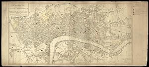
A New Pocket Plan of the Cities of London and Westminster: with the borough of Southwark: Comprehending the New Buildings and Alterations to the Year 1803.
Edité par Published by W. Faden, Geographer to the King and to the Prince of Wales, Charing Cross,, London,, 1803
Vendeur : Daniel Crouch Rare Books Ltd, London, Royaume-Uni
Membre d'association : ABA ILAB PBFA
Evaluation du vendeur :

Carte
Plan of London showing troop dispositions Engraved plan on two sheets, original outline hand-colour, manuscript annotations to map with manuscript key to right margin, a few old tears skilfully repaired and old folds reinforced. The plan gives information on parishes, in Westminster, Surrey, and Middlesex, with the Bills of Mortality. A coloured key shows the limits of the City of London, the intended buildings or new streets not finished, the Liberties of Westminster, and Rules of the Bench and Fleet. The border is divided into miles and furlongs based on St Paul's, and intended and unfinished development includes the area east of the Edgware Road and south of Euston Road; a circus at the east end of the Strand; and the London Docks. However, the most important feature of this map is the additional coloured key in a manuscript note to the right hand margin. This shows the disposition of troops, regular and volunteer, in various parts of London. Pencilled numbers appear against many of the sites but what these denote is unclear. Scale 6 1/4 inches to 1 statute mile. Howgego 186 (8).
-
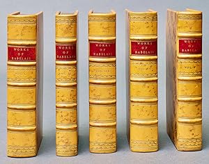
The works of Francis Rabelais, M.D. Now carefully revised, and compared throughout with the late new edition of M. Le du Chat, By Mr. Ozell. Who has likewise added at the bottom of the pages, a translation of the notes, historical, critical, and explanatory, of the said M. du Chat, and others: in which notes, never before printed in English, the text is not only explained, but, in multitudes of places, amended, and made conformable to the first and best Editions of this learned and facetious author. Adorn'd with 15 very neat copper-plates
Edité par printed by J. Hughs, near Lincoln's-Inn-Fields, for J. Brindley, bookseller to his Royal Highness the Prince of Wales, at the King's-Arms in New-Bond-Street; and C. Corbett, at Addison's Head, against St. Dunstan's Church, Fleet-street, London, 1737
Vendeur : Fine Editions Ltd, Lancaster, PA, Etats-Unis
Membre d'association : IOBA
Evaluation du vendeur :
Edition originale
Full Calf. Etat : Fine. First Edition thus. A gorgeous set of the first complete, scholarly edition in English, with explanatory notes, in five volumes, of this burlesque romance. 12mo: iii-xxii,iii-viii,cxxxiv,135-384; iii-x,11-251,[1]; xx,367[2 misnumbered 22],[5]; iii-xc,281,[13, including two final advertisement leaves]; lxiv,267,[5]pp, with 15 copper-engraved plates (11 of which are folding, one of which is a map), most bearing the signatures of Henry Roberts and Nathaniel Parr; numerous head- and tail-pieces and a woodcut in the text. Beautifully bound by Fitterer in period-style butterscotch cat's-paw calf, spines in six compartments between raised bands ruled in gilt, red morocco lettering pieces gilt, all edges gilt, marbled end papers, title pages (all five of which are cancels) printed in red and black. Lowndes 2033. ESTC Citation No. T13265. The first complete edition of Rabelais's works was published in Lyons, in 1567, by Jean Martin. Sir Thomas Urquhart's English translation of the first two books ("The finest translation ever made from one language into another," according to Charles Whibley) appeared in 1653, followed by Peter Anthony Motteux translation of the remaining three volumes and his revisions of Urquhart's first two in 1693 and 1694. Forty-three years later, in 1737, John Ozell revised (including restoring passages from Urquhart omitted by Motteux) and published our edition, combining the monumental translations of Sir Thomas Urquhart' wth those of Motteux and adding explanatory notes, in an edition that became the standard of the eighteenth and nmineteenth centuries. "For Rabelaisâ "monk, physician, humanistâ "nothing succeeds like excess. His giant heroes and their hard-living cronies wallow in the socially, aesthetically and politically incorrect. They're sexist, gluttonous, profane, bellicose, cruel, childish, ingenious, disputatious and completely vulgar. You wouldn't want them for neighbors, but they'd be great on your side in a fight." (Michael Dirda, Wash. Post, 2/16/1992) "Principally the story of two giants, a father (Gargantua) and his son (Pantagruel), and their adventures, presented as a connected series of five novels written in an extravagant, satirical vein featuring much crudity, scatological humor, and violence (the censors of the Sorbonne stigmatized the novels as obscene). While the first two books focus on the lives of the giants, the rest of the series is mostly devoted to the adventures of Pantagruel's friends, including Panurge, a roguish erudite maverick, and Brother Jean, a bold, voracious and boozing ex-monk, and others on a collective naval journey in search of the Divine Bottle. N. B. With few exceptions (always identified), we only stock books in exceptional condition. All orders are packaged with care and posted promptly. Satisfaction guaranteed. (Fine Editions Ltd is a member of the Independent Online Booksellers Association, and we subscribe to its codes of ethics.).
-
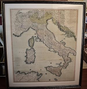
(Composite of) Italy with the addition of the southern parts of Germany as far as Pettau in Stiria; Murlakia, Dalmatia, the adjacent countries, and all the Illyric Islands (Extremely Large Map)
Edité par Published by Willm. Faden, Geographer to the King and to H.R.H. the Prince of Wales, Charing Cross, September 12th, 1816; Delarochette, 1816
Vendeur : Sequitur Books, Boonsboro, MD, Etats-Unis
Membre d'association : IOBA
Evaluation du vendeur :
Carte
Maps. Etat : Very Good. Third Edition with New Revisions. Very large and attractive hand-colored map of Italy. The various Italian states are listings. Also includes Corsica, Sardinia, Sicily, Malta, Slovenia, Croatia, Dalmatia, Southern Germany, Austria, Switzerland, Northern Africa, etc. The map shows roads, towns, rivers, lakes, islands, ports, harbors and major topographical features. Dimensions in frame: 153 x 137.5 cm. (60 1/4 x 54 1/4 inches). Dimensions of the map: 128 x 112 cm. 7 x 5 sections, laid on linen. Initially printed in two sections. Refs: Phillips 6010, 6013, 6047. David Rumsey, 2104.028 (citing 2nd edition). From William Faden's General Atlas of 1816. First published in 1800, this new map reflects the political changes after the Napoleonic conquest of Italy.
-
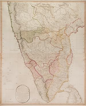
A Map of the Peninsular of India from the 19th degree north latitude to Cape Comorin.
Edité par London Printed for W. Faden Geographer to the King and to the Prince of Wales, 1800
Vendeur : Shapero Rare Books, London, Royaume-Uni
Membre d'association : ABA ILAB PBFA
Evaluation du vendeur :
Carte
Second edition; engraved map with hand colouring on two conjoined sheets (102 x 82 cm), framed and glazed, overall size: 111 by 93 cm by 2.5cm An interesting sectional map of southern India from the turn of the nineteenth century extending from Bombay in the North, to Cape Comorin in the South, and from Goa in the West to Narsapoor in the East, with hand-colour highlights showing the scope of British control in the region. Compiled from the 'papers communicated by the late Sir Arch[ibald] Campbell, the surveys of Col. Kelly, Capt. Pringle, Capt. Allan &c' (cartouche). The map was first published in 1792 following the successful conclusion of the Third Anglo-Mysore War and the Treaty of Seringapatam, which ceded over half of Tipu Sultan's lands to Britain and her princely-state allies. This the second edition, shows the outcome of the Fourth and final Anglo-Mysore War, which brought the kingdom's independence to an end in 1799. William Faden (1749-1836) served as geographer to George III and George IV. 'A gold-medalist of the (Royal) Society of Arts in 1796, he assembled an unrivalled stock of the large-scale maps of the British counties, and became a logical commercial partner for the Ordnance Survey Faden publishing the first published OS map in 1801. Some of his plates were later acquired by the Admiralty and re-issued as official Admiralty charts. He retired in 1823, the business passing to his former apprentice James Wyld' (BME).