
Montant total (1 article articles) :
Destination de la commande :

peninsular books (24 résultats)
Passer aux résultats principaux de la recherche
Type d'article
- Tous les types de produits
- Livres (23)
- Magazines & Périodiques
- Bandes dessinées
- Partitions de musique
- Art, Affiches et Gravures (1)
- Photographies
- Cartes
- Manuscrits & Papiers anciens
Etat
Reliure
- Toutes
- Couverture rigide (5)
- Couverture souple
Particularités
- Ed. originale
- Signé
- Jaquette
- Avec images (19)
- Sans impressions ŕ la demande (24)
Livraison gratuite
- Frais de port gratuits USA
Pays
Evaluation du vendeur
-

The Florida Handbook, 2001-2002 (Florida Handbook, 28th Ed) ; 9780961600082 ; 096160008X
Edité par Peninsular Books, 2001
ISBN 10 : 096160008XISBN 13 : 9780961600082
Livre
Etat : Very Good. Limited Copies Available - Very Good Condition - May have school stamp and/or student names - May have some cover wear - DOES NOT INCLUDE ANY CDs OR ACCESS CODES IF APPLICABLE.
-

The Florida Handbook, 1999-2000 (Florida Handbook)
Edité par Peninsular Books, 1999
ISBN 10 : 0961600071ISBN 13 : 9780961600075
Livre
Etat : Good. Item in good condition. Textbooks may not include supplemental items i.e. CDs, access codes etc.
Plus de choix d'achat de la part d'autres vendeurs sur AbeBooks
Offres d'occasion ŕ partir de EUR 10,69
Trouvez également Couverture rigide
-

The Florida Handbook 1995-96
Edité par Peninsular Books, 1995
ISBN 10 : 0961600055ISBN 13 : 9780961600051
Livre
hardcover. Etat : Very Good. Connecting readers with great books since 1972! Used books may not include companion materials, and may have some shelf wear or limited writing. We ship orders daily and Customer Service is our top priority!.
-

The Florida Handbook 1997-1998 (26th ed)
Edité par Peninsular Books, 1997
ISBN 10 : 0961600063ISBN 13 : 9780961600068
Vendeur : Wonder Book, Frederick, MD, Etats-Unis
Membre d'association : ABAA ILAB
Evaluation du vendeur :

Livre
Etat : Good. Good condition. Author: Morris. 26th biennial edition. (History, florida history, Florida government) A copy that has been read but remains intact. May contain markings such as bookplates, stamps, limited notes and highlighting, or a few light stains.
-
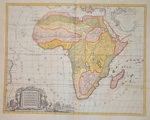
L'Afrique Divisee en ses Empires, Royaumes, et Etats Dressees
Edité par Artist: Elwe Jan Barend ( - 1777 ) Amsterdam ; issued in: Amsterdam ; ca: 1792; - Jan Barend Elwe ( 177 - 1815) was a Dutch publisher and book seller who reissued maps by De L Isle and Ottens and some other cartographers in the late 18th century His famous map "Amerique Septentrionale Divisee en ses Principales Parties" was derived mainly from Sanson?s and Jaillot?s maps of 1656 and 1676 At this time California was no longer shown as an island but as a peninsular and the Great Lakes to the north are enclosed which was another feature often shown incorrectly on earlier maps of America This map has been published in 1792 in an Atlas which included 37 other maps of different countries, 1777
Vendeur : Antique Sommer& Sapunaru KG, München, Allemagne
Membre d'association : ILAB VDA
Evaluation du vendeur :

Technic: Copper print; colorit: original colored; condition: top, left and right partly weak in print, size (in cm): 46 x 58,5 cm; - Map of the whole of Africa with splendid cartouche with inhabitants and animals of the continent. Upper title cartouche weak in print.
-
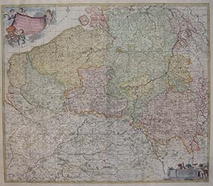
Carte nouvelle des Pais bas Catholiques
Edité par Artist: Elwe Jan Barend ( - 1777 ) Amsterdam ; issued in: Amsterdam ; dated: 1792; - Jan Barend Elwe ( 177 - 1815) was a Dutch publisher and book seller who reissued maps by De L Isle and Ottens and some other cartographers in the late 18th century His famous map "Amerique Septentrionale Divisee en ses Principales Parties" was derived mainly from Sanson?s and Jaillot?s maps of 1656 and 1676 At this time California was no longer shown as an island but as a peninsular and the Great Lakes to the north are enclosed which was another feature often shown incorrectly on earlier maps of America This map has been published in 1792 in an Atlas which included 37 other maps of different countries, 1777
Vendeur : Antique Sommer& Sapunaru KG, München, Allemagne
Membre d'association : ILAB VDA
Evaluation du vendeur :
Technic: Copper print; colorit: original colored; condition: Very good, size (in cm): 52 x 60; - Map shows total Belgium.
-
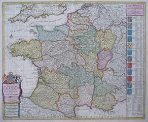
Carte nouvelle du Royaume de France divisé en toutes ses Provinces et ses acquisitions
Edité par Artist: Elwe Jan Barend ( - 1777 ) Amsterdam ; issued in: Amsterdam ; dated: 1792; - Jan Barend Elwe ( 177 - 1815) was a Dutch publisher and book seller who reissued maps by De L Isle and Ottens and some other cartographers in the late 18th century His famous map "Amerique Septentrionale Divisee en ses Principales Parties" was derived mainly from Sanson?s and Jaillot?s maps of 1656 and 1676 At this time California was no longer shown as an island but as a peninsular and the Great Lakes to the north are enclosed which was another feature often shown incorrectly on earlier maps of America This map has been published in 1792 in an Atlas which included 37 other maps of different countries, 1777
Vendeur : Antique Sommer& Sapunaru KG, München, Allemagne
Membre d'association : ILAB VDA
Evaluation du vendeur :
Technic: Copper print; colorit: original colored; condition: Very good, size (in cm): 48 x 58; - Map shows total France with the south part of England, also shows 12 beautiful coat of arms.
-
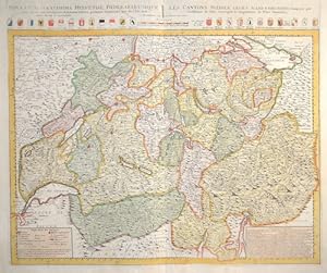
Nova et accuratissima Helvetiae, Foederaturumque. / Les Cantons Suisses, leurs Allies & Pays Sujets,.
Edité par Artist: Elwe Jan Barend ( - 1777 ) Amsterdam ; issued in: Amsterdam ; dated: 1792; - Jan Barend Elwe ( 177 - 1815) was a Dutch publisher and book seller who reissued maps by De L Isle and Ottens and some other cartographers in the late 18th century His famous map "Amerique Septentrionale Divisee en ses Principales Parties" was derived mainly from Sanson?s and Jaillot?s maps of 1656 and 1676 At this time California was no longer shown as an island but as a peninsular and the Great Lakes to the north are enclosed which was another feature often shown incorrectly on earlier maps of America This map has been published in 1792 in an Atlas which included 37 other maps of different countries, 1777
Vendeur : Antique Sommer& Sapunaru KG, München, Allemagne
Membre d'association : ILAB VDA
Evaluation du vendeur :
Technic: Copper print; colorit: original colored; condition: Perfect condition, size (in cm): 49,5 x 59,5; - Map depicts complete Swizzerland with all Kantons and their coat of arms.
-
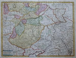
Partie meridionale de Moscovie, dressée par G. de L Isle .
Edité par Artist: Elwe Jan Barend ( - 1777 ) Amsterdam ; issued in: Amsterdam ; ca: 1792; - Jan Barend Elwe ( 177 - 1815) was a Dutch publisher and book seller who reissued maps by De L Isle and Ottens and some other cartographers in the late 18th century His famous map "Amerique Septentrionale Divisee en ses Principales Parties" was derived mainly from Sanson?s and Jaillot?s maps of 1656 and 1676 At this time California was no longer shown as an island but as a peninsular and the Great Lakes to the north are enclosed which was another feature often shown incorrectly on earlier maps of America This map has been published in 1792 in an Atlas which included 37 other maps of different countries, 1777
Vendeur : Antique Sommer& Sapunaru KG, München, Allemagne
Membre d'association : ILAB VDA
Evaluation du vendeur :
Technic: Copper print; colorit: original colored; condition: Very good, size (in cm): 41,5 x 55; - Map shows the city of Moscow and its surrounding.
-
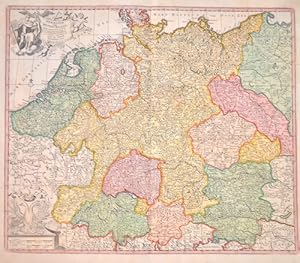
Germaniae Vulgo Duitschland,.
Edité par Artist: Elwe Jan Barend ( - 1777 ) Amsterdam ; issued in: Amsterdam ; dated: 1792; - Jan Barend Elwe ( 177 - 1815) was a Dutch publisher and book seller who reissued maps by De L Isle and Ottens and some other cartographers in the late 18th century His famous map "Amerique Septentrionale Divisee en ses Principales Parties" was derived mainly from Sanson?s and Jaillot?s maps of 1656 and 1676 At this time California was no longer shown as an island but as a peninsular and the Great Lakes to the north are enclosed which was another feature often shown incorrectly on earlier maps of America This map has been published in 1792 in an Atlas which included 37 other maps of different countries, 1777
Vendeur : Antique Sommer& Sapunaru KG, München, Allemagne
Membre d'association : ILAB VDA
Evaluation du vendeur :
Technic: Copper print; colorit: original colored; condition: Perfect condition, size (in cm): 49,5 x 58 cm; - Decorative map of Germany with Silesia, Bohemai, Netherlands, belgium, Elsass, Switzerland, Tyrol and Austria. With two cartouches, one with thegerman ; long necked double eagle;.
-
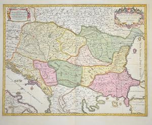
Le Royaume de Hongrie et les Estats qui ont esté Unis a sa Couronne
Edité par Artist: Elwe Jan Barend ( - 1777 ) Amsterdam ; issued in: Amsterdam ; dated: 1792; - Jan Barend Elwe ( 177 - 1815) was a Dutch publisher and book seller who reissued maps by De L Isle and Ottens and some other cartographers in the late 18th century His famous map "Amerique Septentrionale Divisee en ses Principales Parties" was derived mainly from Sanson?s and Jaillot?s maps of 1656 and 1676 At this time California was no longer shown as an island but as a peninsular and the Great Lakes to the north are enclosed which was another feature often shown incorrectly on earlier maps of America This map has been published in 1792 in an Atlas which included 37 other maps of different countries, 1777
Vendeur : Antique Sommer& Sapunaru KG, München, Allemagne
Membre d'association : ILAB VDA
Evaluation du vendeur :
Technic: Copper print; colorit: original colored; condition: Very good, size (in cm): 42,5 x 55; - Map shows total Dalmatia, Hungary, Moldavia, Romania, Bosnia, Serbia, partly Croatia, Turkey and two beautiful cartouches.
-
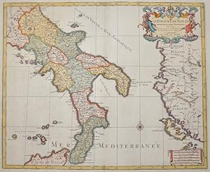
Le Royaume de Naples divisé en douze provinces.
Edité par Artist: Elwe Jan Barend ( - 1777 ) Amsterdam ; issued in: Amsterdam ; dated: 1792; - Jan Barend Elwe ( 177 - 1815) was a Dutch publisher and book seller who reissued maps by De L Isle and Ottens and some other cartographers in the late 18th century His famous map "Amerique Septentrionale Divisee en ses Principales Parties" was derived mainly from Sanson?s and Jaillot?s maps of 1656 and 1676 At this time California was no longer shown as an island but as a peninsular and the Great Lakes to the north are enclosed which was another feature often shown incorrectly on earlier maps of America This map has been published in 1792 in an Atlas which included 37 other maps of different countries, 1777
Vendeur : Antique Sommer& Sapunaru KG, München, Allemagne
Membre d'association : ILAB VDA
Evaluation du vendeur :
Technic: Copper print; colorit: original colored; condition: Very good, size (in cm): 43,5 x 53,5; - Map shows south Italy with its 12 provinces and partly Sicily and Greece with the island Corfu.
-
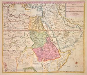
Carte de l Egypte de la Nubie de l Abissine
Edité par Artist: Elwe Jan Barend ( - 1777 ) Amsterdam ; issued in: Amsterdam ; dated: 1792; - Jan Barend Elwe ( 177 - 1815) was a Dutch publisher and book seller who reissued maps by De L Isle and Ottens and some other cartographers in the late 18th century His famous map "Amerique Septentrionale Divisee en ses Principales Parties" was derived mainly from Sanson?s and Jaillot?s maps of 1656 and 1676 At this time California was no longer shown as an island but as a peninsular and the Great Lakes to the north are enclosed which was another feature often shown incorrectly on earlier maps of America This map has been published in 1792 in an Atlas which included 37 other maps of different countries, 1777
Vendeur : Antique Sommer& Sapunaru KG, München, Allemagne
Membre d'association : ILAB VDA
Evaluation du vendeur :
Technic: Copper print; colorit: original colored; condition: Very good, size (in cm): 48,50 x 56,50; - Map shows Egypt, Nubia, Ethiopia and Arabia.
-
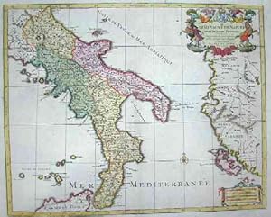
Le royaume de Naples divise en douze provinces
Edité par Artist: Elwe Jan Barend ( - 1777 ) Amsterdam ; issued in: Amsterdam ; dated: 1792; - Jan Barend Elwe ( 177 - 1815) was a Dutch publisher and book seller who reissued maps by De L Isle and Ottens and some other cartographers in the late 18th century His famous map "Amerique Septentrionale Divisee en ses Principales Parties" was derived mainly from Sanson?s and Jaillot?s maps of 1656 and 1676 At this time California was no longer shown as an island but as a peninsular and the Great Lakes to the north are enclosed which was another feature often shown incorrectly on earlier maps of America This map has been published in 1792 in an Atlas which included 37 other maps of different countries, 1777
Vendeur : Antique Sommer& Sapunaru KG, München, Allemagne
Membre d'association : ILAB VDA
Evaluation du vendeur :
Technic: Copper print; colorit: original colored; condition: Very good, size (in cm): 43,5 x 54; - Map shows south Italy with the Abruzzia, Campania, Apulia, Basilicata and Calabria, Corfu and the Leparic islands.
-
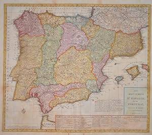
Les Royaumes d'Espagne et de Portugal
Edité par Artist: Elwe Jan Barend ( - 1777 ) Amsterdam ; issued in: Amsterdam ; ca: 1792; - Jan Barend Elwe ( 177 - 1815) was a Dutch publisher and book seller who reissued maps by De L Isle and Ottens and some other cartographers in the late 18th century His famous map "Amerique Septentrionale Divisee en ses Principales Parties" was derived mainly from Sanson?s and Jaillot?s maps of 1656 and 1676 At this time California was no longer shown as an island but as a peninsular and the Great Lakes to the north are enclosed which was another feature often shown incorrectly on earlier maps of America This map has been published in 1792 in an Atlas which included 37 other maps of different countries, 1777
Vendeur : Antique Sommer& Sapunaru KG, München, Allemagne
Membre d'association : ILAB VDA
Evaluation du vendeur :
Technic: Copper print; colorit: original colored; condition: Very good, size (in cm): 50 x 58 cm; - Map shows total Spain with Portugal and the Balearic island of Mallorca, Menorca and Ibiza with a decorative title cartouche. On the lower right pannel a description of the counties.
-

Atlas
Edité par Artist: Elwe Jan Barend ( - 1777 ) Amsterdam ; issued in: Amsterdam ; ca: 1792; - Jan Barend Elwe ( 177 - 1815) was a Dutch publisher and book seller who reissued maps by De L Isle and Ottens and some other cartographers in the late 18th century His famous map "Amerique Septentrionale Divisee en ses Principales Parties" was derived mainly from Sanson?s and Jaillot?s maps of 1656 and 1676 At this time California was no longer shown as an island but as a peninsular and the Great Lakes to the north are enclosed which was another feature often shown incorrectly on earlier maps of America This map has been published in 1792 in an Atlas which included 37 other maps of different countries, 1777
Vendeur : Antique Sommer& Sapunaru KG, München, Allemagne
Membre d'association : ILAB VDA
Evaluation du vendeur :
Art / Affiche / Gravure
Technic: Copper print; colorit: original colored; condition: Very good, size (in cm): 45,5 x 28,5; - Titlepage from the world Atlas of J.B. Elwe issued in Amsterdam 1792.
-
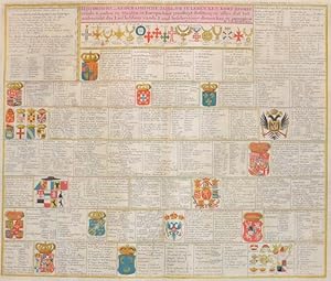
Historische en Geographische, Tafel. Om te leren een kort begrip vande Landen en Staaten in Europa. Haar grootheyt Besitting en alles at tot.
Edité par Artist: Elwe Jan Barend ( - 1777 ) Amsterdam ; issued in: Amsterdam ; dated: 1792; - Jan Barend Elwe ( 177 - 1815) was a Dutch publisher and book seller who reissued maps by De L Isle and Ottens and some other cartographers in the late 18th century His famous map "Amerique Septentrionale Divisee en ses Principales Parties" was derived mainly from Sanson?s and Jaillot?s maps of 1656 and 1676 At this time California was no longer shown as an island but as a peninsular and the Great Lakes to the north are enclosed which was another feature often shown incorrectly on earlier maps of America This map has been published in 1792 in an Atlas which included 37 other maps of different countries, 1777
Vendeur : Antique Sommer& Sapunaru KG, München, Allemagne
Membre d'association : ILAB VDA
Evaluation du vendeur :
Technic: Copper print; colorit: original colored; condition: Perfect condition, size (in cm): 49 x 57; - Map depicts the coat of arms of countries, kingdoms and citie of Europe. Very decorative with description of all the important emperors of the time.
-
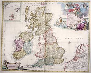
Les Isles Britanniques qui contiennent les Royaumes d Angleterre, Escosse, et Irlande.
Edité par Artist: Elwe Jan Barend ( - 1777 ) Amsterdam ; issued in: Amsterdam ; dated: 1792; - Jan Barend Elwe ( 177 - 1815) was a Dutch publisher and book seller who reissued maps by De L Isle and Ottens and some other cartographers in the late 18th century His famous map "Amerique Septentrionale Divisee en ses Principales Parties" was derived mainly from Sanson?s and Jaillot?s maps of 1656 and 1676 At this time California was no longer shown as an island but as a peninsular and the Great Lakes to the north are enclosed which was another feature often shown incorrectly on earlier maps of America This map has been published in 1792 in an Atlas which included 37 other maps of different countries, 1777
Vendeur : Antique Sommer& Sapunaru KG, München, Allemagne
Membre d'association : ILAB VDA
Evaluation du vendeur :
Technic: Copper print; colorit: original colored; condition: Very good, size (in cm): 47 x 59; - Map shows total Great Britain, inset map shows Orkney and Shettland Islands,; - Special feature: Map with 2 beautiful cartouches.
-
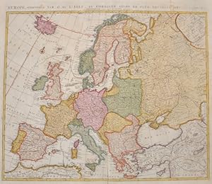
Europe, composée par G. d Isle et corrigée selon le plus nouvelle observations
Edité par Artist: Elwe Jan Barend ( - 1777 ) Amsterdam ; issued in: Amsterdam ; dated: 1792; - Jan Barend Elwe ( 177 - 1815) was a Dutch publisher and book seller who reissued maps by De L Isle and Ottens and some other cartographers in the late 18th century His famous map "Amerique Septentrionale Divisee en ses Principales Parties" was derived mainly from Sanson?s and Jaillot?s maps of 1656 and 1676 At this time California was no longer shown as an island but as a peninsular and the Great Lakes to the north are enclosed which was another feature often shown incorrectly on earlier maps of America This map has been published in 1792 in an Atlas which included 37 other maps of different countries, 1777
Vendeur : Antique Sommer& Sapunaru KG, München, Allemagne
Membre d'association : ILAB VDA
Evaluation du vendeur :
Technic: Copper print; colorit: original colored; condition: Very good, size (in cm): 50 x 58,5; - Map shows total Europe with Island.
-
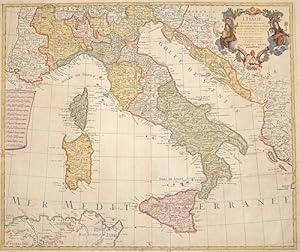
L Italie dressée sur les Observations.
Edité par Artist: Elwe Jan Barend ( - 1777 ) Amsterdam ; issued in: Amsterdam ; dated: 1792; - Jan Barend Elwe ( 177 - 1815) was a Dutch publisher and book seller who reissued maps by De L Isle and Ottens and some other cartographers in the late 18th century His famous map "Amerique Septentrionale Divisee en ses Principales Parties" was derived mainly from Sanson?s and Jaillot?s maps of 1656 and 1676 At this time California was no longer shown as an island but as a peninsular and the Great Lakes to the north are enclosed which was another feature often shown incorrectly on earlier maps of America This map has been published in 1792 in an Atlas which included 37 other maps of different countries, 1777
Vendeur : Antique Sommer& Sapunaru KG, München, Allemagne
Membre d'association : ILAB VDA
Evaluation du vendeur :
Technic: Copper print; colorit: original colored; condition: Perfect condition, size (in cm): 46 x 54,5 cm; - Map shows the whole of Italy with Corsica, Sardinia, Sicily, partly Croatia, Dalmatia and a title cartouche.
-

Nouvelle Carte de la petite Tartarie ou Turie , montrant les frontičres de l imperatrice de Russie.
Edité par Artist: Elwe Jan Barend ( - 1777 ) Amsterdam ; issued in: Amsterdam ; dated: 1792; - Jan Barend Elwe ( 177 - 1815) was a Dutch publisher and book seller who reissued maps by De L Isle and Ottens and some other cartographers in the late 18th century His famous map "Amerique Septentrionale Divisee en ses Principales Parties" was derived mainly from Sanson?s and Jaillot?s maps of 1656 and 1676 At this time California was no longer shown as an island but as a peninsular and the Great Lakes to the north are enclosed which was another feature often shown incorrectly on earlier maps of America This map has been published in 1792 in an Atlas which included 37 other maps of different countries, 1777
Vendeur : Antique Sommer& Sapunaru KG, München, Allemagne
Membre d'association : ILAB VDA
Evaluation du vendeur :
Technic: Copper print; colorit: original colored; condition: Double fold due to the printing, size (in cm): 51 x 59; - Map shows the peninsula Krim, Ukraine and the Black Sea with contiguous regions.
-
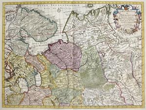
Carte Nouvelle de Moscovie Represente la partie Septentrionale.
Edité par Artist: Elwe Jan Barend ( - 1777 ) Amsterdam ; dated: 1792; - Jan Barend Elwe ( 177 - 1815) was a Dutch publisher and book seller who reissued maps by De L Isle and Ottens and some other cartographers in the late 18th century His famous map "Amerique Septentrionale Divisee en ses Principales Parties" was derived mainly from Sanson?s and Jaillot?s maps of 1656 and 1676 At this time California was no longer shown as an island but as a peninsular and the Great Lakes to the north are enclosed which was another feature often shown incorrectly on earlier maps of America This map has been published in 1792 in an Atlas which included 37 other maps of different countries, 1777
Vendeur : Antique Sommer& Sapunaru KG, München, Allemagne
Membre d'association : ILAB VDA
Evaluation du vendeur :
Technic: Copper print; colorit: original colored; condition: Very good, size (in cm): 41 x 54; - Map shows the northern part of european Russia with the distric Karelia and the peninsula Kola, Archangelsk, Jarensk to Wologia.
-
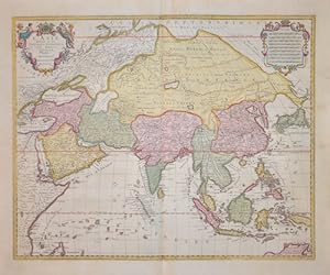
L' Asie
Edité par Artist: Elwe Jan Barend ( - 1777 ) Amsterdam ; issued in: Amsterdam ; dated: 1792; - Jan Barend Elwe ( 177 - 1815) was a Dutch publisher and book seller who reissued maps by De L Isle and Ottens and some other cartographers in the late 18th century His famous map "Amerique Septentrionale Divisee en ses Principales Parties" was derived mainly from Sanson?s and Jaillot?s maps of 1656 and 1676 At this time California was no longer shown as an island but as a peninsular and the Great Lakes to the north are enclosed which was another feature often shown incorrectly on earlier maps of America This map has been published in 1792 in an Atlas which included 37 other maps of different countries, 1777
Vendeur : Antique Sommer& Sapunaru KG, München, Allemagne
Membre d'association : ILAB VDA
Evaluation du vendeur :
Technic: Copper print; colorit: original colored; condition: Perfect condition, size (in cm): 46,5 x 58 cm; - Map shows total Asia, Southeast Asia, a magnificent title cartouche and a mileage indicator cartouche.