Montant total (1 article articles) :
Destination de la commande :

biographies (Plus de 4 400 résultats)
Passer aux résultats principaux de la recherche
Type d'article
- Tous les types d'articles
- Livres (3 770)
- Magazines & Périodiques (2)
- Bandes dessinées
- Partitions de musique (1)
- Art, Affiches et Gravures (617)
- Photographies (1)
- Cartes (19)
-
Manuscrits &
Papiers anciens (29)
Etat
Reliure
Particularités
- Edition originale (1 312)
- Signé (69)
- Jaquette (46)
- Avec images (2 942)
- Sans impression ŕ la demande (4 431)
Livraison gratuite
Pays
Evaluation du vendeur
-
An East Prospect of the City of Philadelphia: taken by George Heap from the Jersey Shore, under the Direction of Nicholas Skull [sic] Surveyor General of the Province of Pennsylvania
Edité par Engraved by G. Vandergucht, [London], 1754
Carte Edition originale
No binding. Etat : Near fine. First. "THE MOST DISTINGUISHED OF ALL PRINTS OF THE CITY OF PHILADELPHIA" [London:] Engraved by G. Vandergucht, Sep.br 1.st 1754. First state ("Skull" for "Scull" twice on sheet 3). Four sheets (ca. 29 1/2" x 23 1/2" each). Framed floating. An old transverse crease about 9" below the top edge, reinforced verso. Some small repairs to the sky. Tanning at the corners from an early mount. With good upper and lower margins throughout; sheets 1-3 trimmed to right-hand plate-mark; sheet 4 trimmed to left-hand plate-mark. Occasional very mild patches of tanning. An extraordinary set. From its founding in 1680 between the Delaware and Schuylkill Rivers, Philadelphia was strategically poised to be a hub of trade. By the mid-XVIIIc it had become the major Atlantic port, fueling a golden age of growth and eminence in the arts and sciences -- the Athens of America. The Penn family had long dominated the colony, and Thomas Penn, the founder's son, commissioned a grand view of the city in 1750 to commemorate and to enhance its stature (the Penn arms at the lower left corner of the third plate underscore their dominance). George Heap undertook the project; he had been Philadelphia's coroner. The ambition of the project matched the city's stature: it was the grandest illustrated view of an American city that had ever been attempted. Nicholas Scull (perhaps an uncle by marriage) superintended the work, and Heap began advertising for subscribers (20 shillings, 10 payable in advance) and with that money set sail for England (there being no means to print it in Philadelphia) with his drawings. Heap got only as far as Delaware, and died on-board; he was buried in Philadelphia on Boxing Day 1752. Thereafter Scull shepherded the vast work through the engraving and publishing process. The Dutch engraver Gerard Vandergucht was commissioned to cut the plates, which finally emerged in June of 1754 (the King hung it in his own apartments). Wainright begins his article on the prospect by hailing it as "the most distinguished of all prints of the city of Philadelphia in terms of age, rarity, and historic importance." In 1755 the view was shrunk by about two-thirds, and placed above a plan of the city and a view of the state house and the batter, engraved by Thomas Jefferys. This is far more common; of the Heap-Scull-Vandergucht view we have located only six copies in institutional collections: the American Philosophical Society (.748:P53:1754), Haverford College, Colonial Williamsburg, the Historical Society of Pennsylvania (second state), Independence National Historic Park and the New York Public Library (Stokes Collection, second state). Deák I:99 (second state). See Wainright, Nicholas B. "Scull and Heap's East Prospect of Philadelphia" in The Pennsylvania Magazine of History and Biography 73, no. 1 (January 1949) 16-25.
-
Figures of Plants
Edité par Thomas Martyn, 10 Great Marlborough Street, London, 1796
Vendeur : Donald A. Heald Rare Books (ABAA), New York, NY, Etats-Unis
Membre d'association : ABAA ILAB
Evaluation du vendeur :

3 volumes. Folio. (13 1/2 x 10 5/8 inches). 102 watercolors over etched line. 90 distinct watercolors with 12 variants. 1795 Volume: Unpaginated, 86 pp. Manuscript title page and 42 watercolors over etched line. 1796 Volume I: Unpaginated, 130 pp. Manuscript title and 30 watercolors over etched line, each with manuscript description on preceding leaf. 1796 Volume II: Unpaginated, 68 pp. 29 watercolors over etched lines with 3 ink manuscript leaves with descriptions. All finely bound in contemporary straight-grained red Morocco, 1795 Volume with gilt fillet, 1796 Volumes with gilt fillets and Greek key pattern borders on covers, all spines gilt in compartments, 1796 Volumes with drawer-handle motifs, all titled in gilt in second compartment [MARTYN'S PLANTS], 1795 Volume with marbled black and red endpapers, 1796 Volumes with marbled cobalt endpapers. 1795 Volume and 1796 Volume I with binder's ticket of Charles Hering (1763-1815) of 10 St. Martin Street in London on front pastedowns of each. An unparalleled collection of 102 magnificent watercolor botanical illustrations by Thomas Martyn and his academy. One of the rarest botanical books by a renown master; only four other examples in the census of copies. The Thomas Martyn (fl. 1760-1816) who produced Figures of Plants is not the Thomas Martyn (1735-1825) who wrote the commonly found Flora Rustica (1792) and was a professor of botany at Cambridge, like his father John Martyn (1699-1768). Our Martyn was born in Coventry, England. He was an artist and publisher of the natural sciences known best for the Universal Conchologist which illustrated exotic sea shells and won medals from many European leaders. His illustrations of plants, butterflies, shells, and spiders, remain among the most exquisite issued in book format. The plates of Martyn's books were lightly etched and watercolored by a group of young apprentice artists trained by Martyn for an operation he called the Academy for Painting Natural History. Martyn opened the academy in 1786 and by 1789 he employed 10 apprentices. Martyn recruited these youths because he desired a "uniformity and equality of style, conception, and execution which it would be in vain to expect from a variety of independent artists." Subsequent publications Martyn and his academy published include The English Entomologist (1792); Aranei or a Natural History of Spiders (1793); and Psyche: Figures of Nondescript Lepidopterous Insects (1797). The 1795 Volume has chain-laid endpapers with a "Lepard" watermark and wove paper with "J. Whatman" watermarks. The 1796 Volumes have "J. Whatman" watermarks on wove paper. The 1795 Volume is credited to "Mr. Martyn" at "No 10 Great Marlborough Street London" while the 1796 Volumes are credited to "Thomas Martyn" at "Great Marlborough Street London" with no street number. Each of the manuscript description leaves in the 1796 Volumes include the plant's common name, its Latin binomial, and a brief description as to its prevalence, habitat, size, and season. All of the drawings in 1796 Volume 1 have a leaf of manuscript description; only 3 in 1796 Volume II do. Figures of Plants Census: 1. British Library copy: 43 plates, no descriptions, 1795. Shelf number: 44.i.18 2. Newberry Library copy formerly owned by Henry Probasco: 2 folios, 65 plates, 1795-1796. 3. John Townley copy sold at Christie's October 19, Lot 28 in 1999: 2 volumes in 1, 65 plates, 1796. Sold at $157,965. 4. Fattorini copy sold at Sotheby's May 8, Lot 20 in 2002: 1 volume, 51 plates, 1795. Sold at $87,162. 5. Our copy: 3 volumes, 102 plates, many with descriptions, 1795-1796. Plate names: 1795 Volume: 42 distinct figures, hand-numbered in pencil with plate names. Unlike the 1796 volumes, these figures are depicted within gilt-rulings: 1. Sublinear Aster. 2. Heart Leaved Aster. 3. One Flowered Aster. 4. Indian Aster. 5. Umbrella Aster. 6. Pyrenean Aster. 7. Thready Flap. 8. Broad Leaved Pokeweed. 9. Short Rayed Aster. 10. Dolled Aster. 11. Curled Leaved Aster. 12. Canada Teucrine. 13. Teattering Aster. 14. Long Beaked Cranebill. 15. Caroline Sun Flower. 16. Hyssop Skullcap. 17. Oval Rockweed. 18. Wavy Leaved Aster. 19. Tuft Sword Leaf. 20. Common Willow Wart. 21. Long Spiked Aster. 22. Drooping Leaved Aster. 23. Pinnfield Bryong. 24. Blustery Aster. 25. Hairy Sleeps Rampion. 26. Expanded Hopwort. 27. Flaxy Aster. 28. Embroidered Cranebell. 29. Superb Tuft Flower. 30. Blue Sapifrage. 31. Arrow Broom. 32. Five Leaved Rattlewort. 33. Hoary Linwood. 34. Painted Cranebell. 35. Tall Bare Rocked. 36. American Hyssopine. 37. Entire Leaved Starry Scabious. 38. Alpine Downwort. 39. Ramping Leopard's Bane. 40. Helianthoide Ox Eye. 41. Hooked Mariot. 42. Pale Mullein. 1796 Volume I: 31 figures, 20 of which are distinct, 11 are variants. Hand-numbered in pencil with preceding ink manuscript name and description. 1. Sublinear Aster. 2. Pale Mullein. 3. Dingy Wellwood. 4. Coval Bears Sanicle. 5. Dark Loose Stripe. 6. Short Rayed Aster. 7. Heart Leaved Aster. 8. Broad Loose Stripe. 9. Indian Aster. 10. Hairy Aster. 11. Red-disk'd Aster. 12. Tufty Sword Leaf. 13 Heathy Aster. 14. Five Leaved Rattlewort. [Skips plate 15.] 16. Woody Tobacco. 17. Ramping Leopard's Bane. 18. Warted Thorn Apple. 19. Folded Sanicle. 20. Leafy Knight Weed. 21. Hyssop Skullcap. 22. Helianthoide Ox-Eye. 23. Fine Saned Pleuridge. 24. Violet Bell Flower. 25. Moors Teucrine. 26. Decumbent Mud-Weed. 27. Egg-Leaved Light Wort. 28. Stinging Tobacco. 29. Painted Cranebill. 30. Oriental Taperweed. 31. Azure Pink Weed. 32. Sea Scording. 1796 Volume II: 29 figures, 28 of which are distinct, 1 is a variant, with 3 ink manuscript title leaves and plates hand-numbered in pencil: 33. Long-Flowered Marvel of Peru. 50. Prickly Molucca Baum. 54. Water Mint. The rest of the figures are untitled. Boulger, Dictionary of National Biography, 1885-1900, Volume 36. Dall, "Thomas Martyn and the Universal Conchologist," Proceedings of the US National Museum, No. 1425, 1905, 415-432. Nichols, Li.
-
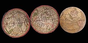
![Image du vendeur pour Globus Terrestris Novus [and] Globus Coelestis Novus Loca Terrae insigniora/sec. paraestant: Astron. Et Geogr./ observationes sistens,/ opera / Ioh. Gabr. Doppelmaieri / M.P.P, / concinne traditus / ŕ / loh. Georg: Puschnero / Chalcographo Norib./ A.C. 1730 [and] Loca stellarum fixarum / sec. cel. Ioh. Hevlium / ad anum 1730 exhibens / Opera / I.G. Doppelmaieri M.P.P. / exacte concinatus / a/ Ioh. Geor. Puschnero / Chalcographo Norib. A.C. 1730. mis en vente par Daniel Crouch Rare Books Ltd](https://pictures.abebooks.com/inventory/md/md30752771259.jpg)
Globus Terrestris Novus [and] Globus Coelestis Novus Loca Terrae insigniora/sec. paraestant: Astron. Et Geogr./ observationes sistens,/ opera / Ioh. Gabr. Doppelmaieri / M.P.P, / concinne traditus / ŕ / loh. Georg: Puschnero / Chalcographo Norib./ A.C. 1730 [and] Loca stellarum fixarum / sec. cel. Ioh. Hevlium / ad anum 1730 exhibens / Opera / I.G. Doppelmaieri M.P.P. / exacte concinatus / a/ Ioh. Geor. Puschnero / Chalcographo Norib. A.C. 1730.
Edité par Ioh. Georg. Puschnero,, 1730
Vendeur : Daniel Crouch Rare Books Ltd, London, Royaume-Uni
Membre d'association : ABA ILAB PBFA
Evaluation du vendeur :

Manuscrit / Papier ancien
No Binding. Etat : Fine. Popularising the new scientific ideas of the Enlightenment in Germany Terrestrial and celestial globes, each with 12 hand-coloured engraved paper gores, on a papier mâché and plaster sphere, graduated brass meridian ring, wooden octagonal horizon ring, supported on four turned ebonized columns united by cross- stretchers under the turned base, with four bun feet. Professionally restored, with small areas of infill, manuscript facsimile, uniformly toned, revarnished. Biography Johann Gabriel Doppelmayr (?1677-1750) was an astronomer and geographer who, from 1704 until his death, occupied the post of Professor of Mathematics at the Aegidien Gymnasium at Nuremberg. His activities as a globemaker formed part of his efforts to popularize the new scientific ideas of the Enlightenment in Germany. For that purpose, he translated several works into German, one of which was N. Bion's work on globes. He also produced several celestial maps, which were later included into his most famous work 'Atlas novus coelestia' of 1742, published by the house of Johann Baptist Homann. Between 1728 and 1736 Doppelmayr designed pairs of globes of several sizes - 100, 200 and 320mm (4, 8 and 12.5 inches) - in co-operation with the Nuremberg engraver Johann Georg Puschner I (1680-1749). Geography Doppelmayr's first globes of 1728 were 320mm (12.5 inches) in size, and the present example of 1730 are slightly smaller, measuring 200mm (8 inches) in diameter. The cartography follows Doppelmayr's 1728 globes with Spitzbergen drawn as an island, as it was known to be since De Rijp and Giles circumnavigated it in 1707. The river system is North America is represented based on the explorations of De la Salle, up to 1687, and California is drawn as a peninsula. Australia appears according to Tasman's discoveries, but Tasmania does not appear. There is a label for a hypothetical southern continent, reading "Terra Australis Incognita" without any contours shown. Dampier's exploration track is drawn and labelled "Navigatio Dampierie 1688". The globe, which is in Latin, includes scales for degrees, the zodiac, the Julian calendar, the Gregorian calendar and for 32 compass points. Astronomy The cartography is given in Latin, and the equator and ecliptic are both graduated and labelled. There is a magnitude table labelled "magnitudo stellarum", and the Milky Way is identified as "Via Lactea". The Magellanic Clouds are shown but not labelled. The globe depicts 48 Ptolemaic constellations, as well as the non-Ptolemaic constellations of Coma Berenices, Antinous, Crux and Columba. It also presents the 12 southern constellations of Plancius, and all of those of Hevelius. Dekker GLB0075 (terrestrial), GLB0076 (celestial); Van der Krogt Dop 4 (terrestrial), Dop 7 (celestial).
-
The Life of Samuel Johnson, Comprehending an Account of His Studies and Numerous Works, in Chronological Order The Whole Exhibiting a View of Literature and Literary Men in Great Britain for Near a Century During Which He Flourished. In Two Volumes.
Edité par London: by Henry Baldwin for Charles Dilly, 1791, 1791
Vendeur : Peter Harrington. ABA/ ILAB., London, Royaume-Uni
Membre d'association : ABA ILAB PBFA
Evaluation du vendeur :
Edition originale
First edition, first state (p. 135, vol. 1, uncorrected, reading "gve"), of the most famous biography in any language. The immense task of compiling the thousands of notes Boswell had recorded on "the great man's talk, habits and opinions" was begun after Johnson's death in 1784. Made up of trifling incidents as well as the significant events in Johnson's life, the work remains a masterpiece of portraiture. "The Life of Johnson was no single book miraculously produced by an inexperienced author. It was the crowning achievement of an artist who for more than twenty-five years had been deliberately disciplining himself for such a task" (Pottle, p. xxi). "Homer is not more decidedly the first of heroic poets, Shakespeare is not more decidedly the first of dramatists, Demosthenes is not more decidedly the first of orators, than Boswell is the first of biographers" (Macaulay). This copy has p. 135, vol. 1, in the uncorrected first state, reading "gve". Some copies were corrected in the press to "give", and 1,750 copies in either state were available on publication day, 16 May 1791 (800 were sold in the first two weeks). Courtney 172; Grolier, English 54; Rothschild 463; Pottle 79; Tinker 338. 2 volumes, quarto (approx. 295 x 230 mm). Uncut in original blue paper boards backed with buff paper, original printed spine labels. Housed in a black cloth folding case. Portrait frontispiece engraved by James Heath after Sir Joshua Reynolds, 2 engraved facsimile plates by H. Shepherd. Text printed on pale blue paper. Two prelims (pp. ix-xii) intended for vol. I misbound in vol. II immediately after the title leaf. Significant loss of paper to spines, the labels rubbed but largely intact, some stripping of paper sides exposing boards beneath, still a most desirable copy in unrestored original condition.
-
![Image du vendeur pour [A set of two globes and one armillary sphere] Globe terrestre sur le quel Les Principaux Points sont placez sur les dernieres Observations de Mrs de l'Academie Royale des Sciences Par M. Buy de Mornas Geographe du Roi et des Enfants de France, [and] Globe celeste, [and armillary]. mis en vente par Daniel Crouch Rare Books Ltd](https://pictures.abebooks.com/inventory/md/md30752771954.jpg)
[A set of two globes and one armillary sphere] Globe terrestre sur le quel Les Principaux Points sont placez sur les dernieres Observations de Mrs de l'Academie Royale des Sciences Par M. Buy de Mornas Geographe du Roi et des Enfants de France, [and] Globe celeste, [and armillary].
Edité par Chez le Sr. Fortin, Ingenieur, Mecanicien du Roy pour les Globes et Spheres, rue de la Harpe 1768 [celestial globe dated 1770, armillary dated 1773]., 1768
Vendeur : Daniel Crouch Rare Books Ltd, London, Royaume-Uni
Membre d'association : ABA ILAB PBFA
Evaluation du vendeur :
Manuscrit / Papier ancien
No Binding. Etat : Fine. Ingenieur-Mechanicien pour les Globes et Spheres A pair of terrestrial and celestial globes, each with 12 hand-coloured engraved paper gores over papier mâché and plaster sphere, varnished, paste-board meridian ring, wooden horizon ring, raised by four quadrant supports, mounted on an ebonized turned wood table stand. Together with an armillary sphere, containing globe with 12 hand-coloured engraved gores, over a papier mâché and plaster sphere, varnished wood, raised on four quadrant supports, with ebonised turned wood table stand. Biography Jean Fortin (1750-1831) was a scientific instrument-maker born in Picardy, France. Chiefly remembered for designing a barometer that ensured more accurate readings, he also produced celestial atlases, scales and was commissioned by the French royal family to make globes. He made terrestrial and celestial globes of 320 and 220mm (12 and 8.75 inches) diameter, as well as a terrestrial globe of 55mm (2.25 inches) to go into his armillary spheres. Fortin operated in Paris, with a shop in the Rue de la Harpe, where he referred to himself as "Ingenieur-Mecanicien pour les Globes et Spheres". He is also known for publishing the new celestial atlas of John Flamsteed (1646-1719) in 1762, which was highly influential as a source for celestial cartography throughout the rest of the century. His business was continued by his son Augustin, grandson Michel and great-grandson Augustin. Geography The prime meridian, which runs through the Canary Islands at Ferro, the equator, and the ecliptic are all graduated and labelled. The ecliptic includes the signs of the zodiac. Australia and New Zealand are drawn according to the discoveries of Abel Tasman; a dotted line marks a hypothetical northeast, east, and south coast of Australia. There are no tracks of voyages shown, but the lands seen by Quiros and David are marked. The two demi-meridian rings mark the latitude and longitude of the major cities of the world. North America extends almost to the north pole, and is apparently attached to Asia in the west and Greenland in the east. However, California is shown as a peninsula. Astronomy The equator is graduated and labelled "Cercle de L'Equateur" and "Cercle Equinoctial". The ecliptic is graduated; it is labelled "Ligne Eclipt" and "la Zodiaque" and provided with the symbols of the signs of the zodiac. There are labels for the "Artique" along the north polar circle "the Tropique de Capricorn", "the Tropique de Cander", "the Pol. d'eclipt. Australle", "the Colure des Aequinoxe" and "the Colure des Solstique". There is a magnitude table which is labelled "Gr. et Figure des Etoilles". The 48 Ptolemaic constellations are shown as well as the non-Ptolemaic constellations Antinous, La Chevelure de Berenice, La Croix, and La Colombe. The 12 southern constellations of Plancius are depicted. Armillary The Ptolemaic armillary sphere shows the cosmos with the earth at its centre. The complex device is made of moving circles: a meridian surmounted by an hour circle with metal pointer and an internal ring structure of polar circles, tropics and equator, joined by an equinoctial and a solstitial colure and surrounded by a planar zodiac band. These elements surround a rotating terrestrial globe with 12 gores and revolving sun and moon of flat paste-board discs, horizon band with calendar and zodiac. The four quadrant supporting the horizon ring give the latitude and longitude of major cities throughout the world.
-

Voyage De La Perouse Autour Du Monde, Publie Conformement Au Decret Du 22 Avril 1791, et Redige Par M. L. A. Milet-Mureau
Edité par Imprimerie De La Republique, Paris, 1797
Vendeur : Arader Galleries - AraderNYC, New York, NY, Etats-Unis
Evaluation du vendeur :
Edition originale
5 volumes: 4 text volumes, 4to., (11 7/8 x 8 6/8 inches); Atlas volume, folio (22 x 17 inches). Engraved frontispiece portrait of Galaup after Alex Tardieu in the first of the text volumes. Engraved title-page, fine large engraved double-page folding map of "Mappe Monde ou Carte Reduite du Parties commes de Globe pour servir a Voyage de la Perouse. 1785,86,87,88.", 30 maps, including 20 folding, and 36 of 38 views, plans, and plates depicting flora, fauna and boats (without half-title to the Atlas, and plates 11, the view of Easter Island, and 23 the plate of the costumes and inhabitants of Port des France on the North-West coast of America). Text volumes bound in contemporary tree calf, spines elaborately decorated in gilt, Atlas volume uniformly bound in half calf marbled paper boards (extremities of text volumes scuffed, Atlas volume extremities worn). First edition. The voyage of La Perouse is "one of the most important scientific explorations ever undertaken to the Pacific and the west coast of North America" In 1783 the French government resolved to send an expedition to the Pacific to complete Captain James Cook's "unfinished work, and in particular to explore the passages in the Bering Sea, which had been a mystery to Europeans since the sixteenth century. King Louis XVI himself took a hand in drafting the plan and itinerary, a copy of which is in the Municipal Library at Rouen, France, and when La Pérouse was selected to lead the fleet gave him an audience before he sailed. In command of two ships, La Boussole and L'Astrolabe (Commandant de Langle), he left Brest on 1 August 1785 making for Brazil. Doubling Cape Horn he refitted in Chile, then sailed to the Sandwich Islands and thence to Alaska, where he turned south exploring and surveying the coast as far as California. After a short refit at Monterey, he sailed across the Pacific, discovered uncharted islands, and visited Macao and Manila. After six weeks reprovisioning and refreshing he left on 10 April 1787 to survey the coasts and territories north of Korea, which had been described and commented on by Christian missionaries. He sailed up the Gulf of Tartary, naming several points on both its shores and learned that Sakhalin was an island. In September he put in to Kamchatka to replenish his supplies. From there he dispatched an officer, Lesseps, overland to Paris with accounts of his discoveries, while he turned south making for New Holland. In December, at Tutuila, Samoa, which Bougainville had called the Navigator Islands when he explored them in 1768, natives suddenly attacked a party from L'Astrolabe seeking water and killed de Langle and eleven others. La Pérouse left without taking reprisals and sailed through the Pacific Islands to Norfolk Island and to Botany Bay. He was sighted off the coast there on 24 January 1788 but bad weather prevented his entering the bay for two days. By then Governor Arthur Phillip had sailed to Port Jackson, but John Hunter had remained with the Sirius and the transports, and assisted La Pérouse to anchor. He established a camp on the northern shore, now called after him, and maintained good relations with the English during his six-week stay. He sailed on 10 March and was not heard of again. His disappearance led the French government in 1791 to equip another expedition under Bruny d'Entrecasteaux to look for him, but the search was fruitless" (Leslie R. Marchant for Australian Dictionary of National Biography online). The expedition and this atlas are especially regarded for superb mapping of the Alaskan and Californian coasts. Maps include San Diego, Monterey, and the whole of the Northwest coast. "It is one of the finest narratives of maritime exploration ever written, and certainly deserves to hold a place of high honor among the great travel accounts of the 18th century" (Howell). Ferguson 251; Hill 972; Lada-Mocarski 52; Sabin 38960; Smith 2109; Staton & Tremaine/TPL 596; Streeter sale VI:3493; Wickersham 6611; Zamo.
-
![Image du vendeur pour Globus Terrestris Novus [and] Globus Coelestis Novus. opera Ioh. Gab. Doppelmaireri M.P.P. exhibitus a Ioh Georg: Puschnero Chalcogr Norib A. 1736 [and] cura I.G. Doppelmaieri M.P.P. adoratus a I.G. Puschnero Calcogr Norib A.1736. mis en vente par Daniel Crouch Rare Books Ltd](https://pictures.abebooks.com/inventory/md/md30752771260.jpg)
Globus Terrestris Novus [and] Globus Coelestis Novus. opera Ioh. Gab. Doppelmaireri M.P.P. exhibitus a Ioh Georg: Puschnero Chalcogr Norib A. 1736 [and] cura I.G. Doppelmaieri M.P.P. adoratus a I.G. Puschnero Calcogr Norib A.1736.
Edité par I.G. Puschero, 1736; [celestial globe dated 1735]., 1736
Vendeur : Daniel Crouch Rare Books Ltd, London, Royaume-Uni
Membre d'association : ABA ILAB PBFA
Evaluation du vendeur :
Manuscrit / Papier ancien
No Binding. Etat : Fine. Doppelmayr's smallest globes Terrestrial and celestial globes, each with 12 hand-coloured engraved paper gores, over a papier mâché and plaster sphere, brass meridian ring, wooden octagonal horizon ring, supported on four turned bone columns united by cross-stretchers under the turned base, with four bun feet. Terrestrial globe gores occasionally worn with loss, recent infill to the coastline of eastern South America, celestial globe with very minor wear in two places. Biography Johann Gabriel Doppelmayr (?1677-1750) was an astronomer and geographer who, from 1704 until his death, occupied the post of Professor of Mathematics at the Aegidien Gymnasium at Nuremberg. His activities as a globemaker formed part of his efforts to popularize the new scientific ideas of the Enlightenment in Germany. For that purpose, he translated several works into German, one of which was N. Bion's work on globes. He also produced several celestial maps, which were later included into his most famous work 'Atlas novus coelestia' of 1742, published by the house of Johann Baptist Homann. Between 1728 and 1736 Doppelmayr designed pairs of globes of several sizes - 100, 200 and 320mm (4, 8 and 12.5 inches) - in co-operation with the Nuremberg engraver Johann Georg Puschner I (1680-1749). Geography The cartography on this globe is the same as Doppelmayr's 320mm (12.5 inches) globes of 1728 and 200mm (8 inches) globes of 1730, however there are no exploration tracks drawn. Astronomy The cartography is given in Latin, the equator and ecliptic are both graduated and labelled. The constellations are depicted as mythical beasts and figures and some scientific instruments. Below "Carter" (ie Crater) appears a magnitude table labelled "Magnit: Stell:". The Magellanic Clouds are shown but not labelled. The globe depicts 48 Ptolemaic constellations, as well as the non-Ptolemaic constellations of Coma Berenices, Antinous, Crux and Columba. It also presents the 12 southern constellations of Plancius, and all of those of Hevelius.
-
THE LIFE OF SAMUEL JOHNSON, LL.D. Comprehending an account of his studies and numerous works, in chronological order; a series of his epistolary correspondence and conversations with many eminent persons; and various original pieces of his composition never before published. The whole exhibiting a view of literature and literary men in Great-Britain, for near half a century, during which he flourished.
Edité par Printed by Henry Baldwin for Charles Dilly in the Poultry, 1791
Vendeur : Jonkers Rare Books, Henley on Thames, OXON, Royaume-Uni
Membre d'association : ABA ILAB PBFA
Evaluation du vendeur :
First edition. Two volumes, quarto (295mm x 225mm). Original publisher's blue-grey paper boards, manuscript titles to spine. Uncut. First issue, with "gve" on page 135 of the first volume. All seven cancels present as usual, though lacking the preliminary blank in the second volume. A fine copy of a work rarely encountered in an original state. The boards are worn at the corners, with some soiling to the covers and minor repairs to the joints. Internally the pages are unpressed and uncut. There is a repaired closed tear to the margin of the frontispiece, very minor marginal worming from Mm-Ccc. Housed in custom made fleece-lined chemise and cloth slipcase. Engraved frontispiece of the subject to volume I, engraved 'Round Robin' plate and facsimile of Johnson's handwriting to rear of volume II. The Life Of Johnson was published on 16th May 1791 priced at two guineas and issued in the blue-grey boards of the present copy. Though the first edition comprised 1,750 sets of sheets, copies in the original boards are uncommon and usually feature far more repair than in the present example. The work was an immediate commercial success, and paved the way for modern biography. Even Thomas Macauley, who published a now infamous review of a new edition of Boswell's Life Of Johnson in 1831 that did little for either Boswell's or Johnson's nineteenth century reputation, was forced to admit that "The Life of Johnson is assuredly a great, a very great work. Homer is not more decidedly the first of heroic poets, Shakspeare is not more decidedly the first of dramatists, Demosthenes is not more decidedly the first of orators, than Boswell is the first of biographers. He has no second. He has distanced all his competitors so decidedly that it is not worth while to place them." Pottle 79, Rothschild 463, Grolier English Literature.
-
THE WORKS OF MR. WILLIAM SHAKESPEAR IN SIX VOLUMES: ADORN'D WITH CUTS
Edité par Jacob Tonson & Edmund Curl, 1709
Livre Edition originale
Hardcover. Etat : Very Good. No Jacket. 1st Edition, Illustrated Edition. THE WORKS OF MR. WILLIAM SHAKESPEAR IN SIX VOLUMES: ADORN'D WITH CUTS was published in 1709 by Jacob Tonson & edited by Nicholas Rowe. They are the 1st edition of Shakespeare's plays published after the four folios. These are the first illustrated edition of Shakespeare's plays, 1st edition to indicate acts, scenes & dramatis personae, 1st to provide stage directions, 1st to include a formal biography of Shakespeare. Also includes THE WORKS OF MR. WILLIAM SHAKESPEAR. VOLUME THE SEVENTH. CONTAINING VENUS & ADONIS, TARQUIN & LUCRECE AND HIS MISCELLANY POEMS published in 1710 by Edmund Curll. "The significance of the 'volume the seventh' as has been generally understood, is in the fact that the book was intended as a supplementary volume to be sold to purchasers of the set of Rowe's Works of Shakespeare" (Alden, 1916). This octavo set is bound in full calf, with gilt & blind tooled covers, gilt tooled spines with five raised bands, gilt titles to spines. Frontispiece & plates present all volumes. The text block (19 cm) is laid paper. Endpapers are wove, indicating the set was bound after 1759. An owner's inscription on volume 5's title page reads "ex libris Georgii Trenthas(?) Talbot". The 14th Earl of Shrewsbury (George Talbot 1719-1787), lived about the same time these volumes were bound. The father of the Earl (George Talbot 1675-1733) died before these volumes were bound, given the use of wove paper. It seems likely that this set was owned by the 14th Earl. CONDITION - In all seven volumes there are no missing pages, no page tears, corners not bumped, hinges are sound, binding is tight. Calf on all boards in fine condition. Top & bottom edges of spines rubbed. Light toning throughout. No markings at all except as noted below in Vol 1 & 5. Vol 1: old bookseller's price in pencil on front pastedown & ink gift inscription on free front endpaper. Vol 2: occasional foxing. Vol 3: small scuff to spine, small stain pg. 1087, some foxing. Vol 4: 3/8" worming bottom of front hinge, Ľ" spots pp. 1561-1562, some foxing. Vol 5: title page has ink in old hand "ex libris Georgii Trenthas(?) Talbot" . Plate facing Hamlet Play Title page has been hand-colored. Small scuff to spine, Ľ" stain pp. 2182 & 2183, small ink stain on fore-edge of pp. 2383-2391 doesn't affect text, areas of foxing pg 2573 & 2641-2647. Vol 6: foxing on pp. 2661, 3771, 3185. Vol 7: worming like Vol 4, stain in dedication pages, some foxing. Overall a gorgeous set in very good condition. DISTINGUISHING POINTS: Vol.1-5 are first editions, conforming to ESTC T138294 for signatures, pagination & plates, and to Ford's "Shakespeare, 1700-1740" first issue criteria regarding collation & pagination errors. Vol. 6 conforms to ESTC T138297 & to Ford's Second Issue criteria. ESTC T138297 refers to this edition as a 'lineatim reprint (possibly surreptitious) of the ESTC T138294 edition of the same year'. However, UCLA Clark rare book library states "H.L. Ford in 'Shakespeare 1700-1740', Oxford, 1935, claims that there were 2 printings of Tonson's 1709 ed. However, a comparison of sets of this ed. with Ford's distinguishing points of the 2 printings reveals that each set is composed of sheets from both printings, and that in many cases individual vols. are also composed of sheets from both printings. Possibly the printings were not discrete." Vol. 7 (Poems) is described in ESTC T138298 as "Intended to accompany the 6v. Rowe edition of 1709." It conforms to ESTC T138298, which states: "Editor's dedication signed: S.N. The 'critical remarks' and 'An essay' are by Charles Gildon." Vol. 7 contains the same Dedication by Charles Gildon. According to Alden, "There has been considerable uncertainty as to the editor of the volume, some authorities referring it to Charles Gildon, known to be the author of the essays it contains, others to a mysterious 'S. N.,' because in some copies those initials are attached to the Dedication." SHIPMENT: free, via US Postal Service Registered mail only.
-
![Image du vendeur pour A Journal of a Voyage round the World in His Majesty's Ship Endeavor, in the Years 1768, 1769, 1770, and 1771. [-] To which is added a Concise Vocabulary of the Language of Otahitee. mis en vente par Peter Keisogloff Rare Books, Inc.](https://pictures.abebooks.com/inventory/md/md16199272640.jpg)
A Journal of a Voyage round the World in His Majesty's Ship Endeavor, in the Years 1768, 1769, 1770, and 1771. [-] To which is added a Concise Vocabulary of the Language of Otahitee.
Edité par London, Printed for T. Becket and P. A. De Hondt, in the Strand., 1771
Vendeur : Peter Keisogloff Rare Books, Inc., Brecksville, OH, Etats-Unis
Evaluation du vendeur :

Edition originale
Hardcover. Etat : Very Good. No Jacket. 1st Edition. First edition, second issue, without the dedication leaf. The first printed account of Cook's First Voyage, and discovery of the eastern coast of Australia. Quarto; size of the binding: 8 1/2 inches x 10 3/4 in., title-page; 130 pp. + [4] pp. (three are printed pages of the Vocabulary). Approx. page size: 8 1/4 in. x 10 5/8 in. Old diced calf sides and corner-pieces, with most of the leather now chipped from the spine (some of the gilt titling is present), and marbled paper over boards; early, inner cloth hinges. This copy bears the engraved heraldic bookplate of English novelist, Anthony Trollope (1815-82), printed on blue-gray paper and initialed in ink: R.B. [Rare Book?, possibly written by Trollope], and the bookplate of Cleveland, Ohio book collector, William G. Mather (1857-1951) and two mounted early catalogue entries, and a mounted, typed letter from Cleveland, Ohio based booksellers, Burrows Brothers, describing this copy. The early binding shows wear to the spine, cover corners & edges, and to the marbled paper, small ink stains, spots to the title-page. A rare book. From the Burrows Brothers letter to another book collector: "Oct. 28, 1915. With a lot of books recently received from a library of a Massachusetts Collector, is an exceedingly valuable book, probably as scarce as we have ever had. It is a copy of the rare first edition of Cook's 'Journal of a Voyage Round the World.' London, 1771. This edition is apparently almost unknown. The only other copies we find any record of being one in the Bodleian Library, and the other described in one of Magg's Lists some time ago, clipping from the latter being mounted in this volume. We feel sure that our copy is as fine and prefect as they catalogue, and in addition it has an extra value, as it carries the Book Plate of Anthony Trollope. We would like to have you see this volume as we think you would like to become its owner. We have looked through all our sales and auction records, biographies and bibliographies, and find no notice of this book, or that a copy has ever been offered for sale, except as above. This Journal was published anonymously, and it is the first publication containing the Narrative of Cook's First Voyage. It was surreptitiously published two years before Hawkesworth's eagerly awaited accounts. It was wrongly attributed to Banks and Solander, but was probably the journal of one of the civilians who died at Batavia. [signed]: Wm. Van Sittert.". Seller Inventory # MM-3.
-
Aus der Schöpfung von Herrn J. Haydn." Autogr. musical manuscript.
Edité par Arnsdorf, 6 Oct. 1800., 1800
Vendeur : Antiquariat INLIBRIS Gilhofer Nfg. GmbH, Vienna, A, Autriche
Membre d'association : ILAB VDA VDAO
Evaluation du vendeur :
Manuscrit / Papier ancien
Oblong folio. 5 pp. (4 ff., a full sheet folded twice). Four voices with lyrics. From part II of Joseph Haydn's oratorio: the trio "Zu dir, o Herr, blickt alles auf" ("Poco Adagio"), arranged by the composer's brother for his Arnsdorf male quartet. The caption as well as the postscript (with a statement of provenance) are added by the flautist and violist Georg Johann Schinn (1768-1833), a student and friend of Michael Haydn's: "Von Herrn M. Haydn für 4 Männerstimmen arrangirt zu Armsdorf am 6ten October 1800. Vom Herrn P. Werigand Rettensteiner Pfarrer in Armsdorf die Original Partitur davon erhalten als Hochzeitgeschenk im 2. Dezbr. 1802". - From 1763 onwards, Joseph Haydn's younger brother served for 40 years as leader of the orchestra of Sigismund von Schrattenbach, the Salzburg Archbishop. The Arnsdorfer Benedictine monk Rettensteiner was a close friend who prepared German lyrics, copies, and adaptations for the male choir. For Michael Haydn he also translated numerous pieces of Latin liturgical music into German and collected material on Haydn's life and works. Much of this was used for the earliest biography of Michael Haydn, published by Schinn in 1808 (in collaboration with F. J. Otter). - Traces of an old vertical fold. Untrimmed, the final two leaves remaining uncut.
-
Voyage de La Pérouse autour du monde, publicé conformément au décret du 22 Avril 1791, et réidé par. Millet-Mureau.
Edité par Paris: Imprimeries de la République, An V (1796)-(1797)., 1797
Vendeur : Arader Galleries - AraderNYC, New York, NY, Etats-Unis
Evaluation du vendeur :
Livre Edition originale
Hardcover. Etat : Near Fine. 1st Edition. 5 volumes: comprising 4 volumes text, 4to (11 6/8 x 9 inches); atlas volume, folio (17 2/8 x 12 2/8 inches). Half-titles. Engraved frontispiece portrait of La Pérouse in the first text volume (a duplicate mounted as frontispiece in the atlas) and 70 engraved plates in the atlas, including engraved title-page (some pale dampstaining at lower right corner towards end, a few short tears along folds). Text bound in 20th-century half calf, marbled boards; atlas in contemporary French mottled calf, spine gilt (extremities scuffed). Provenance: Cancelled inkstamps of the Admiralty Library on title-pages of text volumes; Frank Sherwin Streeter (1918-2006) (Collection of Important Navigation, Pacific Voyages, Cartography and Science). "ONE OF THE FINEST NARRATIVES OF MARITIME EXPLORATION EVER WRITTEN" (Howell) First edition. The voyage of La Perouse is "one of the most important scientific explorations ever undertaken to the Pacific and the west coast of North America" In 1783 the French government resolved to send an expedition to the Pacific to complete Captain James Cook's "unfinished work, and in particular to explore the passages in the Bering Sea, which had been a mystery to Europeans since the sixteenth century. King Louis XVI himself took a hand in drafting the plan and itinerary, a copy of which is in the Municipal Library at Rouen, France, and when La Pérouse was selected to lead the fleet gave him an audience before he sailed. In command of two ships, La Boussole and L'Astrolabe (Commandant de Langle), he left Brest on 1 August 1785 making for Brazil. Doubling Cape Horn he refitted in Chile, then sailed to the Sandwich Islands and thence to Alaska, where he turned south exploring and surveying the coast as far as California. After a short refit at Monterey, he sailed across the Pacific, discovered uncharted islands, and visited Macao and Manila. After six weeks reprovisioning and refreshing he left on 10 April 1787 to survey the coasts and territories north of Korea, which had been described and commented on by Christian missionaries. He sailed up the Gulf of Tartary, naming several points on both its shores and learned that Sakhalin was an island. In September he put in to Kamchatka to replenish his supplies. From there he dispatched an officer, Lesseps, overland to Paris with accounts of his discoveries, while he turned south making for New Holland. In December, at Tutuila, Samoa, which Bougainville had called the Navigator Islands when he explored them in 1768, natives suddenly attacked a party from L'Astrolabe seeking water and killed de Langle and eleven others. La Pérouse left without taking reprisals and sailed through the Pacific Islands to Norfolk Island and to Botany Bay. He was sighted off the coast there on 24 January 1788 but bad weather prevented his entering the bay for two days. By then Governor Arthur Phillip had sailed to Port Jackson, but John Hunter had remained with the Sirius and the transports, and assisted La Pérouse to anchor. He established a camp on the northern shore, now called after him, and maintained good relations with the English during his six-week stay. He sailed on 10 March and was not heard of again. His disappearance led the French government in 1791 to equip another expedition under Bruny d'Entrecasteaux to look for him, but the search was fruitless" (Leslie R. Marchant for Australian Dictionary of National Biography online). The expedition and this atlas are especially regarded for superb mapping of the Alaskan and Californian coasts. Maps include San Diego, Monterey, and the whole of the Northwest coast. "It is one of the finest narratives of maritime exploration ever written, and certainly deserves to hold a place of high honor among the great travel accounts of the 18th century" (Howell). Ferguson 251; Hill 972; Lada-Mocarski 52; Sabin 38960; Smith 2109; Staton & Tremaine/TPL 596; Streeter sale VI:3493; Wickersham 6611; Zamorano 80, 49. For more information about this book, or.
-
A Sammelband of 10 Late Colonial and Revolutionary War Era Almanacs, Issued between 1771-1780
Date d'édition : 1780
Vendeur : Between the Covers-Rare Books, Inc. ABAA, Gloucester City, NJ, Etats-Unis
Membre d'association : ABAA ESA ILAB IOBA
Evaluation du vendeur :
Hardcover. Etat : Near Fine. Contemporary calf. A few ink notes in the margins, some overall toning to the text, but a remarkably crisp, clean set of late Colonial and Revolutionary War-era almanacs, superbly preserved, and featuring four engraving by Paul Revere, a publication by Hannah Watson, one of the first American woman printers in Connecticut, and a map of New York's military defenses during the Revolution. The Revere engravings appear in three of the 10 almanacs contained here. First in *The Nathaniel Ames Almanac for 1772*, the second almanac in this sammelband. According to C.S. Brigham's book *Paul Revere's Engravings* (NY: 1969), two of the three illustrations in the almanac were done by Revere: a portrait of John Dickinson and a portrait of Mrs. Catherine M'Caulay. This is corroborated by Revere's own day Day Book where he notes, on December 16, 1771: "Mr. Ezekiel Russel Dr/ To Engravin two plates for Ames's Almanack. ." A third Revere engraving is included in *The Bickerstaff Boston Almanack for 1775*, that has an illustration of New Zealand's M ori warriors is likewise attributed to Paul Revere by both David Stauffer (*American Engravers*) and by William Loring Andrews (*Paul Revere and his Engravings*). And the fourth appears on the cover of *Freebetter's New-England Almanack for 1776*. The Revere woodcut was originally reproduced in the June 1774 issue of Isaiah Thomas' *Royal American Magazine*. Revere adapted his image from a British illustration entitled "The Able Doctor," to depict the abuse of America at the hands of the British government. Also notable to this volume is *The Connecticut Almanack* for 1778 which was published by Hannah Watson, who was also the publisher of the *Connecticut Courant* between 1777 and 1779. She took over the printing operation in Hartford after the death of her husband Ebenezer. As one of the first female publishers in the newly declared United States, and she used her platform to promote liberty and the patriotic cause. She and another woman, Sarah Ledyard, owned the Hartford Paper Mill until it was burned down late in 1777. The lack of paper created a hardship for her publications, and she and Ledyard applied to the Connecticut Assembly for assistance in rebuilding it. A statewide lottery successfully funded the new paper mill. [see her brief biography by Elizabeth Correia on the Connecticut History website]. A wonderful set of Colonial and Revolutionary War-era almanacs in an excellent contemporary American binding. List of Almanacs: 1) West, Benjamin. *The New-England Alamanack, or Lady's and Gentleman's Diary, for the Year of Our Lord Christ 1771. Providence [RI]: Printed and Sold, Wholesale and Retail, by John Carter, at his Printing-Office, the Sign of Shakespear's Head, near the Court House*. 12 leaves. [*Drake* 12829; *Evans* 11934] 2) Ames, Nathaniel. *An Astronomical Diary; or Almanack For the Year of Our Lord Christ 1772. Containing, Besides what is usual in Almanacks, a Description of the Dwarf that lately made her Appearance in this Town; as also a curious Method of taking Wax and Honey without destroying Bees. Boston: Printed for and sold by Ezekiel Russell, in Marlborough Street*. 12 leaves, three illustrations. Small ad for H[enry] Knox, at the London Book-Store, a little Southward of the Town-House Boston, on last leaf, ends "Press-papers--Stationary of all kinds, &c." [*Drake* 3207; *Evans* 11962] 3) *Bickerstaff's Boston Almanack. For the Year of Our Lord, 1773. Boston: Printed by John Fleeming, and to be Sold at his Shop in King-Street*. 20 leaves, two illustrations. [*Drake* 3220; *Evans* 12613] 4) West, Benjamin. *The New-England Almanack, Or Lady's and Gentleman's Diary, For the Year of Our Lord Christ 1774. Providence [RI]: Printed and Sold, Wholesale and Retail, by John Carter, at Shakespear's Head, in Meeting Street, near the Court-House*. 12 leaves. [*Drake* 12840; *Evans* 13075] 5) *Bickerstaff's Boston Almanack. For the Year of Our Redemption 1775. To which is added, An Account of the Inhabitants of New-Zealand. [and] An Account of the singular Customs of the Choctaws. Boston: Printed and sold by Mills and Hicks, at their Printing-Office, in School-Street*. [With price-line after imprint]. 16 leaves, two illustrations [one full page]. [*Drake* 3245; *Evans* 13763] 6) *Freebetter's New-England Almanack for the Year 1776.*. New-London [CT]: Printed and Sold by T. Green. 12 leaves, two illustrations [including cut of America spewing back into King George's face the tea he is pouring down her throat while she is held down]. [*Drake* 305; *Evans* 14001] 7) Stearns, Samuel. *The North American Almanack, For the Year of Our Lord, 1777. State of Massachusetts-Bay. Worcester: Printed by Stearns and Bigelow*. 12 leaves, a few closely trimmed at upper and lower margins, taking a few letters. Map on title page, of the defenses of New York. [Second state, with note: "see p. 4th"] [Drake 3268; Evans 15096] 8) [Strong, Nehemiah]. *The Connecticut Almanack, For the Year of Our Lord, 1778.*. Hartford [CT]: Printed and Sold by Hannah Watson, near the Great-Bridge, 1778. Eight leaves. [Drake 314; Evans 15608] 9) *Thomas's Massachusetts, New-Hampshire, and Connecticut Almanack For the Year of Our Lord CHRIST 1779. Massachusetts-Bay: Worcester, Printed and sold by Isaiah Thomas*. Third edition. 12 leaves. [*Drake* 3285; *Evans* 15813(?), third edition, with no mention of Philomathes; attributed to Ezra Gleason] 10) Philomathes, An Independent Whig. *Thomas's Massachusetts, New-Hampshire, and Connecticut Almanack For the Year of Our Lord Christ 1780.*. Massachusetts-Bay: Worcester, Printed and sold by Isaiah Thomas. 12 leaves. [*Drake* 3294; *Evans* 16288; attributed to Ezra Gleason].
-
AN ACCOUNT OF THE VOYAGES UNDERTAKEN BY THE ORDER OF HIS PRESENT MAJESTY.PERFORMED BY COMMODORE BYRON, CAPTAIN WALLIS, CAPTAIN CARTERET AND CAPTAIN COOK.
Edité par London, 1773
Vendeur : William Reese Company - Americana, New Haven, CT, Etats-Unis
Membre d'association : ABAA ESA ILAB SNEAB
Evaluation du vendeur :
[with:] Cook, James: A VOYAGE TOWARDS THE SOUTH POLE, AND ROUND THE WORLD.IN THE YEARS 1772, 1773, 1774, AND 1775. London. 1784. [with:] Cook, James: A VOYAGE TO THE PACIFIC OCEAN. London. 1784-85. [with:] Kippis, Andrew: THE LIFE OF CAPTAIN JAMES COOK. London. 1788. Ten volumes all together, including atlas volume. Text volumes: Large quarto. Contemporary calf, expertly rebacked. Atlas: Large folio. Modern three-quarter calf and contemporary boards, expertly rebacked in a complementary manner. Boards slightly worn, particularly at edges. Upper right corner of upper board of second volume of third voyage chipped. Light foxing and dampstaining in some volumes, particularly in margins. Some paper restoration on some plates in the atlas, particularly in corners. Armorial bookplates. Overall very good. A complete set of Cook's three voyages, being the second (and best) edition of the first voyage, the first edition of the second voyage, and a mixed set of the third voyage (volumes one and two are from the second edition, volume three from the first edition), with the plates of the third voyage bound in an atlas (lacks the rare "Death of Cook" plate, as usual), and with Kippis' biography of Cook. The first voyage describes Cook's explorations of New Zealand, Australia, Tahiti, and other islands. The second voyage describes his southern voyages in search of a southern continent. The third is his north Pacific explorations of Alaska, the Northwest Coast, and Hawaii, where the great navigator met his death. Of equal importance as a text of exploration, a cartographic source for the numerous maps and charts included in the work, and a visual source of the engravings of fauna, flora, and inhabitants of the Pacific. In all, the entire set contains more than 200 maps and plates. HILL 782, 783. HOWES C729a (3rd voyage). HOLMES 5, 24, 47. BEDDIE 650, 1216, 1552. LADA-MOCARSKI 37 (3rd voyage). MITCHELL LIBRARY, COOK BIBLIOGRAPHY, passim. FORBES 62 (3rd voyage). ROSOVE ANTARCTIC 77 (2nd voyage).
-
Voyage de La Perouse autour du monde, public conformement au decret du 22 avril 1792, et redige par M.L.A. Milet-Mureau.
Edité par Imprimerie de la Republique, an V, Paris, 1797
Vendeur : Arader Galleries - AraderNYC, New York, NY, Etats-Unis
Evaluation du vendeur :
Edition originale
5 volumes: 4 text volumes, 4to., (11 6/8 x 8 6/8 inches); Atlas volume, folio (23 6/8 x 17 inches). Engraved title-page, fine large engraved double-page folding map of "Mappe Monde ou Carte Reduite du Parties commes de Globe pour servir a Voyage de la Perouse. 1785,86,87,88.", 30 maps, including 20 folding, and 38 views, plans, and plates depicting flora, fauna and boats (without half-title and portrait). Modern morocco to style backed contemporary French pink paper boards, morocco lettering-pieces on the spine, uncut (extremities of boards a bit worn). Provenance: Supra libros of The Society of Writers to the Signet, the oldest legal society in the world. First edition. The voyage of La Perouse is "one of the most important scientific explorations ever undertaken to the Pacific and the west coast of North America" In 1783 the French government resolved to send an expedition to the Pacific to complete Captain James Cook's "unfinished work, and in particular to explore the passages in the Bering Sea, which had been a mystery to Europeans since the sixteenth century. King Louis XVI himself took a hand in drafting the plan and itinerary, a copy of which is in the Municipal Library at Rouen, France, and when La Pérouse was selected to lead the fleet gave him an audience before he sailed. In command of two ships, La Boussole and L'Astrolabe (Commandant de Langle), he left Brest on 1 August 1785 making for Brazil. Doubling Cape Horn he refitted in Chile, then sailed to the Sandwich Islands and thence to Alaska, where he turned south exploring and surveying the coast as far as California. After a short refit at Monterey, he sailed across the Pacific, discovered uncharted islands, and visited Macao and Manila. After six weeks reprovisioning and refreshing he left on 10 April 1787 to survey the coasts and territories north of Korea, which had been described and commented on by Christian missionaries. He sailed up the Gulf of Tartary, naming several points on both its shores and learned that Sakhalin was an island. In September he put in to Kamchatka to replenish his supplies. From there he dispatched an officer, Lesseps, overland to Paris with accounts of his discoveries, while he turned south making for New Holland. In December, at Tutuila, Samoa, which Bougainville had called the Navigator Islands when he explored them in 1768, natives suddenly attacked a party from L'Astrolabe seeking water and killed de Langle and eleven others. La Pérouse left without taking reprisals and sailed through the Pacific Islands to Norfolk Island and to Botany Bay. He was sighted off the coast there on 24 January 1788 but bad weather prevented his entering the bay for two days. By then Governor Arthur Phillip had sailed to Port Jackson, but John Hunter had remained with the Sirius and the transports, and assisted La Pérouse to anchor. He established a camp on the northern shore, now called after him, and maintained good relations with the English during his six-week stay. He sailed on 10 March and was not heard of again. His disappearance led the French government in 1791 to equip another expedition under Bruny d'Entrecasteaux to look for him, but the search was fruitless" (Leslie R. Marchant for Australian Dictionary of National Biography online). The expedition and this atlas are especially regarded for superb mapping of the Alaskan and Californian coasts. Maps include San Diego, Monterey, and the whole of the Northwest coast. "It is one of the finest narratives of maritime exploration ever written, and certainly deserves to hold a place of high honor among the great travel accounts of the 18th century" (Howell). Ferguson 251; Hill 972; Lada-Mocarski 52; Sabin 38960; Smith 2109; Staton & Tremaine/TPL 596; Streeter sale VI:3493; Wickersham 6611; Zamorano 80, 49. 1016.4F.12B/12C.
-
The Life of Samuel Johnson
Edité par Henry Baldwin, for Charles Dilly, London, 1791
Vendeur : Pride and Prejudice-Books, Ballston Lake, NY, Etats-Unis
Evaluation du vendeur :
Livre Edition originale
Hardcover. Etat : Very Good. 1st Edition. Full leather with elegant gilt decorations within the compartments on the spine. First Edition, First Issue with "gve" on p. 135. Provenance: On the title pages of both volumes is: ?P W Baker Ranston 1793.? The signer was Peter William Baker, a man of cultivated tastes who purchased Ranston House at Iwerne Courtney (Dorset). The books were probably inherited by his son, Sir Edward Baker Littlehales, who rose through the military ranks to become secretary to Lord Cornwallis and wrote about a trip to Detroit in the United States, but no evidence reflects that although small bookplates have been removed from inside the front cover. Inside the cover of both volumes can be found the armorial bookplates of Sir Edward Baker, the son of Sir Edward Baker Littlehales. Most recently the books were purchased from the library of notable book collector Sydney Ross. Boswell?s Johnson has often been called the finest biography in the English language. Very Good.
-
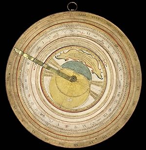
Planispherum Lunare cujus ope Locus medius Solis Lunae, ejusdemque Nodorum, Solis Declinatio, Lunaeque Latitudo Simplex, atque ejus Argumentum, necnon Novitunia et Plenitania Ecliptica simul inveniuntun.
Edité par [c1800], 1800
Vendeur : Daniel Crouch Rare Books Ltd, London, Royaume-Uni
Membre d'association : ABA ILAB PBFA
Evaluation du vendeur :
Manuscrit / Papier ancien
A unique manuscript lunar astrolabe Ink and polychromy on paper over pine. The instrument comprises a circular base plate, and three rotatable cardboard volvelles, and a brass radius pointer, attached to each other in the centre. A brass ring is attached to the base plate for suspending. All four paper covered discs are finely inscribed in manuscript with various scales and symbols. Content 1. The smallest volvelle bears a scale covering 12 hours on its outer ring. It also shows the ecliptical motion of the Sun, the Moon's orbit, the line of nodes, and the arguments of latitude (in other words, the distances from the nodes). 2. On the second volvelle, a scale covers the years from 1801 to 1825. each year is subdivided in twelve months, with the abbreviated name written for each month. 3. The following volvelle carries a series of scales showing a monthly calendar, a zodiac calendar with skilfully drawn pictures and the symbols of the signs. Below the zodiac is a scale for the declination of the sun throughout the year, set in four sequences of three. 4. On the outside rim of the volvelle is another calendar scale in which the months are unevenly distributed. This scale presumably was to be used in conjunction with the outer scale on the circular base plate. In addition, the volvelle holds two brass studs that most probably helped the user turn the disc to the desired position. This latter scale gives the days, subdivided in hours. The days are numbered I to XXXI, with the number I coinciding with XXVII and 8 hours (the sidereal period of the Moon), which results in a double numbering from XXVIII to XXXI. Below this scale for days, there is a series of dates, all confined to the period 1801 to 1825, presumably for solar eclipses. The brass rule or pointer holds a horizontal scale from 5 to 0 (LA-southern declination) and from 0 to 5 (LB-northern declination), indicating the latitude of the moon with respect to the ecliptic. The closer to 0 at new moon or full moon, the likelier an eclipse is to occur. The rule is engraved with "Locus Lunae". The circular scales serve to set the moon's position and node relative to the sun, from which the user can then infer the lunar phase and whether an eclipse will occur at new moon or full moon. Manuscript instruments of this type are rare, especially in such good condition, as no other exact copy is recorded to date. Similar instruments were produced at the end of the sixteenth century, mostly in brass. Sir Robert Dudley (1573-1649, see item 17) had a lunar calculator made by Charles Whitwell (c. 1568-1611) a brass disc of 72 cm diameter overall, which was the most complex instrument made during the sixteenth century. Inscribed 'Sir Robert Dudley was the inventor of this instrument', its purpose was to calculate the place of the moon over a period of thirty years. It is now in the Museo di Storia della Scienza in Florence, Italy. Another similar paper device was printed, with detailed instructions, in 1786 in Vlissingen (Flushing) in the Netherlands, advertised as a "Starkundige Maan-Wyzer en Almanach" (Astronomical Moon Pointer and Almanac) by Henricus Schortinghuis. Oxford Dictionary of National Biography; Webster, Roderick and Marjorie, 'Western Astrolabes', Adler Planetarium & Astronomy Museum, 1998; Museo di Storia della Scienza, Florence, Italy.
-
A Map of the most Inhabited part of New England containing the Provinces of Massachusets Bay and New Hampshire, with the Colonies of Conecticut and Rhode Island, Divided into Counties and Townships: The whole composed from Actual Surveys and its Situation adjusted by Astronomical Observations
Edité par Thomas Jefferys, London, 1764
Vendeur : Donald A. Heald Rare Books (ABAA), New York, NY, Etats-Unis
Membre d'association : ABAA ILAB
Evaluation du vendeur :
Carte Edition originale
Copper-engraved map, on four unjoined and untrimmed sheets as issued. The largest and most detailed map of New England that had yet been published, and one of the great maps of the east coast of America, by one of the greatest figures in 18th-century cartography: 'Mead's contributions to cartography stand out . At a time when the quality and the ethics of map production were at a low ebb in England, he vigorously urged and practiced the highest standards' (Cumming, p.47). This is the grandest, most accurate and detailed map of New England produced during the British colonial period. It depicts the entire region from Long Island Sound up north to line of 44'30 of latitude. While it shows that the coastal areas, and the lower Connecticut Valley were well settled, areas of the interior, especially in New Hampshire and the future Vermont were just developing, with the early boundaries of townships having recently been established by surveyors. Importantly, this map contains two highly-detailed cartographic insets, one of the city of Boston (upper-left), and another of Boston Harbor on the lower-right sheet. The map is also adorned with a very handsome pictorial title cartouche, depicting the arrival of the Pilgrims at Plymouth Rock in 1620. The present map is the first issue of the second edition of this work, and has been significantly updated from the original issue of 1755. The map's publisher, Thomas Jefferys was the leading British mapmaker of the mid-eighteenth century. He became geographer to the Prince of Wales in 1746 and then to King George III in 1760. He published a remarkable number of maps and charts, and is best known for his work The American Atlas (1775) This map's maker, John Green, was an intriguing and larger-than-life figure, who has been called "the genius behind Jefferys." In addition to his extensive cartographic abilities, Green's personal history also stands out from amongst the biographies of other 18th-century British map makers. Green was born Braddock Mead in Ireland around 1688, married in Dublin in 1715 and moved to London in 1717. He was imprisoned in 1728 for trying to defraud an Irish heiress, and assumed his alias after his release from prison. He worked with Ephriam Chambers on his Universal Dictionary before joining the employ of Cave, Astley, and Jefferys. William Cumming remarked that he 'had a number of marked characteristics as a cartographer . One was his ability to collect, to analyze the value of, and to use a wide variety of sources; these he acknowledged scrupulously on the maps he designed and even more fully in accompanying remarks. Another outstanding characteristic was his intelligent compilation and careful evaluation of reports on latitudes and longitudes used in the construction of his maps, which he also entered in tables on the face of the maps . Mead's contributions to cartography stand out . At a time when the quality and the ethics of map production were at a low ebb in England, he vigorously urged and practiced the highest standards; in the making of maps and navigational charts he was in advance of his time. For this he deserves due credit.' (Cumming, p.45) Degrees of Latitude, 35; McCorkle, New England in Early Printed Maps, 755.19 (first edition/state); Sellers & Van Ee, Maps & Charts of North America & West Indies, 799; Stevens & Tree, "Comparative Cartography," 33(c), in Tooley, The Mapping of America. Cf. Crone, "John Green. Notes on a neglected Eighteenth Century Geographer and Cartographer," Imago Mundi, VI (1950) p. 89-91; Crone, "Further Notes on Braddock Mead, alias John Green" Imago Mundi, VIII (1951) p. 69; Cumming, British Maps of Colonial America, pp.45-47.
-
A New Terrestrial Globe J. Newton 1783.
Edité par London,, 1783
Vendeur : Daniel Crouch Rare Books Ltd, London, Royaume-Uni
Membre d'association : ABA ILAB PBFA
Evaluation du vendeur :
Manuscrit / Papier ancien
Newton's first pocket globe Globe, 12 hand-coloured engraved paper gores, clipped at 65 degrees latitude, with two polar calottes, over a papier mâché and plaster sphere, varnished, housed within original shagreen over paste-board clamshell case, with hooks and eyes, lined with 12 hand-coloured engraved celestial gores, with two polar calottes, varnished. The case split in both halves where hinge would have been, loss to exterior and minor loss to celestial gores. Biography During the first half of the nineteenth century the firm of Newton, together with Bardin and Cary, occupied a leading position in the manufacture of globes in London. The firm was established by John Newton in 1783 and operated originally from the Globe & Sun 128 Chancery Lane, moving to 97 Chancery Lane in 1803, before settling at 66 Chancery Lane in 1817. John Newton (1759-1844) was trained by Thomas Bateman (fl1754-81), who had previously been apprenticed to Nathaniel Hill (fl1746-1768). Newton's first globe was a revised edition of Hill's 1754 pocket globe, which he published in 1783 in association with William Palmer. The partnership dissolved shortly after, and Newton continued to publish the pocket globe under his own name. John's second son William Newton (1786-1861) joined the firm between 1814-1816, which traded under the name J. & W. Newton. In the same year the firm produced a new series of globes, including a new pocket globe. By the 1830s the firm was also active as a patent agent and was joined by Miles Berry, a civil engineer and patent agent, after which the firm was known as Newton, Berry & Son. In 1842, William's eldest son, William Edward Newton (1818-1879), joined the business, followed by his brother Alfred Vincent Newton (1821-1900). The firm became known as W. Newton & Son, or once again, on the death of William, as simply Newton & Son from 1861 until about 1883. Perhaps the greatest triumph for the Newton family was the Great Exhibition of 1851, where, aside from the globes they exhibited from 150 to 635mm (1 to 25 inches) in diameter, they were awarded a prize medal for a manuscript terrestrial globe of six feet in diameter. Geography Newton used Hill's copper plates from his 1754 pocket globe for the present globe with a number of alternations and updates. He has changed the text within the cartouche to feature his own name, however he retains the rococo cartouche that Hill used. Newton added Captain Cook's track and updated the Australian coastline with his discoveries, including "New Holland", "New South Wales", "Botany Bay", "Dimens Land", "Lewins L[and]", the "I[sles of ] St Francis" and "New Zeeland". The globe shows the equinoctial graduated in degrees, and the conforming ecliptic is highlighted in green. The prime meridian passes through London, and the principal land masses are outlined in colour and annotated with some of the major rivers and mountain ranges. The oceans show the winds with islands labelled and printed with dotted lines for Admiral Anson's Tract and the tract of Captain Cook's first voyage in 1760, while, the North Pacific region features a rococo scroll title cartouche. Astronomy The gores are pasted to the inside of the case, and the cartography features stars expressed in varying orders of magnitude and allegorical representations of the constellations finely executed. Dekker GLB0029; Dekker and van der Krogt, fig.57; for reference see Dahl and Gauvin, pp.93-95; van der Krogt, Hil 1 and Hil 4; Worms and Baynton-Williams, pp.318-319; Dekker, pp.355-357.
-
Journal of a Voyage to New South Wales with Sixty-five Plates of Non descript Animals, Birds, Lizards, Serpents, curious Cones of Trees and other natural Productions.
Edité par London: J. Debrett, 1790, 1790
Vendeur : Arader Galleries - AraderNYC, New York, NY, Etats-Unis
Evaluation du vendeur :
Edition originale
4to., (12 4/8 x 10 inches). Engraved title-page with a vignette view of Port Jackson (a bit spotted), one-page publisher's advertisement at beginning, list of subscribers, 4-page publisher's advertisement at end (page 157 with short closed tear affecting the text, one or two insignificant spots). 65 fine engraved plates after drawings by Sarah Stone, Mr. Catton, Mr. Nodder and others, all with original hand-colour. Uncut in a fine modern binding of calf, gilt, to an 18th-century style by Trevor Lloyd. Provenance: from the library of Michael Lerner, his sale, Bonhams, 16th April 2012, lot 5140 First edition, and an attractive copy of the deluxe edition with the fine plates hand-coloured, 2H4 and 2K4 are cancels. John white joined the navy in his twenties, and in 1786 "he became surgeon of the 'Irresistible', and four months later, on the recommendation of Captain Sir Andrew Snape Hamond, he was appointed chief surgeon of the expedition to establish a convict settlement at Botany Bay. Of almost 1500 people in the eleven ships of the First Fleet 778 were convicts, many in poor health from long imprisonment. It is to the credit of White and his assistants that on the voyage of more than eight months there were only thirty-four deaths. Outbreaks of scurvy and dysentery and lack of accommodation for the sick were his first problems in the new colony. Within a year the incidence of sickness was greatly decreased, a hospital was built, and White, a keen amateur naturalist, found time to accompany Governor Arthur Phillip on two journeys of exploration. On joining the First Fleet White had begun to keep a journal, in which he made many notes of birds examined in the colony. In November 1788 he sent this to a London friend, Thomas Wilson; edited probably by Wilson it was published in 1790 as [here] "Journal of a Voyage to New South Wales". Accompanying the text were sixty-five engravings illustrating the natural history and products of the colony, drawn in England from specimens sent by White, with descriptions by English specialists. He also sent drawings and possibly specimens for "The Voyage of Governor Phillip to Botany Bay" (London, 1789). His own book was a big success. A German edition followed, and later there were translations into Swedish and French (Australian Dictionary of Biography online). Many artists were responsible for drawing the specimens that White sent back to England into the care of Sir Ashton Lever, including the celebrated Sarah Stone (ca 1760-1844). In addition to White's specimens Lever's Holophusikon contained a number of objects collected on Captain Cook's second and third voyages, which he commissioned Stone to paint in the 1770s, she continued to paint at the Leverian Museum throughout the 1780s and started painting the many ethnographical items in 1783. Abbey Travel 605: Ferguson 97; Hill 1858; Nissen ZBI 4390. Catalogued by Kate Hunter.
-
The Life of Samuel Johnson, LL.D. Comprehending An Account of his Studies and Numerous Works, in Chronological Order, A Series of his Epistolary Correspondence and Conversations with Many Eminent Persons; And various Original Pieces of his composition, never before published. The Whole exhibiting a View of Literature and Literary Men in Great Britain, for near half a Century, during which he flourishes. In Two Volumes. By James Boswell, Esq. Volume The First. [Second.]
Edité par London: Printed by Henry Baldwin, for Charles Dilly, in The Poultry, 1791
Vendeur : Symonds Rare Books Ltd, London, Royaume-Uni
Membre d'association : ABA ILAB
Evaluation du vendeur :

Livre Edition originale
Hardcover. Etat : Very Good. 1st Edition. [with tipped in Boswell autograph]. FIRST EDITION, Second issue (reading "give" spelled correctly on p.135). 2 Volumes. 4to. Vol. 1: Engraved frontispiece portrait. (2), iv-xii, (8), 516 pp.; [A4], [-2], A-B4, B-Zz4, 3A-3T4, 3U2; Vol. 2: (2), 588 pp. [A]2, B-4E4, 4F1. [A]1 blank. Engraved plates facing N2v (p. 92) and 4F1v (p. 588). Vol. 2 lacking initial blank; occasional marginal pencil notes (vol. 2). Small leather bookplate of Barton Currie to front pastedowns of both volumes; small newspaper clipping pasted to rear pastedown (vol. 2). Occasional faint spotting; untrimmed pages. Contemporary original marbled paper boards with contemporary brown calf spine; original red morocco spine labels with gilt lettering; insignificant light rubbing; hinges a little tender. Housed in a modern morocco-backed drop-back box. A fine copy. Rothschild 463. Untrimmed and in a beautiful and extremely well-preserved contemporary binding, this is a superb and exquisite FIRST EDITION of one of the most famous literary biographies ever published. It comes from the collection of the prominent American journalist and avid and distinguished bibliophile Barton Currie. This attractive copy includes the wonderful engraved portrait of Johnson made by J. Heath after the famous painting by Joshua Reynolds and two other beautifully engraved plates a facsimiles of Johnson s handwriting and a Round Robin with facsimiles of signatures. Boswell s The Life of Samuel Johnson is considered by some as one of the greatest biographies ever written in the English language. Boswell's personal acquaintance with Johnson began in 1763, and the author covered the entirety of Johnson's life by means of additional research. The biography does indeed take many critical liberties with Johnson s life, since Boswell makes some changes to Johnson s quotations and even censors many comments. This is why some contemporary critics have stated that it cannot be considered a proper biography. However, the book is valued as both an important source of information on Johnson and his times, as well as an important work of English literature.
-
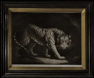
Tyger.
Edité par John & Josiah Boydell, Cheapside, & at the Shakespeare Galleryy Pall Mall, May 1, 1790., London,, 1790
Vendeur : Daniel Crouch Rare Books Ltd, London, Royaume-Uni
Membre d'association : ABA ILAB PBFA
Evaluation du vendeur :
Photographie
Northcote's striking print of the tiger Mezzotint. James Northcote (1746-1831), born in Plymouth he was apprenticed at an early age to his father who was a watchmaker. In is spare time the young James painted and sketched. In 1769, he left his father and set up a portrait painter; four years later he travelled to London and was admitted as a pupil into the studio and house of Sir Joshua Reynolds. In 1775 he left Reynolds, and about two years later, having made some money by portrait painting back in Devon, he went to study in Italy. On his return to England, three years later, he revisited his native county, then settled in London, where John Opie and Henry Fuseli were his rivals. He was elected associate of the Academy in 1786, and full academician in the following spring. The range of his output was considerable from history paintings such as the "Young Princes Murdered in the Tower" (1786), and the "Death of Wat Tyler" (1787); to genre scenes such as the "The Modest Girl and the Waton", although he is best remembered for his fine portraits and the natural history paintings. His prodigious output would number about 2000 works and he would amass a not inconsiderable fortune of Ł40,000. Dictionary of National Biography, vol. 41, p.190-193, 1895.
-
A New Terrestrial Globe by Nath Hill 1754.
Edité par Nath. Hill, 1754 [but c1755 or later]., 1754
Vendeur : Daniel Crouch Rare Books Ltd, London, Royaume-Uni
Membre d'association : ABA ILAB PBFA
Evaluation du vendeur :
Manuscrit / Papier ancien
No Binding. Etat : Fine. Showing the results of Bering's expedition to the Kamchatka Peninsula Globe, 12 hand-coloured engraved paper gores, clipped at 65 degrees latitude, with polar calottes, over a papier mâché and plaster sphere, varnished, housed within original shagreen over paste-board clamshell case, with hooks and eyes, lined with two sets of 12 hand-coloured engraved celestial gores, varnished. The terrestrial globe a bit toned. Biography Nathaniel Hill (fl1746-1768) was a surveyor, mathematician and instrument maker based in London. He started his career as an apprentice globemaker to Richard Cushee, and he later took on Cushee's nephew, Leonard, as his apprentice. His shop was at the Globe and the Sun in Chancery Lane, and his trade card advertised "New and Correct Globes of 3, 9, 12 and 15 inches". Hill's most popular items were the three and nine-inch globes, which he published either as pocket globes, mounted on a stand or for orreries. After Hill's death, his business was continued by Thomas Bateman, who took on John Newton and William Palmer as apprentices. Geography This pocket globe by Hill shows the rapid changes in European knowledge of the world. Although it bears the same date as another globe he published in 1754, it shows some significant revisions, the most obvious of which is the addition of trade winds. In Asia, the Caspian Sea has been reduced in width to reflect the findings of the Russian nautical surveyor, Feodor Soimonov, who thoroughly surveyed the sea for the first time between 1719 and 1727, and published his findings in 1731. The most significant development is the redrawing of eastern Russia, influenced by Vitus Bering's second expedition to the Kamchatka Peninsula. Bering spent ten years (1733-1743) exploring along northern Russia, mapping the Arctic coast of Siberia, and reaching Alaska in North America. Bering died of scurvy during the voyage, and an island off the Kamchatka Peninsula was eventually named in his honour. Stephan Krasheninnikov published the first detailed description of the peninsula, 'An Account of the Land of Kamchatka' in 1755, which is possibly where Hill acquired the new information. Astronomy The celestial gores, lining the case, are geocentric in orientation and, in a departure from most previous pocket globes, are concave, thus depicting the constellations as seen from earth. Previous pocket globes, most notably John Senex's pocket globe of 1730, simply used gores intended for celestial globes, thus rendering the night sky in reverse when pasted to the inside of the case. The difference is most noticeable in the orientation of Ursa Major, with the bear facing in the other direction. For Hill's 1754 pocket globe see Dahl and Gauvin, pp.93-95 (Stewart Museum 1979.28.2); for reference see Dekker, pp.355-357; van der Krogt, Hil 1 and Hil 4; Worms and Baynton-Williams, pp.318-319.
-
Faits memorables des empereurs de la Chine, tirés des annales chinoises [.] gravées [.] d'aprčs les dessins originaux de la Chine [.] tirés du cabinet de Mr. Bertin.
Edité par Paris, Helman and Nicholas Ponce, 1788., 1788
Vendeur : Antiquariat INLIBRIS Gilhofer Nfg. GmbH, Vienna, A, Autriche
Membre d'association : ILAB VDA VDAO
Evaluation du vendeur :
4to. Wholly engraved series, consisting of a title-page, dedication, 24 illustrations and 24 text pages, all printed on one side of a leaf. (With) II: Helman, Isidore-Stanislas. Abrégé historique des principaux traits de la vie de Confucius célebre philosophe chinois [.] gravées [.] d'aprčs des dessins originaux de la Chine envoyés ŕ Paris par M. Amiot missionaire ŕ Pékin [.]. Paris, Helman and Nicholas Ponce, [1788]. Wholly engraved series, consisting of a title-page, 24 illustrations and 28 text pages, all except 8 of the text pages, printed on one side of a leaf. 2 works in 1 volume. Later gold-tooled, mottled calf, gold-tooled spine, sides, binding edges and dentelles, gilt edges. Deluxe issue, printed on wove paper, of two handsomely engraved print series, with each print accompanied by an engraved text leaf. - The first series is a radically revised version of Dijian tushuo, designed to appeal to educated Parisians. The Dijian tushuo, known in English as The emperor's mirror, was a very popular Chinese work with stories and illustrations of the praiseworthy and blameworthy actions of Chinese emperors, originally composed for the instruction of the young Wanli emperor. A manuscript version of this work was sent to the French minister of finance Henri Bertin, after which Helman modelled his edition. Besides reframing the Chinese historical anecdotes for a French audience, Helman also completely reconceptualised the illustrations. Although Helman intended to publish four instalments, only the present first instalment appeared. "Published in Paris just a year before the French revolution, perhaps the volume was meant as a veiled criticism not only of Louis XVI's policies but also of his wife, Marie-Antoinette" (Reed & Demattč). - The second series is also based on a collection of drawings from the library of Bertin, who had received these from the French Jesuit missionary Joseph-Marie Amiot. Amiot wrote a lengthy biography of Confucius, which was published as "Vie de Koung-Tsée, appellé vulgairement Confucius", together with the engravings by Helman, in 1786, simultaneously with the first impression of the present print series. The accompanying text to the plates are short "morales de Confucius" from the "Collection des moralistes anciens" (1782). - As stated on the title-page, part 1 could be purchased unbound, at 12 livres; in paper wrappers, at 13 livres and 10 francs; unbound on wove paper for 18 livres; on large paper to accompany the Batailles de la Chine and hand-coloured on "papier de Hollande". Both series are here printed on wove paper, and part 2 (usually dated 1786) is, as such, clearly issued together with the other in 1788. - Isidore-Stanislas Helman (1743-ca. 1810), a student of Le Bas, was a successful engraver in service of the Duke of Chratres. In 1785 he had reproduced a then already extremely rare print series illustrating Chinese battles, that was commissioned by the Emperor of China in France. Helman would later engrave the major events of the French Revolution. - A couple of occasional spots and some very minor foxing in the upper margins, otherwise a very good copy. The binding has some minor wear along the extremities of the spine, but is also very good. - Cohen/De Ricci 479. Cordier, La Chine en France au XVIIIe sičcle, pp. 59f. Cordier, Sinica, 587f. Journal de Paris, 9 oct. 1786, p. 1167. J. K. Murray, "Narrative and visual narrative across disciplines and cultures", in: A. Green, Rethinking Visual Narratives from Asia (2013), pp. 21-22. Löwendahl 647 & 654. Lust 729 & 1133. Reed & Demattč 21f. & pp. 43-45.
-
Relación Histórica de la vida y apostólicas tareas del Venerable Padre Fray Junípero Serra, y de las misiones que fundó en la California septentrional, y nuevos establecimientos del Monterey
Edité par Imprenta de Don Felipe de Zuniga y Ontiveros, calle del Espiritu Santo, Mexico, 1787
Vendeur : Donald A. Heald Rare Books (ABAA), New York, NY, Etats-Unis
Membre d'association : ABAA ILAB
Evaluation du vendeur :
Edition originale
Small quarto. [28], 344pp. 1 engraved portrait, 1 folding engraved map. (Abrasion on top edge of text block). Contemporary vellum, manuscript title on spine (lightly rubbed, ties lacking). Housed in a half morocco and cloth folding box, spine gilt. A primary source for information on the history of early California. An outstanding book on early California. Palou was a disciple of Father Junipero Serra (1713-1784) for many years, and his work is still the principal source for the life of the venerable founder of the California missions. "The letters from Father Serra to Father Palou [provide] interesting details on the various Indian tribes and their manners and customs, together with descriptions of the country.This work has been called the most noted of all books relating to California" (Hill). "Both a splendid discourse on the California missions, their foundation and management, and an intimate and sympathetic biography of the little father-present. Better, by long odds, than the bulk of lives of holy men, written by holy men" (Libros Californianos). The map shows the locations of nine missions (of an ultimate total of twenty-one) and also the presidios at San Diego, Santa Barbara, Monterey, and San Francisco. "[The map] is of interest here because it seems to be the first on which a boundary line was drawn between Lower and Upper California" (Wheat). The plate is a portrait of Serra. First edition, second issue, with "Mar Pacifico" printed on the map (see Wagner). This is also the issue of the text with "car" instead of "pro" at the end of the index and with the phrase "a expensas de various bienhechores" preceding the imprint on the titlepage. Barrett 1946; Cowan, p.472; Graff 3179; Hill (2004) 1289; Howes P56, "c"; LC, California Centennial 34; Libros Californianos, pp.24,67; Wagner Spanish Southwest 168; Weber p.77; Wheat Transmississippi 208; Zamorano 80, 59.
-
Manuscrit inédit intitulé "Mémoires pour servir ŕ l'histoire du publicanisme moderne contenant l'origine, les noms, qualités, le portrait et l'histoire abrégée de nosseigneurs les fermiers généraux du Roy qui se sont succédés depuis l'année 1720 jusqu'ŕ la présente année 1750" [avec] "Mémoires pour servir ŕ l'histoire du publicanisme ou l'Origine des receveurs généraux des finances du royaume"
Date d'édition : 1750
Vendeur : Librairie Le Feu Follet, Paris, France
Membre d'association : ILAB
Evaluation du vendeur :
Livre Edition originale Signé
Couverture rigide. - s.l. 1750, in-folio (23x38cm), 330 pp. (4 p. bl.) (8 p.) (4 p. bl.) 83 pp., 2 manuscrits reliés en un volume. - | Un manuscrit unique et enluminé : le Who's Who des Fermiers généraux | Important et long manuscrit composé de deux parties rédigées par deux mains différentes retraçant au total 160 biographies des Fermiers Généraux en activité entre 1720 et 1750, fastueux et impopulaires percepteurs des impôts indirects dans l'Ancien Régime. Chacune des parties contient en outre un trčs utile index. Les entrées - sauf 19 d'entre elles - sont toutes ornées d'un blason dessiné ŕ la mine de plomb, peint ŕ la main en couleurs et parfois rehaussé d'or ou d'argent. Quelques notes modernes (certaines savoureuses) au crayon en marge de certains feuillets. Ces mémoires n'ont jamais fait l'objet d'une publication et on ne connaît que quelques copies manuscrites aux textes variables. Les autres exemplaires que nous avons pu trouver, y compris celui numérisé par la Bibliothčque nationale de France, contiennent moins de biographies que le nôtre et ne sont pas illustrés. Reliure de l'époque en plein veau blond marbré, dos lisse richement orné, pičces de titre de maroquin noir et rouge, gardes et contreplats de papier ŕ la cuve, dentelle dorée en encadrement des contreplats, toutes tranches rouges et dorées. Restaurations anciennes au niveau des mors, du plat supérieur et des coiffes, mors du premier plat intégralement fendu mais toujours solidaire, épidermures sur les plats, deux coins émoussés. Trčs beau manuscrit, richement peint, retraçant l'histoire de l'institution la plus honnie de l'Ancien Régime. Provenance?: bibliothčque du Comte Chandon de Briailles, descendant des fondateurs de la fameuse maison de Champagne puis de la bibliothčque Michel de Bry avec sa devise «?Pro captu lectoris?» avec leurs ex-libris encollés sur les gardes initiales. [ENGLISH TRANSLATION FOLLOWS] Manuscript entitled "Mémoires pour servir ŕ l'histoire du publicanisme moderne contenant l'origine, les noms, qualités, le portrait et l'histoire abrégée de nosseigneurs les fermiers généraux du Roy qui se sont succédés depuis l'année 1720 jusqu'ŕ la présente année 1750" [with] "Mémoires pour servir ŕ l'histoire du publicanisme ou l'Origine des receveurs généraux des finances du royaume" 1750 | folio (23 x 38 cm) | 330 pp (4 p. bl.) (8 p.) (4 p. bl.) 83 pp. | contemporary full calf Important and long manuscript composed of two parts written by two different hands retracing in total 160 biographies of the Fermiers Généraux active between 1720 and 1750, lavish and unpopular collectors of indirect taxes in the Ancien Régime. Each of the parts also contains a very useful index. The entries - with the exception of 19 of them - are all decorated with a coat of arms drawn in pencil, painted by hand in colour and sometimes enhanced with gold or silver. Some modern notes (some juicy) in pencil in the margin of certain leaves. These memoirs have never been the object of a publication and we know of only a few handwritten copies with varying texts. The other examples that we have been able to find, including the one digitised by the French National Library, contain fewer biographies that ours and are not illustrated. Contemporary binding in full blond marbled calf, title pieces in black and red morocco. Joints, top of the first board and spine head repaired, joints of the first board split but solid, scratches on the boards, corners damaged. A very beautiful manuscript, richly painted, retracing the history of the most despised institution of the Ancien Régime. Provenance: library of Count Chandon de Briailles, descendent of the founders of the famous house of Champagne, then of the Michel de Bry library with its motto "Pro captu lectoris" with their ex-libris glued to the first endpapers. 330 pp. (4 p. bl.) (8 p.) (4 p. bl.) 83 pp.
-
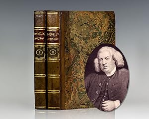
The Life of Johnson.
Edité par Printed by Henry Baldwin, for Charles Dilly, in The Poultry, London, 1791
Vendeur : Raptis Rare Books, Palm Beach, FL, Etats-Unis
Evaluation du vendeur :
First edition, first issue of both volumes ofÂthe most celebrated biography in the English language, whichÂwas published on May 16, 1791 in a print runÂof onlyÂ1,750 copies. Quarto, bound in contemporary half calf over marbled boards. Frontispiece portrait of Samuel Johnson, engraved by J. Heath after the Sir Joshua Reynolds (1756) painting. Volume one is the first state with the word â giveâ reading on page 135, line 10. First state of volume two, with two engraved illustrations, â The Round Robinâ at p. 92, and the â facsimilesâ of Dr. Johnson's handwriting on p. 588. In near fine condition with light toning, an excellent example of this landmark work. â Boswell excelled in insight into human nature and in ability to dramatize a situationâ ¦ It was a crucial part of Boswellâ s magic to give significance and vitality to the apparently trivial; it is this trait, together with his notable accuracy and unparalleled completeness of portraiture, that made himâ ¦ â the Shakespeare of biographersâ (Baugh et al., 1065-66). "One of Western literature's most germinal achievements: unprecedented in its time in its depth of research and its extensive use of private correspondence and recorded conversation." (Gordon Turnbull, Oxford DNB).
-
ENCYCLOPĆDIA; OR, A DICTIONARY OF ARTS, SCIENCES, AND MISCELLANEOUS LITERATURE.
Edité par Thomas Dobson, Philadelphia, 1798
Vendeur : William Reese Company - Americana, New Haven, CT, Etats-Unis
Membre d'association : ABAA ESA ILAB SNEAB
Evaluation du vendeur :
Eighteen volumes. With 542 copperplate engravings, some folding. Large quarto. Contemporary red calf, spines gilt, leather labels. Some shelf wear, minor chipping to some spine ends, short splits to a handful of joints, front joint of volume nine holding by cords. Minor toning and foxing. 19th-century armorial bookplate on front pastedowns belonging to Charles Burrall Hoffman. Overall very good; a handsome and striking set. An excellent set of the "greatly improved" first American edition of the first encyclopedia printed in America, in a fantastic contemporary American binding. Dobson's ENCYCLOPĆDIA was profusely illustrated with over 500 copperplate engravings, constituting "the finest group of American engravings of the century" signifying the "coming of age of American book illustration," according to Wroth. The massive work is illustrated with 542 copperplates engraved by noted artists such as Robert Scott, James Thackara, E. Trenchard, the Smithers, John Vallance, James Akin, William Barker, Joseph Bowles, Francis Shallus, Henry W. Weston, Joseph Seymour, and others. The text comes from the third edition of the ENCYCLOPEDIA BRITANNICA, with some revisions, namely the section on America, which was written by Jedidiah Morse. Interestingly, the entirety of the work is printed on paper manufactured in Pennsylvania. While the text largely follows the third edition of the ENCYCLOPEDIA BRITANNICA, there is considerable added material, mainly related to the Americas and the United States. Subscribers included Thomas Jefferson, George Washington, Aaron Burr, and Alexander Hamilton. This copy includes the armorial bookplate of Charles Burrall Hoffman on each front pastedown. Hoffman was an 1846 Columbia University graduate and a descendant of a prominent New York family. A landmark publication, not just the largest printing project undertaken in America at the time, but one that marked "the end of printing in America as a household craft and the beginning of its factory stage of development" - Wroth. Richard D. Arner has written an excellent and thorough description of the history and production of the work. EVANS 22486. WROTH COLONIAL PRINTER, pp.291- 95. SILVER AMERICAN PRINTER, pp.153-54. LEHMANN-HAUPT 95. RINK 116. SABIN 22555. Richard D. Arner, DOBSON'S ENCYCLOPĆDIA: THE PUBLISHER, TEXT, AND PUBLICATION. (Philadelphia, 1991).
-
Sammelband of 45 papers on electricity extracted from Phil. Trans., including many by or relating to Frankin, Collinson, Wm. Watson and Benj. Wilson
Date d'édition : 1734
Vendeur : Jeremy Norman's historyofscience, Novato, CA, Etats-Unis
Membre d'association : ABAA ILAB
Evaluation du vendeur :
Edition originale
Franklin, Benjamin (1706-990). A letter of Benjamin Franklin, Esq; to Mr. Peter Collinson, F.R.S. concerning an electrical kite. Extract from Philosophical Transactions of the Royal Society 47 (1752): 565-567. 232 x 173 mm. In a Sammelband of extracts from the Philosophical Transactions containing 48 papers on electricity by Franklin and others, published between 1734 and 1764; complete listing available. Later half cloth, marbled boards, light wear, lower corners a bit bent. Light foxing and toning, occasional marginal dampstaining, but very good. A virtually impossible to duplicate collection of rare English-language papers on electricity from the key early decades from 1734 to 1764. It includes the first edition of four key papers by Benjamin Franklin, including the one on his famous kite experiment. "Until the middle of the eighteenth century electricity was known only in its static form, and the most important instrument in use was the Leiden jar for concentrating electricity, discovered accidentally by Pieter van Musschenbroek . . . With this and other instruments Franklin conducted a series of experiments during the years 1746-57 . . . The most dramatic result of Franklin's researches was the proof that lightning is really an electrical phenomenon. Others had made such a suggestion before himâ "even Newton himselfâ "but it was [Franklin] who provided the experimental proof. In 1752 he flew a kite in a thunderstorm and attached a key to its string. From this he collected electric charges in a Leiden jar and showed that atmospheric and frictional or man-made electricity are the same" (Printing and the Mind of Man, p. 119). Franklin's lightning experiments made his name famous throughout Europe, and "marked the coming of age of electrical science" (Dictionary of Scientific Biography). As is well known, Franklin communicated the results of his electricity experiments in a series of letters to the Royal Society in London. Our volume includes four additional Franklin papers, all of which first appeared in print in the Royal Society's Philosophical Transactionsâ " "A letter from Mr. Franklin to Mr. Peter Collinson, F.R.S. concerning the effects of lightning" (1752); "Electrical experiments, made in pursuance of those by Mr. Canton" (1755); "Extract of a letter concerning electricity, from Mr. B. Franklin to Mons. Delibard" (1755); and "An account of the effects of electricity in paralytic cases" (1757). In addition, the volume contains 43 papers on electricity from the Philosophical Transactions by some of Franklin's most notable contemporary "electricians," including Charles Du Fay, Stephen Gray, Granville Wheler, William Watson, Guillaume Mazeas, Jean Antoine Nollet, Benjamin Wilson, John Canton and Ebenezer Kinnersley. The papers, published between 1734 and 1764, provide a good representation of both the lead-in to Franklin's electrical investigations and the enormous scientific interest inspired by his results. .
-
![Image du vendeur pour [An original watercolor of a First Nations fishing encampment along a river] mis en vente par James Cummins Bookseller, ABAA](https://pictures.abebooks.com/inventory/md/md31692046712.jpg)
[An original watercolor of a First Nations fishing encampment along a river]
Edité par [Canada], 1800
Vendeur : James Cummins Bookseller, ABAA, New York, NY, Etats-Unis
Membre d'association : ABAA ILAB
Evaluation du vendeur :
Signé
Graphite, pen-and-ink and grey wash, on wove paper watermarked "W. Elgar 1796". 13 5/8 x 20 inches. Along the falls of a tree-lined river, two First Nations men are pulling a canoe into the water, directed by another in an elaborate feather headdress; a wigwam with mother and child is on the same shore to their left; across the river a longhouse and structure for smoking fish with another group of native people can be seen; at the far left a First Nations man is standing in his canoe fishing with a pole in the water just below the rapids. Although the 1796 watermark on the paper is consistent with drawings by Heriot, the unfinished quality of this work make attribution difficult. However, it is somewhat reminiscent of a smaller grisaille watercolor signed by Heriot titled FALLS OF THE POQUISQUE ON THE RIVER, ST JOHN on verso, sold at Waddington's March 15, 2018, lot 137. Furthermore, this scene is reminiscent of one described by Heriot in his Travels in the Canadas (1807) in which he describes Native American fishing on the cacasdes of St. Mary, nine miles below the entrance to Lake Superior: "It is at the bottom of the rapids, and even among their billows, which foam with ceaseless impetuosity, that innumerable quantities of excellent fish may be taken, from the spring until the winter; the species which is found in the greatest abundance is denominated by the savages, atticameg, or white fish; the Michilimakinac trout, and pickerell, are likewise caught here. These aflford a principal means of subsistence to a number of native tribes. No small degree of address, as well as strength, is employed by the savages in catching these fish; they stand in an erect attitude in a birch canoe, and even amid the billows, they push with force to the bottom of the waters, a long pole, at the end of which is fixed a hoop, with a net in the form of a bag, into which the fish is constrained to enter. They watch it with the eye when it glides among the rocks, quickly ensnare it, and drag it into the canoe. In conducting this mode of fishing much practice is required, as an inexperienced person may, by the efforts which he is obliged to make, overset the canoe, and inevitably perish." Trained by Paul Sandby at the Royal Military Academy, Woolwich (London), Heriot worked as a clerk for Board of Ordnance. "In 1792 [Heriot] was posted to Quebec and promoted clerk of the cheque in the Ordnance department. Heriot was to remain in Lower Canada until 1816, except, apparently, for two periods of absence, in 1796-97 and in 1806. His first years at Quebec are not well documented. Sketches record visits in and about Quebec and Montreal, perhaps on Ordnance business. In November 1792 he published a sketch of Jersey in the Quebec Magazine and the following year he prepared a view of Quebec, perhaps also intended for publication. When he returned to Britain in 1796 he resided in London, travelled to the south coast, and made at least one sketching foray into Wales . A watercolour prepared from his sketches of Wales and two Canadian views were accepted by the Royal Academy of Arts for exhibition in the spring. Heriot probably sailed for Lower Canada soon afterwards, taking notes and making sketches on the voyage. The impact of his visit to Britain was considerable. While there he had been stimulated by the art he had seen and by his success as an artist. He returned with a fresh enthusiasm for the Canadas; he began to read about their past and to make elaborate notes and numerous sketches of the places he visited and the peoples he encountered. His sojourn abroad had affected his artistic vision of the Canadas; his drawings and water-colours assumed a new confidence and his landscape forms developed a new strength and grandeur. In London he had probably studied the simply handled and remarkably strong water-colours of younger British artists such as Thomas Girtin, Joseph Mallord William Turner, and John Varley. Either in Britain or in Lower Canada he had also become familiar with Lieutenant George Bulteel Fisher*'s Six views of North America . (London, 1796). He was influenced by this work, especially by Fisher's use of the Picturesque in depicting Canadian landscape" (Dictionary of Canadian Biography). Corners clipped outside the image, verso toned Graphite, pen-and-ink and grey wash, on wove paper watermarked "W. Elgar 1796". 13 5/8 x 20 inches.
![Image du vendeur pour An East Prospect of the City of Philadelphia: taken by George Heap from the Jersey Shore, under the Direction of Nicholas Skull [sic] Surveyor General of the Province of Pennsylvania mis en vente par Arader Books](https://pictures.abebooks.com/inventory/md/md30901384945.jpg)
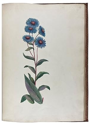

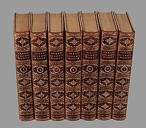
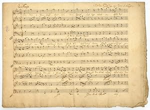

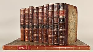
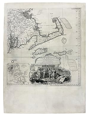
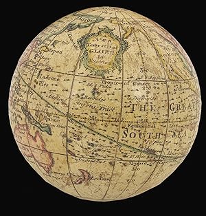
![Image du vendeur pour The Life of Samuel Johnson, LL.D. Comprehending An Account of his Studies and Numerous Works, in Chronological Order, A Series of his Epistolary Correspondence and Conversations with Many Eminent Persons; And various Original Pieces of his composition, never before published. The Whole exhibiting a View of Literature and Literary Men in Great Britain, for near half a Century, during which he flourishes. In Two Volumes. By James Boswell, Esq. Volume The First. [Second.] mis en vente par Symonds Rare Books Ltd](https://pictures.abebooks.com/inventory/md/md30938146574.jpg)
![Image du vendeur pour Faits memorables des empereurs de la Chine, tirés des annales chinoises [.] gravées [.] d'aprčs les dessins originaux de la Chine [.] tirés du cabinet de Mr. Bertin. mis en vente par Antiquariat INLIBRIS Gilhofer Nfg. GmbH](https://pictures.abebooks.com/inventory/md/md18617454643.jpg)
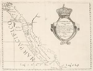
![Image du vendeur pour Manuscrit inédit intitulé "Mémoires pour servir ŕ l'histoire du publicanisme moderne contenant l'origine, les noms, qualités, le portrait et l'histoire abrégée de nosseigneurs les fermiers généraux du Roy qui se sont succédés depuis l'année 1720 jusqu'ŕ la présente année 1750" [avec] "Mémoires pour servir ŕ l'histoire du publicanisme ou l'Origine des receveurs généraux des finances du royaume" mis en vente par Librairie Le Feu Follet](https://pictures.abebooks.com/inventory/md/md31259880538.jpg)