Montant total (1 article articles) :
Destination de la commande :

geographie, Ancien ou d'occasion (Plus de 382 000 résultats)
Passer aux résultats principaux de la recherche
Type d'article
- Tous les types d'articles
- Livres (367 844)
- Magazines & Périodiques (953)
- Bandes dessinées (2)
- Partitions de musique (3)
- Art, Affiches et Gravures (2 116)
- Photographies (52)
- Cartes (9 455)
-
Manuscrits &
Papiers anciens (1 660)
Etat
Reliure
Particularités
- Edition originale (15 316)
- Signé (4 350)
- Jaquette (32 335)
- Avec images
- Sans impression ŕ la demande (382 084)
Livraison gratuite
Pays
Evaluation du vendeur
-
Cartes de Geographie Les plus Nouvelles et les plus Fideles
Edité par Paris: Chez l'Auteur, 1679., 1679
Vendeur : Arader Galleries - AraderNYC, New York, NY, Etats-Unis
Evaluation du vendeur :

Edition originale
Du VAL, Pierre (1619-1683). Cartes de Geographie Les plus Nouvelles et les plus fideles, Avecque leurs Divisions Regulieres, qui marquent les Bornes des Estats selon les derniers Traites de Paix. Paris: Chez l'Auteur, 1679. Folio (17 x 12 2/8 inches). Engraved "Introduction", "Alphabet et Definition des Termes", "Table Generale de Geographie", "Les Tables de Geographie reduites en un Jeu de Cartes" and two sheets of a games related to the German Empire (uncoloured), and one of place-names for Les Conciles; engraved allegorical title-page, fine double-page engraved double-hemisphere world map "Planisphere, ou Carte Generale de Monde", "Carte Universelle du Commerce", 1677 (Shirley 465, second state), and 89 double-page engraved maps, all with original hand-colour in outline. 19th-century tree sheep backed marbled paper boards, the spine in six compartments, with five raised bands, the second with maroon morocco lettering-piece, the others decorated with fine gilt tools (extremities a little scuffed, small abrasion to lower cover). Provenance: with 19th-century marginal manuscript scholarly annotations to L'Amerique autrement le Nouveau et Indes Occidentales Du Val's EXTREMELY RARE "Cartes Geographiques" (Pastoureau Duval II), was the only folio atlas published by him. It was initially a collection of du Val's own maps, with those of other authors, published in 1654, then 1665 and 1667. In 1677 du Val published a uniform collection of his grand four-part wall, and folio maps, with the allegorical frontispiece as here: an architectural border supporting two putti unveiling a large globe to a world of assorted grandees; beneath the pillared arch repose a gentleman traveller, a merchant with this bags of salt and pepper, a scientist illuminating his own hand, and a curious woman tending to her animals. The maps in this example of the "Cartes Geographiques" are EXCEPTIONALLY FINE, bright, clean and attractive examples, with original hand-colouring in outline, and include 2 world maps, double-hemisphere and on a Mercaor projection, 7 of his spectacular wall maps, 3 sheets of games, that seem to be the equivalent of our "Risk", and 89 detailed double-page maps, each detailed, but also beautiful for their elegant simplicity. Pierre du Val was the nephew of the celebrated French cartographer Nicolas Sanson d'Abbeville (1600-1667), mapmaker to Louis XIV, King of France, and responsible for sparking a renaissance in geographical endeavor in France, and laying the foundations for French domination in map production, initiating the so-called "French school of cartography," a school that was unprecedented in its attention to precision and scientific detail and which discarded much of the decorative embellishments of previous maps as irrelevant. Du Val adopted Sanson's geographical conceptions, confirming that the center of cartographic innovation had shifted from Holland to France. Du Val too was appointed to the position of Geographe ordinaire to Louis XIV, and justifiably so. The maps include, in order: - World maps: Planisphere, ou Carte Generale de Monde (Duval II D), double-hemisphere world map, surrounded by diagrams showing compass points, winds and planetary orbits, a small terrestrial globe and an armillary sphere - Carte Universelle du Commerce, Carte Hidrographique, ou. Les Costes des 4 Parties du Monde, Avecque les Routes pour la Navigation des Indes, Occidentales et Orientales 1677 (Shirley 465, second state, first published in 1674), on Mercator s projection showing the French and English routes to and from the East and West Indies, complete with galleons in full sail, the track of Le Maire across the Pacific, and an anonymous attempt to find a route to China and Japan through Hudson s Bay in 1665. This map perpetuates the myth that California is an island, and displays some of the misunderstandings about the largely unexplored northwest coast of North America, such as the Straits of Anian. The lower half of the map is do.
-
Atlas Geographique contenant la Mappemonde et les Quatre Parties avec les Differents Etats
Edité par Paris: Chez Lattre, 1784., 1784
Vendeur : Arader Galleries - AraderNYC, New York, NY, Etats-Unis
Evaluation du vendeur :
Folio (21 4/8 x 16 6/8 inches). Engraved title-page, 2-page manuscript contents listing 55 maps. 43 fine double-page engraved maps including Lattre's double-page and folding map of "des Etats-Unis de l'Amerique suivant le Traite de Paix de 1783", and Bonne's map of "Des Isles Antilles et de Golfe de Mexique; avec la Majeure partie de la Nouvelle Espagne." on 3 separate sheets, 12 full-page maps, all maps with original hand-colour in outline, many with additional original hand-colour in part (please ask for a complete list, map of Switzerland torn in half down the central fold). Contemporary tan calf (very worn). Provenance: contemporary French manuscript contents leaf, titles to verso of each map, and numbers to recto, Lattre's map of the United States with an interesting annotation on the verso listing in table form the population of, and the number of border disputes for each former colony since the 'constitution'. An important composite atlas, containing many fine maps dated between 1759 and 1784, by De l'Isle, Buache, Janvier, Zannoni, St. Angelo, Bonne, Jaillot, Robert, Vaugondy, and Lattre himself. Two maps are of the utmost importance, and are present here as superb examples: LATTRE, Jean (fl: 1743 - 1793). "Carte des Etats-Unis de l'Amerique suivant le Traite de Paix de 1783. Dediee et Presentee a s Excellence Mr. Benjamin Franklin." Paris: Lattre, 1784. 3 sheets joined (24 4/8 x 40 inches; 21 x 29 inches to the neat line). Fine folding engraved map of the United States of America after the signing of the Treaty of Paris in 1783, with engraved side panels detailing the principle events of the American Revolution from 1775-1781 colony by colony, with a fine and elaborately decorated allegorical cartouche of a galleon lower right, the title and dedication to Benjamin Franklin appearing on an unfurling sail, an inset of southern Florida and the Bahamas lower centre, and a list of the thirteen states and their capitals next to it, all with beautiful original hand-colour in outline and in full (one or two small holes where folds meet, and a little creased, but EXCEPTIONALLY BRIGHT AND ATTRACTIVE). Based on John Mitchell's iconic map of 1755, which was used to negotiate the Treaty of Paris in 1783 that ended the American Revolutionary War, Lattre's map was published in June of 1784, and is the first French map to depict the newly formed United States, and one of the earliest maps of the United States to use that term, and the first published after the final ratification of the Treaty by both France and Britain in February and April of 1784, respectively. Wallis's map of April 1783 precedes the signing of the Treaty by both nations, and Buell's map of April 1784 precedes ratification of the Treaty by Britain. As such the map extends to the east as far as eastern Canada and the important fishing banks off Newfoundland; and to the Mississippi River in the west, with the area west of the Allegany Mountains inhabited only by Indian nations and a few forts. The thirteen original British colonies are well defined with alternating body and border colours. Lattre's dedication of the map to Benjamin Franklin, who as American ambassador to France, represented the United States at the peace negotiations, "lends historical significance to the work," (Cappon). This was undoubtedly Lattre's most significant map In 1762 he published the 'Atlas Moderne' to accompany de la Croix's 'Geographie Moderne', and he also engraved maps for Robert de Vaugondy, Janvier and Bonne, all of whose work is represented in this atlas. (Lester Cappon, The First French Map of the United States; McCorkle, New England in Early Printed Maps, #784; Pritchard and Taliaferro, Degrees of Latitude, #70; Ristow, American Maps and Mapmakers, p. 63, reproduced on p. 65; Sellers & Van Ee, Maps and Charts of North America, p. 158). BONNE, Rigobert (1727-1795). Des Isles Antilles et de Golfe de Mexique; avec la Majeure partie de la Nouvelle Espagne.Paris: Lattre, 1782. Three.
-
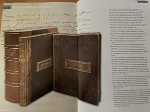
Wichtiges, bislang unpubliziertes, Tagebuch des deutschen Biologen Willemoes-Suhm von der Reise der HMS Challenger um die Erde 1872-1875. 2 Bände.
Vendeur : Antiquariat Kainbacher, Baden bei Wien, Autriche
Membre d'association : ILAB VDAO
Evaluation du vendeur :

an Bord der HMS Challenger 1872-1875. 4to. Band 1: 378 S., Band 2: 98 S. Mit zahlreichen Skizzen und Plänen im Text. Halblederbände der Zeit, in neuer Lederbox. Sehr gut leserliche Handschrift meist in deutscher Sprache. Original-Tagebuch des deutschen Biologen von der Reise der HMS Challenger. Gestorben auf Tahiti. Die letzten Eintragungen des Biologen stammen vom 2.September 1875 auf Hilo (Hawaii). Die Reise führte weiter Richtung Tahiti, unterwegs, am 13.September 1875 starb Willemoes-Suhm. Sein Tagebuch ist eine Fundgrube an Reisenotizen und wissenschaftlichen, sowohl zoologischen, als auch botanischen, Eintragungen. Unterteilt ist sein Tagebuch nach den Stationen, u.a. Azoren, St. Paul, Tristan-Inseln, Pince Edwards Islands, Crozet-Insel, Kerguelen, Antarktis, Australien, Neuseeland, Tonga, Fiji, Ovalau, Api, Neue Hebriden, Arafui, Ari, Ke Dulan, Ternate, Lamboanga, Manilla, Cebri, Humboldt-Bai ? Neu-Guinea, Yeddo, Yokohama, Hiogo. Yokohama ? Sandwich-Inseln, Honolulu, Hilo. 1872-1875. Important manuscript by one of the leading naturalists on the voyage. Original scientific travel journal titled ?Challenger? Rudolph von Willemoes Suhm ?Journal No.? ?I (& II).? Scientific Travel Journal of the German Explorer and Zoologists aboard HMS Challenger. Text in German but occasionally in English. 2 Vols. 21 Dec. 1872-6. Sept. 1875. 4to, 378; 98 pp., illustrated with sketches and 1 photograph, original half calf, fitted half morocco case. Autograph journal kept by the German naturalist Rudolf v. Willemoes-Suhm during his 3-year journey with the Challenger. Suhm was mainly concerned with Crustaceans, and several new species were named by him. His journal covers the entire voyage until his tragic death from erysipelas on 13th September,1875, while the ship was at Tahiti in the Pacific. His travel report remains unpublished and is a leading, yet apparently untapped source on the history of the Challenger Expedition as well as research and discovery of the sea. Suhm, born on 11. September 1847 in Glückstadt on the Elbe River studied in Bonn, Munich and Göttingen already at the age of 24 years he was a Professor of Zoology at the University of Munich. in 1872 he was appointed by Sir Charles Wyville Thomson, the Scientific Director of the Challenger Expedition as the only German on the staff of the research carried out on behalf of the Royal Society. The posthumous journal covers the entire period from Suhms trip to a few days before his death, in which his illness forced him to stop writing. It contains a wealth of information, particularly the geographical and zoological research of the ?Challenger? Suhm illustrated his records with small designs, including many maps and some small Zoological representations. Die britische Challenger-Expedition (1872-1876) war die erste rein wissenschaftliche Forschungsreise. Das Expeditionsschiff HMS Challenger legte bei Ihrer Reise ca. 130.000 km zurück und durchzog damit beinahe das gesamte Weltmeer. Mit dieser Expedition wurde der Grundstein für die Ozeanographie gelegt. Wichtige Forschungsstationen waren die Bahamas, die Marion-Inseln im südlichen Eismeer, Neuseeland, die Auckland-Inseln und Neu-Guinea. Die Ergebnisse wurden in 50 Bänden veröffentlicht.
-
Einzigartige Bild- und Text- Dokumentation eines deutschen Kaufmanns und Offiziers in Ostafrika, sowohl Portugiesisch-Ostafrika, als auch Deutsch-Ostafrika. Schulze, Ernst (1879-1952), Niederlassungsleiter der Deutsch-Ostafrikanischen Gesellschaft (DOAG) und Offizier. Sehr umfangreicher Nachlass mit über 700 Originalfotografien und mehreren Tausenden Seiten handschriftlicher Aufzeichnungen (Briefe, Tagebücher, Notizbücher, autobiographisches Material), Portugiesisch- und Deutsch-Ostafrika, Ägypten, u.a.
Vendeur : Antiquariat Kainbacher, Baden bei Wien, Autriche
Membre d'association : ILAB VDAO
Evaluation du vendeur :
1902-1919. Schulze, Sohn des Berliner Musikprofessor Johannes Schulze und Paten- und Schwiegersohn des Komponisten Ernst Rudorff (erster Dirigent der Berliner Philharmoniker und Begründer des deutschen Naturschutzes), Kaufmann und Offizier war nicht der typische Kolonialbeamte, sondern ein außergewöhnlich wissbegieriger und reflexiver Zeitgenosse, was sich nicht nur in den Bilder, sondern mehr noch in den sehr umfangreichen und akribischen Aufzeichnungen widerspiegelt, die eine detailgenaue Rekonstruktion seiner biographischen Stationen und Lebensbefindlichkeiten erlauben. Nach seiner Jugend in Berlin und Gro. Lichterfelde ließ sich Schulze in Hamburg zum Kaufmann ausbilden und ging 1902 für das Handelshaus Wm. Philippi & Co zunächst nach Portugiesisch-Ostafrika und wechselte später nach Deutsch-Ostafrika, wo er für die Deutsch-Ostafrikanische Gesellschaft die Niederlassungsleitung in Lindi übernahm. Die Stationen seines Wirkens im heutigen Mosambik und Tansania waren Mosambik (1902), Ibo (1902-1904), Porto Amelia (1904-1906), Tanga (1908), Mikindani (1908) und Lindi (ab 1908/09). Im Kolonialkrieg war Schulze, der später für das EK I vorgeschlagen wurde als Vizefeldwebel tätig. Nach einer Kriegsgefangenschaft in Maadi bei Kairo (1918/19) ließ er sich in Bielefeld nieder. Der Bildnachlass - über 700 Originalfotografien in zehn Alben - besteht größtenteils aus eigenen Aufnahmen (zumeist kleine bis mittlere Formate) von Schulze, der sich auf Expeditionen einen eigenen Träger für seine Fotoausrüstung hielt, enthält aber auch zahlreiche, meist großformatige Stücke ansässiger Fotoateliers (J.P. Fernandes , A.C. Gomes & Son in Sansibar, Carl Vincenti, Coutinho Bros., Monteiro in Daressalam, Zangaki, Peridis, Lichtenstern & Harari in Kairo). 8 Ordner "Meine Briefe aus Portugiesisch-Ost-Afrika /Deutsch-Ost-Afrika". 1 Ordner Kolonialkrieg: Berichte, Briefe, etc 1 Ordner Publikationen, Zeitungsausschnitte und Nachkriegskorrespondenz zu DOA. 1 Ordner Tendaguru: Dinosaurier-Grabung 1909/13 (Fotos, Berichte, Brief des Grabungsleiters Janensch, Sonderdrucke zur Grabung mit Widmung, Typoskript, Vortragsmanuskript, etc. 1 Ordner Zeichnungen eingeborener Kinder, Briefe in Swahili an Schulze. 30 Hefte, Notizbücher, Kladen: Autobiographie, Tagebücher, Notizen und Berichte. In dieser Form wohl einzigartiger Nachlass von forschungsgeschichtlicher Bedeutung!.
-
Die oberen Nil-Länder. Volkstypen und Landschaften. Dargestellt in 160 Photographien. Nach der Natur aufgenommen von R. Buchta. Mit einer Einleitung von Dr. Robert Hartmann.
Vendeur : Antiquariat Kainbacher, Baden bei Wien, Autriche
Membre d'association : ILAB VDAO
Evaluation du vendeur :
Berlin, Stiehm 1881. Daraus: 133 Original-Fotografien auf 87 Blatt. (Nicht vorhanden sind 11, 23, 30, 37, 54, 67, 78, 85, 89, 92, 94, 97, 101, und 104-110). Fotos in sehr guter Erhaltung. Original-Leinenkassette mit Goldprägung und Titel auf Vorderdeckel (etwas berieben), Beschriftung von alter Hand auf der Innenlasche der Kassette (Inhalt wie angegeben), und das seltene Textheft mit 8 Seiten Text von Robert Hartmann. Sehr selten! ? Buchta gilt als Pionier der Fotografie im Sudan. Seine ethnologischen Aufnahmen der Völker vor allem des Südsudan sind einzigartige Dokumente. Die Fotos zeigen beeindruckende Aufnahmen und Portraits von Häuptlingen und Angehörigen folgender Völker: Bischarin, Schukurieh, Schilluck, Bari, Madi, Schuli, Umiro, Nakatschupi und Kagaja, Magungo, Lango, Makraka, Abukaja, Niam-Niam, Monbuttu, Akka, Moru. Weitere Fotos zeigen Aufnahmen von Chartum, der österreichischen Missionsstation am Nil, von diversen Orten entlang des Nils, den Pyramiden von Meroe und eine Aufnahme von Lado in der Äquatorial-Provinz und den Murchison-Fällen. 1870 kam der Österreicher Richard Buchta (1845-1894) nach Kairo und arbeitete als Straßenfotograf. 1877 wurde er vom in ägyptischen Diensten stehenden, italienischen Gouverneur der Provinz Bahr el-Ghazal (Gazellenfluß) für fotografische Arbeiten im Sudan angeworben. 1878 begab er sich von Khartum nilaufwärts über Lado, wo ihn Emin Pascha (Gouverneur der Äquatorialprovinzen) aufnahm, nach Dufile, von wo er bis zum Albert-See und Uganda vordrang. In der Folge schloß er sich einer Expedition Emin Paschas an, die ins Königreich Bunyoro (im heutigen Uganda), südlich des Victoria-Sees, führte. Von der Reise mit reicher fotografischer Ausbeute zurückgekehrt, vermerkte Buchta: "Die Reise bot mir viele Genüsse, besonders durch die großartigen Vegetations-Scenerien in Unyoro, die an kraftstrotzender Üppigkeit Alles überbieten, was sich selbst eine kühne, weit gehende Phantasie vorstellen kann". Die auf dieser Reise aufgenommenen Fotografien und Zeichnungen wurden unter dem Titel "Die oberen Nilländer. Volkstypen und Landschaften", 1881 herausgegeben. In Petermann's Geographischen Mitteilungen vermerkte ein unbekannter Autor 1880: "Von R. Buchta, der unlängst von seiner Reise nach Uganda in die Heimath zurückgekehrt ist, liegt uns eine Reihe von Photographien vor, schöne und höchst interessante Blätter, über deren Ausführung man staunen muss, wenn man die schwierigen Verhältnisse kennt, unter denen sie aufgenommen wurden. Die Murchison-Fälle beim Victoria Nyanza, Ansichten des Nil im Bari Lande, des Mwutan, des Djebel Redjaf & c., alsdann Niam-niams, Monbuttu-, Bari- und Dinka-Neger und andere Typen der Bevölkerung am oberen Nil treten uns hier in frappanter Naturtreue entgegen". ? Paulitschke 120; Henze I,388f; Kainbacher 65.
-
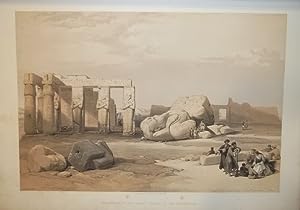
The Holy Land, Syria, Idumea, Arabia, Egypt & Nubia. With historical descriptions by George Croly and William Brockedon.
Edité par London, Moon, 1842 - 1849., 1842
Vendeur : Matthaeus Truppe Antiquariat, Graz, Autriche
Membre d'association : ILAB VDAO
Evaluation du vendeur :
Livre Edition originale
6 Bde. 3 Bll., 30 S., 21 Bll.; 23 Bll.; 2 S., 18 Bll.; 2 Bll., 8 S., 21 Bll.; 22 Bll.; 24 Bll. mit 120 Textabb. 3 Frontisp., 6 Titel, 1 Porträt, 118 Tafeln (alles in getönter bzw. farbig getönter Lithographie von Louis Hague), 2 Kupferkarten. Erste Ausgabe dieses epochalen Tafelwerks über den Nahen Osten mit allen 248 Ansichten des Heiligen Landes (in getönten Lithos) und Ägyptens (in farbig getönten Lithos). - Blackmer 1432. Lipperheide 1590 und 1591. Röhricht 1983. Abbey, Travel, 385 und 272. - "David Roberts was the first professional artist to visit the Near East without a patron or a connection to a military expedition or missionary group. He sailed to Alexandria in 1838 and for eleven months traveled up the Nile River, across deserts and mountains, through Egypt and the Holy Land, to arrive in Jerusalem on Easter 1839. He continued north to Lebanon and departed from Beirut in May. Roberts recorded his impressions of landscapes, temples, ruins, and people in three sketchbooks and more than 272 watercolors. These sketches and paintings provided the basis for the 247 lithographs published with text between 1842 and 1849 as the three-volume "Holy Land." The images were produced by Louis Haghe, the best and most prolific lithographer of the time. Originally from Tournai, Belgium, Haghe moved to England before 1825 and established himself as specialist of the hand-tinted lithograph. His sensitive handling of the lithographer`s tools imparts a range of tonality and color as well as a sense of the delicacy and spontaneous quality of Roberts`s original images. Roberts`s plates are among the most popular images of famous sites in the Near East. As John Ruskin wrote they make "true portraiture of scenes of historical and religious interest. They are faithful and laborious beyond any outlines from nature I have ever seen." (ww.metmuseum.org). - "In point of bulk and ambition Roberts`s Holy Land was one of the most important and elaborate ventures of nineteenth-century publishing, and it was the apotheosis of the tinted lithograph. There is pleasure to be had from many of the individual plates, where Haghe`s skilful and delicate lithography, and his faithful interpretation of Roberts`s draughtsmanship and dramatic sense, combine in what are undoubtedly remarkable examples of tinted lithographic work. Particularly in the Egypt and Nubia section, one feels that the colossal subjects and broad vistas were ideally suited to Roberts`s talent, trained as he was in theatrical scene-painting during his early days in Carlisle, Glasgow, Edinburgh, and London.Roberts was fully appreciative of Haghe`s work, writing that: `Haghe has not only surpassed himself, but all that has hitherto been done of a similar nature. He has rendered the views in a style clear, simple, and unlaboured, with a masterly vigour and boldness which none but a painter like him could have transferred to stone`" (Abbey 341). - Das Werk erschien in insgesamt 3 Varianten: Die kolorierte Subskribtions-Ausgabe (mit den 2 Bll. "Subskribenten-Verzeichnis"), eine Ausgabe mit farbigen getönten Lithographien und eine Ausgabe mit getönten Lithographien. Vorliegend ist eine Mischausgabe, die Ägypten Bände enthalten die farbig getönten Lithos, die Bände des heiligen Landes mit den getönten Lithos. - Titel mit hs. Namen. Teils etw. wasserrandig. Durchgehend fleckig, vereinzelt im weißen Rand stark fleckig. *** *** Copyright: Matthaeus TRUPPE Buchhandlung & Antiquariat - Stubenberggasse 7 - A-8010 Graz - ++43 (0)316 - 829552 *** *** Sprache: Deutsch Gewicht in Gramm: 0 Gr.-Fol. OHLdr. (restauriert, fleckig, Rücken mit ergänzten Fehlstellen).
-
Description de l'Égypte ou Recueil des observations et des recherches qui ont été faites en Egypte .
Edition originale
Couverture rigide. Etat : Trčs bon. Edition originale. 24 tomes de texte en 26 volumes in-8 et 11 volumes grand in-folio d'atlas (10 de planches et un atlas géographique).Demi-veau bleu glacé, dos lisses avec titres et tomaison en lettres dorées, plats recouverts de papier marbré bleu (reliure de Tessier relieur et doreur se S.A.R. le Duc d'Orléans, avec son étiquette au contreplat supérieur du volume Antiquités 1). (Dos des atlas refaits, plats conservés avec quelques restaurations de papier ; rares rousseurs légčres, frontispice restauré). SECONDE EDITION de ce monument de l'histoire du livre comprenant 994 planches.L'ouvrage comprend: Texte: Antiquités. Description - 5 volumes. Antiquités. Mémoires - 4 volumes illustrés de 13 tableaux, 5 planches et 1 carte. Etat Moderne - 8 tomes en 10 volumes illustrés de 45 planches (en 25 feuilles), 17 tableaux (en 17 feuilles) et 2 cartes (ancienne et comparée de l'Egypte, - de la Basse-Egypte). Histoire Naturelle - 6 volumes illustrés de 2 tableaux (en 4 feuilles) et 1 planche. Explication des planches - 1 volume Atlas: Antiquités - 5 volumes illustrés du frontispice, 420 planches (compris le portrait de Louis XVIII) et un tableau. Etat Moderne - 2 volumes illustrés de 189 planches sur 181 feuilles. Histoire Naturelle - 2 tomes en 3 volumes illustrés de 245 planches. Atlas géographique - 1 volume illustré de 53 cartes et planches dont titre gravé ŕ double page.Soit un total de 908 planches in-folio, auxquelles il faut rajouter l'illustration des volumes in8, soit 3 cartes, 32 tableaux et 51 planches.Trčs bel exemplaire. La Description de l'Egypte est le résultat de la collaboration des savants, artistes et techniciens qui suivirent Bonaparte en Egypte. C'est L'OUVRAGE LE PLUS MONUMENTAL JAMAIS CONSACRE A UN PEUPLE. Monge et Denou en furent les maîtres d'?uvre.Votée par le Directoire en avril 1798, l'expédition militaire en Egypte menée par Bonaparte se double d'une expédition scientifique.Pour cela, Bonaparte crée une commission des sciences et des arts composée de savants et experts ; au total, 167 personnes, toutes disciplines confondues, vont faire partie de l'expédition : physiciens, peintres, naturalistes, dessinateurs, mathématiciens, astronomes, géographes, architectes, sculpteurs, hommes de lettres, imprimeurs, etc. parmi lesquels Jacques Barraband, Geoffroy Saint Hilaire, Jules-César Savigny, Pierre-Joseph Redouté, Vivant Denon, Conté, Méchain, etc. Deux mois aprčs leur arrivée en Egypte, Bonaparte crée l'Institut d'Egypte dans le but de consigner, reproduire et répertorier les travaux et recherches des savants dans les domaines multiples et variés de l'antiquité, l'architecture, la langue, l'artisanat, la musique, l'industrie, la minéralogie, la médecine, etc. Malgré tous les obstacles, l'expédition réussit ŕ ramener une quantité de documents impressionnante et inédite. C'est grâce ŕ la compétence de tous ces hommes que cette ?uvre monumentale a pu voir le jour.Publiée tout d'abord en 1809, la Description de l'Egypte ou Recueil des observations et des recherches qui ont été faites en Egypte pendant l'expédition de l'armée française se divise en 4 grandes sections : l'Egypte Ancienne (antiquités), l'Egypte Moderne, l'Histoire Naturelle et la géographie.La seconde édition, dite de Panckoucke, de plus petit format, parut entre 1821 et 1829.La Description de l'Egypte ou Recueil des observations et des recherches qui ont été faites en Egypte pendant l'expédition de l'armée française CONSTITUE AUJOURD'HUI ENCORE UNE SOURCE DOCUMENTAIRE DE PREMIER ORDRE, nombre d'édifices représentés sur les planches ayant été complčtement détruits par la suite. Atabey, 343 (1st edition) ; Brunet, II, 617. // ENGLISH // 24 volumes of text in 26 volumes in-8 and 11 volumes large in-folio of atlases (10 of plates and a geographical atlas).Half blue glazed calf, smooth spines with titles and tomaison in gilt letters, boards covered with blue marbled paper (binding by Tessier, binder and gilder to H.R.H. the Duke of Orleans, with his label on the upper fro.
-
Atlas Universel De Geographie Physique, Politique, Statistique et Mineralogique Sur L'echelle De 1/1641836 Ou D'une Ligne Par 1900 Toises
Edité par Brussels: [P.M.G. Vandermaelen,] 1827., 1827
Vendeur : Arader Galleries - AraderNYC, New York, NY, Etats-Unis
Evaluation du vendeur :
Livre Edition originale
Hardcover. Etat : Good. 1st Edition. 6 volumes. Folio (21 1/8 x 14 inches). 7 lithographed index maps, one chart of comparative altitudes of mountains, and 382 double-page lithographed maps by Henri Ode and Vandermaelen, hand-colored in outline (lower outer blank corners of first 3 leaves in volume I renewed without loss, some foxing on title-pages, to text leaves, to the general map of North America, and to Asia no. 8 (part of Russia). Contemporary green straight-grain morocco, gold-tooled border and corners (quite worn, backstrips detached or torn, edges and covers scuffed). Provenance: from the library of the Onondaga Historical Association, with their bookplate and library stamps on the end-leaves. THE FIRST LITHOGRAPHED ATLAS First edition. Vandermaelen, a renowned Belgian cartographer, who is known for his many detailed maps of Brussels, built one example of the monumental globe that the maps in these volumes were designed to create. It required the building of a custom-made room, within Vandermaelen's own spacious Geographical Institute, and measured more than 23 feet in diameter. As such it remains the largest image of the earth's surface available to a 19th century audience. As a result of its large size, and uniform scale this atlas is very important for its large scale depiction of newly discovered and developed areas, including the American West, the Far East and Australia. Koeman I Vdm 1; NMM III 179; Philips, Atlases 747; Tooley 311.
-
[MANUSCRIT] Cartes particuličres par gouvernements de la province de Dauphiné
Edité par c1630-1640, 1630
Etat : Trčs bon. Oblong de 37 x 26,5 cm, vélin souple ŕ recouvrement de l'époque, dos lisse avec inscription manuscrite «Dauphiné», double encadrement des plats de simples et doubles filets dorés, fer ovale ornementé de motifs floraux poussé au centre des plats, tranches dorées.2 ff. nch, 45 cartes manuscrites:1. Carte Generalle de dauphine2. Gouvernem' de Cisteron3. Plan de Cisteron4. Gouvernemen de la Principauté dorange5. Plan de la Ville & Citadelle dorange6. Gouvern' d'avignon7. Gouverneme' du St Esprit8. Plan de la Ville & Citadelle du Pont St Esprit9. Gouvern' de Turin10. Plan de la Ville & Citadelle de Turin11. Gouvernem' de Casal & de Trin12. Plan de Cazal13. Plan de la Ville & Citadelle de Trin14. Gouverne' de Milan15. Plan de la Citadelle de Milan16. Gouvernement d'embrun17. Plan d'ambrun18. Gouvernement de Puimore19. Plan de Puimore20. Gouvernem' du Pas de Lescluze21. Plan du Pas de Lescluze22. Gouvern' de Montlimar23. Plan de Montlimar24. Gouverneme' de Pignerol & de Briqueiras & la Perouze fort stebregide25. Plan de Pignerol26. Plan du fort Saincte Bregide27. Plan du Fort de la Perouze28. Plan de la Ville & chau' [château] de Briqueiras29. Gouvern' de Valance30. Plan de Valance31. Gouverne' du Chasteau dčxille & Gelasse32. Carte Particulliere des Environs de Suze33. Plan du Chasteau dexille34. Plan du fort de Gelasse35. Gouvern' de Grenoble36. Plan de la Ville & Citadelle de Grenoble37. Gouvernement du Fort de Baraus & Montmelian 38. Plan du Fort de Barrault39. Plan de la Ville & Citadelle de Montmelian40. Gouverne' de Quirieu41. Plan de Quirieu42. Gouverneme' de Bourg en Bresse43. Plan de la Ville & Citadelle de Bourg en Bresse44. Gouvern' de Genesue [Genčve]45. Plan de la Ville & Citadelle de Genesue [Genčve]La cartographie du territoire français a été un enjeu primordial ŕ l'époque moderne comme en témoigne le géographe Nicolas de Nicollay pour qui elle devait permettre au souverain «sans grande peine de voir ŕ l'?il et toucher du doigt»[1] le royaume dans toute son étendue et sa diversité. Carrefour des Alpes et de l'Europe méridionale, la province du Dauphiné, conquise aprčs de hautes luttes par les français, est un territoire stratégique dont la géographie montagneuse est un défi non seulement pour la cartographie, la politique mais aussi la pratique des arts de la guerre. Cet atlas manuscrit militaire, d'une trčs grande rareté, cartographie cette zone dans son entičreté et représente aussi son voisinage proche de la confédération des treize cantons en passant par les Duchés de Savoie et du Milanais. Outre son intéręt géographique et administratif, la vocation guerričre de ce livre est clairement évoquée en introduction de son Explication pour l'intelligence des cartes. L'auteur précise qu'il a ajouté les «chemins par oů l'armée, et le canon, peuvent passer pour aller en Italie». De fait, cet ouvrage témoigne des fortes ambitions françaises dans cette région au début du XVIIe sičcle ainsi que d'une volonté clairement expansionniste. L'intéręt marqué de son auteur pour les environs de Suze permet de supposer que la réalisation du manuscrit est postérieure ŕ la bataille du 6 mars 1629 oů s'imposčrent les troupes françaises de Louis XIII. Visiblement peu concerné par la représentation de la déclivité de cette région, le cartographe ayant réalisé cet ensemble s'est surtout s'intéressé aux frontičres, aux voies de communication et ŕ la toponymie alpestre.Au regard du savoir et des informations dispensées dans l'ensemble de ce manuscrit, Christophe Tassin semble ętre une des rares personnes ŕ avoir pu accéder ŕ une telle masse de connaissances dont la carte secrčte réalisée par Jean de Beins en 1617[2]. Nous proposons donc de lui attribuer cet atlas. Ingénieur et géographe du roi, ce cartographe «est surtout célčbre pour ses petits atlas oblongs», il entretient aussi des «rapports étroits avec le milieu des éditeurs de carte» selon Mireille Pastoureau[3]. Son ?uvre gravé a été édité par cinq libraire: Melchior Tavernier, Jean Mes.
-
De triangulis planis et sphaericis. (.) quae extructa est ŕ Ptolemeaeo & Copernico de Revolutionibus orbium caelestium. [Avec : ] - Problematum astronomicorum et geometricorum sectiones septem. [Avec :] - In Ptolemaei magnam compositionem, quam almagestum vocant, libri tredecim
Edité par (Heinrich Petri & Peter Perna), Basel, 1561
Vendeur : Hugues de Latude, Villefranche de Lauragais, France
Membre d'association : ILAB
Evaluation du vendeur :
Edition originale
*** Premičre édition donnée par Daniel Santbech de cet ouvrage de Regiomontanus. Il l'a revu et commenté ŕ la lumičre des découvertes de Copernic. Rédigé en 1464, ce texte n'a été publié pour la premičre fois qu'en 1533 ŕ Nuremberg. Illustré de trčs nombreux bois gravés dans le texte. Relié ŕ la suite : - SANTBECH. Problematum astronomicorum et geometricorum sectiones septem. Basileae, Per Henrichum Petri, et Petrum Pernam, 1561. In-folio de (20), 294, (2) pp. Premičre édition. Une suite de l'ouvrage précédent, qui traite des applications pratiques. La plus grande partie est consacrée ŕ l'astronomie et ses instruments. L'auteur traite aussi des cadrans solaires, de géographie, de navigation, d'arpentage, de balistique. Le mathématicien et astronome Daniel Santbech était hollandais. En 1651, Riccioli a donné son nom ŕ un cratére de la Lune. Relié avec : - REGIOMONTANUS, PEURBACH. In Ptolemaei magnam compositionem, quam almagestum vocant, libri tredecim. Conscripti ŕ Joanne Regiomontano . ; in quibus vniversa doctrina de coelestibus motibus, magnitudinibus, eclipsibus &c., in epitomen redacta, proponitur. Nuremberg, J. Berg, U. Neuber, 1550. In-folio de (116) ff. Troisičme édition de la premičre traduction complčte, donnée par Peurbach et Regiomontanus ŕ partir d'un manuscrit grec découvert ŕ Byzance. (La premičre Venise, 1496, la 2e Bâle, 1543). Titre en noir et rouge et nombreux bois gravés dans les marges. Exemplaire dans une magnifique reliure en maroquin aux armes et au chiffre de JACQUES-AUGUSTE DE THOU. Ce volume porte ses seules armes et a donc été relié avant 1587, date de son premier mariage. Jacques-Auguste de Thou (1553-1617) commença sa collection vers 1573. Ce fameux bibliophile a rassemblé des milliers de livres sur tous les sujets, mais, il est cependant rare de rencontrer un livre de science portant ses armes. Celui-ci a été particuličrement bien relié, dans un maroquin précieux, probablement de Turquie. *** In-folio de (8), 146, (38) pp. Maroquin citron, dos ŕ nerfs orné du chiffre de Thou, plats aux armes du męme, encadrements dorés, (Reliure de l'époque.) - - - - - - - - - - - - - - - - - - - - - - - - - - - - - - - - - - - - - - - - - - - - - - - - - - - - - - - - - - - - - - - - - - - - * Copy from the famous library of Jacques Auguste de Thou, in a splendid morroco binding. First edition given by Daniel Santbech. He revised and augmented this work by Regiomontanus, according to Copernicus' discoveries. Written in 1464, it was published for the first time in 1533 in Nuremberg. "The first systematic treatise on plane and spheric trigonometry to be published in Europe. (.) With 'De triangulis' trigonometry was established as an independent discipline. Regiomontanus' original purpose, however, had been to furnish astronomers with a mathematical technique essential for their studies, and in this De triangulis had a success perhaps greater than its author could have dreamed of. For in 1539 Georg Joachim Rheticus presented a copy of the work's 1533 edition as a gift to Copernicus. The great astronomer had already written the trigonometrically-based portion of his De Revolutionibus without knowledge of his predecessor's treatise. After reading the new book, Copernicus modified the presentation of several of his own indispensable theorems by inserting two leaves in the manuscript of the De Revolutionibus. Hence, Rheticus' remark that Regiomontanus began the reconstruction of astronomy that Copernicus completed takes on a fuller meaning." (Rose, The Italian Renaissance of Mathematics). Bound with: - SANTBECH. Problematum astronomicorum and geometricorum sectiones septem . Basileae, Per Henrichum Petri, and Petrum Pernam, 1561. First edition. A continuation with practical applications of the previous work. Most of the book is devoted to astronomy and its instruments. The author also deals with sundials, geography, navigation, surveying, ballistics . Daniel Santbech (fl. 1561) was a Dutch mathematician and astronomer. In 1651, Riccioli gave his name to a crater on the Moon. Both volumes are illustrated with many woodcuts in text. Bound with: - REGIOMONTANUS, PEURBACH. In Ptolemaei magnam compositionem, quam almagestum vocant, libri tredecim. Nuremberg, Apud Ioannem Montanum & Ulricum Neuberum, 1550. Third edition of the first complete translation of Ptolemy, given by Peurbach and Regiomontanus from a Greek manuscript discovered in Byzantium. (The first Venice, 1496, the 2nd Basel, 1543). Title in black and red and many wood cuts in the margins. Contemporary yellow morroco, spine gilt with nerves, arms of de Thou gilt on boards. Splendid copy with a distinguished provenance. - -.
-
[Image du monde. Nouvellement imprimée a Paris par Alain Lotrian]. Sensuyt lymaige du monde contenant en soy tout le Monde mis en III parties, cestassavoir , Asie, Affrique et Europe. Avec les pays, provinces et citez et les merveilleuses et diverses creatures qui sont dedans.
Edité par Paris, [Lotrian], [circa 1520-1530. 1530, 1530
Vendeur : JF LETENNEUR LIVRES RARES, Saint Briac sur mer, France
Membre d'association : ILAB
Evaluation du vendeur :

Signé
1 vol. in-8° (187 x 140 mm) de: [26] ff. (dont titre gravé et 1 blason gravé sur le dernier f.). Plein maroquin rouge XIXe, dos ŕ faux nerfs orné et titré ŕ l'or, encadrements de frises dorées sur les plats avec le navire de Christophe Colomb dans chaque angle, encadrement intérieur, emboitage moderne en demi maroquin rouge et toile (Reliure signée par Chambolle-Duru pour le Baron Pichon). (étiquette "288" de la bibliothčque de Charles Fairfax Murray; ex-libris ŕ l'or sur maroquin rouge du Baron Pichon avec sa devise "MEMOR FVI DIERVM ANTIQVORV PS. CXLII."; inscription en page de garde ŕ l'encre "exemplaire de Fernand Colomb mort en 1539, fils de Christophe Colomb. Acheté en 1885. hez. Edition non citée.") Exceptionnel exemplaire de la célébre "Colombina Biblioteca" de cet ouvrage géographique populaire constitué d un recueil médiéval de géographie, d'astronomie et d'autres sciences physiques, texte qui a circulé sous forme de vers et de prose depuis le 13čme sičcle. Il est attribué ŕ Gautier de Metz, počte et prętre français qui l aurai produit (vers 1246), se basant sur le texte latin médiéval « Imago mundi » d'Honorius Inclusus. Le počme de Gautier est l'un des nombreux ouvrages médiévaux «encyclopédiques» qui décrivent la création, la géographie et l'astronomie avec des passages factuels et imaginaires. Des monstres, des trésors et des terres lointaines sont évoqués dans ce počme pseudo-scientifique, qui a été traduit en plusieurs langues au moyen âge et magnifiquement illustré dans de nombreux manuscrits. Le počme "Mappemonde", attribué ŕ Gautier de Metz, fut probablement transformé en prose par Maistre Gossouin en 1265. La présente édition reproduit celle de 1485 due Cailant, mais avec quelques ajouts ŕ la fin. Un exemplaire similaire est présent dans les collections de la NY public library. Ferdinand Columbus (1488-1539), fils du découvreur du Nouveau Monde, accompagna son pčre lors de son quatričme voyage en Amérique entre 1502-1504. Aprčs sa mort, Il rentra en Espagne, puis voyagea dans toute l'Europe et constitua une bibliothčque de plus de 15 000 livres. Il semble avoir eu un intéręt particulier pour les éditions de l'Image du Monde. Ce livre et d'autres tels que l'Imago Mundi de Pierre d'Ailly ont inspiré les premiers plans de découverte de son pčre. La bibliothčque de Ferdinand fut confiée ŕ la bibliothčque de la cathédrale Saint-Paul de Séville. Pendant les XVIe et XVIIe sičcles la bibliothčque, comme d'autres bibliothčques de la Renaissance, elle fut négligée. Ainsi, Lorsque la bibliothčque fut inventoriée en 1684, son contenu avait diminué ŕ 5000 volumes. Les livres de la bibliothčque de Ferdinand Columbus sont extręmement rares sur le marché. D aprčs nos recherches, aucun autre volume de la « Colombina Biblioteca » n est passé en salle des ventes ces cinquante derničres années. Provenance: de la bibliothčque de Ferdinand Columbus (ex-libris, "Colombina Biblioteca"), puis du baron Pichon ("acheté en 1885") avec son ex-libris de cuir rouge au dos du premier plat, puis de Charles Fairfax Murray (avec l'étagčre "288" au verso du premier plat). Selon Murray, c'est le seul exemplaire connu de cet ouvrage de cosmographie. 1 vol. in-8° (187 x 140 mm) of: [26] following. (including engraved title and 1 coat of arms engraved on the last f.). Full 19th century red morocco, spine with false raised bands decorated and titled in gold, frames of gilded friezes on the covers with Christopher Columbus' ship in each corner, interior frame, modern casing in half red morocco and canvas (Binding signed by Chambolle -Duru for Baron Pichon). (label "288" from the library of Charles Fairfax Murray; gold bookplate on red morocco by Baron Pichon with his motto "MEMOR FVI DIERVM ANTIQVORV PS. CXLII."; inscription on the flyleaf in ink " copy of Fernand Colomb died in 1539, son of Christopher Columbus. Purchased in 1885. hez. Edition not cited.") Exceptional copy from the famous« Colombina Biblioteca » of this scarce popular geographical work consisting of a medieval collection of geography, astronomy and other physical sciences, a text that has circulated in the form of verse and prose since the 13th century. The work is attributed to Gautier de Metz, French poet and priest who produced it around 1246, based on the Medieval Latin text "Imago mundi" by Honorius Inclusus. Gautier's poem is one of the many "encyclopedic" medieval works that describe creation, geography and astronomy with factual and imaginary passages. Monsters, treasures and distant lands are evoked in this pseudo-scientific poem, which has been translated into several languages during the Middle Ages, and beautifully illustrated in numerous manuscripts. The poem "Mappemonde", attributed to Gautier de Metz, was probably transformed into prose by Maistre Gossouin in 1265. This edition reproduces that of 1485 due Cailant, but with some additions at the end. A similar copy is present in the collections of the NY public library. Provenance: from the library of Ferdinand Columbus (ex-libris, "Colombina Biblioteca"), then from Baron Pichon ("bought in 1885") with his ex-libris in red leather on the front, then Charles Fairfax Murray (with shelf "288" on the back of the cover). According to Murray, this is the only known copy of this edition. Ferdinand Columbus (1488-1539), son of the discoverer of the New World, accompanied his father during his fourth voyage to America between 1502-1504. After his death, he returned to Spain, then traveled all over Europe and set up a library of more than 15,000 books. He seems to have had a particular interest for the editions of the "Image du Monde". This book, and others such as Imago Mundi by Pierre d'Ailly, inspired his father's first discovery plans. Ferdinand's library was entrusted to the library of St. Paul's Cathedral in Seville. During the 16th and 17th centuries the library, like other Renaissance libraries, was neglected. Thus, when the library was inventoried in 1684, its contents had decre.
-
Nippon. Archiv zur Beschreibung von Japan und dessen Neben- und Schutzländern: Jezo mit den südlichen Kurilen, Krafto, Kooraď und den Liukiu-Inseln, nach japanischen und europäischen Schriften und eigenen Beobachtungen. 7 Teile in 2 Text- und 2 Tafelbänden.
Vendeur : Antiquariat Kainbacher, Baden bei Wien, Autriche
Membre d'association : ILAB VDAO
Evaluation du vendeur :
Leiden, Bei dem Verfasser 1832-1852. Fol. (Text, 40:31 cm) u. Imp.-fol. (Tafeln, 57,5:35 cm). Mit lith. Front. u. 328 (von 366?; 4 gefaltet, 1 doppelblattgroß) lith. Tafeln, davon einige getönt oder altkoloriert, 1 im Textband. Moderne schwarze Halblederbände mit Kopfgoldschnitt u. rotem Rückenschild. Cordier, BJ 477-478; Lipperheide Lf 23; Shuzo Kure, Philipp Franz von Siebold I, 423-433; Henze V, 153 ff. - Erste Ausgabe der wohl umfangreichsten Monographie über Japan aller Zeiten. In Lieferungen erschienenes, unvollendet gebliebenes Hauptwerk Siebolds, das dieser in nur etwa 100 Exemplaren und weitgehend auf eigene Kosten hatte drucken lassen. "Das Nippon-Werk steht innerhalb des europäischen Schrifttums einzig da als eine umfassende und zuverlässige Darstellung Japans. Die darin verarbeiteten Angaben hat Siebold während seines Aufenthalts in Japan von Gebildeten und Gelehrten gesammelt und damit ein Werk geschaffen, das mit ähnlichen Versuchen neueren Datums nicht zu vergleichen ist. Man kann wohl ohne Übertreibung sagen, daß weder vor noch auch nach ihm ein Werk geschaffen worden ist, das sich ihm auch nur entfernt an die Seite stellen könnte. So bildet es noch heute eine unentbehrliche Grundlage für alle Japanforscher" (Shuzo Kure). Das Werk gliedert sich in 7 Abteilungen: Abt. I: Mathematische und physische Geographie von Japan. - Abt. II: Land- und Seereisen, Volk und Staat. - Einige im Format kleinere u. auf Japanpapier gedruckte Tafeln. - Abt. III: Beiträge zur Geschichte von Japan. - Abt. IV: Künste und Wissenschaften - Abt. V: Pantheon von Nippon. - Abt. VI: Landwirthschaft, Kunstfleiß und Handel. - Abt. VII: Die Neben- und Schutzländer Japans. Kollation der Textbände: I. 4 Bll. Titel (1832 u. 1852), 1 Bl. Widmung, 2 Bll. "Collation" (von B. Quaritch 1869), IV S. Erklärung des Titelbildes, 3 Bll. Vorwort, Übersicht, Inhalt. 32, 9, 174 S., 2 Bll. Zwischentitel, 6, 52 S., 2 Bll. Zwischentitel, 146 S., 2 Bll. Zwischentitel, 154, 9 S., 25 S. lith. Schrifttafeln, 2 nn. Bll. - II. 8, S. 165-191, 2 Bll. Zwischentitel, 186, 19, 72 S., 2 Bll. Zwischentitel, 204 S., 18 S. Appendix mit japanischen Schriftzeichen. - Nach Vergleichexemplar fehlen in Teil 1 die S. 175-254 sowie die S. 205-328 im letzten Teil. Text und Tafeln seitlich und unten unbeschnitten. Tafeln insgesamt teilw. etwas stockfleckig u. gering gebräunt, vereinzelte Feuchtigkeitsränder. Text teilw. etwas gebräunt. Titel zu den Tafelbänden sowie wenige Tafel mit hinterlegten Randeinrissen. Titel der Textbände mit hs. Numerierung. Tafel VI/2 braunfleckig.
-
Cartes Marines
Edité par Paris: N. Bellin, 1737-1754, 1754
Vendeur : Arader Galleries - AraderNYC, New York, NY, Etats-Unis
Evaluation du vendeur :
Folio (26 x 19 5/8 inches). The title-page and etched cartouche with the imprint of Chez Huquier, rue St. Jacques, of Paris, and initialled in the image "C.P.R." surrounding a calligraphic manuscript index ("possibly in Bellin's hand" - Sotheby's) laid down. 23 EXCEPTIONALLY FINE double-page engraved maps, the rhumb lines of one printed in olive green ink, of another two printed in sanguin, 2 full-page maps, for a total of 25 (of 29, lacking four maps) by Bourgoin le Jeune, Dheulland and others, all with original hand-colour in outline. A magnificent fine French binding of full contemporary red morocco, each cover decorated with elegant gilt borders and with the gilt arms of Jean Baptiste de Machault d'Arnouville, gilt inner dentelles, and the spine richly gilt in 8 compartments with 7 raised bands, with an olive green lettering-piece in one, all edges gilt. Provenance: with the gilt supra-libros of Jean Baptiste de Machault d'Arnouville (1701-1794); Christopher Henry Beaumont Pease, Lord Wardington (1924-2005), his sale, Sotheby's 18th October, 2005, lot 38. "This is probably one of the earliest collections of charts formed by Bellin after he had taken over the Marine Office and reprinted the Neptune François in 1753. The plates are by order of Monseigneur Le Comte de Maurepas, and his successor M. Rouillé, Chevalier Comte de Jouy, who in turn was succeeded by M. de Machault, around 1754, for whom this copy was bound" (Wardington Catalogue). Of the twenty-nine charts listed in the manuscript index it is doubtful whether six were ever present. These are numbers 5, 9, 14, 19, 22 and 23. Two maps have been added from other copies to replace maps 5 and 22 ("Carte reduite de l'Isle de la Jamaique" and "Carte reduite de l'ocean meridionale"). Maps that are relevant to America include the world map, a map of the North Sea showing the coast of Labrador, 2 maps of the Atlantic, the Pacific ocean, a map of the Gulf of Mexico, another of the the gulf of the St. Lawrence River, and 2 maps of the West Indies. There is also a fine map of the Philippines. Jacques Nicolas Bellin (1702-1772), the most significant and influential chart publisher in eighteenth-century France, was appointed chief cartographer and hydrographer to the French Navy in 1721. He was appointed "ingénier hydrographe" to the French navy's Dépôt des cartes et plans de la Marine in August 1741. Bellin was also a member of the Académie de Marine and of the Royal Society of London. During his 50-year career, Bellin published a number of atlases, including 'Hydrographie française' (1753), 'Carte de l'Amerique septentrionale' (1755), 'Petit Atlas Maritime' (1764), and 'Nouvelle méthode pour apprendre la géographie' (1769). His maps of the French territories in North America are considered particularly successful and valuable. Machault was nominated Controller of Finances in 1745, and introduced the "Tax de vingtieme", a levy of 5% on all income; it proved unpopular and he lost the support of Louis XV and Madame de Pompadour. In 1754 went on to become Minister of Marine, but in 1757 he was disgraced and retired to the country. From the distinguished library of Lord Wardington whose collection of Atlases was unique: "a panoply of the history of cartography and of great mapmakers" (Andrew Phillips "An Appreciation", Sotheby's sale catalogue). An attractive copy. Sabin 9141. Catalogued by Kate Hunter.
-
Tagebuchs-Auszug betreffend die Reise S.M.S. Hertha nach Ost-Asien und den Südsee-Inseln. 1874-1877.
Vendeur : Antiquariat Kainbacher, Baden bei Wien, Autriche
Membre d'association : ILAB VDAO
Evaluation du vendeur :
Teplitz 1878. Folio. 2 Bl., 8 S., 1 Bl. mit 343 Original-Fotografien auf 63 Tafeln. Fotos in verschiedenen Größen: von 9 x 9 cm bis 20 x 15 cm. Fotos auf Tafeln motiert, mit gedruckten Titeln und Nummerierung unterhalb der Fotos. Original-Leinenband (fachmännisch restauriert), Tafeln und Fotos in sehr gutem Zustand. Gustav Adolph Riemer (1842-1899) arbeitete auf mehreren Schiffen der preussischen Marine als Zahlmeister. Mit der SMS Hertha bereiste er Madeira, Brasilien, Singapur, Borneo, Sulu-Islands, Philippinen, China (Hongkong, Kanton, Amoy), Japan, Bonin, Mikronesien: Marianen (Guam), Karolinen und Palau, Ost-Sibirien, Samoa, Tonga, Neu Seeland und Australien. Riemer war als Photograph Autodidakt. Auf dieser Reise verwendete er eine großformatige Holzkamera mit Balgenauszug und einem Petzval Objektiv. Die Belichtungszeit bei Aufnahmen unter freiem Himmel betrug mehrere Sekunden. Weiters hatte Riemer wahrscheinlich zwei Reisekameras und für die Stereophotographie eine Zweiobjektivkamera. Commandant dieser Reise war Corvetten-Capitain Eduard Knorr, der zuvor auf dem Kanonenbott ?Meteor? seinen Dienst absolvierte. Das Album zeigt unter anderem zahlreiche höchst interessante Fotografien von den einheimischen Bewohnern von Mikronesien. Weiters sind die Ausnahmen von den Tonga- und Samoa-Inseln zu erwähnen. Sowohl von den Stationen in Japan, als auch von Neuseeland und Australien gibt es exzellente Aufnahmen. Die 6 Fotografien Nr. 326 bis 331 zeigen autralische Aborigines vom King George Sound. Im Verlag Stiehm in Berlin wurden auch Stereophotographien herausgegeben. ?Das Schiff ,S.M.S. Hertha hatte seine Indienststellung am 1. November 1865. Das Schiff nahm 1866 am preußisch-österreichischen Krieg teil, fuhr 1867 im Mittelmeer mehrere Einsätze, nahm an der Eröffnung des Suezkanals teil (1869) und fuhr von dort nach Singapur (1870), um die Seeräuberei an der chinesischen Küste zu bekämpfen und Japan einen Besuch abzustatten. Danach folgten zahlreiche Einsätze vor der chinesischen und japanischen Küste in den Jahren 1870-1872. Anschließend kehrte es nach Deutschland zurück und diente eine zeitlang als Schulschiff. Am 28. Oktober 1874 startete die ?S.M.S. Hertha zu einer Weltumseglung, die das Schiff wieder nach Ostasien brachte. Von Yokohama aus wurden im März 1876 die Palau-Inseln, die Marianen Inseln und die Karolinen besucht, um deren von den Spaniern zugesicherte Zugänglichkeit für den Handel zu überprüfen. Der Zahlmeister Gustav Adolph Riemer machte dabei in Mikronesien zahlreiche photographische Aufnahmen von hohem ethnographischen Wert. Die mikronesischen Inseln standen damals noch nicht unter formeller deutscher Kolonialverwaltung. Unter Kommando von Kapitän zur See Eduard von Knorr wurden auf Weisung des Reichskanzlers gemeinsam mit den kaiserlichen Konsuln Meistbegünstigungsvertr.ge mit den Samoa- und Tonga-Inseln abgeschlossen. Zu diesem Zweck traf die Hertha Anfang Oktober 1876 in Apia ein. Zusammen mit Konsul Theodor Weber wurde mit den beiden sich bekämpfenden einheimischen Parteien in Samoa Verhandlungen geführt. Ein Aufenthalt in Nuku?alofa, Tonga-Inseln, führte zum Abschluss eines Handelsvertrages sowie einer Abmachung zur Einrichtung einer Kohlestation für Kriegsschiffe auf Taulanga am 1. November 1876 (ratifiziert am 31. Oktober 1877) Nach Rückkehr nach Apia um den 10. Dezember 1876 wurden die dortigen Verhandlungen weitergeführt. Bei einem Aufenthalt in Auckland am 24. Dezember 1876 erhielt das Schiff seinen Heimreisebefehl. Ein nochmaliger Zwischenhalt in Apia erbrachte schließlich eine Vereinbarung mit den samoanischen Konfliktparteien, die Siedlungsgebiete der Ausländer bei Kämpfen zu schonen. Über Auckland, Australien und den Suez-Kanal traf die Hertha am 27. Juli 1877 in Kiel ein. Anschließend war das Schiff im Mittelmeer im Einsatz sowie als Seekadettenschiff in Verwendung sowie als Teilnehmer ander Weltausstellung im australischen Melbourne 1881.? (Hermann Mückler).
-
Atlas universel de geographie physique, politique, statistique et mineralogique sur l'echelle de 1/1641836 ou d'une ligne par 1900 toises.
Edité par Brussels,, 1827
Vendeur : Daniel Crouch Rare Books Ltd, London, Royaume-Uni
Membre d'association : ABA ILAB PBFA
Evaluation du vendeur :

Livre
An eight metre globe and the first map of the world on a uniform scale. 6 volumes. Folio, 6 letterpress half-titles and title-pages, dedication leaf, 42 pages of text, 'Statistique de l'Europe', 7 lithographed index maps, one of comparative heights with contemporary hand-colour in full, and 382 numbered double-page maps, by Henri Ode, with contemporary hand-colour in outline, some very occasional spotting; contemporary half tree calf, drab paper boards, some wear. The maps in the atlas make up the first map of the world on a uniform scale, constructed as a modified conical projection and, if assembled forming a globe with a diameter of 7.75 metres, although only one such was known to have been made, by the author himself, and requiring a specially designed room. "Philippe Vandermaelen was born in Brussels in 1795, the son of a rich soap manufacturer. After his father's death in 1816, he devoted himself to maps and eleven years later produced this quite remarkable atlas. It was totally at his own expense, and like so many innovations in the past it came about through the single-minded efforts of a man who could afford failure. It offered the largest picture of the earth's surface available in the nineteenth century, thereby giving the lesser known areas such as Australia, South Africa and the West coast of America, all developing countries, a much greater coverage than before. And, perhaps most importantly of all, it was the first atlas to be produced by lithography" (Wardington Catalogue). cf. Koeman III, Vdm 1; NMM 3:179; Philips, Atlases 749.
-
Expédition dans les parties centrales de l'Amérique du Sud, de Rio de Janeiro a Lima, et de Lima au Para; exécutée par ordre du gouvernement Français pendant les années 1843 a 1847. Paris, P. Bertrand, 1850-1859
Edité par P. Duménil, Paris, 1840
Livre Edition originale
Hardcover. Etat : Very Good. First Edition. 7 parts in 13 volumes. 8vo (6 vols.), 4to (6 vols.), folio 1 Vol. With 441 lithographed and tinted lithographed plates and maps, including 401 partly or completely hand-coloured. Original red 3/4 morocco. The most important scientific expedition to South America in the 19th century, led by the French naturalist Francis de Castelnau (1810-1880) First part Histoire du Voyage 8vo, 6Vol. (7), 467pp., 485pp, 483pp, 467pp, 480pp, 432pp folding map. Second part Vues et scenes : 4to, 14pp 59 of 60 engraved plates (lacks #58) Third part Antiquites des Incas : 4to, (4), 7pp, 60 of 62 engraved plates (lacks #19 and #29) Fourth part Itineraires e coupes geologiques :Folio, 8pp, 76 maps, plans and views, partly or completely hand-coloured, Fifth part Geographie des parties centrales : Folio, 10pp, (1), 29 of 30 double page maps (lacks #12) outlined in color and partly hand-coloured Sixth part Botanique : 4to, (1), 90 engraved plates (lacks text and vol 2 of text) Seventh part Vol 1 : Zoologie Animaux, nouveaux ou rares : 4to. Anatomie (8), 100pp, 18 engraved plates (1 hand colored), Mammifčres (2), 116pp 13/20 engins plates (lacks #1 to #7), Oiseaux (2), 98pp, (1), 8/20 engraved plates (lacks #1 to 12). Seventh part Vol 2 Poissons (13), 113pp, 50 engraved plates, Reptiles (1), 95pp, 18 engraved plates. Seventh part Vol 3 Entomologie : 204pp, 20 engraved plates François de Castelnau (December 25, 1810 - February 4, 1880) was a French naturalist, born in London (some sources give his year of birth in 1812). Also known as François Laporte or Francis de Castelnau. Born in London, illegitimate son of the Countess of Mesnard-La Barotičre, daughter of the Duke de La Force, widow after several years. He studied natural history in Paris. From 1837 to 1841 he made a scientific expedition to Canada where he studied the fauna of the Canadian lakes and the political systems of Canada and the United States. From 1843 to 1847, with two botanists and a taxidermist, he crossed South America from Peru to Brazil, following the Amazon River and the La Plata river systems, the scientific results of this expedition are of considerable importance. Besides the zoological, botanical, mineralogical and ethnographical collections he brought to Europe, Castelnau provided a wealth of information with the astronomical, barometrical, hydrographical and hydraulic observations and determinations he made. The beautifully coloured plates make it a desired work for bibliophiles as well. During their travels Castelnau and his men gathered an enormous amount of information through meteorological, magnetic, botanical and zoological observations. He served as a French consul in Bahia in 1848; in Siam from 1848 to 1862, and in Melbourne, Australia from 1864 to 1877, where he died in 1880. Borba de Moraes, pp. 167-168; Howgego, 1800-1850, C14; Nissen, ZBI 88-89; Sabin 11411.
-
Grosser Atlas über d.gantze Welt, Atlas Homann, 1720, 176 maps,
Edité par Homann J.B.,1664-1724, 1724
Vendeur : Hammelburger Antiquariat, Hammelburg, Allemagne
Evaluation du vendeur :
Hardcover. Etat : Gut. Homann, Joh. Bapt.: "Grosser Atlas Uber die Gantze Welt wie diese sowol nach Göttlicher Allweisen Schöpfung aus den heutigen Grund Sätzen der berümtesten Astronomorum Nicolai Copernici und Tychonis de Brahe, in der Bewesgung und unermeßlichen Weite des Himmels als auch in dem Umfang unserer mit Wasser umgebenen allgemeinen Erd Kugel zu betrachten Samt einer kurtzen Einleitung zur Geographie worinnen die Erde 1. Mathematice: Nemlich was sie mit der himmlischen Sphaera für eine Correspondenz habe. 2. Physice: Wie sie in ihren natürlichen Stücken durch Wasser und Land unterschieden. 3. Historice: Wie sie in ihre darauf befindliche Monarchien, Königreichen/Staaten und Herrschafften auch nach Ausbreitung verschiedener Religionen eingetheilet/deutlich beschrieben durch Herrn Johann Gabriel Doppelmayr/der kays. Leopoldinisch und Carolinischen Academiae Natur. Curio. wie auch der Königl. Preussischen Siocietät der Wissenschaften Mitglied und Math. PP. Ordin, allhier/und mit mehr als hundert auserlesenen theils Astronomischen/meistentheils aber Geographischen Charten in welchen alle bißher zu Wasser und Land geschehene Land Entdeckungen aus denen berühmtesten Autoribus dieses Seculi anbemercket worden in Kupffer gebracht und angefertiget von IOHANN BAPTIST HOMANN, Der Röm. Kays. Majestät Geographo, und Mit Glied der Königl. Preussischen Societät der Wissenschaften. Nürnberg in Verlegung des Auctoris. Gedruckt bei Johann Ernst Adelbulner M D CC XVI." BESCHREIBUNG: (um 1720). Gr.-Fol. 52X35X10 CM:; Gest. Portr. Kaiser Karls VI. v. Jac. Weißhoff (dat. 1717), kolor. Kupfertit. "Atlas novus terrarum orbis imperia, regna et status exactis tabulis geographice demonstrans, opera iohannis baptistae homanni sacrae caes. maj. geographi, e reg boruss societ scient membri noribergae." v. Caspar Luyken, typogr. Tit. in Rot u. Schwarz mit gest. Kärtchen der nördl. Hemisphäre als Titelvign., 2 Bll. Widm. an Karl VI. mit gest. Kopfvign., 1 Bl. Reg. (verz. 179 Positionen incl. Titelei), 42 SS. (Einltg. zur Geographie v. Joh. Gabr. Doppelmayr), 176 dpblgr. kolor. Kupferktn. u. -taf. Ldr. um 1800 unter Verwendung älterer blindgepr. Deckelbez., Rsch. Referenz:C. Sandler, Johann Baptista Homann, die Homännischen Erben, Matthäus Seutter und ihre Landkarten. Kat. d. Homann-Ausst. Nbg. 2002, Nr. 104 u. Abb. 71. Imago Mundi, vol. 49. - Stark erweiterte Fassung des erstmals 1716 mit nur 117 Ktn. herausgegebenen "Grossen Atlas", wohl um 1720 erschienen. Inhalt: Himmelsglobus/Armillarsphäre/Erdglobus; 8 Himmelsktn.; 6 Darstellungen des Sonnensystems; Mondkarte; Weltkarte; Europa (2); Asien; Afrika; Amerika; Mississippi; Nova Anglia; Virginia; Mittelamerika; Britische Inseln (4); Iberische Halbinsel (3 inkl. Portugal mit Nebenkarte Brasilien); Frankreich (8); Italien (10 inkl. Plan v. Rom); Belagerung v. Korfu (2); Deutschland (56); Schweiz; Österreich (10); Böhmen u. Mähren (10); Schlesien; Benelux (7); Griechenland (3); Ägypten; Ungarn (3); Donau (3); Skandinavien (12 inkl. Belagerung v. Friedrichshall 1718); Polen; Livland u. Curland; Ukraine; Russland (3 inkl. Plan v. St. Petersburg); Kaspisches Meer; Osmanisches Reich (2); Palästina; Sturmflut v. 1717; Kriegsschiff; Flaggen; Kriegskunst; zweite Weltkte. ("Basis geographiae recentioris astronomica"); Chronometer zur Längenbestimmung. - Einige Ktn. mit gr. Stadtansichten im unteren Teil, darunter Belgrad, Bremen, Danzig, Erfurt, Erlangen, Frankfurt am Main, Genua, Hamburg, Hildburghausen, Klagenfurt, Konstantinopel, Kopenhagen, Nürnberg, Stockholm, Stralsund, Wien u. Wismar. Taf. 83 (Prospectus Norimbergenses), 89 (Prospectus Salisburgenses) u. 101 (Prospectus partium Viridarii) aus einem anderen Atlas von Homann. - Die in schönem Verlagskolorit vorliegenden Ktn. u. Taf., im Register num. 4-179, sind rückseitig v. alter Hand ebenfalls num., allerdings ist ab 141 die Numerierung durch Einfügung einer im Reg. nicht aufgelisteten zusätzl. kolor. Ägypten-Kte. verschoben. Karte 21 (Europa) u. 44 (Italien) links b---.
-
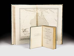
Voyage de découvertes aux terres Australes. Exécuté par ordre de sa Majesté l'Empereur et Roi, Sur les Corvettes le Géographe, la Naturaliste, et la Goelette le Casuarina, Pendant les Anées 1800, 1801, 1802, 1803 et 1804. [Historique] Rédigé en parti. - [THE FIRST PUBLISHED COMPLETE AND FULLY DETAILED MAPPING OF AUSTRALIA]
Vendeur : Lynge & Sřn ILAB-ABF, Copenhagen, Danemark
Membre d'association : ILAB
Evaluation du vendeur :
Paris, 1807-1816 (Historique) & 1815 + 1812 (Navigation & Geographie). 4to & folio. Three text-volumes in 4to and three atlas, two in small folios, one (Navigation & Géographie) in elephant folio. All bound in nice contemporary brown half calfs with gilt spines. The first four (i.e. Historique-section) are uniform. The Navigation & Géographie-part with some brownspotting, the text-voume has been re-enforced at front hinge and corners and extremities are worn. There's a repaired tear to one of the maps. The Historique-section is generally very nice, clean, and fresh. Vil. I of the atlas has a torn lower back hinge, but no loss. A very nice set in strictly contemporaru bindings, with the tissue-guards, and FULLY COMPLETE WITH ALL 40 ETHNOLOGICAL AND ZOOLOGICAL PLATES, MOSTLY COLOURED, ALL 46 MAPS, BOTH TABLES, AND THE FRONTISPIECE PORTRAIT. Historique: Text: XXXI, (1), 471 pp. + engraved frontispiece-portrait + two folded tables (4), XV, (1), 496, (2, -errata), III (contents) pp. Atlas: (vol. I, plates:) (6) pp. + 40 plates (numbered 2-41 NB. plate I of the the map-volume constitutes also nr. I of the plate-volume - as always (see also Ferguson) )" (vol. II, maps:) 6 pp. + 14 maps, two of which are folded.Navigation & Géographie: Text: XVI, 576, (2, -errata) pp. Atlas: (2) ff. + 32 maps, 25 of which are double-page, 7 single. Rare fully complete copy, with both the History- and Navigation&Geography- parts of one the most important and famous descriptions of Australia ever published. One of the maps included constitutes the first published map to show the entire South Australian coastline.In April 1802, the British navigator Matthew Flinders and his French counterpart Nicolas Baudin met at Encounter Bay. Both men had been sent out by their respective governments to chart and explore the unknown southern coast of Australia. Between them, Flinders and Baudin explored, mapped and named most of the 3,700 kilometres from Ceduna on the west coast to Robe in the southeast, known in 1802 as "the unknown coast". Although Flinders in fact beat Baudin to "the unknown coast", the famous French account was published first and thus constitutes not only the first full description of the continent of Australia, but also contains the first published complete and fully detailed map of Australia. "In October 1800, Nicolas Baudin commanded an expedition to the south seas to complete the French survey of the Australian coastline, and make scientific observations. The two ships, "Le Geographe and Le Naturaliste", arrived near Cape Leeuwin in May 1801. Following instructions issued in France, both ships sailed north along the western coast of the continent. After staying at Timor, the French then sailed south to survey Van Diemen's Land [Tasmania]. In following this itinerary, they missed the opportunity to be the first Europeans to survey the unknown southern coast. By early April 1802 Baudin in "Le Geographe" was in South Australian waters. He sailed westwards along the southern coastline, meeting Flinders at Encounter Bay, and continuing to Golfe de la Mauvaise [Gulf St Vincent] and Golfe de la Melomanie [Spencer Gulf], giving French names to many locations already named by Flinders. At Cape Adieu the survey was abandoned and Baudin sailed for Port Jackson where "Le Naturaliste" had already arrived. After wintering at Port Jackson, Baudin returned to the southern coast for a more detailed survey, and in January 1803 circumnavigated Ile Borda [Kangaroo Island]. While Baudin anchored at Nepean Bay, Freycinet and the geographer Boullanger explored the two gulfs in "Casuarina" - "Le Naturaliste" had been sent back to France with its scientific collections. By the end of February "Le Geographe" and "Casuarina" rendezvoused at King George Sound, and then explored the west and northwest coasts of 'New Holland', before heading home via Timor. Baudin died in 1803 on the homeward voyage, so publication of the account and charts of his voyage was undertaken by Francois Peron, the expedition's naturalist. The first volume of "Voyage de decouvertes aux Terres Australes" and Volume I of "Atlas", which included plates, was released in 1807. French place names were recorded for 'Terre Napoleon' west of Wilson's Promontory. As Peron died in 1810, cartographer Louis de Freycinet continued to edit the voyage's account, and in 1811 he published the second part of "Atlas", which featured the charts of the expedition, again recording French place names on 'Terre Napoleon.' The French expedition's charts were published in 1811 - three years before Flinders'. Freycinet's "Carte General de la Nouvelle Hollande" was therefore the first chart of Australia, bringing together the results of English and French surveys. The French charts are generally acknowledged as beautiful with their elaborate title cartouches with flora and fauna.In the end, claims of 'primacy' - or who was where first - were what mattered most to the authorities and to Flinders. With the French charts published first, with French names along the length of the South Australian coast, they laid a claim to that portion of the continent and called it "Terre Napoleon". When Flinders' charts were finally published in July 1814, he was scrupulous in honouring prior discoveries on the coast - hence 'Discovered by Nuyts 1627' and 'Discovered by Captn. Baudin 1802', which marked the western and eastern limits of his discoveries.It was not until the second edition of Voyage de decouvertes aux Terres Australes was published in 1824 that French place names were only recorded where the French had been the first to survey along the southern coast, mainly in the south-east and on the southern coast of Kangaroo Island, and Flinders' discoveries and place names were restored by the French authorities." (State Library of South Australia). Apart from the seminal importance to the maps and geographical information of this celebrated voyage, it is also famous for its ethnological surveys a.
-
De mirabilibus quae mundi.
Edité par Venice, Nicolaum Jenson, 1473. 1473, 1473
Vendeur : JF LETENNEUR LIVRES RARES, Saint Briac sur mer, France
Membre d'association : ILAB
Evaluation du vendeur :
Edition originale
1 vol. in-folio (285 x 182 mm) de : [1] f. bl. ; [2] ff. ; [1] f. ll. [63] ff. ; [1] f. bl. Texte imprimé sur 33 lignes. Emplacement des lettrines demeuré vierge. Annotations en marge ŕ l'encre brune ŕ chaque page. Exemplaire portant dans les marges les trous des punaises qui servaient aux premiers imprimeurs ŕ positionner les ff. sur la presse. Plein veau ancien (circa 1800), dos ŕ nerfs titré ŕ l'or, roulette sur les coupes. (Dos restauré, accidents aux coins, rares taches ou rousseurs). Provenance: Clifford Rattey (ex-libris, collection dispersée par Maggs); W.R.H. Jeudwine (ex-libris, sa vente Sotheby s Londres, 18 septembre 1984, lot 28); George Abrams (ex-libris, sa vente Sotheby s Londres, 16 novembre 1989, lot 118); Maria Ludovica Borromeo Arese et Massimiliano Favia del Core (ex-libris). Premičre édition de "De Mirabilibus quae mundi", uvre majeure du grammairien et compilateur romain Gaius Julius Solinus, dans lequel cet auteur, qui a vécu au IVe sičcle aprčs JC, résume sa vision du monde ŕ partir de diverses sources telles que Pline, Pomponius Mela, Cornelius Bocchus et d'autres. L ouvrage est rédigé sous la forme d'une collection de curiosités en histoire naturelle, géographie et histoire. La compilation de Solinus sur les merveilles du monde a connu une large diffusion ŕ travers le Moyen Âge. Des citations de l ouvrage par des auteurs tels qu'Augustine, Isidore et Bede attestent de son influence depuis une date précoce et un grand nombre de manuscrits du IXe sičcle et plus tardifs témoignent de sa popularité continue. Les récits les plus saisissants et pittoresques de l ouvrage ont été transférés presque dans leur intégralité sur les cartes médiévales. L ouvrage est une des sources possibles des plus anciennes cartes du monde conservées telle que la célčbre « Mappa mundi » d'Albi (produite au VIIIe sičcle, plus ancienne carte du monde conservée), ou encore la « mappa mundi » de la cathédrale de Hereford, datée de la fin du XIIIe sičcle. (C.R. Beazeley, The Dawn of Modern Geography, I, 1987, pp.247-272). Son agencement géographique dérive en grande partie de l'histoire naturelle de Pline et de la géographie de Mela. Elle revęt une importance mondiale, ŕ la fois pour les différents pays qu'elle représente dont elle est souvent la premičre représentation conservée, pour la mémoire du monde, et pour l'histoire de la cartographie mondiale. Quand parait l ouvrage, cela fait moins de 20 ans que la Bible de Gutenberg a été imprimée : c est l époque de la genčse de l imprimerie et de la typographie dont, l imprimeur de ce livre, Nicolas Jenson (1420 - 1480) est un des précurseurs. Jenson est un graveur qui commence sa carričre d imprimeur en 1458 lorsque Charles VII l envoie ŕ Mayence pour « secrčtement » s informer sur les techniques d impression de Gutenberg. Ŕ la suite de son séjour en Allemagne, Jenson exerça l essentiel de sa carričre d imprimeur ŕ Venise et mit au point des caractčres romains qui permettaient de minimiser la quantité d encre utilisée (trčs chčre ŕ l époque) tout en augmentant la lisibilité du texte. Grâce ŕ sa parfaite maîtrise des caractčres, les historiens de la typographie considčrent que ce sont les caractčres d imprimerie les plus parfaits jamais gravés. Jenson imprimera plus de 150 ouvrages au cours de sa vie et inspira le typographe du journal The Times ŕ créer sa célčbre police qu il baptisa New Roman en l honneur de Jenson. « De Mirabilia mundi » a également été imprimée ŕ Paris la męme année par Louis Simonel "Au Soufflet Vert", toutes les autres éditions sont postérieures. Exemplaire bien complet des 68 feuillets, dont 3 blancs. Édition d une extręme rareté : seuls 2 exemplaires sont passés en vente publique ces 50 derničres années, dont un en 2011 en mauvais état et incomplet de 2 des feuillets blancs. Notre exemplaire a conservé ses larges marges qui sont abondamment annotées par une main contemporaine. Dans ces marges, on trouve également les trous de punaises caractéristiques des débuts de l impression qui permettaient de guider la presse pour que les feuillets soient imprimés uniformément. Provenance: Clifford Rattey (ex-libris, collection dispersée par Maggs); W.R.H. Jeudwine (ex-libris, sa vente Sotheby s Londres, 18 septembre 1984, lot 28); George Abrams (ex-libris, sa vente Sotheby s Londres, 16 novembre 1989, lot 118); Maria Ludovica Borromeo Arese et Massimiliano Favia del Core (ex-libris) 1 vol. in-folio (285 x 182 mm) of : [1] f. bl. ; [2] ff. ; [1] f. ll. 63] ff ; [1] bl. f. ; [1] f. ll. Text printed on 33 lines. Location of the ornamental initial remained blank. Annotations in the margins in brown ink on each pages. Copy with the pin holes in the margins, which were used by the first printers to position the ff. on the press. Full calf binding circa 1800. First edition of "De mirabilibus quae mundi", major work of the grammarian and roman compiler gaius julius solinus, in which this author, who lived in the 4th century, summarizes his vision of the world from various sources such as pliny, pomponius mela, cornelius bocchus and others. The work is written in the form of a collection of curiosities in natural history, geography and history. The compilation of solinus on the wonders of the world was widely distributed throughout the middle ages. Quotes from the book by authors such as augustine, isidore and bede attest its influence from an early date and a large number of manuscripts from the ninth century and later attest its continued popularity. The most striking and picturesque accounts of the work were transferred almost in their entirety to medieval maps. The book is one of the possible sources of the oldest preserved maps of the world such as the famous "mappa mundi" of albi (produced in the 8th century, the oldest preserved map of the world), or even the "mappa mundi" of the cathedral. Of hereford, dated from the end of the 13th century. (c.r. Beazeley, the dawn of modern geography, i, 1987, pp. 247-272): its geographical arrang.
-
Geographicae Enarrationis, Libri Octo.
Edité par Fries / Ptolemy / Villanovanus (Servetus), 1541
Vendeur : Barry Lawrence Ruderman, La Jolla, CA, Etats-Unis
Membre d'association : ABAA ILAB
Evaluation du vendeur :
Carte
No Binding. Etat : VG. Fries / Ptolemy / Villanovanus (Servetus) / 1541 / Geographicae Enarrationis, Libri Octo. (Safe 1, 92392) Folio. 17th-century or early-18th-century mottled calf. Spine in seven compartments separated by raised bands. Elaborate gilt tooling in all but the second where a morocco title label reads "PTOLEM | GEOGRA[F]". (Overall rubbing. Minor wear and splitting at the hinges.) Front flyleaf with a 19th-century black ink stamp "LESECQ", possibly J.L.H. Le Secq, though not conforming to the stamps in L.1336. Housed in modern vellum over red cloth clamshell box. (One or two small wormholes scattered throughout. Faint marginal dampstain in places. Some minor faint stains. Woodcut on page 128 trimmed at the outside edge.) Collation: 149, [1] pages, 1 leaf; 50 woodcut maps, all but one double-page (Plansipheric world map bound between maps 23 and 24); [avi], [bvi], [cvi], [dvi], [evi], [fvi], [gvi], [hvi] (i.e., complete). A Handsome Example of the 1541 Edition of Fries Adaptation of Waldseemuller s Ptolemy. A very clean and attractive example of Fries 1541 edition of Ptolemy, including the first map in a Ptolemy atlas to name America and the suites of ancient and modern maps. The so-called Fries Ptolemy was first published in 1522 by Johann Koberger. Fries is generally thought to have edited the maps. The 1522 edition of Fries' work is very rare, suggesting that the work was not commercially successful. In 1525, an improved edition was issued, with a re-edit of the text by Willibald Pirckheimer, from the notes of Johannes Regiomontanus. After Gr ninger died in 1531, the business was continued by his son Christoph, who seems to have sold the materials for the Ptolemy to two Lyon publishers, the brothers Melchior and Gaspar Trechsel, who published a joint edition in 1535, before Gaspar Trechsel published an edition in his own right in 1541. Fries was initially a physician, working in various places in the Alsace region and Switzerland before settling in Strasbourg around 1519. He was known for his medical writings and met the Strasbourg printer and publisher Johann Gr ninger, who was responsible for printing several of Waldseemuller's maps and supervising the cutting of the maps for the 1513 edition of Ptolemy edited by the St. Die group of scholars, including Walter Lud, Martin Ringmann, and Martin Waldseemuller. In addition to the book's complement of maps, it includes a full-page armillary sphere showing the inhabited earth by Albrecht D rer (Meder 262). The Ancient Maps Fries' work follows the typical cartographic tradition in Europe in the 15th and early 16th centuries in that it reproduces the maps of Claudius Ptolemy, the famous Greco-Roman mathematician, astronomer, geographer who was active in the 2nd Century AD. The Modern Maps Generally, the maps in the modern section are reduced copies by Lorenz Fries of the modern maps that appeared in Martin Waldseemuller s Ptolemy of 1513, Geographie Opus Novissima. To that group, Fries has added a map of Southeast Asia, East Asia, China, and Japan, and a navigational map of the world. Map.
-
Die oberen Nil-Länder. Volkstypen und Landschaften. Dargestellt in 160 Photographien. Nach der Natur aufgenommen von R. Buchta.
Vendeur : Antiquariat Kainbacher, Baden bei Wien, Autriche
Membre d'association : ILAB VDAO
Evaluation du vendeur :
Berlin, Stiehm 1881. Daraus: 54 Original-Fotografien auf 29 Blatt. Trägerkartons mit Eckabrissen, Fotos in guter Erhaltung, Tafeln lose in neuer Mappe. Sehr selten! ? Buchta gilt als Pionier der Fotografie im Sudan. Seine ethnologischen Aufnahmen der Völker vor allem des Südsudan sind einzigartige Dokumente. Die Fotos zeigen beeindruckende Aufnahmen und Portraits von Häuptlingen und Angehörigen folgender Völker: Bischarin, Schukurieh, Schilluck, Bari, Madi, Schuli, Umiro, Nakatschupi und Kagaja, Magungo, Lango, Makraka, Abukaja, Niam-Niam, Monbuttu, Akka, Moru. 1870 kam der Österreicher Richard Buchta (1845-1894) nach Kairo und arbeitete als Straßenfotograf. 1877 wurde er vom in ägyptischen Diensten stehenden, italienischen Gouverneur der Provinz Bahr el-Ghazal (Gazellenfluß) für fotografische Arbeiten im Sudan angeworben. 1878 begab er sich von Khartum nilaufwärts über Lado, wo ihn Emin Pascha (Gouverneur der Äquatorialprovinzen) aufnahm, nach Dufile, von wo er bis zum Albert-See und Uganda vordrang. In der Folge schloß er sich einer Expedition Emin Paschas an, die ins Königreich Bunyoro (im heutigen Uganda), südlich des Victoria-Sees, führte. Von der Reise mit reicher fotografischer Ausbeute zurückgekehrt, vermerkte Buchta: "Die Reise bot mir viele Genüsse, besonders durch die großartigen Vegetations-Scenerien in Unyoro, die an kraftstrotzender Üppigkeit Alles überbieten, was sich selbst eine kühne, weit gehende Phantasie vorstellen kann". Die auf dieser Reise aufgenommenen Fotografien und Zeichnungen wurden unter dem Titel "Die oberen Nilländer. Volkstypen und Landschaften", 1881 herausgegeben. In Petermann's Geographischen Mitteilungen vermerkte ein unbekannter Autor 1880: "Von R. Buchta, der unlängst von seiner Reise nach Uganda in die Heimath zurückgekehrt ist, liegt uns eine Reihe von Photographien vor, schöne und höchst interessante Blätter, über deren Ausführung man staunen muss, wenn man die schwierigen Verhältnisse kennt, unter denen sie aufgenommen wurden. Die Murchison-Fälle beim Victoria Nyanza, Ansichten des Nil im Bari Lande, des Mwutan, des Djebel Redjaf & c., alsdann Niam-niams, Monbuttu-, Bari- und Dinka-Neger und andere Typen der Bevölkerung am oberen Nil treten uns hier in frappanter Naturtreue entgegen". ? Paulitschke 120; Henze I,388f; Kainbacher 65.
-
Stereo-Fotografien von der Reise S.M.S. Hertha nach Ost-Asien und den Südsee-Inseln. 1874-1877.
Vendeur : Antiquariat Kainbacher, Baden bei Wien, Autriche
Membre d'association : ILAB VDAO
Evaluation du vendeur :
O.O.1877. 97 (davon 3 doppelte) Original-Stereofotografien. Die Albuminabzüge sind sehr kontrastreich und als gegen das Licht zu haltende Tissue-Bilder angefertigt. Nicht auf Pappe, sondern in Papprahmen montiert. Ein Abzug mit repariertem Einriß, alle anderen in sehr gutem Zustand. Dazu: Original-Stereobetrachter der Firma Smith, Beck & Beck London (ca.1860), in einem Original-Aufbewahrungskabinett aus Walnussholz (darinnen Platz für die Stereophotographien). Neben dem sehr seltenen Foto-Album von Riemer: ?Tagebuchs-Auszug betreffend die Reise S.M.S. Hertha nach Ost-Asien und den Südsee-Inseln. 1874-1877. Teplitz 1878.? Veröffentlichte Riemer auch sehr frühe Stereo-Photographien. Dazu hatte er auf seiner Reise auch eine Zweiobjektivkamera mit. Bislang ist bekannt (nach Bennett, Lüthje und Mückler), daß die Stereophotographie-Serie erst bei Liersch dann bei Stiehm (beide Berlin) erschienen ist. Beide Serien sind selten und man findet vereinzelte Photographien. Alle sind auf orangem Karton montiert. Daneben findet sich im Deutschen Historischen Museum auch eine Serien von Glass-Stereos von Riemer. Um 1900 hat dann die Neue Photographische Gesellschaft in Berlin Steglitz die Abzüge neu aufgelegt, z.T. mit der irreführenden Angabe ?Originalaufnahme von Dr. Kurt Boeck? (Boeck ist ein bekannter Himalaya-Forscher und hat mit diesen Aufnahmen und dieser Reise absolut nichts zu tun !!). Die hier vorliegende Serie ist in ihrer Machart (alle in schwarz geprägter Pappe, wie diese für die frühen Stereos charakteristisch sind) die wohl älteste Serie und bisher unbekannt. Motive: Die 97 Photographien zeigen folgende Motive: Leben an Bord der SMS Hertha oder Militärische Szenen: 24 Stereos, incl. 2 Selbstportraits von Riemer. Südsee (Tonga, Samoa, Philippinen, Mikronesien, etc.: 60 Stereos, incl. 1 Selbstportrait von Riemer auf Tonga Island. Singapore: 3 Stereos. Wladiwostok: 2 Stereos. Rio de Janeiro: 4 Stereos. Unbekannte Orte: 4 Stereos. - Gustav Adolph Riemer (1842-1899) arbeitete auf mehreren Schiffen der preussischen Marine als Zahlmeister. Mit der SMS Hertha bereiste er Madeira, Brasilien, Singapur, Borneo, Sulu-Islands, Philippinen, China (Hongkong, Kanton, Amoy), Japan, Bonin, Mikronesien: Marianen (Guam), Karolinen und Palau, Ost-Sibirien, Samoa, Tonga, Neu Seeland und Australien. Riemer war als Photograph Autodidakt. Auf dieser Reise verwendete er eine großformatige Holzkamera mit Balgenauszug und einem Petzval Objektiv. Die Belichtungszeit bei Aufnahmen unter freiem Himmel betrug mehrere Sekunden. Weiters hatte Riemer wahrscheinlich zwei Reisekameras und für die Stereophotographie eine Zweiobjektivkamera. Commandant dieser Reise war Corvetten-Capitain Eduard Knorr, der zuvor auf dem Kanonenbott ?Meteor? seinen Dienst absolvierte. ?Das Schiff ?S.M.S. Hertha hatte seine Indienststellung am 1. November 1865. Das Schiff nahm 1866 am preußisch-österreichischen Krieg teil, fuhr 1867 im Mittelmeer mehrere Einsätze, nahm an der Eröffnung des Suezkanals teil (1869) und fuhr von dort nach Singapur (1870), um die Seeräuberei an der chinesischen Küste zu bekämpfen und Japan einen Besuch abzustatten. Danach folgten zahlreiche Einsätze vor der chinesischen und japanischen Küste in den Jahren 1870-1872. Anschließend kehrte es nach Deutschland zurück und diente eine zeitlang als Schulschiff. Am 28. Oktober 1874 startete die ?S.M.S. Hertha zu einer Weltumseglung, die das Schiff wieder nach Ostasien brachte. Von Yokohama aus wurden im März 1876 die Palau-Inseln, die Marianen Inseln und die Karolinen besucht, um deren von den Spaniern zugesicherte Zugänglichkeit für den Handel zu überprüfen. Der Zahlmeister Gustav Adolph Riemer machte dabei in Mikronesien zahlreiche photographische Aufnahmen von hohem ethnographischen Wert. Die mikronesischen Inseln standen damals noch nicht unter formeller deutscher Kolonialverwaltung. Unter Kommando von Kapitän zur See Eduard von Knorr wurden auf Weisung des Reichskanzlers gemeinsam mit den kaiserlichen Konsuln Meistbegünstigungsverträge mit den Samoa- und Tonga-Inseln abgeschlossen. Zu diesem Zweck traf die Hertha Anfang Oktober 1876 in Apia ein. Zusammen mit Konsul Theodor Weber wurde mit den beiden sich bekämpfenden einheimischen Parteien in Samoa Verhandlungen geführt. Ein Aufenthalt in Nuku?alofa, Tonga-Inseln, führte zum Abschluss eines Handelsvertrages sowie einer Abmachung zur Einrichtung einer Kohlestation für Kriegsschiffe auf Taulanga am 1. November 1876 (ratifiziert am 31. Oktober 1877) Nach Rückkehr nach Apia um den 10. Dezember 1876 wurden die dortigen Verhandlungen weitergeführt. Bei einem Aufenthalt in Auckland am 24. Dezember 1876 erhielt das Schiff seinen Heimreisebefehl. Ein nochmaliger Zwischenhalt in Apia erbrachte schließlich eine Vereinbarung mit den samoanischen Konfliktparteien, die Siedlungsgebiete der Ausländer bei Kämpfen zu schonen. Über Auckland, Australien und den Suez-Kanal traf die Hertha am 27. Juli 1877 in Kiel ein. Anschließend war das Schiff im Mittelmeer im Einsatz sowie als Seekadettenschiff in Verwendung sowie als Teilnehmer an der Weltausstellung im australischen Melbourne 1881.? (Hermann Mückler).
-
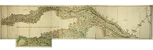
The Drau River from Lienz in East Tirol to Zegedin in Hungary
Edité par Paris: ca 1762-1767, 1767
Vendeur : Arader Galleries - AraderNYC, New York, NY, Etats-Unis
Evaluation du vendeur :
BELLIN, Jacques-Nicolas (1703-1772). The Drau River from Lienz in East Tirol to Zegedin in Hungary. Paris: ca 1762-1767 3 sheets joined, and a short extension to the lower margin (sheet size: 13 x 64 4/8 inches; 12 2/8 x 57 inches to the neat line). EXCEPTIONALLY FINE ORIGINAL MANUSCRIPT MAP of the course of the Drau (Drava) River from Lienz in East Tirol to Zegedin (Szegedin) in Hungary, showing a potential canal that might join it to the Theiss (Tisza) River between Vukovar and Zegedin, the upper reaches of the Sau (Sava) and Kulpa (Kolpa) Rivers and the shores of the Adriatic at Trieste and Fiume (Rijeka), with a lengthy manuscript legend in the left-hand margin, probably in Bellin's hand (old vertical folds with some discreet repairs to verso). Provenance: early manuscript archival notes dated September 17th 1767 and 2nd November 1780 on the verso A MAGNIFICENT AND IMPORTANT MAP of the vast area through which the Drava River, an important tributary of the Danube, flows. The western edge of the map shows the Drava at Lienz in East Tirol, near its source in the Italian South Tyrol, at the drainage divide of Toblach (Dobbiaco) in the Puster Valley. From there it flows eastwards through Carinthia in Austria into Slovenia and then southeast, passing through Croatia and forming most of the border between Croatia and Hungary, before it joining the Danube near Osijek. This exceptional hydrographical map covers parts of Hungary, Slovenia, Carniola, Carinthia, Northern Italy, and East Tyrol. It shows several hundred towns and all existing and planned canals and watercourses in the area at the time of drafting. In the legend to the left of the map, in manuscript identical to that already associated with Bellin (see the manuscript Index of Bellin's "Cartes Marines". Paris: N. Bellin, 1737-1754 in the Arader Galleries library), the author of this map presents as his sources for this present map the anonymous cartographer of "the least deficient maps" of Carinthia and Hungary, but also his own works. The artist's self-assured reference to his own mapping of the Trieste and Fiume coastlines in 1756 provides further evidence of his identity as that of Bellin. In 1756, the French cartographer and engineer Jacques-Nicolas Bellin published his "Hydrographie françoise", mapping all oceans and coastlines of the world. In addition, it seems unlikely that a military cartographer or a geographer working on the early Josephinic ordnance surveys would dare to comment on the inadequate mapping of Carinthia and Hungary and recommend the famous astronomer Maximilian Hell (1720-92) as the man best suited to the task. Bellin's interest in creating a system of canals across newly industrialized Europe can be established from 1762 when he was the principal contributor to Diderot's "Encyclopédie" on the subject. The earliest date on the verso of the current map is late 1767, establishing a potential period for the creation of this map at between 1762 and 1767. Bellin was the most significant and influential chart publisher in eighteenth-century France. He was appointed chief cartographer and hydrographer to the French Navy in 1721, and "ingénier hydrographe" to the French navy's Dépôt des cartes et plans de la Marine in August 1741. Bellin was also a member of the Académie de Marine and of the Royal Society of London. During his 50-year career, Bellin published a number of atlases, including 'Hydrographie française' (1753), 'Carte de l'Amerique septentrionale' (1755), 'Petit Atlas Maritime' (1764), and 'Nouvelle méthode pour apprendre la géographie' (1769). About twenty years later, cartographer Francois Jospeh Maire based in Vienna, describing himself as a hydrographer and military Engineer, published his own magnificent map "Carte Hydrographique des Etats de la Maison d'Autriche en deca du Rhin." in 1786, giving a full overview of the water transportation links across the Austiran Empire, covering some of the same area from the Adriatic Sea nort.
-
TABULA TERRE NOVE [THE ADMIRAL'S MAP]
Edité par Johann Schott, [Strassburg, 1513
Vendeur : William Reese Company - Americana, New Haven, CT, Etats-Unis
Membre d'association : ABAA ESA ILAB SNEAB
Evaluation du vendeur :
Woodblock map on two joined sheets. Overall joined sheet size: 18 1/4 x 20 3/4 inches. Evidence of previous mounting on outer margins (not touching text), light even tanning. Diagonal tear in lower left corner, with loss of paper (not affecting text). Very good. An excellent copy of the earliest obtainable printed map focusing on the western hemisphere. It is preceded only by Peter Martyr's map of the Spanish Main (Seville, 1511), and Johannes Stobnicza's 1512 map. This was the most important map featured in Johann Schott's edition of Claudius Ptolemy's GEOGRAPHIE OPUS NOVISSIMA TRADUCTIONE E GRECORUM ARCHETYPIS CASTIGATISSIME PRESSUM, the first modern atlas. This map depicts the eastern coast of North and South America in a continuous line from the northern latitude of 55° to Rio de Cananor at the southern latitude of 35° (approximately the Rio de la Plata), with about sixty places named. The notably blank interior of the continent is appropriately labeled "Terra Incognita." In the Caribbean, Cuba is identified as "Isabella," after Queen Isabella of Spain; Hispaniola is "Spagnolla"; and Puerto Rico is "Boriguem." Jamaica (Jamaiqua) is also featured, together with several smaller islands in the Caribbean and Bahamian archipelagos. North America is somewhat compressed, and includes a river named Caninor, quite possibly the St. Lawrence River. About twenty places are identified on the North American coastline, drawn primarily from Portuguese sources, including the Cantino Portolano PLANISPHERE (1502) and the Caverio map of the world (ca. 1505). The depiction of the Floridian peninsula and the curve of the coast of the Gulf of Mexico suggests that Waldseemüller had access to reports from as-yet unrecorded voyages. The first recorded European contact with Florida was by Ponce de Léon's voyage, which was in 1513, the same year this map was printed; the first mapping of the Gulf was done during Alonso Álvarez de Pineda's voyage in 1517-19. The text printed near the northern coast of South America explains that the land and adjacent islands were discovered by Columbus: "Hec terra cum adiacentib[us] insulis inuenta est per Columbu[m] ianuensem ex mandato Regis Castelle" ("This land with its adjacent islands was discovered by Columbus, sent by the king of Castile"). Some scholars have suggested that this was Waldseemüller's effort to correct his 1507 map, which credited Amerigo Vespucci with the discovery of America. Adding to further debate, Waldseemüller notes the source of this map as "the Admiral," with some scholars asserting this must be Columbus, and others arguing that it refers to Amerigo Vespucci. Recent scholarship suggests that it may be from an inscription on the Caverio map noted above. Regardless, this map is central to the cartographic history of the Americas. Excepting the smaller edition of this map published by Laurent Fries in Lyon (1522), it was not until 1534 that another large-scale map of the Americas was published, by Giovanni Battista Ramusio. Martin Waldseemüller (ca.1470-ca.1522) was one of the leading cartographers during the first great period of global exploration by European powers. He studied at the University of Freiburg, and then joined a group of humanist scholars based at the Abbey of St. Dié in Alsace. Waldseemüller was inspired by Vespucci's work MUNDUS NOVUS, which argued for the first time that the "New World" was a distinct landmass. Accordingly, in 1507, Waldseemüller published the first map, printed or in manuscript, to depict a separate Western Hemisphere, with the Pacific as a separate ocean (UNIVERSALIS COSMOGRAPHIA SECUNDUM PTHOLOMAEI TRADITIONEM.). This map clearly portrays the Americas as "the Fourth Part of the World," with a western coastline, showing it to be completely separate from Asia. This map was perhaps a bit too controversial at the time, and this TABULA TERRE NOVE, while still revolutionary, may have been his attempt to scale back the claims in the 1507 map. Here, Waldseemüller does not show a western coastline, leaving the possibility of the Americas as a separate landmass to be ambiguous. The label "America" is also absent, and credit for discovery is given solely to Columbus. In spite of this, "America" was utilized by Mercator in 1538, and from then on was the name of the New World. This striking map is a foundational item in the history of cartography, and is uncommon to find separate from Schott's Ptolemy. BARLOW SALE 2037. EUROPEAN AMERICANA 513/6. HARRISSE 74. JCB (3)I:57-58. SABIN 66478. SHIRLEY, WORLD MAPS 34. STREETER SALE 6. PHILLIPS, ATLASES 359. WORLD ENCOMPASSED 56. Bagrow, HISTORY OF CARTOGRAPHY, p.126. PANZER VI:283. PROCTOR 10271. SHIRLEY, BRITISH ISLES 10. Stevens, PTOLEMY'S GEOGRAPHY (1908), p.44.
-
Homann, J.B.: Atlas Novus: Grosser Atlas uber die gantze Welt (.). Nürnberg, Homännische Erben, 1737
Edité par Homännische Erben, Nürnberg, 1737
Carte
Hardcover. Etat : Gut bis sehr gut. Homann, J.B. Atlas Novus: Großer Atlas uber die ganze Welt.samt einer kurzen Einleitung zur Geographie worinnen die Erde. (.). Nürnberg, Homännische Erben, 1737, (4), 40 S., 103 Doppel-S. (Falz) teilweise handkol. gestochene Karten (1x 2 Blatt Karten), 4 handkol., gest. Schlachtpläne (gezählt als 2) und 2 Tafeln als Doppel-S. und eine Tafel, handkol. gest. Titel, Grossfolio. Zusätzlich (wie im Index genannt): Idem. Atlas Methodicus (.). Idem, n. Publ., 1719, (15) S. 18 handkol. gest. Karten und 1 ill. (Frontisp.), Holzschnitt-Druckerzeichen. - Alle Karten sehr schön. "Extractum Privilegii" (=d.) wie im Index genannt, fehlt. Buchrücken mit Kalbsleder restauriert, ebenso kleine Fehlstellen an den Kanten hinterlegt.Selten so vollständiger Atlas mit allen Karten in so guter Qualität mit nur minimalen Bräunungen. Inklusive: 3 Weltkarten (Doppel-Halbkugel mit Himmelskugeln und / oder zusätzlichen halbkugelförmigen Karten); 4 Karten der Kontinente Europa, Asien, Afrika und Nord- und Südamerika und 4 fast identische Karten, aber mit unterschiedlicher Färbung, die die religiöse Vielfalt der Kontinente hervorhebt; Karten verschiedener Länder / Regionen weltweit, inkl. 3 Karten von Amerika ("Virginia Marylandia und Carolina", "Nova Anglia" und "Mississipi"), 2 Karten von Russland ("Russiae Magnae" und "Imperii Russici"), mehrere Karten mit detaillierten Stadtansichten / Vor allem von Aggerhus (Blick auf eine Bergmine), London und Stockholm (Stadtansichten) und Landkarten von Spanien, Grossbritannien, Italien, Frankreich, Niederlande, Finnland, Ungarn, Griechenland, Rumänien, Dänemark, Mexiko, Chile, Peru , Litauen (2-Blatt-Karte), das Po-Gebiet in Italien (Faltkarte) und 4 zusätzliche Karten von Frankreich (nicht im Index genannt): "Gallia Postarvm", "Gubernatio Generalis Langvedociae", "Normannia" und "Gouvernement .und viele weitere Karten, siehe Register. Aufgrund der schlechten Lichtverhältnisse sind die Bilder leider etwas gelblastig und von schlechter Auflösung. Weitere Bilder gerne auf Anfrage. Homann, J.B. Atlas Novus: Grosser Atlas uber die gantze Welt (.). Nürnberg, Homännische Erben, 1737, (4),40p., 103 double-p. (fold.) partly handcol. engr. maps (1x 2 sheet map), 4 handcol. engr. battle-plans (counted as 2) and 2 double-p. plates and 1 table, handcol. engr. title, title-p. ill., contemp. gilt hcalf w. letterpiece, large folio. - BOUND WITH (as called for in index): Idem. Atlas Methodicus (.). Idem, n. publ., 1719, (15)p., 18 handcol. engr. maps and 1 ill. (frontisp.), woodcut printer's mark. - All maps fine. Lacking the textleaf "Extractum Privilegii" as called for in the index. Bookplate on upper pastedown; final 20 lvs. (sl.) wormholed in right blank margin; occas. sl. foxed/ browned; title-p. w. sm. tear; first lvs. (sl.) frayed. Covers (heavily) worn/ chafed and dam. along edges. = Rare extended copy with beautifully decorated maps. Including: 3 worldmaps (double hemisphere with celestial spheres and/or additional hemispheric maps); 4 maps of the continents Europe, Asia, Africa and North and South America together, and 4 almost identical maps but with different colouring highlighting the religious diversity around the contintents; maps of various countries/ regions around the world, incl. 3 maps of America (''Virginia Marylandia et Carolina", "Nova Anglia" and "Mississipi"), 2 maps of Russia ("Russiae Magnae" and "Imperii Russici"), several maps w. detailed cityviews/ landscapes/ plans, most notably of Aggerhus (view of a mountain mine), London and Stockholm (cityviews) and maps of i.a. Spain, Great-Brittain, Italy, France, The Netherlands, Finland, Hungary, Greece, Romania, Denmark, Mexico, Chili, Peru, Lithuania (2 sheet map), the Po river area (fold. map) and 4 extra maps of France (not called for in the index): "Gallia Postarvm", "Gubernatio Generalis Langvedociae", "Normannia" and "Gouvernement General de Picardie".
-
Geographischer und Physischer Atlas von Neu-Spanien. gegründet auf astronom: trigonom: und Barometer Messunden [old ink mss.].
Date d'édition : 1812
Vendeur : Altea Antique Maps, London, Royaume-Uni
Membre d'association : ABA ILAB PBFA
Evaluation du vendeur :
Edition originale
Tubingen bey J.C. Cotta, 1810 [old ink mss.]. Folio, contemporary half calf with marbled boards, maroon morocco gilt title label on front board; title in old ink mss on front endpaper. Plates numbered 1-20 (6-8 on one sheet): a two-sheet folding map, 4 double-page maps, 6 single page maps, 4 double-page cross sections with hand colour, 2 sepia aquatint views of volcanos, 1 engraved table. With the bookplate of Gustav Parthey. Two Prussian passports for Parthey, dated 1858 & 1867, loosely inserted. Binding scuffed, contents clean and in very good condition. The complete set of plates from Humboldt's famous 'Atlas Géographique et Physique du Royaume de la Nouvelle-Espagne', the plate volume of his 'Essai politique sur le royaume de la Nouvelle-Espagne'. It has a German translation of the title in manuscript with the name of Cotta, publisher of the true first edition of the 'Essai politique', which was suppressed by Humboldt himself because of a dedication to Charles IV of Spain, who had been forced to abdicate by Napoleon in 1808. The 'Essai politique' was an account of Humboldt's expedition to Mexico in 1803-4 with botanist Aimé Bonpland. During the trip he accurately measured the longitude of Acapulco (plate 18), drew the two-sheet 'Carte Generale du Royaume de la Nouvelle Espagne' the most accurate map of Mexico (and Texas) and the four-sheet profile of Mexico, the first complete profile of any country. The bookplate is of the library of Gustav Friedrich Konstantin Parthey (1798-1872), art historian, owner of the Nicolaische Buchhandlung in Berlin, and correspondent of Humboldt's. He wrote an extensive transcript of Humboldt's 'Kosmos' lectures at the Berlin University, 'Vorlesungen uber physikalische Geographie', 1827-1828. Parthey also compiled a catalogue raisonné of the etchings of Wenceslaus Hollar in 1853, a reference still in use today. He joined Humboldt as a member of the Prussian Academy of Sciences in 1857.
-
Voyage en Scandinavie, en Laponie, au Spitzberg et aux Feröe pendant les années 1838-1840 sur la corvette La Recherche, commandée par M. Fabvre. Publiés par ordre du Roi sous la direction de M. Paul Gaimard.
Vendeur : Antiquariaat Junk, Amsterdam, Pays-Bas
Membre d'association : ILAB NVVA
Evaluation du vendeur :
Paris, A. Bertrand, (1842-1855). 17 text-volumes (bound in 16). 8vo (220 x 140mm). & 5 atlases (bound in 3), with 449 (76 hand-coloured) plates. Folio (523 x 360mm). Contemporary red half calf, richly gilt decorated spines with gilt lettering and red boards & 1 atlas differently bound in contemporary dark brown calf, richly gilt decorated spine with gilt lettering and dark green boards. A complete set of the most important scientific expedition to Scandinavia, which is composed as follows:Text-volumes: Relation du Voyage, by X. Marmier, 2 volumes; Météorologie, by V. Lottin, A. Bravais and others, 3 volumes; Magnétisme terrestre, by V. Lottin, A. Bravais and others, 3 volumes; Aurores boréales, by V. Lottin, A Bravais and others, 1 volume; Géologie, by E. Robert, 2 volumes (bound in 1); Géologie, by J. Durocher, 1 volume; Géographie physique, Botanique et Physiologie, by C. Martins, J. Vahl and others, 2 volumes; Astronomie et hydrographie, by V. Lottin, A. Bravais and others, 1 volume; Littérature scandinave, by X. Marmier, 1 volume; Histoire de la Scandinavie, by X. Marmier, 1 volume.Atlases: Atlas Pittoresque, with 311 lithographed plates; Physique, with 31 plates and maps; Géologie (by Durocher), with 11 plates (on 12 sheets); Géologie (by Robert), with 20 plates; Zoologie, with 76 hand-coloured engraved plates.The fine plates of the 'Atlas Pittoresque'' are by Mayer, Lauvergne and Giraud. Plates 1-27 concern Denmark, plates 28-36 Faroe Islands, plates 37-39 Hamburg, plates 40-127 Norway, plates 128-154 Spitzbergen, plates 155-171 Lapland, plates 172-220 Sweden, plates 221-251 Finland, plates 252-287 Russia, plates 288-310 Lithuania, Poland, etc. There is an extra plate 103A, not called for in the index of plates.The 'Atlas de Physique' shows among other subjects, 15 splendid as well as dramatic views of the northern lights, the most dramatic is an aurora observed at Bossekol, Finnmark (northern Norway), on Jan 21, 1839. The 'Atlas de Géologie' has impressive plates of glaciers, a particularly fine one is 'Vue répresentant l'enceinte de montagnes et des glaciers qui entourne la baie de la Madeleine (Spitzbergen)'.The 76 hand-coloured engraved plates of the Zoological Atlas are composed as follows: Birds. 6 plates (unnumbered) - Fishes. 20 plates (numbered 1, 4-9, 11-22 & 16bis) - Crustacea. 40 plates (numbered 1-11, 13-20, 22-31, 35-43 & 5a, 11b) - Vermes, Coelenterata, Protozoa. 10 plates (numbered C-M). The text to this atlas remained unpublished as well as the printed title to the atlas.Joseph Paul Gaimard served as naturalist on four major scientific voyages. His first voyage was a circumnavigation of the globe on the 'Uranie' 1817-1820 led by de Freycinet, the second voyage was the search for La Perouse on the 'Astrolabe', 1826-29. In 1835-6 he was on board the 'Recherche' as the scientific leader to an expedition to Iceland and Greenland. And finally in 1838-40 Gaimard was the leader of a scientific expedition, see the above offered copy, on the 'Recherche' to Northern Norway, Lapland, Spitzbergen, and the Faroe Islands."The commission was instructed to investigate and report on all phases of science, on history, and social conditions of the northern countries mentioned in the title. The Scandinavian countries, Sweden and Norway, and the Spitsbergen archipelago were visited during the summer of 1838 and 1839, and in the summer of 1840 a trip was made to Archangel" (Arctic Bibl.). "Born and educated in the French Midi, Paul Gaimard became one of the most widely traveled naturalists in the history of scientific exploration serving as director of the Scientific Commission for the North, he conducted extensive explorations in Lapland and on Spitzbergen and the Faroes. With the latter journey (1838-1840) Gaimard's frenetic, albeit highly productive, wandering apparently came to an end" (DSB V, p. 225).Some occasional browning and foxing, generally a fine and complete set.Provenance: Bookplate of Schloss Brunsee, the library of Marie Caroline Duchess of Berry, daughter of King Francis I of Naples-Sicily and daughter-in-law of King Charles X of France. All volumes have the bookplate of Schloss Brunsee.B.M.(N.H.) II, pp. 607-608,
-
I. Geographiae libri octo, recognitiam diligenter. [II. Galliae Tabule Geographicae. Belgii Inferiores Geographicae Tabule].
Edité par Cologne, Gottfried von Kempen, 1584 / Duisburg, [1585-1602]. 1584, 1602
Vendeur : JF LETENNEUR LIVRES RARES, Saint Briac sur mer, France
Membre d'association : ILAB
Evaluation du vendeur :
Edition originale
3 parties en 1 vol in-folio (410 x 280 mm) de: [2] ff. (titre gravé et enluminé et feuillet préliminaire) ; 106 pp. (nombreux schémas dans le texte) ; [16] ff. (index, 1 tableau sur pleine page) ; [5] ff. (f. blanc, titre, privilčge et schéma gravé sur pleine page) ; 27 cartes sur double page en beaux coloris d'époque avec description de chacune au dos ; 1 carte dépliante avec description ; [15] ff. (index) ; [10] ff. (titre gravé, privilčge, avis au lecteur et index) ; 23 cartes sur double page avec description de chacune au dos ; 1 carte ŕ pleine page avec description. (Rares traces de mouillures, corps d'ouvrage frais). Plein veau XVIIe, dos ŕ nerfs orné, titre de maroquin rouge, roulette dorée sur les coupes, tranches jaspées rouges. (Discrčtes restaurations aux coiffes et aux coins) Premičre édition avec la traduction de la géographie de Ptolémée par Pirckheimer, éditée par Arnold Mylius, exemplaire avec 28 cartes en superbes coloris d époque. Gerard Mercator (1512-1594), surnommé par Ortelius "le Ptolémée de notre temps", gravait ces plaques de cuivre dans le cadre d'une cosmographie qu'il comptait publier en cinq volumes. Le temps et l'effort mis par Mercator dans sa révision de Geographia de Ptolémée faisaient partie d'un grand projet qui occupa la plus grande partie de sa vie. Mercator avait pour projet de produire un ouvrage donnant la géographie et l histoire des mondes antique et moderne. Sa carte générale Ptolémaďque est l'une des plus belles jamais produite. Les plaques de Mercator étaient si parfaites que 7 autres éditions en seront tirées. Adams P-2232; Sabin 66490; Koeman Me2; Shirley 139. 3 parts in 1 vol in-folio of: [2] ff. ; 106 pp. ; [16] ff. ; [5] ff. ; 27 maps on double page in beautiful period colors with description of each one on the back; 1 folding card with description; [15] ff. ; [10] ff. ; 23 maps on double page with description of each one on the back; 1 full-page map with description. 17th century calf, decorated ribbed spine, red morocco title, gilt roulette on the cuts, red marbled edges. (Discreet restorations to the caps and corners). First edition, with the translation of the geography of Ptolemy by Pirckheimer, edited by Arnold Mylius, copy with the 27 maps in beautiful contemporary colors. Gerard Mercator (1512-1594), named by Ortelius "the Ptolemy of our time", engraved these copper-plates as part of a cosmography that he intended to publish in five volumes. Mercator's time and effort in revising Ptolemy's Geographia was part of a larger project that occupied most of his life. Mercator's plan was to produce a work on the geography and history of the ancient and modern worlds. His general Ptolemaic map is one of the most beautiful ever produced. The plates of Mercator were so perfect that 7 other editions were made with them. [bound with Mecator Galliae Tabule Geographicae. 24 engraved maps].
-
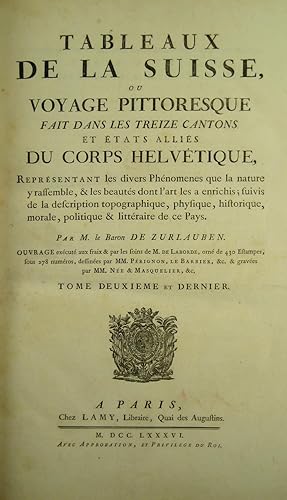
Tableaux topographiques, pittoresques, physiques, historiques, moraux, politiques, littéraires, de la Suisse (vol. I); (and:) Tableaux de la Suisse ou voyage pittoresque fait dans les treize cantons et états alliés du Corps hélvetique; (followed by) Table analytique et raisonnée des Tableaux de la Suisse . par (F.A.) Quétant (vol. II); Tableaux de la Suisse, ou Voyage pittoresque fait dans les treize cantons et états alliés du Corps Helvétique (vol. 3: plates).
Edité par Paris, Clousier, Lamy, 1780
Vendeur : Hellmut Schumann Antiquariat, Zurich, Suisse
Membre d'association : ILAB VEBUKU
Evaluation du vendeur :
Edition originale Signé
With frontispiece after Moreau le jeune engr. by Née, engr. title with view by Née, and 430 copper engravings numbered 1-278. Large folio. 19th century red morocco, spines with gilt lettering, gilt borders on covers, gilt inner dentelles, t.e.g., signed Koehler on spine of vol. I (somewhat rubbed, a few spots). Exlibris Christopher Tynor, Stoke Rochford Library, Lincolnshire. Paris, Clousier, Lamy, 1780-88. First edition. A nice copy of this precious and classic work on Switzerland, with fine views drawn by Bertaux, Besson, Brandoin, Châtelet, S.H. Grimm, Le Barbier, Pérignon, a.o., and engraved by Née, Niquet, Alix, de Longueil, Dequevauviller, Droyer, Borguet, Masquelier, Choffard, Aveline, a.o. Many leaves have two or more engravings, the numbering is sometimes repeated, sometimes there are several numbers on one leaf. There are 7 double-page maps (included in the numbering) by Clermont, one after Daniel Bruckner, one a view after B. A. Dunker. The plate volume has, on half-title verso, the portrait-medallions of Zurlauben and Laborde (no. 278 in the plate index). The majority of plates show picturesque views of the most famous places in Switzerland, some show historical events, portraits of eminent citizens, coins and seals, etc. Zurlauben (1720-1799) published the first volume anonymously making it seem is if it was Laborde's work. The second volume with a slightly different title bears Zurlauben's name. His monumental work offers a wealth of facts about Switzerland, and is a testimony to his vast erudition. He cites sources and writes with ease, but with a serious approach which earned him the esteem of fellow scholars at home and abroad. The work is dedicated to the count of Artois, Colonel-General of Switzerland. - Cohen/de Ricci 1075; Lewine 581; Lonchamp 3362; Haller I, 235; Wäber 38; Reynaud 573; Fürstenberg 46, 101, 110, 151; Feller/Bonjour 505f.; Brunet V, 1546; Barth 17338. GEOGRAPHY:TRAVEL ; HELVETICA: ALLGEMEIN ; GEOGRAPHIE, REISEN ; GRAPHIC ARTS:ILLUSTRATED BOOKS ;
-
Voyage de découvertes aux Terres Australes, exécuté sur les corvettes le Géographe, le Naturaliste, et la goélette le Casuarina, Pendant les années 1800, 1801, 1802, 1803 et 1804 ; sous le commandement du capitaine de vaisseau N. Baudin. Navigation et géographie. Publié par ordre de son excellence le ministre de la marine et des colonies ; et rédigé par M. Louis FREYCINET (Avec un Atlas.)
Edité par A Paris, De L Imprimerie Royale, [1812]-1815., 1815
Vendeur : LIBRAIRIE HÉRODOTE JEAN-LOUIS CECCARINI, Paris, France
Membre d'association : ILAB
Evaluation du vendeur :
Livre Edition originale
Couverture rigide. Etat : Trčs bon. Edition originale. 1 volume in-quarto de texte et atlas in-folio [partie navigation et géographie] ; XVI- 576 pp.-(1)et 1 atlas [595 x 445 mm] imprimé ŕ la date de 1812 se compose ainsi : 1 page de grand titre gravée [écrite par Louis Freycinet et gravée par Lale et Giraldon avec une vignette par Lesueur]-1 f. non chifré [Table des Cartes et Plans]-32 cartes hors texte [1-32]. Un demi-veau glacé havane ŕ petits coins vélin, dos lisse joliment orné, filets or, fleurons or, trčs rare reliure uniforme de l époque car le volume de texte et l atlas ont été édités séparément. ÉDITION ORIGINALE FORT RARE, VOIRE RARISSIME. LE PREMIER ATLAS DE L'AUSTRALIE DRESSÉ PAR LES FRANÇAIS sous le commandement de Nicolas Baudin, capitaine de vaisseau qui accomplit un remarquable travail d exploration de 1800 ŕ 1804 sur les côtes sud et ouest de l Australie alors nommée Terre de Napoléon, ouvrant la voie ŕ une connaissance complčte et exacte des abords de l Australie et de la Tasmanie. Le complément indispensable ŕ la relation de MM. Peron & Freycinet : « Voyage de découvertes aux Terres Australes, A Paris, De l Imprimerie Royale, 1816-17 ». RARISSIME. FIRST EDITION VERY SCARCE.
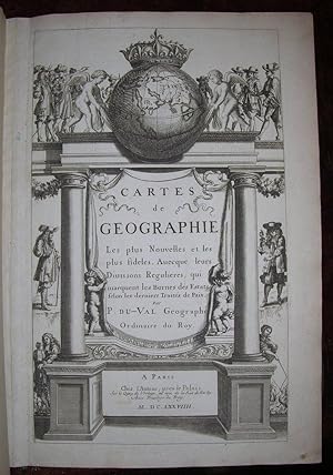
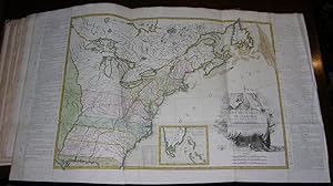
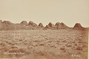
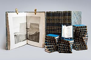
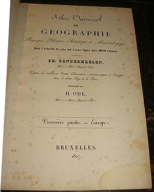
![Image du vendeur pour [MANUSCRIT] Cartes particuličres par gouvernements de la province de Dauphiné mis en vente par Pingel Rare Books](https://pictures.abebooks.com/inventory/md/md30884224826.jpg)
![Image du vendeur pour De triangulis planis et sphaericis. (.) quae extructa est ŕ Ptolemeaeo & Copernico de Revolutionibus orbium caelestium. [Avec : ] - Problematum astronomicorum et geometricorum sectiones septem. [Avec :] - In Ptolemaei magnam compositionem, quam almagestum vocant, libri tredecim mis en vente par Hugues de Latude](https://pictures.abebooks.com/inventory/md/md30050208247.jpg)
![Image du vendeur pour [Image du monde. Nouvellement imprimée a Paris par Alain Lotrian]. Sensuyt lymaige du monde contenant en soy tout le Monde mis en III parties, cestassavoir , Asie, Affrique et Europe. Avec les pays, provinces et citez et les merveilleuses et diverses creatures qui sont dedans. mis en vente par JF LETENNEUR LIVRES RARES](https://pictures.abebooks.com/inventory/md/md22846645100.jpg)
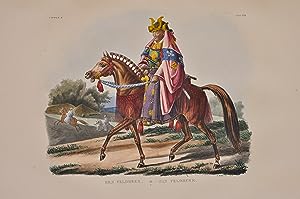
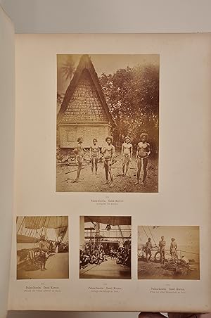
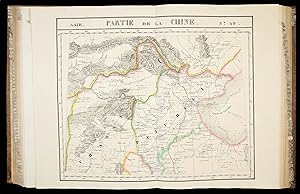

![Image du vendeur pour Voyage de découvertes aux terres Australes. Exécuté par ordre de sa Majesté l'Empereur et Roi, Sur les Corvettes le Géographe, la Naturaliste, et la Goelette le Casuarina, Pendant les Anées 1800, 1801, 1802, 1803 et 1804. [Historique] Rédigé en parti. - [THE FIRST PUBLISHED COMPLETE AND FULLY DETAILED MAPPING OF AUSTRALIA] mis en vente par Lynge & Sřn ILAB-ABF](https://pictures.abebooks.com/inventory/md/md30288308956.jpg)
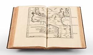

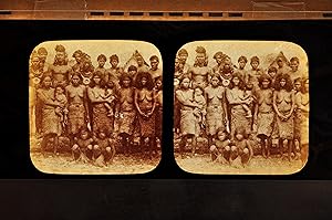
![Image du vendeur pour TABULA TERRE NOVE [THE ADMIRAL'S MAP] mis en vente par William Reese Company - Americana](https://pictures.abebooks.com/inventory/md/md31022019826.jpg)

![Image du vendeur pour Geographischer und Physischer Atlas von Neu-Spanien. gegründet auf astronom: trigonom: und Barometer Messunden [old ink mss.]. mis en vente par Altea Antique Maps](https://pictures.abebooks.com/inventory/md/md31449501850.jpg)
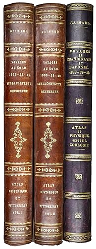
![Image du vendeur pour I. Geographiae libri octo, recognitiam diligenter. [II. Galliae Tabule Geographicae. Belgii Inferiores Geographicae Tabule]. mis en vente par JF LETENNEUR LIVRES RARES](https://pictures.abebooks.com/inventory/md/md22846645099.jpg)