Montant total (1 article articles) :
Destination de la commande :

geographie (646 résultats)
Passer aux résultats principaux de la recherche
Type d'article
- Tous les types d'articles
- Livres (621)
- Magazines & Périodiques (1)
- Bandes dessinées
- Partitions de musique
- Art, Affiches et Gravures (10)
- Photographies
- Cartes (14)
-
Manuscrits &
Papiers anciens
Etat
Reliure
Particularités
- Edition originale (34)
- Signé (3)
- Jaquette (21)
- Avec images (588)
- Sans impression ŕ la demande
Livraison gratuite
Pays
Evaluation du vendeur
-

Geographie opus nouissima traductione e Grecorum archetypis castigatissime pressum
Edité par Johann Schott, 1513
Vendeur : Arader Galleries - AraderNYC, New York, NY, Etats-Unis
Evaluation du vendeur :

Livre Edition originale
Hardcover. Etat : Near Fine. 1st Edition. THE DuPONT COPY. Folio (18 1/2 x 12 1/2 in.; 469mm x 317mm). 47 woodcut maps by Martin Waldseemüller (all but 2 double-page) including "Tabula terre nove," the last map ("Lotharingia") printed in colors, 4 woodcut diagrams in text, one large woodcut of an armillary sphere on K1; lower portion of the title-page renewed with 12 lines of text on verso supplied in excellent pen-work facsimile, lower portion of last leaf renewed, without the final blank leaf, some browning and staining, a few leaves skillfully repaired affecting the image in 3 maps: Italy, Switzerland and the Upper Rhineland. Contemporary blind-stamped paneled calf over wooden boards, each cover decorated with alternating fillets of a stag and hunter, and a thistle and bird roll tool, fore-edge lettered in Greek: "Ptolemaio," original vellum page-markers; brass catches and clasps and cornerpieces renewed to style, recently and expertly conserved by James and Stuart Brockman Ltd, full report available upon request. THE FIRST "MODERN" EDITION OF PTOLEMY AND "THE MOST IMPORTANT OF ALL PTOLEMY EDITIONS" (Streeter Sale I:6). The first modern atlas, prepared by Martin Waldseemüller using the translation of Mathias Ringmann. This is one of the most important editions of Ptolemy, containing many new regional maps: twenty new maps based on contemporary knowledge "unlike many of the alleged 'new' maps produced by earlier editors, [they] contained a great deal of new information, and in nearly every case they were decided improvements over anything that had been previously offered" ("The World Encompasssed," 56), and were included in addition to the traditional body of twenty-seven Ptolemaic maps derived from the 1482 Ulm edition (or possibly from the manuscript atlas of Nicolaus Germanus that served as a source for the latter). Schott's edition while initiated by the most famous of all early sixteenth-century cosmographers, Martin Waldseemüller and his associate Mathias Ringmann, partly at the expense of Duke René of Lorraine, was brought to completion by Jacobus Eszler and Georgius Ubelin. THE FIRST MAP IN AN ATLAS ENTIRELY DEVOTED TO AMRERICA. The atlas contains "Tabula terre nove." Often called the "Admiral's map" after Columbus, unlike its predecessor by Peter Martyr, it shows the continental Atlantic seaboard, with a continuous coastline stretching from the mouth of the Rio de la Plata to the St. Lawrence River. Although not to scale the map depicts a complete Gulf of Mexico. The island of Cuba is here named Isabella after Queen Isabella of Spain, who funded Columbus's expedition of 1492. The first issue of Waldseemüller's map published in 1507 introduced for the first time "America" to name South America, but in this atlas issue he acknowledges Columbus's discovery with the legend: "Hec terra cum adiacentib insulis inuenta est per Columbus ianuensem ex mandato Regis Castelle" (This land with its adjacent islands was discovered by Columbus, sent by the king of Castile). The map of Lotharingia (the first map of the Duchy of Lorraine), printed in black, red and olive, is one of the earliest examples of color-printing. This edition was reprinted in 1520 using the same woodcut blocks. REFERENCES: Fairfax Murray, German 348 and 348A; Harrisse 74; Phillips 359; Sabin 66478; Shirley 34 PROVENANCE: Copious contemporary marginal scholarly annotations in Greek and Latin; Pierre S. du Pont III (1911-1988), his sale, (Collection of Navigation, Christie's 8 October 1991, lot 214).
-
De triangulis planis et sphaericis. (.) quae extructa est ŕ Ptolemeaeo & Copernico de Revolutionibus orbium caelestium. [Avec : ] - Problematum astronomicorum et geometricorum sectiones septem. [Avec :] - In Ptolemaei magnam compositionem, quam almagestum vocant, libri tredecim
Edité par (Heinrich Petri & Peter Perna), Basel, 1561
Vendeur : Hugues de Latude, Villefranche de Lauragais, France
Membre d'association : ILAB
Evaluation du vendeur :
Edition originale
*** Premičre édition donnée par Daniel Santbech de cet ouvrage de Regiomontanus. Il l'a revu et commenté ŕ la lumičre des découvertes de Copernic. Rédigé en 1464, ce texte n'a été publié pour la premičre fois qu'en 1533 ŕ Nuremberg. Illustré de trčs nombreux bois gravés dans le texte. Relié ŕ la suite : - SANTBECH. Problematum astronomicorum et geometricorum sectiones septem. Basileae, Per Henrichum Petri, et Petrum Pernam, 1561. In-folio de (20), 294, (2) pp. Premičre édition. Une suite de l'ouvrage précédent, qui traite des applications pratiques. La plus grande partie est consacrée ŕ l'astronomie et ses instruments. L'auteur traite aussi des cadrans solaires, de géographie, de navigation, d'arpentage, de balistique. Le mathématicien et astronome Daniel Santbech était hollandais. En 1651, Riccioli a donné son nom ŕ un cratére de la Lune. Relié avec : - REGIOMONTANUS, PEURBACH. In Ptolemaei magnam compositionem, quam almagestum vocant, libri tredecim. Conscripti ŕ Joanne Regiomontano . ; in quibus vniversa doctrina de coelestibus motibus, magnitudinibus, eclipsibus &c., in epitomen redacta, proponitur. Nuremberg, J. Berg, U. Neuber, 1550. In-folio de (116) ff. Troisičme édition de la premičre traduction complčte, donnée par Peurbach et Regiomontanus ŕ partir d'un manuscrit grec découvert ŕ Byzance. (La premičre Venise, 1496, la 2e Bâle, 1543). Titre en noir et rouge et nombreux bois gravés dans les marges. Exemplaire dans une magnifique reliure en maroquin aux armes et au chiffre de JACQUES-AUGUSTE DE THOU. Ce volume porte ses seules armes et a donc été relié avant 1587, date de son premier mariage. Jacques-Auguste de Thou (1553-1617) commença sa collection vers 1573. Ce fameux bibliophile a rassemblé des milliers de livres sur tous les sujets, mais, il est cependant rare de rencontrer un livre de science portant ses armes. Celui-ci a été particuličrement bien relié, dans un maroquin précieux, probablement de Turquie. *** In-folio de (8), 146, (38) pp. Maroquin citron, dos ŕ nerfs orné du chiffre de Thou, plats aux armes du męme, encadrements dorés, (Reliure de l'époque.) - - - - - - - - - - - - - - - - - - - - - - - - - - - - - - - - - - - - - - - - - - - - - - - - - - - - - - - - - - - - - - - - - - - - * Copy from the famous library of Jacques Auguste de Thou, in a splendid morroco binding. First edition given by Daniel Santbech. He revised and augmented this work by Regiomontanus, according to Copernicus' discoveries. Written in 1464, it was published for the first time in 1533 in Nuremberg. "The first systematic treatise on plane and spheric trigonometry to be published in Europe. (.) With 'De triangulis' trigonometry was established as an independent discipline. Regiomontanus' original purpose, however, had been to furnish astronomers with a mathematical technique essential for their studies, and in this De triangulis had a success perhaps greater than its author could have dreamed of. For in 1539 Georg Joachim Rheticus presented a copy of the work's 1533 edition as a gift to Copernicus. The great astronomer had already written the trigonometrically-based portion of his De Revolutionibus without knowledge of his predecessor's treatise. After reading the new book, Copernicus modified the presentation of several of his own indispensable theorems by inserting two leaves in the manuscript of the De Revolutionibus. Hence, Rheticus' remark that Regiomontanus began the reconstruction of astronomy that Copernicus completed takes on a fuller meaning." (Rose, The Italian Renaissance of Mathematics). Bound with: - SANTBECH. Problematum astronomicorum and geometricorum sectiones septem . Basileae, Per Henrichum Petri, and Petrum Pernam, 1561. First edition. A continuation with practical applications of the previous work. Most of the book is devoted to astronomy and its instruments. The author also deals with sundials, geography, navigation, surveying, ballistics . Daniel Santbech (fl. 1561) was a Dutch mathematician and astronomer. In 1651, Riccioli gave his name to a crater on the Moon. Both volumes are illustrated with many woodcuts in text. Bound with: - REGIOMONTANUS, PEURBACH. In Ptolemaei magnam compositionem, quam almagestum vocant, libri tredecim. Nuremberg, Apud Ioannem Montanum & Ulricum Neuberum, 1550. Third edition of the first complete translation of Ptolemy, given by Peurbach and Regiomontanus from a Greek manuscript discovered in Byzantium. (The first Venice, 1496, the 2nd Basel, 1543). Title in black and red and many wood cuts in the margins. Contemporary yellow morroco, spine gilt with nerves, arms of de Thou gilt on boards. Splendid copy with a distinguished provenance. - -.
-
[Image du monde. Nouvellement imprimée a Paris par Alain Lotrian]. Sensuyt lymaige du monde contenant en soy tout le Monde mis en III parties, cestassavoir , Asie, Affrique et Europe. Avec les pays, provinces et citez et les merveilleuses et diverses creatures qui sont dedans.
Edité par Paris, [Lotrian], [circa 1520-1530. 1530, 1530
Vendeur : JF LETENNEUR LIVRES RARES, Saint Briac sur mer, France
Membre d'association : ILAB
Evaluation du vendeur :

Signé
1 vol. in-8° (187 x 140 mm) de: [26] ff. (dont titre gravé et 1 blason gravé sur le dernier f.). Plein maroquin rouge XIXe, dos ŕ faux nerfs orné et titré ŕ l'or, encadrements de frises dorées sur les plats avec le navire de Christophe Colomb dans chaque angle, encadrement intérieur, emboitage moderne en demi maroquin rouge et toile (Reliure signée par Chambolle-Duru pour le Baron Pichon). (étiquette "288" de la bibliothčque de Charles Fairfax Murray; ex-libris ŕ l'or sur maroquin rouge du Baron Pichon avec sa devise "MEMOR FVI DIERVM ANTIQVORV PS. CXLII."; inscription en page de garde ŕ l'encre "exemplaire de Fernand Colomb mort en 1539, fils de Christophe Colomb. Acheté en 1885. hez. Edition non citée.") Exceptionnel exemplaire de la célébre "Colombina Biblioteca" de cet ouvrage géographique populaire constitué d un recueil médiéval de géographie, d'astronomie et d'autres sciences physiques, texte qui a circulé sous forme de vers et de prose depuis le 13čme sičcle. Il est attribué ŕ Gautier de Metz, počte et prętre français qui l aurai produit (vers 1246), se basant sur le texte latin médiéval « Imago mundi » d'Honorius Inclusus. Le počme de Gautier est l'un des nombreux ouvrages médiévaux «encyclopédiques» qui décrivent la création, la géographie et l'astronomie avec des passages factuels et imaginaires. Des monstres, des trésors et des terres lointaines sont évoqués dans ce počme pseudo-scientifique, qui a été traduit en plusieurs langues au moyen âge et magnifiquement illustré dans de nombreux manuscrits. Le počme "Mappemonde", attribué ŕ Gautier de Metz, fut probablement transformé en prose par Maistre Gossouin en 1265. La présente édition reproduit celle de 1485 due Cailant, mais avec quelques ajouts ŕ la fin. Un exemplaire similaire est présent dans les collections de la NY public library. Ferdinand Columbus (1488-1539), fils du découvreur du Nouveau Monde, accompagna son pčre lors de son quatričme voyage en Amérique entre 1502-1504. Aprčs sa mort, Il rentra en Espagne, puis voyagea dans toute l'Europe et constitua une bibliothčque de plus de 15 000 livres. Il semble avoir eu un intéręt particulier pour les éditions de l'Image du Monde. Ce livre et d'autres tels que l'Imago Mundi de Pierre d'Ailly ont inspiré les premiers plans de découverte de son pčre. La bibliothčque de Ferdinand fut confiée ŕ la bibliothčque de la cathédrale Saint-Paul de Séville. Pendant les XVIe et XVIIe sičcles la bibliothčque, comme d'autres bibliothčques de la Renaissance, elle fut négligée. Ainsi, Lorsque la bibliothčque fut inventoriée en 1684, son contenu avait diminué ŕ 5000 volumes. Les livres de la bibliothčque de Ferdinand Columbus sont extręmement rares sur le marché. D aprčs nos recherches, aucun autre volume de la « Colombina Biblioteca » n est passé en salle des ventes ces cinquante derničres années. Provenance: de la bibliothčque de Ferdinand Columbus (ex-libris, "Colombina Biblioteca"), puis du baron Pichon ("acheté en 1885") avec son ex-libris de cuir rouge au dos du premier plat, puis de Charles Fairfax Murray (avec l'étagčre "288" au verso du premier plat). Selon Murray, c'est le seul exemplaire connu de cet ouvrage de cosmographie. 1 vol. in-8° (187 x 140 mm) of: [26] following. (including engraved title and 1 coat of arms engraved on the last f.). Full 19th century red morocco, spine with false raised bands decorated and titled in gold, frames of gilded friezes on the covers with Christopher Columbus' ship in each corner, interior frame, modern casing in half red morocco and canvas (Binding signed by Chambolle -Duru for Baron Pichon). (label "288" from the library of Charles Fairfax Murray; gold bookplate on red morocco by Baron Pichon with his motto "MEMOR FVI DIERVM ANTIQVORV PS. CXLII."; inscription on the flyleaf in ink " copy of Fernand Colomb died in 1539, son of Christopher Columbus. Purchased in 1885. hez. Edition not cited.") Exceptional copy from the famous« Colombina Biblioteca » of this scarce popular geographical work consisting of a medieval collection of geography, astronomy and other physical sciences, a text that has circulated in the form of verse and prose since the 13th century. The work is attributed to Gautier de Metz, French poet and priest who produced it around 1246, based on the Medieval Latin text "Imago mundi" by Honorius Inclusus. Gautier's poem is one of the many "encyclopedic" medieval works that describe creation, geography and astronomy with factual and imaginary passages. Monsters, treasures and distant lands are evoked in this pseudo-scientific poem, which has been translated into several languages during the Middle Ages, and beautifully illustrated in numerous manuscripts. The poem "Mappemonde", attributed to Gautier de Metz, was probably transformed into prose by Maistre Gossouin in 1265. This edition reproduces that of 1485 due Cailant, but with some additions at the end. A similar copy is present in the collections of the NY public library. Provenance: from the library of Ferdinand Columbus (ex-libris, "Colombina Biblioteca"), then from Baron Pichon ("bought in 1885") with his ex-libris in red leather on the front, then Charles Fairfax Murray (with shelf "288" on the back of the cover). According to Murray, this is the only known copy of this edition. Ferdinand Columbus (1488-1539), son of the discoverer of the New World, accompanied his father during his fourth voyage to America between 1502-1504. After his death, he returned to Spain, then traveled all over Europe and set up a library of more than 15,000 books. He seems to have had a particular interest for the editions of the "Image du Monde". This book, and others such as Imago Mundi by Pierre d'Ailly, inspired his father's first discovery plans. Ferdinand's library was entrusted to the library of St. Paul's Cathedral in Seville. During the 16th and 17th centuries the library, like other Renaissance libraries, was neglected. Thus, when the library was inventoried in 1684, its contents had decre.
-
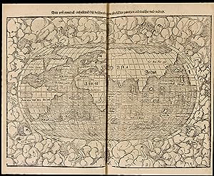
Orbis Typus Universalis Iuxta Hydrographorum Traditionem
Edité par Strassburg: Johann Schott 1513., 1513
Vendeur : Arader Galleries - AraderNYC, New York, NY, Etats-Unis
Evaluation du vendeur :
Single sheet, float-mounted and framed (18 2/8 x 23 6/8 inches). Double-page woodcut map of the world by Martin Waldseemuller, showing the modern discoveries, centred on Europe, Africa and Asia, but with the coastline of Brazil and the islands of Isabella (Cuba) and Spagnolla (Haiti/Dominican Republic) to the west, the title within the image across the top, and the whole decorated with extensive rhumb lines (the top margin and first half inch of the map supplied in facsimile, washed). One of the earliest obtainable maps of the world to show modern discoveries, from Ptolemy's "Geographie opus nouissima traductione e Grecorum archetypis castigatissime pressum", published in Strassburg by Johann Schott in 1513. This was the first modern atlas, prepared by Martin Waldseemuller, scholar-geographer from the small town of St. Die in Lorraine, using the translation of Mathias Ringmann. It is one of the most important editions of Ptolemy, containing many new regional maps: twenty new maps based on contemporary knowledge with a great deal of new information. "Orbis Typus Universalis" redraws the British Isles, India, Sri Lanka and Madagascar, and Greenland is shown as an elongated peninsular attached to the top of Scandinavia, however the "representation of the Americas is most rough and incomplete, as if Waldseemuller felt uncertain about the shape of the New World, South America is shown in part outline; north of it are the islands of "Isabella" (Cuba) and "Spagnolla" (Haiti/Dominican Republic)" (Shirley 35). In his introductory text to the atlas, Ringmann referrs to the "Charta autem Marina", derived from observations made by Christopher Columbus, or "The Admiral", as a major source of information for the coastline of the New World, although Alberto Cantino's portolan map dated 1502, based on the discoveries of Gaspar Corte Real, and Nicolo Caveri's of 1505, seem more likely candidates. This information is reflected in the "Orbis Typus Universalis" and in another map in the same atlas: the first map in an atlas entirely devoted to America, "Tabula terre nove", often called the "Admiral's map", after Columbus, as it references him within the coastline of Brazil. In "Orbis Typus Universalis" the landmass remains unnamed, perhaps in a vain attempt to reverse the notion that it should be called "America", as it previously appeared in Waldseemuller's large wall map of 1507. See Burden pages xix-xxii, and 3; Shirley 35.
-
De mirabilibus quae mundi.
Edité par Venice, Nicolaum Jenson, 1473. 1473, 1473
Vendeur : JF LETENNEUR LIVRES RARES, Saint Briac sur mer, France
Membre d'association : ILAB
Evaluation du vendeur :
Edition originale
1 vol. in-folio (285 x 182 mm) de : [1] f. bl. ; [2] ff. ; [1] f. ll. [63] ff. ; [1] f. bl. Texte imprimé sur 33 lignes. Emplacement des lettrines demeuré vierge. Annotations en marge ŕ l'encre brune ŕ chaque page. Exemplaire portant dans les marges les trous des punaises qui servaient aux premiers imprimeurs ŕ positionner les ff. sur la presse. Plein veau ancien (circa 1800), dos ŕ nerfs titré ŕ l'or, roulette sur les coupes. (Dos restauré, accidents aux coins, rares taches ou rousseurs). Provenance: Clifford Rattey (ex-libris, collection dispersée par Maggs); W.R.H. Jeudwine (ex-libris, sa vente Sotheby s Londres, 18 septembre 1984, lot 28); George Abrams (ex-libris, sa vente Sotheby s Londres, 16 novembre 1989, lot 118); Maria Ludovica Borromeo Arese et Massimiliano Favia del Core (ex-libris). Premičre édition de "De Mirabilibus quae mundi", uvre majeure du grammairien et compilateur romain Gaius Julius Solinus, dans lequel cet auteur, qui a vécu au IVe sičcle aprčs JC, résume sa vision du monde ŕ partir de diverses sources telles que Pline, Pomponius Mela, Cornelius Bocchus et d'autres. L ouvrage est rédigé sous la forme d'une collection de curiosités en histoire naturelle, géographie et histoire. La compilation de Solinus sur les merveilles du monde a connu une large diffusion ŕ travers le Moyen Âge. Des citations de l ouvrage par des auteurs tels qu'Augustine, Isidore et Bede attestent de son influence depuis une date précoce et un grand nombre de manuscrits du IXe sičcle et plus tardifs témoignent de sa popularité continue. Les récits les plus saisissants et pittoresques de l ouvrage ont été transférés presque dans leur intégralité sur les cartes médiévales. L ouvrage est une des sources possibles des plus anciennes cartes du monde conservées telle que la célčbre « Mappa mundi » d'Albi (produite au VIIIe sičcle, plus ancienne carte du monde conservée), ou encore la « mappa mundi » de la cathédrale de Hereford, datée de la fin du XIIIe sičcle. (C.R. Beazeley, The Dawn of Modern Geography, I, 1987, pp.247-272). Son agencement géographique dérive en grande partie de l'histoire naturelle de Pline et de la géographie de Mela. Elle revęt une importance mondiale, ŕ la fois pour les différents pays qu'elle représente dont elle est souvent la premičre représentation conservée, pour la mémoire du monde, et pour l'histoire de la cartographie mondiale. Quand parait l ouvrage, cela fait moins de 20 ans que la Bible de Gutenberg a été imprimée : c est l époque de la genčse de l imprimerie et de la typographie dont, l imprimeur de ce livre, Nicolas Jenson (1420 - 1480) est un des précurseurs. Jenson est un graveur qui commence sa carričre d imprimeur en 1458 lorsque Charles VII l envoie ŕ Mayence pour « secrčtement » s informer sur les techniques d impression de Gutenberg. Ŕ la suite de son séjour en Allemagne, Jenson exerça l essentiel de sa carričre d imprimeur ŕ Venise et mit au point des caractčres romains qui permettaient de minimiser la quantité d encre utilisée (trčs chčre ŕ l époque) tout en augmentant la lisibilité du texte. Grâce ŕ sa parfaite maîtrise des caractčres, les historiens de la typographie considčrent que ce sont les caractčres d imprimerie les plus parfaits jamais gravés. Jenson imprimera plus de 150 ouvrages au cours de sa vie et inspira le typographe du journal The Times ŕ créer sa célčbre police qu il baptisa New Roman en l honneur de Jenson. « De Mirabilia mundi » a également été imprimée ŕ Paris la męme année par Louis Simonel "Au Soufflet Vert", toutes les autres éditions sont postérieures. Exemplaire bien complet des 68 feuillets, dont 3 blancs. Édition d une extręme rareté : seuls 2 exemplaires sont passés en vente publique ces 50 derničres années, dont un en 2011 en mauvais état et incomplet de 2 des feuillets blancs. Notre exemplaire a conservé ses larges marges qui sont abondamment annotées par une main contemporaine. Dans ces marges, on trouve également les trous de punaises caractéristiques des débuts de l impression qui permettaient de guider la presse pour que les feuillets soient imprimés uniformément. Provenance: Clifford Rattey (ex-libris, collection dispersée par Maggs); W.R.H. Jeudwine (ex-libris, sa vente Sotheby s Londres, 18 septembre 1984, lot 28); George Abrams (ex-libris, sa vente Sotheby s Londres, 16 novembre 1989, lot 118); Maria Ludovica Borromeo Arese et Massimiliano Favia del Core (ex-libris) 1 vol. in-folio (285 x 182 mm) of : [1] f. bl. ; [2] ff. ; [1] f. ll. 63] ff ; [1] bl. f. ; [1] f. ll. Text printed on 33 lines. Location of the ornamental initial remained blank. Annotations in the margins in brown ink on each pages. Copy with the pin holes in the margins, which were used by the first printers to position the ff. on the press. Full calf binding circa 1800. First edition of "De mirabilibus quae mundi", major work of the grammarian and roman compiler gaius julius solinus, in which this author, who lived in the 4th century, summarizes his vision of the world from various sources such as pliny, pomponius mela, cornelius bocchus and others. The work is written in the form of a collection of curiosities in natural history, geography and history. The compilation of solinus on the wonders of the world was widely distributed throughout the middle ages. Quotes from the book by authors such as augustine, isidore and bede attest its influence from an early date and a large number of manuscripts from the ninth century and later attest its continued popularity. The most striking and picturesque accounts of the work were transferred almost in their entirety to medieval maps. The book is one of the possible sources of the oldest preserved maps of the world such as the famous "mappa mundi" of albi (produced in the 8th century, the oldest preserved map of the world), or even the "mappa mundi" of the cathedral. Of hereford, dated from the end of the 13th century. (c.r. Beazeley, the dawn of modern geography, i, 1987, pp. 247-272): its geographical arrang.
-
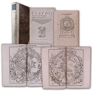
Geographicae Enarrationis, Libri Octo.
Edité par Fries / Ptolemy / Villanovanus (Servetus), 1541
Vendeur : Barry Lawrence Ruderman, La Jolla, CA, Etats-Unis
Membre d'association : ABAA ILAB
Evaluation du vendeur :
Carte
No Binding. Etat : VG. Fries / Ptolemy / Villanovanus (Servetus) / 1541 / Geographicae Enarrationis, Libri Octo. (Safe 1, 92392) Folio. 17th-century or early-18th-century mottled calf. Spine in seven compartments separated by raised bands. Elaborate gilt tooling in all but the second where a morocco title label reads "PTOLEM | GEOGRA[F]". (Overall rubbing. Minor wear and splitting at the hinges.) Front flyleaf with a 19th-century black ink stamp "LESECQ", possibly J.L.H. Le Secq, though not conforming to the stamps in L.1336. Housed in modern vellum over red cloth clamshell box. (One or two small wormholes scattered throughout. Faint marginal dampstain in places. Some minor faint stains. Woodcut on page 128 trimmed at the outside edge.) Collation: 149, [1] pages, 1 leaf; 50 woodcut maps, all but one double-page (Plansipheric world map bound between maps 23 and 24); [avi], [bvi], [cvi], [dvi], [evi], [fvi], [gvi], [hvi] (i.e., complete). A Handsome Example of the 1541 Edition of Fries Adaptation of Waldseemuller s Ptolemy. A very clean and attractive example of Fries 1541 edition of Ptolemy, including the first map in a Ptolemy atlas to name America and the suites of ancient and modern maps. The so-called Fries Ptolemy was first published in 1522 by Johann Koberger. Fries is generally thought to have edited the maps. The 1522 edition of Fries' work is very rare, suggesting that the work was not commercially successful. In 1525, an improved edition was issued, with a re-edit of the text by Willibald Pirckheimer, from the notes of Johannes Regiomontanus. After Gr ninger died in 1531, the business was continued by his son Christoph, who seems to have sold the materials for the Ptolemy to two Lyon publishers, the brothers Melchior and Gaspar Trechsel, who published a joint edition in 1535, before Gaspar Trechsel published an edition in his own right in 1541. Fries was initially a physician, working in various places in the Alsace region and Switzerland before settling in Strasbourg around 1519. He was known for his medical writings and met the Strasbourg printer and publisher Johann Gr ninger, who was responsible for printing several of Waldseemuller's maps and supervising the cutting of the maps for the 1513 edition of Ptolemy edited by the St. Die group of scholars, including Walter Lud, Martin Ringmann, and Martin Waldseemuller. In addition to the book's complement of maps, it includes a full-page armillary sphere showing the inhabited earth by Albrecht D rer (Meder 262). The Ancient Maps Fries' work follows the typical cartographic tradition in Europe in the 15th and early 16th centuries in that it reproduces the maps of Claudius Ptolemy, the famous Greco-Roman mathematician, astronomer, geographer who was active in the 2nd Century AD. The Modern Maps Generally, the maps in the modern section are reduced copies by Lorenz Fries of the modern maps that appeared in Martin Waldseemuller s Ptolemy of 1513, Geographie Opus Novissima. To that group, Fries has added a map of Southeast Asia, East Asia, China, and Japan, and a navigational map of the world. Map.
-
TABULA TERRE NOVE [THE ADMIRAL'S MAP]
Edité par Johann Schott, [Strassburg, 1513
Vendeur : William Reese Company - Americana, New Haven, CT, Etats-Unis
Membre d'association : ABAA ESA ILAB SNEAB
Evaluation du vendeur :

Woodblock map on two joined sheets. Overall joined sheet size: 18 1/4 x 20 3/4 inches. Evidence of previous mounting on outer margins (not touching text), light even tanning. Diagonal tear in lower left corner, with loss of paper (not affecting text). Very good. An excellent copy of the earliest obtainable printed map focusing on the western hemisphere. It is preceded only by Peter Martyr's map of the Spanish Main (Seville, 1511), and Johannes Stobnicza's 1512 map. This was the most important map featured in Johann Schott's edition of Claudius Ptolemy's GEOGRAPHIE OPUS NOVISSIMA TRADUCTIONE E GRECORUM ARCHETYPIS CASTIGATISSIME PRESSUM, the first modern atlas. This map depicts the eastern coast of North and South America in a continuous line from the northern latitude of 55° to Rio de Cananor at the southern latitude of 35° (approximately the Rio de la Plata), with about sixty places named. The notably blank interior of the continent is appropriately labeled "Terra Incognita." In the Caribbean, Cuba is identified as "Isabella," after Queen Isabella of Spain; Hispaniola is "Spagnolla"; and Puerto Rico is "Boriguem." Jamaica (Jamaiqua) is also featured, together with several smaller islands in the Caribbean and Bahamian archipelagos. North America is somewhat compressed, and includes a river named Caninor, quite possibly the St. Lawrence River. About twenty places are identified on the North American coastline, drawn primarily from Portuguese sources, including the Cantino Portolano PLANISPHERE (1502) and the Caverio map of the world (ca. 1505). The depiction of the Floridian peninsula and the curve of the coast of the Gulf of Mexico suggests that Waldseemüller had access to reports from as-yet unrecorded voyages. The first recorded European contact with Florida was by Ponce de Léon's voyage, which was in 1513, the same year this map was printed; the first mapping of the Gulf was done during Alonso Álvarez de Pineda's voyage in 1517-19. The text printed near the northern coast of South America explains that the land and adjacent islands were discovered by Columbus: "Hec terra cum adiacentib[us] insulis inuenta est per Columbu[m] ianuensem ex mandato Regis Castelle" ("This land with its adjacent islands was discovered by Columbus, sent by the king of Castile"). Some scholars have suggested that this was Waldseemüller's effort to correct his 1507 map, which credited Amerigo Vespucci with the discovery of America. Adding to further debate, Waldseemüller notes the source of this map as "the Admiral," with some scholars asserting this must be Columbus, and others arguing that it refers to Amerigo Vespucci. Recent scholarship suggests that it may be from an inscription on the Caverio map noted above. Regardless, this map is central to the cartographic history of the Americas. Excepting the smaller edition of this map published by Laurent Fries in Lyon (1522), it was not until 1534 that another large-scale map of the Americas was published, by Giovanni Battista Ramusio. Martin Waldseemüller (ca.1470-ca.1522) was one of the leading cartographers during the first great period of global exploration by European powers. He studied at the University of Freiburg, and then joined a group of humanist scholars based at the Abbey of St. Dié in Alsace. Waldseemüller was inspired by Vespucci's work MUNDUS NOVUS, which argued for the first time that the "New World" was a distinct landmass. Accordingly, in 1507, Waldseemüller published the first map, printed or in manuscript, to depict a separate Western Hemisphere, with the Pacific as a separate ocean (UNIVERSALIS COSMOGRAPHIA SECUNDUM PTHOLOMAEI TRADITIONEM.). This map clearly portrays the Americas as "the Fourth Part of the World," with a western coastline, showing it to be completely separate from Asia. This map was perhaps a bit too controversial at the time, and this TABULA TERRE NOVE, while still revolutionary, may have been his attempt to scale back the claims in the 1507 map. Here, Waldseemüller does not show a western coastline, leaving the possibility of the Americas as a separate landmass to be ambiguous. The label "America" is also absent, and credit for discovery is given solely to Columbus. In spite of this, "America" was utilized by Mercator in 1538, and from then on was the name of the New World. This striking map is a foundational item in the history of cartography, and is uncommon to find separate from Schott's Ptolemy. BARLOW SALE 2037. EUROPEAN AMERICANA 513/6. HARRISSE 74. JCB (3)I:57-58. SABIN 66478. SHIRLEY, WORLD MAPS 34. STREETER SALE 6. PHILLIPS, ATLASES 359. WORLD ENCOMPASSED 56. Bagrow, HISTORY OF CARTOGRAPHY, p.126. PANZER VI:283. PROCTOR 10271. SHIRLEY, BRITISH ISLES 10. Stevens, PTOLEMY'S GEOGRAPHY (1908), p.44.
-
Cosmographia, sive de situ orbis.
Edité par Venice, Erhard Ratdolt, 18 Juillet 1482. 1482, 1482
Vendeur : JF LETENNEUR LIVRES RARES, Saint Briac sur mer, France
Membre d'association : ILAB
Evaluation du vendeur :
Edition originale
1 vol. in-8° (218 x 158 mm) de : [1] f. (dont carte du monde gravée et rehaussée en frontispice), [46] ff. (Titre en rouge, grandes et petites lettrines gravées sur bois). Nombreuses annotations manuscrites d'époque ŕ l'encre brune dans les marges. Plein vélin ancien, tranche-fils traversant les coiffes, traces de lacets et de titrage ŕ l'encre brune. (Salissures et défauts d'usage). Premičre édition illustrée du tout premier ouvrage latin consacré ŕ la géographie, seule édition incunable ŕ contenir les deux traités du célčbre géographe romain. Pomponius Mela, qui écrivait aux alentours de 43, est le plus ancien géographe romain connu. Il donna une description qui couvre le monde connu des Gréco-Romains. On ne sait rien de lui, sinon son nom et son lieu de naissance qu'il indique lui-męme, la petite ville de Tingentera ou Cigentera dans la province de Bétique, dans la baie d'Algésiras. On date sa vie de la période de l'empereur Claude par déduction des indications géographiques qu'il donne dans ses ouvrages : la désignation de la ville d'Afrique romaine sous le nom de Césarée, nom que lui donna Juba II sous Auguste ainsi que la référence qu'il fait ŕ Cornélius Népos, écrivain décédé sous le rčgne d'Auguste. Le triomphe qui fait suite ŕ la conquęte de la Bretagne en 424, ne peut ętre que celui de Claude en vu de la remarque précédente. Pomponius Mela est l auteur qui présente le tableau le plus complet de l état de la géographie vers le milieu du Ier sičcle de l čre chrétienne. Son présent ouvrage est écrit dans un style typiquement latin et agrémenté çŕ et lŕ de métaphores. En dehors des chapitres géographiques de l'Histoire naturelle de Pline l'Ancien (oů Mela est cité comme une référence importante), le De situ orbis est le seul traité sur le sujet en latin classique. La carte du monde reliée en frontispice, gravée sur bois, d'inspiration Ptolémaďque, fut la seconde carte ŕ ętre imprimée en Italie (Campbell p.119). Elle montre l'Europe, l'Asie et la partie nord de l'Afrique, avec le Nil représenté avec comme sources dans deux lacs, l'un directement sur l'équateur, et l'autre juste au sud de celui-ci. Ces lacs se sont recoupés avec ceux que l'on appelle maintenant le lac Albert et le Victoria Nyanza, montrant que leur emplacement était supposé, sinon connu des géographes, au moins quatre sičcles avant leur découverte tardive. Au sud, des rivičres qui montent des montagnes et s'écoulent dans ces lacs, le Niger en Afrique de l'Ouest sont également représentées. Cette carte est aussi la premičre ŕ représenter la connaissance portugaise de l époque de la côte ouest de l'Afrique qui conduit six ans plus tard au franchissement du Cap de Bonne-Espérance. Campbell suggčre que l'imprimeur de l'édition, Erhard Ratdolt, pourrait avoir été le cartographe, puisque ceci et sa carte T-O de 1480 sont les deux premičres cartes de gravure sur bois imprimées en Italie. Cette carte sera copiée pour une édition de Salamanque ainsi que pour la Chronique de Nuremberg de Schedel. Premičre édition de la traduction en vers de Priscianus du De situ orbis de Dionysius; l édition de Ratdolt est la seule édition incunable ŕ contenir les deux traités géographiques. L exemplaire présente de nombreuses annotations manuscrites contemporaines dans ses larges marges. Bel exemplaire de cet ouvrage de toute rareté. 1 vol. 8vo (218 x 158 mm) of: [1] f. (including engraved and enhanced world map as frontispiece), [46] ff. (Title in red, large and small initials engraved on wood). Numerous period handwritten annotations in brown ink in the margins. Full old vellum, thread cutting through the caps, traces of laces and titling in brown ink. (Dirt and defects of use). First illustrated edition of the very first Latin work devoted to geography, the only incunable edition to contain the two treatises of the famous Roman geographer. Pomponius Mela, who wrote around 43, is the oldest known Roman geographer. He gave a description that covers the known world of the Greco-Romans. Nothing is known of him, except his name and place of birth which he indicates himself, the small town of Tingentera or Cigentera in the province of Betic, in the bay of Algeciras. His life is dated from the period of the Emperor Claudius by deduction of the geographical indications he gives in his works: the designation of the city of Roman Africa under the name of "Caesarea", name given by Juba II under Augustus. the reference he makes to Cornelius Nepos, a writer who died in the reign of Augustus. The triumph that follows the conquest of Brittany, which can only be that of Claude seen the previous remark and dates from 424. Mela is the author who presents the most complete picture of the state of geography in the middle of the first century of the Christian era. His present work is written in a typical Latin style and embellished with metaphors. Apart from the geographical chapters of the Natural History of Pline the Elder (where Mela is cited as an important reference), De situ orbis is the only treatise on the subject in classical Latin. The modified Ptolemaic map of the World was the second map to be printed in Italy (Campbell p.119). It shows Europe, Asia and the northern part of Africa, with the Nile represented with taking sources in two lakes, one directly on the equator, and the other just south of it. These lakes intersected with those now known as Lake Albert and Victoria Nyanza, showing that their location was supposed, if not known to geographers, at least four centuries before their belated discovery. To the south, rivers that rise mountains and flow into these lakes, Niger in West Africa is also represented. It is also the first map to represent the Portuguese knowledge of the time of the west coast of Africa which leads six years later to cross the Cape of Good Hope. Campbell suggests that the publisher, Erhard Ratdolt, might have been the cartographer. This map will be copied for an edition of Salamanca as well as for Schedel's Nuremberg Chro.
-
Cosmographey oder beschreibung aller Länder herrschafften, fürnemsten Stetten, geschichten, gebreüche, hantierungen etc. Beschriben durch Sebastianum Munsterum, auch durch in selbst gebessert, an welt und natürliche historie, jetzunder aber bisz auff das 1569 jar?
Date d'édition : 1569
Vendeur : Librairie Camille Sourget, Paris, France
Membre d'association : ILAB
Evaluation du vendeur :
Couverture rigide. Etat : Trčs bon. Basel, in der Officin Henricpetrina, Im Jar 1569.In-folio de (100) ff. préliminaires y compris 1 frontispice gravé, suivis de 1467 pages de texte et gravures, la derničre non chiffrée pour la marque de l'imprimeur. Plein veau brun, encadrement d'un double filet doré sur les plats ornés d'une réserve centrale dorée arabisante surmontée sur le plat supérieur des chiffres H. C. H. avec la date de 1570 frappée or dessous, dos ŕ quatre nerfs orné de fleurons ŕ froid, coiffes et coins restaurés, tranches jaspées. Intéressante et élégante reliure de l'époque.310 x 205 mm. --- Trčs rare édition non décrite par Sabin de l'un des plus célčbres ouvrages de voyages, découvertes et géographie de la Renaissance ornée de 26 cartes sur double page dont la carte du « Nouveau Monde » présentant le continent et les îles d'Amérique, 37 vues et plans de ville sur double page illustrant notamment le plus ancien plan de Paris et la premičre carte de Suisse, 3 vues de villes dépliantes (Worms, Heidelberg et Vienne), 17 vues et plans de villes ŕ pleine page, 45 autres vues de villes et prčs de 1000 gravures sur bois illustrant la spécificité des différentes régions du monde.La Cosmographia Universalis de Münster fut l'un des ouvrages les plus lus du XVIe sičcle et on peut vraisemblablement lui attribuer la seconde place en termes de popularité aprčs la Bible. Ce succčs fut en partie dű aux excellentes gravures sur bois, dont certaines de Hans Holbein le Jeune, Urs Graf, Hans Rudolph Manuel Deutsch ou encore David Kandel. Au total plus de 120 collaborateurs ont participé ŕ cette ?uvre. L'ouvrage était ŕ l'époque une référence en géographie et en histoire. On y retrouve de nombreuses illustrations des modes de vies de l'époque, de męme que des vues des villes en doubles pages et de nombreuses cartes. Ces cartes couvraient de "nouvelles îles derričre l'Espagne jusqu'ŕ l'Orient vers le pays des Indes" (l'Amérique et le contine /// Basel, in der Officin Henricpetrina, Im Jar 1569.Folio [310 x 205 mm] of (100) prel. ll. including 1 engraved frontispiece, followed by 1467 pp. of text and engravings, the last one not numbered bearing the printer's mark. Full brown calf, double gilt fillet on the covers with a gilt medallion in the center decorated in an Arabic manner, and surmounted by the monogram H.C.H. on the front cover with the date 1570 gilt-stamped underneath, spine ribbed decorated with blind-stamped fleurons, extremities of the spine and corners restored, sprinkled edges. Interesting and elegant contemporary binding. --- Very rare edition not described by Sabin of one of the most famous travel and geography books from the Renaissance, illustrated with 26 double-page maps including the map of the "New World" showing the American islands and continent, 37 views and maps of cities on double-page including for example the oldest map of Paris and the first map of Switzerland, 3 folding views of cities (Worms, Heidelberg and Vienna), 17 full-page views and maps of cities, 45 other views of cities and almost 1000 woodcuts depicting the specificities of the various regions of the world.First description of the world from a German perspective, the Cosmographia was by far the most exhaustive work published so far on the subject, compiling an incredible sum of knowledge about Europe, Asia, Africa and the New World.Munster's Cosmographia was one of the most read works in the 16th century and it occupies the second position in terms of popularity after the Bible. This huge success was partly due to the very good woodcuts, by Hans Holbein the younger, Hans Rudolph, David Kandel, Urs Graf, Manuel Deutsch and many others. More than 120 artists worked together to produce this book. This work was a reference book at the time regarding geography and history. The illustration includes a frontispiece, many double-page and folding plates, and innumerable plates figures in the text.The American part is.
-
Cosmographia [with:] De situ orbis
Edité par Erhard Ratdolt, Venice, 1482
Vendeur : Donald A. Heald Rare Books (ABAA), New York, NY, Etats-Unis
Membre d'association : ABAA ILAB
Evaluation du vendeur :
Edition originale
Two volumes in one. 4to. (7 1/2 x 5 3/4 inches). Sixth edition. A-F8. 48 ff. 96 pp. 30 lines per page. Cosmographia: 1-29 ff. De situ orbis: 30-48 ff. Full-page woodcut map of the world on a Ptolemaic cone-shaped projection with architectural border and letterpress text. Woodcut and floriated initials. Rubricated throughout. Gothic letter Latin text. Border of the woodcut map insignificantly shaved. Finely bound in green full morocco by Zaehnsdorf London with binder's ticket, gilt paneled, five raised bands forming six gilt-paneled compartments, gilt-lettered titles in second and third compartments with date in sixth, marbled endpapers, all edges sprinkled red Rare 1482 Ratdolt edition of Mela's incunable "Cosmographia," the first edition of the first Latin work dedicated to geography to include a map of the world. It is only the second woodcut world map printed in Italy. "Mela's concept of the world as published here, ten years before the discovery of the New World, was the most widely accepted cosmography in Europe." [Streeter] The present title is so foundational to our understanding of the modern world that two of the most important book collectors, E. D. Church and Thomas W. Streeter, both listed it first in their collection catalogs. For the map in this edition of Cosmographia by Mela, the earliest known Roman geographer, was the first map to incorporate knowledge from the Portuguese explorations of the West Coast of Africa. This map modified the Ptolemaic rendering of Western Africa, revealing a true Western Africa based on reports of Portugal's success further south, making it current with then-known geographical knowledge. No earlier printed map recognized this important step toward the rounding of the Cape of Good Hope, achieved by Bartolomeu Dias just six years post publication. Campbell suggests that the edition's printer, Ratdolt, may have been the mapmaker, since this and the T-O map from his 1480 edition of Rolewinck are the two earliest woodcut maps printed in Italy. The title of the map "Novellae etati ad geographie vmiculatos calles huma no viro necessarios flores aspirati votu bnmereti ponit" translates as: "If, in a new lease of life, a man seeks to attain the wormlike paths of geography, he is bound to find the flowers that belong there, for he deserves them." The map is rarely present, as Nordenskiöld relates: "The map is generally wanting, but that it really belongs to the work is shown by the watermark corresponding to the watermarks of the text." Published in the same year as Lienhart Holl's Cosmographia, Mela's world map includes additions to the Ptolemaic model. One of the more obvious changes is the addition of Scandinavia, and for the first time, the Orkney Islands off the Northeast coast of Scotland. Mela's map was cited with other early texts, including those by Macrobius, Ptolemy, Pliny, and Aristotle, as part of the reading background of Christopher Columbus, who would sail to the New World just a decade later: "In its consideration of the oceans, this work would not have been particularly useful to Columbus, but in his view of the earth, Mela raised the probablity that the Southern Hemisphere was inhabited, a novel idea for Christian believers in the biblical version of the Creation." [James Ford Bell Library] Mela, born in Spain, lived during the reign of Emperor Claudius around 40 AD. His Cosmographia was circulated in manuscript, and from the present edition, with a map. It was first printed in 1471, and it, as well as the four subsequent editions, were all without maps. Mela's was the "only formal geographical treatise in Classical Latin." [Campbell] The Cosmographia expressed concepts that were similar to those of the leading Greek geographers, yet the map which accompanies this 1482 edition exhibits the then-current school of thought, rather than Mela's own. According to Wilson, the Mela map was the model for Schedel's world map in the Nuremberg Chronicle (1493) and a Salamanca edition (1498). Within its novel architectural framework, the map is drawn on a conical projection, a modification of the Ptolemaic type. The text, a motto, the legends, and the Latin names of the winds represented by "wind heads" which surround the map are provided in letterpress. The map shows Europe, Asia (including Sri Lanka, which is drawn with a bay shaped like a keyhole), and a large part of Africa. Notable is the depiction of the Nile, with its sources in the so-called "Mountains of the Moon," by Lakes Albert and Victoria Nyanza. BMC V 286. Bod-inc M-179. BSB-Ink P-687. Brown 41. Campbell, p.119. Church 1. Essling 274. Goff M-452. GW M34876. Hain 11019. HC 11019*. ISTC im00452000. James Ford Bell Library, "The Manifest." Klebs 675.6. Nordenskiöld, p.36. Oates 1751. Polain 2661. Proctor 4385. Rhodes (Oxford Colleges) 1191. Shirley 8. Stillwell 389. Streeter Sale 1. Suarez, Shedding the Veil 7. Walsh 1809. Wilson 115.
-
Cosmographiae universalis Lib. VI.
Edité par Basel, Heinrich Petri, 1550. 1550, 1550
Vendeur : JF LETENNEUR LIVRES RARES, Saint Briac sur mer, France
Membre d'association : ILAB
Evaluation du vendeur :
1 vol in folio (327 x 215 mm) de: [12] ff., 1-474, [4], 475-480, [4], 481-1162, [2] pp.; titre entouré de 6 tableaux gravés sur bois, portrait gravé sur bois de Münster au verso; 14 cartes gravées sur bois sur double page, dont 2 cartes du monde (la premičre, de David Kandel, montrant le Nouveau Monde) et une carte des Amériques ; 39 vues de villes gravées sur bois sur double page, dont les vues « panoramiques » d'Heidelberg et de Vienne (Pages 616-618 et 682-684), chacune avec une grande vue dépliante composée de deux planches; une gravure sur bois sur double page représentant des « monstres marins et terrestres » ; environ 75 autres cartes et vues dans le texte; et environ 900 petites gravures sur bois en texte ( dont certaines répétées). Exemplaire censuré par des ratures ŕ l encre et recouverts de papier vierge aux pages : 189, 203, 223, 302, 303, 308-310, 321-322, 406, 475, 477, 478, 509, 537, 667, 874-875 et 948. Note du censeur et ex-libris du possesseur ŕ l'encre brune sur la page de garde, annotations d'époque dans la table et le texte et soulignages. (Déchirures restaurées, salissures, traces de mouillures et usures sur les bords et en marges des premiers et derniers feuillets, derničre garde postérieure). Plein veau estampé d'époque, plats ornés d'encadrements ŕ froid avec frises figurant des portraits et divers motifs, dos ŕ nerfs muet orné de filets ŕ froid, traces de fermoirs (dos anciennement refait, défauts d'usage). Premičre édition latine révisée et augmentée, de ce monumental ouvrage encyclopédique abondamment illustrée dű ŕ Sébastian Munster, rare exemplaire ayant conservé les caches de censure apposés par un juge purgatoire. Sébastian Munster (1488-1522) est un érudit polyvalent ŕ la fois cartographe, historien, astronome, mathématicien et professeur d'hébreu. Né ŕ Ingelheim sur le Rhin, il étudie l'art et la théologie ŕ Heidelberg, de 1503 ŕ 1508, et ŕ Tübingen. En 1512, il entre dans l ordre des Franciscains. Aprčs sa rencontre avec Luther, il se convertit ŕ la Réforme. De 1524 ŕ 1527, il est professeur ŕ Heidelberg. En 1528, il part enseigner la théologie et l'hébreu et les mathématiques ŕ l'université de Bâle. Il est l auteur d une « Biblia hebraďca » (1534-1535), d une grammaire et d un dictionnaire araméens. Dans son « Horologiographia » (1531-1533), il donne une forme moderne ŕ l art des cadrans solaires. Il est également l auteur d une nouvelle édition de la géographie de Ptolémée. Sa présente « Cosmographia universalis », son ouvrage majeur, sera mainte fois réédité. Publiée ŕ Bâle pour la 1čre fois en 1544 en latin, elle s'inspire du « Liber Chronicarum », aussi appelé Chronique universelle du médecin Hartmann Schedel (Nuremberg, 1493). Cette uvre collégiale monumentale est l une des premičres descriptions du monde en langue allemande. Elle dresse un état du monde au milieu du XVIe sičcle tel qu il est perçu dans l Espace rhénan, et assemble des données Géographiques, Généalogiques, zoologiques, botaniques, m urs, lois, religions, évčnements dignes de mémoire (comme le tremblement de terre ŕ Bâle). L ouvrage est un immense succčs et connait de nombreuses rééditions en latin, français, italien anglais et tchčque. Cette édition latine et l édition allemande sont publiées la męme année par le gendre de Münster, Heinrich Petri. Révisée et élargie, c est la premičre uvre de Münster ŕ contenir des vues de villes. La carte du monde moderne, « Typus Orbis Universalis », apparait également ici pour la premičre fois, remplaçant la carte du monde ptolémaďque utilisée dans les éditions précédentes (CF Shirley 77). « Pendant la majeure partie d un sičcle, [la Cosmographia de Münster] fut la principale source de connaissances géographiques, ethnographiques, historiques et scientifiques. Il s agissait d un « livre pionnier » (Wilhelm Heinricht Riehl 1873). De 1544 ŕ 1628, 36 éditions complčtes et réimpressions parurent, dont pas moins de 33 avant 1600 » (R. Oehme, introduction ŕ l'édition en fac-similé, Sebastian Munster, Cosmographei, Bâle 1550). Il fut l un des ouvrages les plus lus du xvie sičcle et on peut vraisemblablement lui attribuer la seconde place en termes de popularité aprčs la Bible. Ce succčs fut en partie dű aux excellentes gravures sur bois, dont certaines de Hans Holbein le Jeune, Urs Graf, Hans Rudolph Manuel Deutsch ou encore David Kandel. Au total plus de 120 collaborateurs ont participé ŕ cette uvre. L'ouvrage était ŕ l'époque une référence en géographie et en histoire. On y retrouve de nombreuses illustrations des modes de vies de l'époque, de męme que des vues des villes en doubles pages et de nombreuses cartes. Ces cartes couvraient de "nouvelles îles derričre l'Espagne jusqu'ŕ l'Orient vers le pays des Indes" (l'Amérique et le continent asiatique). L ouvrage comporte six parties : Livre I : Astronomie, Mathématiques, Géographie physique, Cartographie. Le livre II : Angleterre, Écosse, Irlande, Espagne, Portugal, France, Belgique, Pays-Bas, Luxembourg, Savoie, Trčves, Italie. Le livre III - Allemagne, Alsace, Suisse, Autriche, Carniole, Istrie, Bohčme, Moravie, Silésie, Poméranie, Prusse, Livonie. Livre IV: Danemark, Norvčge, Sučde, Finlande, Islande, Hongrie, Pologne, Lituanie, Russie, Valachie, Bosnie, Bulgarie, Grčce, Turquie. Livre V : Asie Mineure, Chypre, Arménie, Palestine, Arabie, Perse, Asie centrale, Afghanistan, Scythie, Tartarie, Inde, Ceylan (aujourd'hui le Sri Lanka), Birmanie, Chine, Inde de l'Est, Madagascar, Zanzibar, Amérique. Livre VI - Mauritanie, Tunisie, Libye, Égypte, Sénégal, Gambie, Mali, Afrique du Sud, Afrique de l'Est. Le présent exemplaire a le grand intéręt de conserver les stigmates de la censure religieuse pratiquée au 16éme sičcle, avec le nom du juge purgatoire l ayant expurgé inscrit sur la page de garde : Nicolas de Freising (daté du 3 aout 1796), ainsi que les caches de papier vierge apposés sur les parties du texte censuré. Un cache ôté ŕ la page 308 permet de comprendre comment le censeur opérait : préalab.
-
De natura locoru(m). Libru(m) mira eruditio(n)e & singulari fruge refertu(m), & iam primu(m) summa diligentia revisum, in lucem aeditum, quem leges diligentius, si vel cosmographia vel phisica profecisse te volueris.
Edité par (Am Ende:) Wien, H. Vietor und J. Singriener für L. & L. Alantsee,, 1514
Vendeur : Matthaeus Truppe Antiquariat, Graz, Autriche
Membre d'association : ILAB VDAO
Evaluation du vendeur :
Livre Edition originale
52 nn. Bll. mit Holzschnitt-Titelbordüre und einem ganzseit. Wappenholzschnitt Kaiser Maximilians I. (auf dem letzten Bl.). Erste Ausgabe von dem Wiener Mathematiker und Astronomen Georg Tannstetter, gen. Collimitius (1482 - 1535), herausgegeben, selten. - VD16, A 1345. Sabin: 671: "Interesting to the American collector an account of marginal note relating to Vespuccius, which seems to have insert with moveable type, on the recto of the last leaf in signature e [hier d], after the book had been printed". - "The printed editions of De Natura Locorum are particularly interesting in that they include a contemporary reference to Amerigo Vespucci and his voyages. Where Albertus wrote that the Southern hemisphere is habitable, the sixteenth century editor added: `Behold he concludes that it is habitable at 50ş beyond the equator, as Vespucci has discovered and described by his voyages in previous years`." (library udel edu). - Für die Geschichte und Entwicklung der Geographie überaus bedeutende Schrift, vermutlich zwischen 1270 und 1280 in Köln entstanden. "Albert markiert darin die Anfänge der naturwissenschaftlichen Geographie als einer selbständigen Disziplin, die über die rein beschreibende Länderkunde durch enge Verbindungen mit Physik, Astronomie, Mathematik, Biologie und Geologie hinausgeht. Die Interferenzen, insbesondere zwischen Geographie einerseits und Biologie, Geologie sowie Physik andererseits, haben bei den arabischen Autoren schon Vorläufer, wenn auch direkte Verbindungen zu Europa derzeit kaum im einzelnen nachweisbar sind. Die Beziehungen zwischen Astronomie und Mathematik einerseits und Geographie andererseits, die zur modernen Kartographie führen, kann Albert so jedoch nicht in arabischen Schriften gefunden haben. . Mit Sicherheit ist Albert der erste, der sie wissenschaftlich begründet und versucht hat, die neue Geographie in das von seinem Schüler Thomas von Aquin entworfene Wissenschaftssystem einzugliedern. . Albert hat sich mit durchaus adäquaten Mitteln bemüht, auf die Brisanz der (Bedeutung der geographischen Koordinaten) hinzuweisen. Nicht nur durch den bereits zitierten ersten Titel (de natura loci ex latitudine) führte er zum Zentrum des Gegenstandes, sondern das ganze Buch ist ihm strikt untergeordnet. Es ist in drei Traktate gegliedert. Der erste betrifft die Länge und Breite eines Ortes, wie sie von der Entfernung vom Himmelsgewölbe abgeleitet sind. . Es kann kein Zweifel bestehen, daß Albert im Titel seines Liber de natura loci ex latitudine . von Längen und Breiten im Sinn geographischer Koordinaten sprach. Ganz eindeutig argumentiert er immer wieder mit Bezug des Ortes zum Himmel, zu den Sternen, zu den Planeten, was die Schrift bei der ersten flüchtigen Lektüre in eine unvermutete Nähe zur Astrologie rückt. Aber bei genauerem Hinsehen verschieben sich die Akzente etwas. Mit der astrologischen Argumentationsweise befindet sich Albert einerseits in einem, seinen Zeitgenossen verständlichen und zugänglichen Bereich, der in einer jahrtausendelangen, alle Kulturen übergreifenden Tradition steht. . Die dann folgenden Kapitel des I. und II. Traktates sind der Entwurf einer physischen Geographie. Sie hängt eng zusammen mit Alberts astronomischen, physikalischen, mineralogischen und biologischen Schriften und beruht, besonders in den letzten beiden Bereichen, vielfach auf eigenen Beobachtungen. Die modern anmutende Frage etwa, ob und wie die Erde von der Kugelgestalt abweicht, wird von Albert (übrigens wie wenig später auch von Dante) nicht eindeutig beantwortet, sondern sie wird nur als die Meinung der alii wiedergegeben, die glauben, daß die Landmassen auf der nördlichen Halbkugel aus der Kugel herausragen, ihr also eine birnenähnliche Gestalt geben. Die Ausbeutelung der Birne glaubte übrigens Kolumbus, der Albert gelesen hatte, in Südamerika dort gefunden zu haben, wo der Orinoco herkam, dessen starke Strömung an der Mündung er sich nicht anders erklären konnte, als durch das Gefälle an einem sehr hohen Berg" (Uta Lindgren, Albertus Magnus und die Geographie als scientia naturalis. In: Archives internationales d`histoire des sciences, Bd. XLIV, 1994, S. 3 ff.). - Leicht gebräunt und nur vereinzelt leicht fleckig oder wasserrandig. Teils kleinere zeitgenössische Randnotizen oder Anstreichungen. Mehrere durchgängige Wurmgänge, gegen Ende zahlreiche (ohne Textverlust). *** *** Copyright: Matthaeus TRUPPE Buchhandlung & Antiquariat - Stubenberggasse 7 - A-8010 Graz - ++43 (0)316 - 829552 *** *** Sprache: Deutsch Gewicht in Gramm: 500 8°. Mod. HPgmt. unter Verwendung von Material des 18. Jahrhunderts.
-
![Image du vendeur pour Cosmographey: das ist, Beschreibung aller Länder, Herrschafften und fürnemesten Stetten des gantzen Erdbodens, sampt ihren Gelegenheiten, Eygenschafften, Religion, Gebräuchen, Geschichten und Handtierungen [.] jetzt aber mit allerley Gedechtnuswirdigen Sachen bis ins M.D.XCVIII. jar gemehret, mit newen Landtaflen, vieler Stetten [.] so uber die alten herzu kommen, gezieret. mis en vente par Versandantiquariat Wolfgang Friebes](https://pictures.abebooks.com/inventory/md/md30551645392.jpg)
Cosmographey: das ist, Beschreibung aller Länder, Herrschafften und fürnemesten Stetten des gantzen Erdbodens, sampt ihren Gelegenheiten, Eygenschafften, Religion, Gebräuchen, Geschichten und Handtierungen [.] jetzt aber mit allerley Gedechtnuswirdigen Sachen bis ins M.D.XCVIII. jar gemehret, mit newen Landtaflen, vieler Stetten [.] so uber die alten herzu kommen, gezieret.
Edité par Basel, (Sebastian Henricpetri, 1598)., 1598
Vendeur : Versandantiquariat Wolfgang Friebes, Graz, Autriche
Membre d'association : ILAB VDAO
Evaluation du vendeur :
Etat : 0. Letzte und umfangreichste Ausgabe des 16. Jahrhunderts (EA 1544). - Münsters Kosmographie, an der er 26 Jahre arbeitete, ist eine umfassende Sammlung der geographischen Kenntnisse der damaligen Welt; sein Werk stützt sich auf Quellen namhafter Gelehrter, enthält jedoch auch Berichte über sagenhafte Tiere und Völker. Die Beschreibung der deutschen Länder, mit zahlr. Ansichten im Text, ist besonders ausführlich gehalten. So ist die Kosmographie ungeachtet ihres Kartenmaterials ein vorwiegend historisches Werk geworden. Nur so konnte das Buch zu einer solchen Beliebtheit gelangen und durch Jahrzehnte zu einem Hausbuch des historischen und geographischen Wissens in weiten Kreisen unseres Volkes werden [.] (Burmeister, S. 14f.). - Zu Beginn die beiden Karten der antiken und modernen Welt, des weiteren Karten von Europa, Asien, Afrika und Amerika. Unter den doppelseitigen Holzschnitten befinden sich Ansichten und Pläne von Jerusalem, Konstantinopel, Kairo, Rom, Florenz, Venedig, Neapel, Paris, Bordeaux, Lissabon, Lyon, London, Basel, Genf, Augsburg, Frankfurt, Köln, Lübeck, Straßburg, Ulm usw. sowie die Darstellung mit den Seeungeheuern und Meerwundern". - Einband beschabt, bestoßen u. tlw. etw. fleckig. Rücken (bes. Kapitale) m. Bezugsfehlstellen. Schließen fehlen. Innendeckeln sowie wenige Bll. zu Beginn u. am Ende m. Wurmspuren. Wenige kl., tlw. ausgebesserte Randeinrisse bzw. -läsuren, die Falttafeln vereinzelt m. kl. Beschädigungen im Bug. Tlw. etw. finger-, braun- bzw. feuchtigkeitsfleckig (nur der Titel etw. stärker), insgesamt jedoch, besonders für ein reich illustriertes und sehr umfangreiches Volksbuch, gutes und vollständiges Exemplar. - VD16, M 6706; Burmeister 83; Sabin 51395; BM STC, German Books 632; Alden/Landis 598/73; nicht bei Adams. ge Gewicht in Gramm: 5000 Fol. Titel in Rot u. Schwarz m. Holzschn.-Portrait des Verfassers. Mit 26 doppelblattgr. Holzschn.-Karten, über 1200 tlw. ganzs. bzw. doppelblattgr. Textholzschnitten (Stadtansichten, Pläne, Portraits, Wappen usw.), 2 großen gefalt. Panoramaansichten (Heidelberg u. Wien) sowie einer Holzschn.-Druckermarke am letzten Blatt. 14 Bll., 1461 S., 1 Bl., Blindgepr. Schweinsldr.-Bd. d. Zt. über Holzdeckeln a. 5 Bünden m. 6 (davon einer alt erneuert; von 8) Eckbeschlägen u. dreiseitigem Rotschnitt.
-
[Orient:] Leonharti Rauwolfen, der Artzney Doctorn, und bestelten Medici zu Augspurg Aigentgliche beschreibung der Raiß, so er vor dieser zeit gegen Auffgang inn die Morgenländer, fürnemlich Syriam, Iudaeam, Arabiam, Mesopotamiam, Babyloniam, Assyriam, Armeniam etc. nicht ohne geringe mühe unnd große gefahr selbs volbracht: neben vermeldung etlicher mehr gar schön frembden und außländischen Gewächsen, sampt iren mit angehenckten lebendigen contrafacturen, unnd auch anderer denckwürdiger sachen, die alle er auff solcher erkundiget, gesehen und obseruiert hat. Alles in Vier underschidliche Thail mit sonderem fleiß abgethailet, unnd ein jeden weitter in seine sondere Capitel, wie dero jnnhalt in zü: end gesetztem Register züfinden.
Edité par Leonhart Reinmichel für Georg Willers, Laugingen (d. i. Lauingen), 1583
Vendeur : Antiquariat Rolf Bulang, Dautphetal, Allemagne
Membre d'association : ILAB VDA
Evaluation du vendeur :
Livre
Hardcover. Etat : Gut. 8 Blatt, 487 S., 27 Blatt, 1 unbedrucktes Blatt. Alter Pergamentband mit umgeschlagenen Vorderkanten. 4 Teile in einem Band. Mit 2 Titelvignetten in Holzschnitt und 42 ganzseitigen Pflanzenholzschnitten. Deutschsprachige Beschreibung von Rauwolfs Reise ins Heilige Land und den Vorderen Orient mit zahlreichen authentischen und zuverlässigen Beobachtungen. Graesse VI, 39; Brunet IV, 1122f.; Pritzel 7430; VD16: R 431; Short-Title Catalogue of German Books in the British Museum, p. 727. Die hier vorliegende zweite Auflage enthält erstmals den wichtigen vierten Teil mit den Pflanzenholzschnitten zuvor teils unbekannter orientalischer Gewächse (Nissen: Die botanische Buchillustration, Nr. 1587). Dem Autor zu Ehren wurde später die Gattung "Rauvolfia" der Pflanzenfamilie der Hundsgiftgewächse (Apocynaceae) benannt. "Mit besonderer Vorliebe hat Rauwolf alle medicinischen Dinge, Krankheiten, Heilmittel, Bäder, Speisen und Getränke und alle Industrien besprochen, nicht ohne daß durch Leichtgläubigkeit, wie sie der Zeit gegenüber den Erzählungen von fremden Ländern eigen war, auch manches Fabelhafte (s. die Schilderung des Greifes im 8. Capitel des 2. Buches) mit unterläuft. Rauwolf muß ein genaues Tagebuch geführt haben, er würde sonst nicht im Stande gewesen sein, eine solche Fülle einzelner genauer Angaben zu bieten" (F. Ratzel in ADB 27). In der Schilderung seiner dramatisch verlaufenen Reise gibt der Autor außerdem die erste Beschreibung des Kaffees und eines Kaffeehauses: "Under andern habens ein gut getränck / welliches sie hoch halten / Chaube von jnen genennet / das ist gar nahe wie Dinten so schwartz / vnnd in gebresten / sonderlich des Magens / gar dienstlich. Dises pflegens am Morgen frü / auch an offnen orten / vor jedermenigklich one alles abscheuen zutrincken / auß jrdinen vnnd Porcellanischen tieffen Schälein / so warm / alß sies können erleiden." (S. 102f.). Zwischen die 4 Teile des Textes hat der Buchbinder jeweils mehrere unbedruckte Leerseiten eingebunden. Der Vorderdeckel innen und das Titelblatt am oberen Rand mit handschriftlichen Vermerken von alter Hand zur Bedeutung des Buches. Der Rücken nachgedunkelt und der Vorderdeckel etwas fleckig, insgesamt handelt es sich jedoch um ein ordentliches, breitrandiges und weitgehend fleckenfreies Exemplar.
-
Pharsalia
Edité par Simon Bevilacqua, 1498
Vendeur : Librairie Amélie Sourget, Paris, France
Membre d'association : ILAB
Evaluation du vendeur :
Edition originale
Couverture rigide. Etat : Bon. Edition originale. LUCANUS, Marcus Annaeus (39-65 ap. J. -C.). PHARSALIA [with commentary by Omnibonus Leonicenus and Johannes Sulpitius Verulanus, revised by Johannes Taberius]. Venice, Simon Bevilacqua, 20 october 1498. Chancery folio of 218 leaves. A4 a-z A-C8D6,62 lines of commentary plus headline, roman type, some leaves with deckle edge at foredge, contemporary half tooled calf over wooden boards (lower pastedown with watermark o fa basilisk, Briquet 2674, dated Ferrara, 1505), two clasps, paper lettering pieces on lower cover with author s name and a red X, in modern drop-backed folding box. 307 x 212 mm. EDITION INCUNABLE CITEE PAR BRUNET. La Guerre civile, plus connue sous le nom de Pharsale, est une épopée latine inachevée, écrite en hexamčtres dactyliques, uvre principale de Lucain. Dans cette épopée, qui retrace le début de la guerre civile que se livrčrent Jules César et Pompée, entre 49 et 45 av. J. C., Lucain se rattache ŕ la tradition d'Ennius en refusant d'écrire une épopée mythologique et participe aux préoccupations scientifiques de son temps : géographie, astronomie, histoire naturelle. Dans son épopée, les dieux n'interviennent pas, mais on trouve des ręves prémonitoires et des monstra (des « présages » ou « oracles »). Par rapport ŕ la grande épopée qu'est L Enéide, le texte de Lucain présente une réelle originalité. Elle ne décrit pas un passé lointain et légendaire, mais s'attache ŕ des événements historiques datant de moins d'un sičcle, ainsi que l'avaient fait Naevius dans son Bellum Punicum ou encore Quintus Ennius dans ses Annales de la République Romaine, racontant tous deux les épisodes contemporains des guerres puniques. Une autre de ses particularités, liée ŕ la premičre, est le refus du merveilleux. C'est une uvre pessimiste et profondément marquée par le stoďcisme. La sagesse de Caton d'Utique y est opposée ŕ l'ambition et ŕ l'intempérance de César, responsable d'une guerre dont l'horreur est peinte avec une particuličre vivacité. FORT BEL EXEMPLAIRE CONSERVE DANS SA RELIURE EN VEAU DECORE SUR AIS DE BOIS DE L EPOQUE. Certes, quelques traces d usures au dos et aux attaches mais fort plaisant incunable de ce texte majeur en condition du temps.
-
Tabula Terrae Novae
Edité par Michael Servetus, Vienna, 1541
Vendeur : Alexandre Antique Prints, Maps & Books, Toronto, ON, Canada
Membre d'association : ABAC ILAB
Evaluation du vendeur :

Carte
Etat : Very Good. Latin Text on verso.An important early map of the Americas by Martin Waldseemüller which was first published in 1513 and later, on 1522 and onwards Laurent Fries republished it. The last 2 editions were published by Michael Servetus who was burn alive for heresy. The text on the reverse of the maps in the last 2 editions ends with a protest against the use of name America for the new world.Lorenz (Laurent) Fries (c.1490 - c.1531) was a physician, astrologer and geographer born in Alsace. After studying medicine and spending time at several European universities, he settled in Strasbourg where he met publisher and printer Johann Grüninger. With Grüninger, he worked on a new edition of Ptolemy's "Geographia" with woodcut maps reduced from Martin Waldseemuller's "Geographie Opus Novissima", which were published in various editions from 1522 - 1541, even after Fries died., Size : 285x375 (mm), 11.22x14.76 (Inches), Hand Colored, 0.
-
La Geografia. Nuouamente tradotta di Greco in Italiano, da Girolamo Ruscelli, con Espositioni des medesimo, particolari di luogo in luogo, & uniuersali sopra tutto il libro, et sopra tutta la Geographia, o modo di far la descrittione di tutto il mondo.
Edité par Venedig, Valgrisi,, 1561
Vendeur : Matthaeus Truppe Antiquariat, Graz, Autriche
Membre d'association : ILAB VDAO
Evaluation du vendeur :
Livre Edition originale
3 Teile in 1 Bd. 4 nn. Bll., 358 S., 1 Bl.; 28 Bll., 47 S., 24 Bll. mit einigen Textholzschnitten. 64 doppelblattgroßen Kupferkarten (mit Rückentext). "A new and important edition in Italian, with a new series of maps." (Stevens S. 50). - Erste Ausgabe der Übersetzung von Ptolemaeus` Geographie durch G. Ruscelli, gefolgt von einer Epositioni Ruscellis "sopra tutta la Geografia di Tolomeo" und einem Discorso universale von Giuseppe Moletto, "matematico". Neben den 27 ptolemaeischen Karten enthält das Werk 37 "moderne" Karten, darunter 3 Weltkarten (Shirley 109-111), von denen Orbis pictus die Welt erstmals in einem Atlas nicht in einzelnen, sondern in zwei miteinander verknüpften Hemisphären darstellt ("elegantly designed and engraved", Shirley 110), ferner 6 Karten zu Amerika (u. a. Burden 29 - 30) u. a. - " . was followed in 1561 by his Italian translation of Ptolemy`s Geography. Its twenty-six ancient and thirty-six modern maps were drawn by Gastaldi and engraved by Giulio Sanuto. The work included Ruscelli`s commentary and a treatise on the practical fabrication of small globes by Galileo`s tutor and professor of applied mathemtics in Padua, Giuseppe Moletto. The verities of vision and representation are a recurrent theme in Ruscelli`s Ptolemaic commentary. Whishing to describe the whole earth on sphere or flat maps, Ptolemy had been obliged to use cartographic signs rather than mimetc images for cities, countries, and events. Ruscelli focuses on Ptolemy`s distinct mode of spatial represantation turn upon realtionships between eye and mind as tools for acquiring knowledge. Globes and world maps offer the means for humans to see the earth as a unity and thus to know it directly. But the visual image alone is insufficient. A text is also required; the globe maker produces an icontext, and Ruscelli compares Ptolemy unfavorably with Strabo as a writer of Regional description" (Denis E. Cosgrove, Apollo`s Eye. Baltimore 2001. S. 147 f.). - Die 24 Bll. Tavola de nomi (mit Errata u. Anweisung an den Buchbinder) in diesem Exemplar ans Ende gebunden. - Im Rand stellenw. gering wasserfleckig, ca. 13 Karten mit Wasserfleck oder kl. Leimspuren im Rand, Karten mit Pergamentstreifen angefalzt, dadurch ca. 13 Karten mit kl. Riß parallel zur Mittelfalte, Vorsätze erneuert und vorne mit hs. Eintrag, Titel verso mit Stempel. Aus der Sammlung Per Hierta (1864-1922). *** *** Copyright: Matthaeus TRUPPE Buchhandlung & Antiquariat - Stubenberggasse 7 - A-8010 Graz - ++43 (0)316 - 829552 *** *** Sprache: Deutsch Gewicht in Gramm: 1500 Gr.-8°. Pgmt. der Zeit mit hs. Rückentitel (Gebrssprn.).
-
Geografikon bibloi epta kai deka. Rerum geographicum libri septemdecim
Edité par Henrichum Petri, [1571], Basel, 1571
Vendeur : Hugues de Latude, Villefranche de Lauragais, France
Membre d'association : ILAB
Evaluation du vendeur :
Edition originale
*** Premičre édition illustrée et premičre édition des commentaires et de la traduction latine de l'humaniste Xylander, professeur ŕ l'université d'Heidelberg. Edition recherchée de la "Géographie" de Strabon, pour la correction de son texte et son illustration. Elle comprend 8 cartes dans le texte d'aprčs Mercator et 27 cartes sur double-page, qui sont les męmes bois gravés par Sébastien Munster, pour son édition de Ptolémé (1540). L'humaniste Guilielmus Xylander (1532 - 1576) a été nommé professeur de grec de l'Université de Heidelberg ŕ l'âge de vingt-cinq ans. Il édita et traduisit de nombreuses Ĺ"uvres de l'Antiquité, dont les "Eléments" d'Euclide, et apporta d'importantes contributions ŕ la diffusion des mathématiques. Texte grec et latin sur deux colonnes. Marque de l'imprimeur sur le titre et le dernier feuillet. Bel exemplaire dans une élégante reliure de l'époque. Adams S-1907. USTC 694731. *** In-folio de (116), 977, (3) pp. Vélin, dos ŕ nerfs, encadrement ŕ froid avec fleurons au coins et grands fleurons dorés au centre. (Reliure de l'époque.) - - - - - - - - - - - - - - - - - - - - - - - - - - - - - - - - - - - - - - - - - - - - - - - - - - - - - - - - - - - - - - - - - - - - * First illustrated edition and first edition of the commentary and the Latin translation by Guilielmus Xylander, professor at the University of Heidelberg. Xylander's edition of Strabo. Illustrated by 8 maps in text after Mercator and 27 double-page woodcut maps by Sebastian Münster, used in his edition of Ptolemy. - -.
-
Cosmographia. Das ist: Ein schöne, Richtige vnd volkomliche Beschreibung deß Göttlichen Geschöpffs, Himmels vnd der Erden, beydes der Himmlischen vnd Jrrdischen Kugel. Wie die Himmlische in jre Circulos vnd Sphaeras, vnd die Jrrdische in jhre Theil, Europam, Asiam vnd Aphricam, beneben Americam . getheilet wirdt. Jtem, Was für vorneme Berge, Wasser, Stätte vnd dergleichen, in jeder Landschafften befunden. Alles fein richtig und ordentlich . in richtige Fragen vnd Antwort gestellet, zum fleissigsten beschrieben, vnd in Truck gegeben, Durch . Johann Rauwen Meimbressensem, Pfarrherrn zu Wetter in Hessen
Edité par Frankfurt, Nicolaus Bassaeus,, 1597
Vendeur : Antiquariat am Osning, Bielefeld, Allemagne
Membre d'association : ILAB VDA
Evaluation du vendeur :
Livre Edition originale
Johannes Rau(w) stammte aus Meimbressen in Nordhessen und war ab 1580 bis zu seinem Tod 1600 im hessischen Wetter als evangelischer Pfarrer tätig. Seine Kosmographie wurde mehrfach aufgelegt. Erste Ausgabe der seltenen Kosmographie, die in Frage und Antwort alle reale Wissenschaften vereinigt. Mit 21 blattgroßen Kupferkarten im Text, 92 Textholzschnitten, 1 gefalteter Stammtafel (osmanische Sultane). Die Textholzschnitte zeigen 60 Ansichten aus dem Saur`schen Städtebuch, darunter Aachen, Augsburg, Basel, Braunschweig, Bremen, Brüssel, Genua, Hamburg, Jerusalem, Kassel, Köln, Königsberg, Konstantinopel, Lübeck, Mainz, München, Münster, Nürnberg, Paris, Prag, Rom, Rostock, Speyer, Trier, Tübingen, Ulm, Venedig, Worms, Zürich etc.; die übrigen Holzschn. mit Sphären, astronomischen Figuren u.a. Die blattgroßen Kupferkarten stammen aus Matthias Quads "Europae descriptio" und zeigen u.a. Europa, Bayern, Böhmen, Dänemark, Deutschland, England, Flandern, Franken, Frankreich, Hessen, Holland, Norddeutschland, Österreich, Schwaben, Schweiz, Sizilien, Spanien, Ungarn u. Westfalen. Erst ab S. 869 behandelt Rauw außereuropäische Gebiete (Asien), und die "Newe Welt" (Amerika) ab S. 1027. Interessant auch der Holzschnitt auf S. 20 mit der Darstellung des damaligen geozentrischen Weltbildes Sprache: Deutsch Gewicht in Gramm: 4400 37,5 x 24cm, blindgeprägter Schweinslederband d.Zt. über Holzdeckeln, Rückenschild, beschabt, Wurmlöcher an Deckel und ersten Seiten, Schließen ohne die Lederscharniere, Lederbezug an den vorderen Deckelecken erneuert, Druckermarke auf Titel und letztem Blatt; Titel rot-schwarz, 18 Bl. (das letzte weiß), 1031 S., 5 Bl. Register, 1 Bl. Kolophon.
-
Omnia quae extant opera, praeter geographiam. summa cura & diligentia castigata ab Erasmo Osvaldo Schrekhenfuchsio.
Edité par Basel (Petri ), 1551
Vendeur : Antiquariat Gerhard Gruber, Heilbronn, Allemagne
Membre d'association : ILAB VDA
Evaluation du vendeur :
Livre
(32,5 x 20,5 cm). (88) 447 S. Mit 2 Holzschnitt-Druckermarken, 2 doppelblattgroßen Holzschnitt-Sternkarten von J. Honter und zahlreichen Holzschnitt-Diagrammen im Text. Halbpergamentband des 19. Jahrhunderts mit punziertem Schnitt. Erste durch den Basler bzw. Freiburger Mathematiker Erasmus Oswald Schreckenfuchs herausgegebene und kommentierte Ausgabe, gleichzeitig die zweite Gesamtausgabe seiner astronomischen und naturwissenschaftlichen Schriften. - Den Hauptteil nimmt der auf dem geozentrischen Weltbild beruhende Almagest ein. Er ist eines der Hauptwerke der antiken Astronomie. "Ptolemäus systematisierte darin das gesamte antike Wissen über die Himmelsobjekte, nutzte dabei das hohe Niveau der griechischen Mathematik und bettete sein System in die aristotelische Physik ein. Heute gilt das Werk als Höhepunkt und Abschluss der antiken Astronomie" (Wikipedia). Daneben sind noch einige kleine Werke von ihm enthalten, ebenso wie von Proclus Diadochus: Hypotyposes astronomicarum positionum. - Die beiden prachtvollen doppelblattgroßen Sternkarten stammen von Johannes Honter und zeigen die nördliche sowie die südliche Hemisphäre. "While in Basel in 1532, Honter produced two important celestial hemispheres that were later bount and distributed in a book published by Heinrich Petri in 1541 of the first collected works of Ptolemy: 'Omnia, quae extant opera.'" (Kanas). - Stellenweise papierbedingt leicht gebräunt. Eine Sternenkarte im Falz etwas eingerissen. Die Seitenränder mit schmalen Druckstellen durch den gepunzten Schnitt, Seite 325 bis ca. 376 mit Druckstelle im unteren Rand, dort auch 4 Blatt mit kleinem Randeinriss. Einband leicht berieben. Insgesamt gut erhaltenes Exemplar. - VD16 P5205; Adams P2208; Houzeau-Lancaster 881; Zinner 2026; Kanas, Star Maps S. 142.
-
![Image du vendeur pour Descriptio publicae gratulationis, spectaculorum et ludorum, in adventu sereniss. principis Ernesti archiducis Austriae [.]. 2 Teile in einem Band. mis en vente par Versandantiquariat Wolfgang Friebes](https://pictures.abebooks.com/inventory/md/md31742137920.jpg)
Descriptio publicae gratulationis, spectaculorum et ludorum, in adventu sereniss. principis Ernesti archiducis Austriae [.]. 2 Teile in einem Band.
Edité par Antwerpen, (Joannes Moretus für) Officina Plantiniana (und Christophe Plantin Witwe [= J. Rivičre]), 1595., 1595
Vendeur : Versandantiquariat Wolfgang Friebes, Graz, Autriche
Membre d'association : ILAB VDAO
Evaluation du vendeur :
Edition originale
Etat : 0. Erste u. einzige Ausgabe dieses prächtigen Festbuchs zum Einzug des Erzherzogs Ernst von Österreich (1553-1595) in Antwerpen am 14. Juni 1594. Erzherzog Ernst wurde als Statthalter der Niederlande eingesetzt, verstarb jedoch bereits am 20. Februar 1595 in Brüssel. - Die Kupfer zeigen den Einzug in Antwerpen, Ehrenpforten, Triumphbogen, Festbühnen, das Feuerwerk, ein Turnier usw. - Ad 2) Erste Ausgabe, lt. Funck in nur 775 Exemplaren gedruckt. - Beschreibt und illustriert die Feierlichkeiten anlässlich des Einzugs der Erzherzöge Albrecht und Isabella in den Jahren 1599-1600 in Brüssel, Antwerpen, Gent und Valenciennes. Die schönen Tafeln zeigen hauptsächlich Architektur und Stadtkulissen mit festlicher Staffage. Am Ende eine Beschreibung der Befreiung von s-Hertogenbosch. - Es fehlt das letzte Blatt mit der Druckermarke. - Einband beschabt, bestoßen u. am Rücken restauriert. Vorsätze erneuert, am vorderen ein Blatt mit alten Notizen zum Buch montiert. Rechte untere Ecke anfangs schwach wasserrandig. Tlw. schwach gebräunt bzw. (finger-)fleckig. Die letzten Bll. m. kl. Wurmspur. - Ad 1) Adams B 2208; BM STC, Dutch Books 36; Bibl. Belgica I, 306ff.; Graesse I, 458; Landwehr (Splendid Ceremonies) 50; Muller IV, 1028 A; Ornamentstichslg. Berlin 2944; Vinet 620; Hollstein III, 102, 397-431; Imhof (Moretus) B 42; Funck 280f.; Lotz, Feuerwerk 104; nicht bei Fowler. - Ad 2) Bibl. Belgica I, B 389; Landwehr (Splendid Ceremonies) 62; Ornamentstichslg. Berlin 2945; Hollstein III, 432-462; Funck 281; Lotz, Feuerwerk, 103. la Gewicht in Gramm: 5000 Fol. Mit illustr. Kupfertitel, illustr. gest. Zwischentitel, 33 (4 doppelblattgr. u. 29 ganzs.) Textkupfern von Pierre van der Borcht u. Holzschn.-Druckermarke am Ende. 174 S., 1 Bl. - Angeb. - 2) Ders. Historica narratio profectionis et inaugurationis serenissimorum Belgii Principum Alberti et Isabellae Austriae Archiducum [.]. Ebda., 1602. Mit illustr. Kupfertitel, 3 illustr. gest. Zwischentiteln u. 28 (15 doppelblattgr. u. 13 ganzs.) Textkupfern von Pierre van der Borcht. 500 S., 5 (statt 6) Bll., Etw. späterer HLdr.-Bd. m. Rückenverg. u. goldgepr. Rückenschild.
-
Moscoviter wunderbare Historien. In welcher deß treffenlichen Grossen land Reüßen, sampt der hauptstatt Moscauw, und anderer nammhafftigen umligenden Fürstenthumb und stetten gelegenheit, Religion, und seltzame gebreüch begriffen. Jetz Durch Heinrich Pantaleon verteütschet. Mit samp Pauli Jouij [d. i. Paolo Giovio] Moscouitischer landen, und Georgen Wernhern [d. i. Georg Werner] Ungarischer wunderbaren wasseren beschreibung.
Edité par Basel, (Brylinger und Russinger),, 1563
Vendeur : Matthaeus Truppe Antiquariat, Graz, Autriche
Membre d'association : ILAB VDAO
Evaluation du vendeur :
Livre
6 Bll., CCXV (recte 211) S., mit 1 Titelvignette in Hozschnitt und 7 (5 nahezu ganzseitige und 2 halbseitige) Holzschnitte im Text (ohne die 3 Bll. Register). 3 gefalt. Holzschnitt-Karten. Zweite erweiterte und verbesserte deutsche Ausgabe mit den 3 doppelblattgroßen Holzschnitt-Karten, so selten. - VD16 H 2207. NDB VIII, 579 f. BM German Books 397. Adelung I, 160 ff. Henze II, 569 f: "Der erste westliche Augenzeugenbericht über Rußland". - "This became the main early source of knowledge in Western Europe on Russia" (Wikipedia Abruf vom 09.12.2020). - Siegmund Freiherr von Herberstein (1486 -1566) wurde von Kaiser Maximilian aufgrund seiner Sprachkenntnisse zu zahlreichen diplomatischen Diensten nach Italien, Dänemark, Polen, in die Schweiz und nach Rußland entsandt. Während seiner beiden russischen Reisen 1516 - 1518 und 1526 - 1527 machte Herberstein ausgezeichnete Beobachtungen über Land und Leute des im übrigen Europa noch unbekannten Russischen Reiches. Er verbreitete in Mitteleuropa die ersten genauen Berichte über Russland und das benachbarte Asien. Seine "Rerum Moscovitarum commentarii" gelten als das beste ältere Werk zur Geographie und Geschichte Russlands, das außerhalb Russlands erschienen ist, zusammengestellt aus Geschichtsquellen, Berichten anderer Reisender und eigenen Beobachtungen. Zum ersten Mal erfährt man in Europa näheres über den Lauf der Wolga und des Don, über Ob und Irtysch, über den Zusammenhang des Weißen Meeres mit dem Nordpolarmeer und über den Ural. - Enthalten sind die drei schönen Holzschnitt-Karten: "Erste landtaffel: in welcher das gantz Moscoviter land, mit sampt den anstossenden völckeren, nach rechter Geographischer art beschriben", Andere Landtaffel: In qwelcher der Moscoviter gebüet, mit sampt den welden und bergen, auch etlichen gebreüchen, unnd allen umligenden Landschafften begriffen" und "Dritte taffel: In welcher die statt Moscouw, so für ein schloß gehalten, mit sampt den umligenden hützenen heüsern, so für die grosse statt gerechnet, begriffen". - Wie öfters fehlen die 3 Blätter mit dem Register am Ende. - Mehrere gelöschte Stempelt (so z. B. am Titel und letzten Blatt). Titel, Vorsatz und Buchinnendeckel mit alten hs. Besitzvermerken. Titel wasserrandig und mit Restaurierungen sowie hinterlegten Ein- und Ausrissen, sonst leicht gebräunt und nur wenig fleckig. *** *** Copyright: Matthaeus TRUPPE Buchhandlung & Antiquariat - Stubenberggasse 7 - A-8010 Graz - ++43 (0)316 - 829552 *** *** Sprache: Deutsch Gewicht in Gramm: 700 4°. Pgmt des 17. Jahrhunderts (bestoßen und beschabt, restaurierte Einrisse, etw. verzogen).
-
![Image du vendeur pour Epitome trium Terrae partium, Asiae, Africae et Europae compendiariam locorum descriptionem continens, praecipue autem quorum in Actis Lucas, passim autem Evangelistae & Apostoli meminere. Ab ipso authore dilige[n]ter recognita, & multis in locis aucta. Cum addito in fronte libri Elencho regionum, urbium, amnium, insularum, quoru[m] Novo testamento sit mentio, quo expeditius pius Lector quae velit, invenire queat. Accesserunt & Tabulae regionum ac insularu[m] omnium [.]. mis en vente par Versandantiquariat Wolfgang Friebes](https://pictures.abebooks.com/inventory/md/md31405334604.jpg)
Epitome trium Terrae partium, Asiae, Africae et Europae compendiariam locorum descriptionem continens, praecipue autem quorum in Actis Lucas, passim autem Evangelistae & Apostoli meminere. Ab ipso authore dilige[n]ter recognita, & multis in locis aucta. Cum addito in fronte libri Elencho regionum, urbium, amnium, insularum, quoru[m] Novo testamento sit mentio, quo expeditius pius Lector quae velit, invenire queat. Accesserunt & Tabulae regionum ac insularu[m] omnium [.].
Edité par Zürich, Christoph Froschauer, 1548., 1548
Vendeur : Versandantiquariat Wolfgang Friebes, Graz, Autriche
Membre d'association : ILAB VDAO
Evaluation du vendeur :
Edition originale
Etat : 0. Zweite illustrierte Ausgabe dieses geographischen Lehrbuchs, mit einem Gedicht von Johannes Kessler und dem Vorwort von Vadian an Bullinger. Das letzte Kapitel (S. 503-524) trägt den Titel Insulae Oceani praecipuae" und betrifft Amerika. - Die erste Ausgabe der Epitome erschien 1534 in einer Folio-Ausgabe mit nur einer Weltkarte sowie einer Oktavausgabe ohne Illustration. Die zweiteAusgabe von 1546 wurde schließlich mit Karten versehen. Diese Karten wurden ursprünglich von Johannes Honter für seine Rudimenta Cosmographica von 1542 geschnitten und von Heinrich Vogtherr für die Vadianus-Ausgabe kopiert. - Nach den drei blattgroßen Holzschnitten (Armillarsphäre, geozentrisches Planetensystem u. Erdglobus mit Benennung der versch. Winde) folgen die herzförmige Weltkarte mit dem amerikanischem Kontinent sowie Karten von Spanien, Frankreich, Deutschland, Polen und den europäischen Teil von Russland, den Balkan, Griechenland, Italien, Palästina, Kleinasien, den Nahen Osten mit Indien, Nordafrika mit dem Verlauf des Nils von den den Montes Lunae" bis zum Delta und schließlich Sizilien. - Einband etw. berieben u. bestoßen sowie am Rücken u. den Ecken fachm. restauriert. Titel oben m. angeschnittenem alten Besitzvermerk. S. 3 m. kl. altem Stempel. Hinteres Vorsatzbl. m. wohl zeitgen. Einträgen u. Besitzvermerk. Tlw. im Bug etw. knapp gebunden. Vereinzelte zarte alte Anstreichungen. Vereinzelt min. fleckig. - VD16, V 23; Sabin 98281; Harrisse, Add. 170; Rudolphi 356; Vischer C398; Shirley 86, Anm. la Gewicht in Gramm: 500 8°. Mit 3 blattgr. Holzschnitten u. 13 (12 doppelblattgr.) Holzschn.-Karten. 26 Bll., 524 S., 2 weiße Bll., Etw. späterer Ldr.-Bd. m. Rückenverg., goldgepr. Rückenschild u. dreiseitigem Rotschnitt.
-
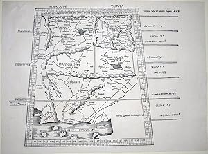
Nona Asiae Tabula.
Edité par Strassburg: Johann Schott 1513., 1513
Vendeur : Arader Galleries - AraderNYC, New York, NY, Etats-Unis
Evaluation du vendeur :
Single sheet (17 4/8 x 23 2/8 inches). FINE woodcut map of Pakistan, northwest India, showing the Ganges, Indus rivers, by Martin Waldseemüller (central vertical fold, tiny worn holes near the Indus dela). From the first modern atlas: "Geographie opus nouissima traductione e Grecorum archetypis castigatissime pressum", prepared by Martin Waldseemuller using the translation of Mathias Ringmann. One of the most important editions of Ptolemy, it contained many new regional maps based on contemporary knowledge "unlike many of the alleged 'new' maps produced by earlier editors, [they] contained a great deal of new information, and in nearly every case they were decided improvements over anything that had been previously offered." ("The World Encompassed", 56), were included in addition to the traditional body of twenty-seven Ptolemaic maps derived from the 1482 Ulm edition (or possibly from the manuscript atlas of Nicolaus Germanus that served as source for the latter). Schott's edition while initiated by the most famous of all early sixteenth-century cosmographers, Martin Waldseemuller and his associate Mathias Ringmann, partly at the expense of Duke Rene of Lorraine, was brought to completion by Jacobus Eszler and Georgius Ubelin. Claudius Ptolemy was an Alexandrine Greek, and a dominant figure in both astronomy and geography for more than 1500 years. "He compiled a mapmaker's manual usually referred to simply as the 'Geography'. He demonstrated how the globe could be projected on a plane surface, provided coordinates for over 8,000 places across his the Roman world, and expressed them in degrees of longitude and latitude. No maps drawn by Ptolemy himself are known to survive, but maps compiled from his instructions as outlined in his 'Geography' were circulated from about 1300.
-
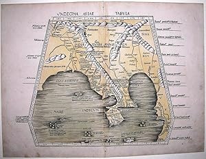
Undecima Asiae Tabula
Edité par Strassburg: Johann Schott 1513., 1513
Vendeur : Arader Galleries - AraderNYC, New York, NY, Etats-Unis
Evaluation du vendeur :
Single sheet (17 4/8 x 23 inches). FINE woodcut map of India, by Martin Waldseemüller, WITH ORIGINAL HAND-COLOUR wash in full, and as such EXCEPTIONALLY RARE, showing the entire region of southeast Asia, Bangladesh, Burma, India, the Malay Peninsula and Thailand, with the Ganges River in the west, "Sina" (China) in the east, and southeast Asia, the Indian Ocean, and China Sea (central vertical fold strengthened on the verso with archival tissue). From the first modern atlas: "Geographie opus nouissima traductione e Grecorum archetypis castigatissime pressum", prepared by Martin Waldseemuller using the translation of Mathias Ringmann. One of the most important editions of Ptolemy, it contained many new regional maps based on contemporary knowledge "unlike many of the alleged 'new' maps produced by earlier editors, [they] contained a great deal of new information, and in nearly every case they were decided improvements over anything that had been previously offered." ("The World Encompassed", 56), were included in addition to the traditional body of twenty-seven Ptolemaic maps derived from the 1482 Ulm edition (or possibly from the manuscript atlas of Nicolaus Germanus that served as source for the latter). Schott's edition while initiated by the most famous of all early sixteenth-century cosmographers, Martin Waldseemuller and his associate Mathias Ringmann, partly at the expense of Duke Rene of Lorraine, was brought to completion by Jacobus Eszler and Georgius Ubelin. Claudius Ptolemy was an Alexandrine Greek, and a dominant figure in both astronomy and geography for more than 1500 years. "He compiled a mapmaker's manual usually referred to simply as the 'Geography'. He demonstrated how the globe could be projected on a plane surface, provided coordinates for over 8,000 places across his the Roman world, and expressed them in degrees of longitude and latitude. No maps drawn by Ptolemy himself are known to survive, but maps compiled from his instructions as outlined in his 'Geography' were circulated from about 1300.
-
Relationi universali. Novamente reviste, corrette, & ampliate.
Edité par Brescia, Compagnia Bresciana, (1599)., 1599
Vendeur : Matthaeus Truppe Antiquariat, Graz, Autriche
Membre d'association : ILAB VDAO
Evaluation du vendeur :
Livre Edition originale
4 Teile in 1 Bd. 24 Bll. (letztes weiß), 536 S., 4 Bll., 227 S., 6 Bll., 268 S., 4 Blm., 112 S. mit 1 Kupfertitel und 111 Kupferkarten im Text. EDIT 16 CNCE 7301. IA 122.744. Adams B 2559. Borba de Moraes I, 114: "For more than a century considered the best geography in existence". - Die erste Ausgabe war 1592 erschienen, die vorliegende Ausgabe erstmals mit den schönen Karten aus der ersten italienischen Ausgabe der Epitome des Ortelius (Brescia 1598) ausgestattet, darunter 3 Erdteilkarten und 12 Karten verschiedener Inseln (u. a. Zypern, Malta und Sizilien). - "The work marks the beginning of demographic studies" (Wikipedia Abruf vom 13.12.2016). - Giovanni Botero (1544 - 1617) wurde von Schumpeter als "the originator of modern population theory" (Schumpeter, Geschichte. Bd. 1. S. 326) und seine "Allgemeine Historische Weltbeschreibung" ist in diesem Zusammenhang sein bedeutendstes Werk. - ". Dagegen stellen Boteros `Relationi universali` in ihrer ganzen Anlage einen großangelegten Vergleich der Staaten der Welt dar. Dieser basiert auf klaren theoretischen Vorannahmen zu den Vor- und Nachteilen von Lage, Klima oder Bodenbeschaffenheit, also den natürlichen Gegebenheiten die jeden Staat einzeln charakterisieren. Das Referenzsystem dringt immer wieder explizit durch, wenn Botero an einem Einzelfall einen typischen Zusammenhang erläutert. Die `Relationi` sind in mehrere Teile unterteilt, die zwischen 1591 und 1596 in Rom erschienen. Alle gehören zum gleichen Projekt, in Inhalt und Ausrichtung setzte sie sich voneinander ab. Der erste Teil behandelt die geographisch determinierten Länder der Welt, nach ihrer Lage, den Flüssen, Gebirgen, Städten und Landschaften, immer wieder einschließlich der Bevölkerungszahlen. Der zweite enthält häufig die gleichen Informationen noch einmal, diesmal aber nach politischen Einheiten geordnet und immer in direktem Bezug zur Macht des jeweiligen Regenten gesetzt. . Der dritte Teil beschäftigt sich mit Ausbreitung und Verteilung der Religionen der Welt, während der vierte und letzte Teil ausschließlich die Religionen der amerikanischen Indianer und deren Konversion zum Christentum beinhaltet" (Justus Nipperdey, Die Erfindung der Bevölkerungspolitik. Göttingen 2012. S. 65 ff). - Vorderes Innengelenk restauriert, Titel verso und letztes Textblatt mit Besitzvermerk, Buchblock gegen Ende des ersten Teils aufgebrochen, gebräunt, fleckig und stellenw. wasserrandig. *** *** Copyright: Matthaeus TRUPPE Buchhandlung & Antiquariat - Stubenberggasse 7 - A-8010 Graz - ++43 (0)316 - 829552 *** *** Sprache: Deutsch Gewicht in Gramm: 1500 8°. Pgmt. der Zeit (fleckig und berieben, etw. wellig).
-
(Stolen)Nona Euro Pe Tabula
Edité par Martin Waldseemuller c. 1513, Strasburg, 1513
Vendeur : Alexandre Antique Prints, Maps & Books, Toronto, ON, Canada
Membre d'association : ABAC ILAB
Evaluation du vendeur :
Carte
Etat : Excellent. (Stolen)A fine and strong impression of this rare map of Eastern Europe from the 1513 edition of Waldseemüller's modern atlas Geographia.The verso is blank. The watermark is similar to fleur de lis sitting on a multi headed star.Large Ptolemaic map depicting Europe and Balkan from the Adriatic Sea to the Black Sea.The Atlas ' GEOGRAPHIE OPUS NOVISSIMA TRADUCTIONE E GRECORUM ARCHETYPIS ' one of the most important edition of Ptolemy Atlases.was published by Johannes Schott in Strasburg 1513., Size : 434x618 (mm), 17.09x24.33 (Inches), Black & White.
-
![Image du vendeur pour Parvum theatrum urbium, Das ist: Erster Anblick, und Summarischer Außzug, von Erbawung unnd Ankunfft namhaffter Stätt, Schlösser und Klöster [.]: Sampt Angehenckten Namen, fürnemer Teutschen Völckern, ihrer Handthierung, Wassern, Bergen, Müntzen und Jahrmärckten [.]. mis en vente par Versandantiquariat Wolfgang Friebes](https://pictures.abebooks.com/inventory/md/md31427023973.jpg)
Parvum theatrum urbium, Das ist: Erster Anblick, und Summarischer Außzug, von Erbawung unnd Ankunfft namhaffter Stätt, Schlösser und Klöster [.]: Sampt Angehenckten Namen, fürnemer Teutschen Völckern, ihrer Handthierung, Wassern, Bergen, Müntzen und Jahrmärckten [.].
Edité par Frankfurt a. M., (Nikolaus Basse), 1593., 1593
Vendeur : Versandantiquariat Wolfgang Friebes, Graz, Autriche
Membre d'association : ILAB VDAO
Evaluation du vendeur :
Edition originale
Etat : 0. Erste Ausgabe mit diesen zahlreichen Illustrationen. - Mit etwa halbseitigen Ansichten, teils aus der Vogelschau, u.a. von Augsburg, Braunschweig, Bremen, Breslau, Dresden, Erfurt, Frankfurt, Fulda, Hamburg, Heidelberg, Jena, Kassel, Köln, Königsberg, Landshut, Leipzig, Lübeck, Mainz, Marburg, München, Nürnberg, Regensburg, Riga, Speyer, Straßburg, Trier, Tübingen, Ulm, Wittenberg, Worms und Würzburg. Ferner Ansichten und Pläne von Basel, Genf, Genua, London, Paris, Prag, Venedig, Wien und Zürich. Der schöne Einband vorne mit dem Wappen des Hl. Römischen Reichs, sign. S. Rab, auf dem Rückendeckel das Wappen von Ernst August, Herzog zu Sachsen. Titel verso mit dem Stempel Bibliotheca Oelrichsiana". Johann Carl Oelrichs, (1722-1798) war Jurist und Historiker. Er vermachte einen großen Teil seiner Bibliothek (u.a. alle numismatischen Werke) dem Joachimsthalschen Gymnasium; seine Schriften und Sammlungen zur brandenburgischen und pommerschen Geschichte gingen an die Universität Frankfurt (Oder). - Der dekorative Einband nur leicht berieben u. bestoßen. Rückendeckel m. Ausbruch an der oberen Deckelkante (ca. 1,5 x 4,5 cm). Deckeln leicht geworfen (aufgebogen). Vorderes Vorsatzblatt m. kl. Randläsuren, das hintere fehlt. Etw. gebräunt. - Trotz des Defekts am Rückendeckel dekoratives, vollständiges Exemplar. - VD16, S 1916; BM STC, German Books 778; Fauser LXIV; Bachmann, Städtebilder, S. 13f. ge Gewicht in Gramm: 1000 8°. Titel in Rot u. Schwarz m. Holzschn.-Vignette. Mit einem Portrait u. 61 großen Holzschn.-Städteansichten im Text. 16 Bll., 421 (1) S., 5 Bll., Blindgepr. Schweinsldr.-Bd. über Holzdeckeln a. 4 Bünden, beids. m. großen Wappensupralibros (sign. S. Rab).
-
Scholastica historia.
Edité par Straßburg, [Georg Husner], 15. Juli 1500., 1500
Vendeur : Versandantiquariat Wolfgang Friebes, Graz, Autriche
Membre d'association : ILAB VDAO
Evaluation du vendeur :
Etat : 0. Der Verfasser (um 1100-1178) war ein französischer Theologe und gehörte seit 1160 zum Domkapitel von Notre-Dame in Paris. Seine Historia Scholastica" ist eine Art biblisches Lehrbuch der Weltgeschichte und schöpft neben der Bibel auch aus Schriften weltlicher Autoren, insbesondere Flavius Josephus. Hinweise aus Geographie, Kosmologie, Philosophie, Theologie, Etymologie usw. bilden einen Kommentar zur Heiligen Schrift. - Einband etw. berieben. Rücken fachm. restauriert. Exlibris ( Philosophia Hermetica") u. kl. älterer Katalogausschnitt am Innendeckel. Titel m. fachm. ergänztem Eckabschnitt u. kl. hinterlegtem Löchlein durch entfernten Besitzvermerk (jeweils ohne Textverlust). Kopfsteg etw. knapp beschnitten (Kapitelüberschriften vereinzelt angeschnitten). Vereinzelt wasserrandig bzw. leicht fleckig. - GW M32180; Hain 5538; Goff P466; BSB-Ink P-307; BMC I, 163; Pellechet 3883; Proctor 749; ISTC ip00466000. la Gewicht in Gramm: 1000 4°. Mit 2 großen eingemalten Initialen in Rot u. Blau sowie zahlr. dreizeiligen Initialen in Rot. 207 nn. Bll. (ohne das letzte weiße; Got. Typ., 2 Kol., 51 Zeilen), Ldr. d. 18. Jahrhunderts a. 5 Bünden m. blindgepr. Deckelfileten, goldgepr. Rückentitel u. dreiseitig gespränkeltem Rotschnitt.
-
![Image du vendeur pour SEPTIMA EUROPE TABULA [SARDINIA AND SICILY] mis en vente par Pingel Rare Books](https://pictures.abebooks.com/inventory/md/md30898121786.jpg)
SEPTIMA EUROPE TABULA [SARDINIA AND SICILY]
Edité par Johann Schott, Strasbourg, 1513
Etat : Trčs bon. Rarissimeédition de 1513 de la carte de Sardaigne et Sicile de Ptolomée en coloris d'époque. Cette belle carte ptolémaďque gravée sur double page est tirée des éditions d'Ulm de 1482 et 1486. Elle a été imprimée ŕ partir de nouvelles planches pour l'édition de 1513.L'édition Geographiae 1513 de Ptolémée, la plus importante selon Stevens, est considérée comme le premier atlas moderne (World encompassed n°56) : un véritable atlas moderne est pour la premičre fois juxtaposé ŕ celui de Ptolémée, offrant une comparaison aisée entre cartes anciennes et nouvelles. Ainsi aux 27 cartes de Ptolémée sont ajoutées les 20 cartes de Martin Waldseemüller.Contexte historique : René d'Anjou, Pair de France, roi de Naples, roi titulaire de Sicile et Jérusalem, mécčne et bibliophile parlait l'italien, le grec et le latin. Passionné par l'Orient, il s'intéressait ŕ l'alphabet arabe. Son petit-fils, le Duc René II de Lorraine, portait un grand intéręt pour les lettres, les arts et les sciences dont la géographie. Il créa ŕ Saint-Dié-des-Vosges en compagnie de Vautrin Lud, une école ecclésiastique sous la protection du duché de Lorraine et du Vatican. Nicolas Lud, neveu de Vautrin et secrétaire du duc, hébergea l'imprimerie qui ?uvra ŕ la propagation des travaux scientifiques (géométrie, géographie, musique.). Vers 1507, il fit venir ŕ Saint-Dié-des-Vosges Mathias Ringmann, un Alsacien professeur d'université qui avait publié ŕ Strasbourg en 1505 le récit des voyages de Vespucci (De ora Antartica). Ils furent bientôt rejoints par Martin Waldseemüller, cartographe, dessinateur-géomčtre formé ŕ Fribourg et initié ŕ l'imprimerie ŕ Bâle par son oncle. Avec Jean Basin un latiniste, ces hommes formčrent le Gymnase vosgien. Ils éditčrent en 1507 la Cosmographiae introductio, un ouvrage comprenant une grande carte du monde et un petit globe en fuseaux. Le nom America y apparaît pour la premičre fois sur une carte et un globe. Ils songčrent ŕ une réédition de la Géographie de Ptolémée qui prendrait en compte les nouvelles découvertes, et ceci, ŕ partir de manuscrits grecs. Waldsemüller se fit pręter par les Dominicains de Bâle un exemplaire provenant du cardinal de Raguse, Jean Stojkovic. Ringmann se rendit en Italie auprčs de Jean-François Pic de la Mirandole, philosophe et humaniste italien, qui lui pręta un autre manuscrit de Ptolémée. René II de Lorraine procura ŕ Waldseemüller des cartes nautiques récentes qui indiquaient les nouvelles découvertes. Malheureusement, en 1508, le duc meurt, entraînant la faillite de l'imprimerie. En 1511, Ringmann meurt lui aussi. Un "accord" avec les avocats strasbourgeois Jacob Aesler et Georg Übelin qui s'attribučrent la paternité des travaux et tentčrent de supprimer les traces de leurs prédécesseurs, permit ŕ Johann Schott d'imprimer la Géographie ŕ Strasbourg en 1513. L'édition traduit cependant les préoccupations des membres du Gymnase vosgien.Pastoureau, p.371 ; Phillips Atlases 359 ; Sabin 66478 ; Shirley 34, World Encompassed 56 ; Stevens S. 44. - VD 16, P 5207. - Adams P 2219. - BM STC, German Books S. 719. - Fairfax Murray 348 and 348A. - Alden/Landis 513/6. / Fine1513 edition of Ptolemy's map of Sardinia and Sicily in contemporary colour. This beautiful Ptolemaic map engraved on double page is taken from the Ulm editions of 1482 and 1486. It was printed from new plates for the 1513 edition.Ptolemy's Geographiae 1513, the most important edition according to Stevens, is considered to be the first modern atlas (World encompassed no. 56): a true modern atlas is for the first time juxtaposed with Ptolemy's, offering an easy comparison between old and new maps. The 27 maps of Ptolemy are supplemented by the 20 maps of Martin WaldseemüllerHistorical context:René of Anjou, Duke of Lorraine and Anjou, King of Naples, titular King of Aragon (including Sicilia) and Jerusalem. was a bibliophile who spoke Italian, Greek and Latin. His grand-son, Duke René II of Lorraine, was interested in the arts, sciences and geography.

![Image du vendeur pour De triangulis planis et sphaericis. (.) quae extructa est ŕ Ptolemeaeo & Copernico de Revolutionibus orbium caelestium. [Avec : ] - Problematum astronomicorum et geometricorum sectiones septem. [Avec :] - In Ptolemaei magnam compositionem, quam almagestum vocant, libri tredecim mis en vente par Hugues de Latude](https://pictures.abebooks.com/inventory/md/md30050208247.jpg)
![Image du vendeur pour [Image du monde. Nouvellement imprimée a Paris par Alain Lotrian]. Sensuyt lymaige du monde contenant en soy tout le Monde mis en III parties, cestassavoir , Asie, Affrique et Europe. Avec les pays, provinces et citez et les merveilleuses et diverses creatures qui sont dedans. mis en vente par JF LETENNEUR LIVRES RARES](https://pictures.abebooks.com/inventory/md/md22846645100.jpg)
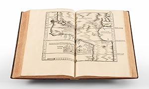
![Image du vendeur pour TABULA TERRE NOVE [THE ADMIRAL'S MAP] mis en vente par William Reese Company - Americana](https://pictures.abebooks.com/inventory/md/md31022019826.jpg)
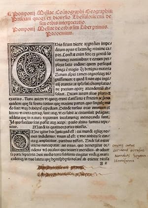
![Image du vendeur pour Cosmographia [with:] De situ orbis mis en vente par Donald A. Heald Rare Books (ABAA)](https://pictures.abebooks.com/inventory/md/md31814926085.jpg)
![Image du vendeur pour [Orient:] Leonharti Rauwolfen, der Artzney Doctorn, und bestelten Medici zu Augspurg Aigentgliche beschreibung der Raiß, so er vor dieser zeit gegen Auffgang inn die Morgenländer, fürnemlich Syriam, Iudaeam, Arabiam, Mesopotamiam, Babyloniam, Assyriam, Armeniam etc. nicht ohne geringe mühe unnd große gefahr selbs volbracht: neben vermeldung etlicher mehr gar schön frembden und außländischen Gewächsen, sampt iren mit angehenckten lebendigen contrafacturen, unnd auch anderer denckwürdiger sachen, die alle er auff solcher erkundiget, gesehen und obseruiert hat. Alles in Vier underschidliche Thail mit sonderem fleiß abgethailet, unnd ein jeden weitter in seine sondere Capitel, wie dero jnnhalt in zü: end gesetztem Register züfinden. mis en vente par Antiquariat Rolf Bulang](https://pictures.abebooks.com/inventory/md/md19134865933.jpg)
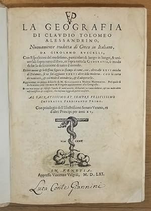
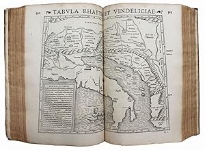
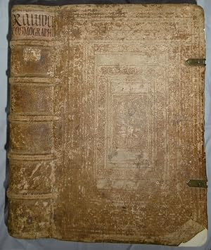
![Image du vendeur pour Moscoviter wunderbare Historien. In welcher deß treffenlichen Grossen land Reüßen, sampt der hauptstatt Moscauw, und anderer nammhafftigen umligenden Fürstenthumb und stetten gelegenheit, Religion, und seltzame gebreüch begriffen. Jetz Durch Heinrich Pantaleon verteütschet. Mit samp Pauli Jouij [d. i. Paolo Giovio] Moscouitischer landen, und Georgen Wernhern [d. i. Georg Werner] Ungarischer wunderbaren wasseren beschreibung. mis en vente par Matthaeus Truppe Antiquariat](https://pictures.abebooks.com/inventory/md/md31194167308.jpg)