Montant total (1 article articles) :
Destination de la commande :

geographie (Plus de 1 100 résultats)
Passer aux résultats principaux de la recherche
Type d'article
- Tous les types d'articles
- Livres (594)
- Magazines & Périodiques
- Bandes dessinées
- Partitions de musique
- Art, Affiches et Gravures (482)
- Photographies (1)
- Cartes (92)
-
Manuscrits &
Papiers anciens (1)
Etat
- Tous
- Neuf
- Ancien ou d'occasion
Reliure
Particularités
- Edition originale (141)
- Signé (6)
- Jaquette (3)
- Avec images (1 035)
- Sans impression ŕ la demande
Livraison gratuite
Pays
Evaluation du vendeur
-
Cartes de Geographie Les plus Nouvelles et les plus Fideles
Edité par Paris: Chez l'Auteur, 1679., 1679
Vendeur : Arader Galleries - AraderNYC, New York, NY, Etats-Unis
Evaluation du vendeur :

Edition originale
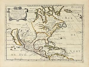
Du VAL, Pierre (1619-1683). Cartes de Geographie Les plus Nouvelles et les plus fideles, Avecque leurs Divisions Regulieres, qui marquent les Bornes des Estats selon les derniers Traites de Paix. Paris: Chez l'Auteur, 1679. Folio (17 x 12 2/8 inches). Engraved "Introduction", "Alphabet et Definition des Termes", "Table Generale de Geographie", "Les Tables de Geographie reduites en un Jeu de Cartes" and two sheets of a games related to the German Empire (uncoloured), and one of place-names for Les Conciles; engraved allegorical title-page, fine double-page engraved double-hemisphere world map "Planisphere, ou Carte Generale de Monde", "Carte Universelle du Commerce", 1677 (Shirley 465, second state), and 89 double-page engraved maps, all with original hand-colour in outline. 19th-century tree sheep backed marbled paper boards, the spine in six compartments, with five raised bands, the second with maroon morocco lettering-piece, the others decorated with fine gilt tools (extremities a little scuffed, small abrasion to lower cover). Provenance: with 19th-century marginal manuscript scholarly annotations to L'Amerique autrement le Nouveau et Indes Occidentales Du Val's EXTREMELY RARE "Cartes Geographiques" (Pastoureau Duval II), was the only folio atlas published by him. It was initially a collection of du Val's own maps, with those of other authors, published in 1654, then 1665 and 1667. In 1677 du Val published a uniform collection of his grand four-part wall, and folio maps, with the allegorical frontispiece as here: an architectural border supporting two putti unveiling a large globe to a world of assorted grandees; beneath the pillared arch repose a gentleman traveller, a merchant with this bags of salt and pepper, a scientist illuminating his own hand, and a curious woman tending to her animals. The maps in this example of the "Cartes Geographiques" are EXCEPTIONALLY FINE, bright, clean and attractive examples, with original hand-colouring in outline, and include 2 world maps, double-hemisphere and on a Mercaor projection, 7 of his spectacular wall maps, 3 sheets of games, that seem to be the equivalent of our "Risk", and 89 detailed double-page maps, each detailed, but also beautiful for their elegant simplicity. Pierre du Val was the nephew of the celebrated French cartographer Nicolas Sanson d'Abbeville (1600-1667), mapmaker to Louis XIV, King of France, and responsible for sparking a renaissance in geographical endeavor in France, and laying the foundations for French domination in map production, initiating the so-called "French school of cartography," a school that was unprecedented in its attention to precision and scientific detail and which discarded much of the decorative embellishments of previous maps as irrelevant. Du Val adopted Sanson's geographical conceptions, confirming that the center of cartographic innovation had shifted from Holland to France. Du Val too was appointed to the position of Geographe ordinaire to Louis XIV, and justifiably so. The maps include, in order: - World maps: Planisphere, ou Carte Generale de Monde (Duval II D), double-hemisphere world map, surrounded by diagrams showing compass points, winds and planetary orbits, a small terrestrial globe and an armillary sphere - Carte Universelle du Commerce, Carte Hidrographique, ou. Les Costes des 4 Parties du Monde, Avecque les Routes pour la Navigation des Indes, Occidentales et Orientales 1677 (Shirley 465, second state, first published in 1674), on Mercator s projection showing the French and English routes to and from the East and West Indies, complete with galleons in full sail, the track of Le Maire across the Pacific, and an anonymous attempt to find a route to China and Japan through Hudson s Bay in 1665. This map perpetuates the myth that California is an island, and displays some of the misunderstandings about the largely unexplored northwest coast of North America, such as the Straits of Anian. The lower half of the map is do.
-

Cartes generales de la geographie ancienne et nouvelle ou les empires, monarchies, Royaumes
Edité par Paris: The author and Pierre Mariette, 1675., 1675
Vendeur : Arader Galleries - AraderNYC, New York, NY, Etats-Unis
Evaluation du vendeur :
Edition originale
2 volumes in one. Folio (18 x 12 5/8 inches). Letterpress title-page to each volume and "Liste des Cartes", folding letterpress "Catalogues des Cartes Geographiques des Dieurs Jaillot Geographes Ordinaires du Roy" dated 1778 and with price-list in manuscript, bound at the beginning. 83 FINE folding engraved maps of the new and ancient world, with contemporary hand-colour in outline. Contemporary speckled calf (rebacked to style). First edition. Containing maps dating from 1652-1669, and particularly related to the Americas: three world maps "Harmonie ou Correspondance du Globe" (1659), "Mappemonde ou carte generale" (1669) (cf.Shirley 419), and " L'Hydrographie ou description de L'Eau" (1652) each showing California as an island, the last also one of the earliest obtainable maps to show the 5 Great Lakes; "Amerique Septentrionale" (1669), Burden's first state (404); "Le Canada, ou Nouvelle France" (1656); "Le Nouveau Mexique et la Floride" (1656), first state, engraved by Somer, and a cornerstone map of California and the Southwest, based on the Blaeu world map of 1648; "Mexicque ou Nouvelle Espagne" (1656); "Les Isles Antilles" (1656); "Amerique Meridionale" (1669); "Terre Ferme ou sont les Governations, ou Gouvernemens de Terre Ferme, Cartagene, St. Marthe, Rio De la Hache, Venezuela, Nouvelle Andaluise, Popyan" (1656); "Partie de Terre Ferme ou sont Guiane et Caribane" (1656); "Le Perou et le course de la Rivre Amazone" (1656); "Le Chili" (1669); "Le Bresil" (1656); "Le Paraguay" (1668); "Le Terre et les Isles Magellaniques" (1668). The maps were compiled by Nicolas Sanson who first published his atlas in 1654, with 100 maps, and engraved and printed by Pierre Mariette; each held the copyright to half of the maps which bear their separate imprints, and were issued progressively from 1630. Born in Abbeville, a town in the Picardy region of France, in 1600, Sanson was the most noted French cartographer in modern history. Mapmaker to Louis XIV, King of France, Sanson endowed his maps with the most recent geographical information as well as the finest and sharpest engraving of the period. His "Cartes Generales de Toutes les Parties du Monde" was the most important single product of French commercial cartography of the seventeenth century. Sanson sparked a renaissance in geographical endeavor in his native country, which had not been a major player on the international cartographic stage since the great Oronce Finé in the sixteenth century. With this atlas, Sanson laid the foundations of French domination in map production, initiating the so-called "French school of cartography," a school that was unprecedented in its attention to precision and scientific detail and discarded much of the decorative embellishments of previous maps as irrelevant. From Sanson's time in the second half of the seventeenth century until the latter part of the eighteenth century, French geographical conceptions were more influential than those put forward by any other nation. With this landmark atlas, Sanson all but single-handedly caused the center of cartographic innovation to shift from Holland to France. Philips 486. Catalogued by Kate Hunter.
-
[MANUSCRIT] Cartes particuličres par gouvernements de la province de Dauphiné
Edité par c1630-1640, 1630
Etat : Trčs bon. Oblong de 37 x 26,5 cm, vélin souple ŕ recouvrement de l'époque, dos lisse avec inscription manuscrite «Dauphiné», double encadrement des plats de simples et doubles filets dorés, fer ovale ornementé de motifs floraux poussé au centre des plats, tranches dorées.2 ff. nch, 45 cartes manuscrites:1. Carte Generalle de dauphine2. Gouvernem' de Cisteron3. Plan de Cisteron4. Gouvernemen de la Principauté dorange5. Plan de la Ville & Citadelle dorange6. Gouvern' d'avignon7. Gouverneme' du St Esprit8. Plan de la Ville & Citadelle du Pont St Esprit9. Gouvern' de Turin10. Plan de la Ville & Citadelle de Turin11. Gouvernem' de Casal & de Trin12. Plan de Cazal13. Plan de la Ville & Citadelle de Trin14. Gouverne' de Milan15. Plan de la Citadelle de Milan16. Gouvernement d'embrun17. Plan d'ambrun18. Gouvernement de Puimore19. Plan de Puimore20. Gouvernem' du Pas de Lescluze21. Plan du Pas de Lescluze22. Gouvern' de Montlimar23. Plan de Montlimar24. Gouverneme' de Pignerol & de Briqueiras & la Perouze fort stebregide25. Plan de Pignerol26. Plan du fort Saincte Bregide27. Plan du Fort de la Perouze28. Plan de la Ville & chau' [château] de Briqueiras29. Gouvern' de Valance30. Plan de Valance31. Gouverne' du Chasteau dčxille & Gelasse32. Carte Particulliere des Environs de Suze33. Plan du Chasteau dexille34. Plan du fort de Gelasse35. Gouvern' de Grenoble36. Plan de la Ville & Citadelle de Grenoble37. Gouvernement du Fort de Baraus & Montmelian 38. Plan du Fort de Barrault39. Plan de la Ville & Citadelle de Montmelian40. Gouverne' de Quirieu41. Plan de Quirieu42. Gouverneme' de Bourg en Bresse43. Plan de la Ville & Citadelle de Bourg en Bresse44. Gouvern' de Genesue [Genčve]45. Plan de la Ville & Citadelle de Genesue [Genčve]La cartographie du territoire français a été un enjeu primordial ŕ l'époque moderne comme en témoigne le géographe Nicolas de Nicollay pour qui elle devait permettre au souverain «sans grande peine de voir ŕ l'?il et toucher du doigt»[1] le royaume dans toute son étendue et sa diversité. Carrefour des Alpes et de l'Europe méridionale, la province du Dauphiné, conquise aprčs de hautes luttes par les français, est un territoire stratégique dont la géographie montagneuse est un défi non seulement pour la cartographie, la politique mais aussi la pratique des arts de la guerre. Cet atlas manuscrit militaire, d'une trčs grande rareté, cartographie cette zone dans son entičreté et représente aussi son voisinage proche de la confédération des treize cantons en passant par les Duchés de Savoie et du Milanais. Outre son intéręt géographique et administratif, la vocation guerričre de ce livre est clairement évoquée en introduction de son Explication pour l'intelligence des cartes. L'auteur précise qu'il a ajouté les «chemins par oů l'armée, et le canon, peuvent passer pour aller en Italie». De fait, cet ouvrage témoigne des fortes ambitions françaises dans cette région au début du XVIIe sičcle ainsi que d'une volonté clairement expansionniste. L'intéręt marqué de son auteur pour les environs de Suze permet de supposer que la réalisation du manuscrit est postérieure ŕ la bataille du 6 mars 1629 oů s'imposčrent les troupes françaises de Louis XIII. Visiblement peu concerné par la représentation de la déclivité de cette région, le cartographe ayant réalisé cet ensemble s'est surtout s'intéressé aux frontičres, aux voies de communication et ŕ la toponymie alpestre.Au regard du savoir et des informations dispensées dans l'ensemble de ce manuscrit, Christophe Tassin semble ętre une des rares personnes ŕ avoir pu accéder ŕ une telle masse de connaissances dont la carte secrčte réalisée par Jean de Beins en 1617[2]. Nous proposons donc de lui attribuer cet atlas. Ingénieur et géographe du roi, ce cartographe «est surtout célčbre pour ses petits atlas oblongs», il entretient aussi des «rapports étroits avec le milieu des éditeurs de carte» selon Mireille Pastoureau[3]. Son ?uvre gravé a été édité par cinq libraire: Melchior Tavernier, Jean Mes.
-
I. Geographiae libri octo, recognitiam diligenter. [II. Galliae Tabule Geographicae. Belgii Inferiores Geographicae Tabule].
Edité par Cologne, Gottfried von Kempen, 1584 / Duisburg, [1585-1602]. 1584, 1602
Vendeur : JF LETENNEUR LIVRES RARES, Saint Briac sur mer, France
Membre d'association : ILAB
Evaluation du vendeur :

Edition originale
3 parties en 1 vol in-folio (410 x 280 mm) de: [2] ff. (titre gravé et enluminé et feuillet préliminaire) ; 106 pp. (nombreux schémas dans le texte) ; [16] ff. (index, 1 tableau sur pleine page) ; [5] ff. (f. blanc, titre, privilčge et schéma gravé sur pleine page) ; 27 cartes sur double page en beaux coloris d'époque avec description de chacune au dos ; 1 carte dépliante avec description ; [15] ff. (index) ; [10] ff. (titre gravé, privilčge, avis au lecteur et index) ; 23 cartes sur double page avec description de chacune au dos ; 1 carte ŕ pleine page avec description. (Rares traces de mouillures, corps d'ouvrage frais). Plein veau XVIIe, dos ŕ nerfs orné, titre de maroquin rouge, roulette dorée sur les coupes, tranches jaspées rouges. (Discrčtes restaurations aux coiffes et aux coins) Premičre édition avec la traduction de la géographie de Ptolémée par Pirckheimer, éditée par Arnold Mylius, exemplaire avec 28 cartes en superbes coloris d époque. Gerard Mercator (1512-1594), surnommé par Ortelius "le Ptolémée de notre temps", gravait ces plaques de cuivre dans le cadre d'une cosmographie qu'il comptait publier en cinq volumes. Le temps et l'effort mis par Mercator dans sa révision de Geographia de Ptolémée faisaient partie d'un grand projet qui occupa la plus grande partie de sa vie. Mercator avait pour projet de produire un ouvrage donnant la géographie et l histoire des mondes antique et moderne. Sa carte générale Ptolémaďque est l'une des plus belles jamais produite. Les plaques de Mercator étaient si parfaites que 7 autres éditions en seront tirées. Adams P-2232; Sabin 66490; Koeman Me2; Shirley 139. 3 parts in 1 vol in-folio of: [2] ff. ; 106 pp. ; [16] ff. ; [5] ff. ; 27 maps on double page in beautiful period colors with description of each one on the back; 1 folding card with description; [15] ff. ; [10] ff. ; 23 maps on double page with description of each one on the back; 1 full-page map with description. 17th century calf, decorated ribbed spine, red morocco title, gilt roulette on the cuts, red marbled edges. (Discreet restorations to the caps and corners). First edition, with the translation of the geography of Ptolemy by Pirckheimer, edited by Arnold Mylius, copy with the 27 maps in beautiful contemporary colors. Gerard Mercator (1512-1594), named by Ortelius "the Ptolemy of our time", engraved these copper-plates as part of a cosmography that he intended to publish in five volumes. Mercator's time and effort in revising Ptolemy's Geographia was part of a larger project that occupied most of his life. Mercator's plan was to produce a work on the geography and history of the ancient and modern worlds. His general Ptolemaic map is one of the most beautiful ever produced. The plates of Mercator were so perfect that 7 other editions were made with them. [bound with Mecator Galliae Tabule Geographicae. 24 engraved maps].
-
Philippi Cluveri Italia Antiqua; Opus post omnium curas elaboratissimum; tabulis geographicis aere expressis illustratum. Ejusdem Sicilia, Sardinia et Corsica. Cum Indice locupletissimo.
Edité par ex officina Elzeviri 1619-1624, Lugduni Batavorum, 1619
Edition originale
Ensemble 2 ouvrages reliés en 2 forts volumes grand in-4, reliures pleine truie ornées d'un décor estampé ŕ froid sur les plats et le dos ŕ nerfs; doublures et gardes de papier ancien crčme, tranches lisses (reliures de l'époque).Cette édition originale de Italia Antiqua est illustrée de 15 cartes sur double page. Chef d' uvre du géographe hollandais Philippi Cluwer, l'ouvrage est considéré comme une des meilleures publications consacrées ŕ la géographie de l'Italie ancienne et de ses alentours, non seulement pour la qualité de ses cartes, mais aussi pour l'érudition de ses notices qui traitent męme de l'aspect toponymique et historique. On appréciera en particulier des descriptions de la Ligurie, de la Corse et du sud-est de la France (Nice, Monaco, La Turbie, etc.). C'est le seul ouvrage terminé et complet écrit par Philippi Cluwer, qui lui a demandé un an de voyage (entrepris aux frais de l'académie de Leyde).A la suite a été reliée l'édition originale de Siciliae Antiquae, illustrée de 5 cartes gravées également sur double page.La réunion de ces deux ouvrages est rarissime.
-
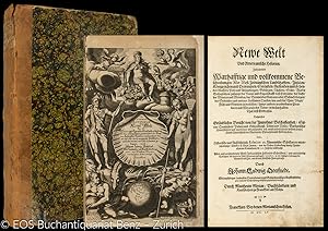
Die Unbekante Neue Welt, oder Beschreibung des Welt-teils Amerika, und des Sud-Landes: Darinnen vom Uhrsprunge der Ameriker und Sudländer, und von den gedenckwürdigen Reysen der Europer darnach zu. Wie auch Von derselben Festen Ländern, Inseln, Städten, Festungen, Dörfern . und so wohl alten als neuen Kriegen, ausführlich gehandelt wird; Durch und durch mit vielen nach dem Leben in Ameriken selbst entworfenen Abbildungen gezieret. Durch O(lfert) D(apper übersetzt).
Edité par Amsterdam, Meurs,, 1673
Vendeur : Matthaeus Truppe Antiquariat, Graz, Autriche
Membre d'association : ILAB VDAO
Evaluation du vendeur :
Livre Edition originale
3 Bll., 658 S., 11 Bll. mit ca. 70 Textkupfern. 1 Kupfertitel, 16 (1 gefalt.) Kupferkarten, 6 Kupfer-Porträts und 32 (meist gefalt. oder doppelblattgr.) Kupfertafeln. Erste deutsche Ausgabe. - VD17 3:307896S. Borba de Moraes I, 206f. Howes D 59. Tiele 763 Anm. Sabin 50087: ". much scarcer than the Dutch original". - "This is a classic book on America, and is much sought after by collectors of Americana as it contains one of the first views of New York during the Dutch period. It is searched for with no less eagerness by Brazilians for it is a classic on the Dutch period." (Borba de M. II, 77). - Arnold Montanus (auch Arnold van den Berghe; 1625 - 1683) war ein niederländischer Theologe und Historiker. Er verfasste zahlreiche historische Abhandlungen, die sich mit den Völkern und der Kultur der Neuen Welt und der Geschichte der Niederländer in Übersee befassen. Obwohl er selbst Europa nie verlassen hat, wurden seine Bücher zu Standardwerken, besonders "De Nieuwe en Onbekende Weereld" ist eine reiche Fundgrube zur Geschichte Amerikas des 16. und 17. Jahrhunderts. Die vorliegende erste deutsche Ausgabe dieses Werkes wurde vom niederländischen Arzt Olfert Dapper übersetzt und erweitert. - Die mindestens doppelblattgroßen Tafeln zeigen Ansichten der wichtigen Städte u. Häfen der Neuen Welt, darunter Acapulco, Bahia, Havanna, Neu Mexico, Lima, Potosi u. a., im Text meist Kostüme, Tiere u. Pflanzen sowie weitere Ansichten, darunter Neu-Amsterdam. - Unter den Karten Neu-Belgien mit Manhattan, Neu-Spanien (Mexiko), Venezuela, Brasilien u. Feuerland. - Die eindrucksvollen Porträts u. a. von Kolumbus, Montezuma, Magellan. Mit der öfters fehlenden großen Karte von Amerika. - Titel mit hinterlegter Fehlstelle. Die Tafel "Alagoa ad Austrum" (S. 494) mit kl. Fehlstellen durch Rasur auf der Hinterseite. Leicht gebräunt, kaum fleckig. Vereinzelt im unteren weißen Rand angerandet. *** *** Copyright: Matthaeus TRUPPE Buchhandlung & Antiquariat - Stubenberggasse 7 - A-8010 Graz - ++43 (0)316 - 829552 *** *** Sprache: Deutsch Gewicht in Gramm: 0 4°. Mod. Ldr. unter Verwendung von wenigen Resten des alten Rückens (leicht berieben).
-
Die Ehre Deß Hertzogthums Crain: Das ist . Belegen- und Beschaffenheit dieses . Römisch-Kayserlichen Erblandes. . In reines Teutsch gebracht . und erweitert durch Erasmus Francisci.
Edité par Laibach und Nürnberg, Endter,, 1689
Vendeur : Matthaeus Truppe Antiquariat, Graz, Autriche
Membre d'association : ILAB VDAO
Evaluation du vendeur :
Livre Edition originale
4 Bde. Mit über 500 Textkupfern. 1 Frontisp., 1 Porträt, 4 doppelblattgr. Karten und 18 (davon 1 vierblattgr. und 11 doppelblattgr.) Tafeln (alles in Kupferstich) sowie 1 doppelblattgr. Tabelle. Erste Ausgabe des wichtigsten Werkes zur krainerischen bzw. slowenischen Geschichte und Topographie. - VD17 23:266828Z. Nebehay/W. 766. - Johann Weichard von Valvasor (slowen. Janez Vajkard Valvasor; 1641 - 1693) besuchte die jesuitische Lateinschule in Laibach, nahm am Türkenfeldzug 1663/64 teil und bereiste längere Zeit Frankreich, Italien und Afrika. Auf Schloß Wagensberg, wo er seit 1672 lebte, sammelte er Bücher, Graphiken, Münzen und Instrumente und eröffnete 1678 eine Kupferstecherei. Als Viertelhauptmann führte er 1683 krainische Truppen gegen die Türken. 1687 wurde Valvasor in die Royal Society aufgenommen. Als Buchkünstler schuf er zusammen mit anderen ein Bildbuch zur Passion Christi (Dominicae passionis icones, 1679) und ein "Theatrum mortis humanae (3 Tle., 1682)". "Baron Johann Weichert Valvasor realised his country was very little known abroad, and he set out to present it in words and pictures, writing descriptions of Carniola, Carinthia and Istria, and setting up a copper engraving and printing workshop at Bogensperk . Here he wrote two of his most famous works in 1679 the "Topographia ductatus Carniolae modernae", an album of 320 engravings of towns, market towns, monasteries and castles in Carniola, with an index in both German and Slovenian. The second was The Glory [in Praise] of the Duchy of Carniola (Die Ehre dess Hertzogthums Crain) originally written in German and published in Nuremberg in 1689. This was the first systematic overview of the history, territory and way of life of Carniola and nearby regions". (royalsociety-org). - Ein großer Teil der Ansichten wurde dem 1679 erschienen Werk Valvasor "Topographia Ducatus Carniolae modernae" übernommen, jedoch zumeist dem Hochformat neu angepaßt, indem die Platten seitlich verkleinert wurden. Andere Kupferplatten wurden aber neu gestochen. Die neuen Platten sind feiner und haben keine zweisprachige Beschriftung. Neben den topographischen Ansichten weist das Werk auch Landkarten und zahlreiche historische kostumkundliche und folkloristische Darstellungen auf. - Es fehlt die S. 1/2 (Titel) in Bd. 2. - Etw. gebräunt und fleckig. Wenige kl. teils hinterlegte Randläsuren (meist ohne Textberührung). Die doppelblattgr. tafeln teils mit Randeinrissen (teils geringer Verlust). *** *** Copyright: Matthaeus TRUPPE Buchhandlung & Antiquariat - Stubenberggasse 7 - A-8010 Graz - ++43 (0)316 - 829552 *** *** Sprache: Deutsch Gewicht in Gramm: 10200 4°. Pgmt. der Zeit (etw. bestoßen und fleckig).
-
L Europe en Plusiers Cartes, et en divers Traites de Geographie et d Histoire;. ses Empires, ses Peuples, ses Colonies, leurs Moeurs, Langues, Religions, Richesses,
Edité par Paris: Chez l Autheur, 1683., 1683
Vendeur : Arader Galleries - AraderNYC, New York, NY, Etats-Unis
Evaluation du vendeur :
"4 parts in one volume. 4to., (8 4/8 x 7 5/8 inches). Four letterpress title-pages, including one general title-page, four indexes (lacking double-page engraved title-page). 62 engraved double-page or folding maps, 14 with later hand-colour in outline (one or two with archival repairs to folds on versos, some inoffensive waterstaining to last few maps). Late 18th-century half calf, marbled paper boards, citron morocco lettering-piece on spine (corners worn, rubbed, hinges weak). Sanson s series of quarto atlases were originally published separately as "L Europe" in 1648 by Sanson s son, also Nicholas, who was tragically killed in the "Barricades" insurrection the same year, "L Asie" in 1652, "L Afrique" in 1656, and "L Amerique" 1657. The maps of America include: "Amerique Septentrionale", "Canada, ou Nouvelle France", "La Floride", "Mexico", Guadalajara", "Guatimala", "Les Isles Antilees", "Amerique MEridionale", "Terre Ferme de Grenade", "Guiane", "Le Perou", "Le Chili", "Le Bresil", "Le Paraguay" "Detroit de Magellan". Sanson published his first folio atlas in 1654, with 100 maps, engraved and printed by Pierre Mariette; each held the copyright to half of the maps which bear their separate imprints, and were issued progressively from 1630. Born in Abbeville, a town in the Picardy region of France, in 1600, Sanson was the most noted French cartographer in modern history. Mapmaker to Louis XIV, King of France, Sanson endowed his maps with the most recent geographical information as well as the finest and sharpest engraving of the period. His "Cartes Generales de Toutes les Parties du Monde" was the most important single product of French commercial cartography of the seventeenth century. Sanson sparked a renaissance in geographical endeavor in his native country, which had not been a major player on the international cartographic stage since the great Oronce Finé in the sixteenth century. With this atlas, Sanson laid the foundations of French domination in map production, initiating the so-called "French school of cartography," a school that was unprecedented in its attention to precision and scientific detail and discarded much of the decorative embellishments of previous maps as irrelevant. From Sanson's time in the second half of the seventeenth century until the latter part of the eighteenth century, French geographical conceptions were more influential than those put forward by any other nation. Phillips 494, Sabin 76712n; Shirley T.San 3a, 4a, 5a, 6a. Catalogued by Kate Hunter.".
-
L Europe en Plusiers Cartes, et en divers Traites de Geographie et d Histoire;. ses Empires, ses Peuples, ses Colonies, leurs Moeurs, Langues, Religions, Richesses,
Edité par Paris: Chez l Autheur, 1683., 1683
Vendeur : Arader Galleries - AraderNYC, New York, NY, Etats-Unis
Evaluation du vendeur :
"4 parts in one volume. 4to., (8 5/8 x 6 5/8 inches). Four letterpress title-pages, including one general title-page, four indexes. 62 engraved double-page or folding maps (maps of Italy and Turkey laid down to adjoining text leaves, some light soiling and spotting). Contemporary mottled calf (worn, joints weak). Provenance: with early ownership inscription of Joseph Bromehead (?1748-1826), writer of hymns, and curate of Eckington Derbyshire, on the title-page; and the early 20th-century inscription of "The Rentzes, Cairo, 8.1.53" on the recto of the first blank. Sanson s series of quarto atlases were originally published separately as "L Europe" in 1648 by Sanson s son, also Nicholas, who was tragically killed in the "Barricades" insurrection the same year, "L Asie" in 1652, "L Afrique" in 1656, and "L Amerique" 1657. The maps of America include: "Amerique Septentrionale", "Canada, ou Nouvelle France", "La Floride", "Mexico", Guadalajara", "Guatimala", "Les Isles Antilees", "Amerique MEridionale", "Terre Ferme de Grenade", "Guiane", "Le Perou", "Le Chili", "Le Bresil", "Le Paraguay" "Detroit de Magellan". Sanson published his first folio atlas in 1654, with 100 maps, engraved and printed by Pierre Mariette; each held the copyright to half of the maps which bear their separate imprints, and were issued progressively from 1630. Born in Abbeville, a town in the Picardy region of France, in 1600, Sanson was the most noted French cartographer in modern history. Mapmaker to Louis XIV, King of France, Sanson endowed his maps with the most recent geographical information as well as the finest and sharpest engraving of the period. His "Cartes Generales de Toutes les Parties du Monde" was the most important single product of French commercial cartography of the seventeenth century. Sanson sparked a renaissance in geographical endeavor in his native country, which had not been a major player on the international cartographic stage since the great Oronce Finé in the sixteenth century. With this atlas, Sanson laid the foundations of French domination in map production, initiating the so-called "French school of cartography," a school that was unprecedented in its attention to precision and scientific detail and discarded much of the decorative embellishments of previous maps as irrelevant. From Sanson's time in the second half of the seventeenth century until the latter part of the eighteenth century, French geographical conceptions were more influential than those put forward by any other nation. Phillips 494, Sabin 76712n; Shirley T.San 3a, 4a, 5a, 6a. Catalogued by Kate Hunter.".
-
Description de tout l'Univers, en plusieurs Cartes, & en divers Traitez de Geographie et d'Histoire.
Edité par Amsterdam: François Halma, 1700., 1700
Vendeur : Arader Galleries - AraderNYC, New York, NY, Etats-Unis
Evaluation du vendeur :
Edition originale
8vo., (9 x 7 Ľ inches). Hand-colored vignette title page printed in two colors, sectional title pages, hand-colored woodblock historiated initial letters, "Message to the Bookbinder" in Dutch and French at end (this copy without the double-page allegorical title page; upper half of pp. 1/2 of Bion cut away). 71 (of 74) double-page maps with hand color in full, heightened with liquid gold, 10 (of 15) plates, 8 of these folding (some pale stains). Contemporary mottled calf, the spine in six compartment separated by five raised bands, gilt lettered in one and decorated in the rest (hinges starting, gilt lettering faded, extremities worn). Provenance: Probably from the library of Andrew Dury (fl. mid-18th century), mapmaker and publisher, his widow's sale 1787. With extensive contemporary manuscript annotations throughout by Charles Skottowe, Hinsale, including the note "This book was bought at Mrs. Dury's Auction, for 101 by Chas. Skottowe Nov 8 1787" on verso of title page. With manuscript ownership inscription of "J. F. Mournan, 1st May 1887, Springmount Hallow" to sectional title page of Africa section. Freeman's, 1/21/2005, Lot 203. First edition. Pocket atlas published by François Halma, the maps reduced from Sanson's 1658 folio atlas, with Luyt's Tables Geographiques & Bion's l'Usage des Globes, featuring striking folding plates diagramming the workings of the celestial systems. Without the world map, the map of southern Germany, and the map of Madagascar. Born in Abbeville, a town in the Picardy region of France, in 1600, Sanson was the most noted French cartographer in modern history. Mapmaker to Louis XIV, King of France, Sanson endowed his maps with the most recent geographical information as well as the finest and sharpest engraving of the period. His "Cartes Generales de Toutes les Parties du Monde" was the most important single product of French commercial cartography of the seventeenth century. Sanson sparked a renaissance in geographical endeavor in his native country, which had not been a major player on the international cartographic stage since the great Oronce Finé in the sixteenth century. With this atlas, Sanson laid the foundations of French domination in map production, initiating the so-called "French school of cartography," a school that was unprecedented in its attention to precision and scientific detail and discarded much of the decorative embellishments of previous maps as irrelevant. From Sanson's time in the second half of the seventeenth century until the latter part of the eighteenth century, French geographical conceptions were more influential than those put forward by any other nation. With this landmark atlas, Sanson all but single-handedly caused the center of cartographic innovation to shift from Holland to France. Although this atlas is always listed under Nicolas Sanson, it is essentially Francois Halma's plagiarized pocket version of the Sanson atlas, reduced from Sanson's 1658 folio atlas, with the map divided into Continent groups. "François Halma was an editor, printer and publisher of theological, historical and geographical works. His output was large. He first established his business in Utrecht in 1674, then moved to Amsterdam and finally settled in Leeuwarden where he died in 1722. Among his works was an edition of Mercator's Ptolemy (1695) and a reduced-size edition of Sanson's large atlas under the new title 'Description De Tout L'Univers' [as here]" (Shirley, Printed Maps of the British Isles 1650-1750, p. 66). Koeman II, Hal1; Phillips, Atlases 528; Shirley Pastoureau, Sanson VII G.
-
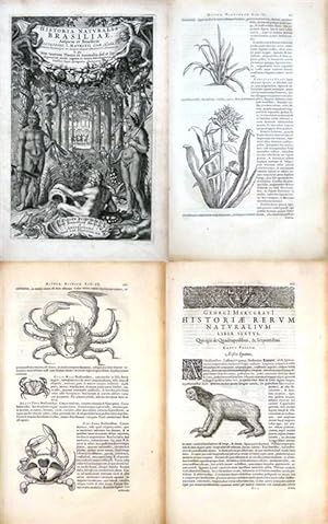
Historia naturalis Brasiliae. in qua non tantum Plantae et Animalia sed et Indigenarum morbi, ingenia et mores describuntur.
Edité par Leiden, Fr. Hack und Amsterdam, L. Elzevier., 1648
Vendeur : Antiquariat im Hufelandhaus GmbH vormals Lange & Springer, Berlin, Allemagne
Membre d'association : GIAQ ILAB VDA
Evaluation du vendeur :
Edition originale
2 Teile in 1 Bd. Folio. Kupfertitel, 429 Planzen- und Tierholzschnitte, (5 Bl.), 122 S., (1 Bl.) - (4 Bl.), 293 S., (3 Bl.). Pergamentband der Zeit (etwas fleckig) mit handschriftlichem Rückentitel (stellenweise verblasst). Erste Ausgabe dieser frühen Naturgeschichte Brasiliens in einem schönen Exemplar. - Sabin 63028; Borba de Moraes II, 152; Bosch 109; Willems 1068; Nissen, Botan. Buchillustr. 1533. - "Die Historia naturalis Brasiliae vereinigt in sich die ersten exakten wissenschaftlichen Forschungsberichte über die Naturgeschichte, Geographie, Metereologie und Ethnologie Brasiliens. Sie blieb das naturgeschichtliche Standardwerk bis Anfang des 19. Jahrhunderts, als Maximilian Prinz zu Wied-Neuwied, Spix und Martius ihre Arbeiten veröffentlichten" (B.). - "The only illustrated work about Brazilian natural history. Luxuriously printed by Elzevier, it is one of the beautiful Dutch works on Braziliana" (B.d.M.). - Enthält im ersten Teil Pisos "De medicina Brasiliensi libri quattuor", im zweiten von Marcgraf "Historiae rerum naturalium Brasiliae libri octo". - Das 8. Kapitel dieses zweiten Teiles, hrsg. v. J. de Laet, behandelt die Geographie, Ethnologie und Meteorologie. Es enthält zudem einen Auszug aus der brasilianischen Grammatik des P. Joseph de Anchieta und ein brasilianisch-lateinisches Wörterverzeichnis von E. de Moraes. - Die schönen Textholzschnitte, meist nach Zeichnungen Marcgrafs, zeigen Pflanzen, Säugetiere, Fische, Insekten sowie Eingeborene und Darstellungen der Zucker-, bzw. Kassavebrotherstellung. - Ein breitrandiges und sehr sauberes Exemplar. Die Innenseite des Vorderdeckels mit Provenienzvermerk "North Library" (datiert 1860). Sprache: Latein.
-
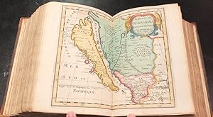
L'Amérique en plusieurs cartes, & en divers traittés de géographie, et d'histoire. Lŕ oů sont descripts succinctement, & avec une belle Methode, & facile, ses empires, ses peuples, ses colonies, leurs m?urs, langues, religions, richesses etc. Et ce qu'il y a de plus beau, & de plus rare dans toutes ses Parties, & dans ses Isles. Dédiée A Monseigneur Foucquet.
Date d'édition : 1657
Vendeur : Librairie Camille Sourget, Paris, France
Membre d'association : ILAB
Evaluation du vendeur :
Couverture rigide. Etat : Trčs bon. Paris, chez l'autheur, 1657.In-4 de (2) ff., (40) ff. et 15 cartes sur double-page. Veau brun granité, filet ŕ froid encadrant les plats, dos ŕ nerfs orné de fleurons dorés, coupes décorées, tranches mouchetées. Reliure de l'époque. 240 x 176 mm. --- Edition originale précieuse et trčs recherchée du fameux Atlas français de Nicolas Sanson (1600-1667) consacré ŕ l'Amérique, imprimé pour la premičre fois en 1657 et analysé dans « En Français dans le texte » (n°98). Sabin, XVII, 76708. Il est dédicacé ŕ « Monsieur Foucquet, conseiller du Roy » Louis XIV. Les délimitations des 15 cartes ont été coloriées ŕ l'époque. « L'Atlas d'Amérique est le dernier des quatre traités in-quarto que Sanson édita seul. Il parut un an aprčs celui d'Afrique et est, comme ce dernier, dédié ŕ Fouquet car, dit Sanson, « l'Afrique s'est si bien trouvée de la protection qu'elle a receu de vous ». Les cartes sont au nombre de quinze, soit sept pour l'Amérique du Nord, et huit pour l'Amérique du Sud. Seules les deux cartes générales du Nord et du Sud sont gravées par Abraham Peyrounin. Les autres cartes sont d'une autre main, anonyme. Comme les atlas d'Asie, d'Afrique et d'Europe, l'ouvrage fut réédité en 1662 (éd. B). Il subit ensuite deux altérations. Il existe en effet une troisičme édition (Ed. C), dans laquelle les cartes, dont la date a été grattée, portent l'adresse de Pierre Mariette ; le titre indique la męme adresse, mais « chez l'auteur ». Dans la quatričme édition (éd. D), le texte a été recomposé et augmenté ». « Ouvrage important pour la cartographie ancienne de l'Amérique : Canada, Floride, Mexique, Californie, Guatemala, Guyane, Amazone, Brésil, Chili, Paraguay, etc. » (Chadenat, n°6422). Les 15 cartes du continent américain figurent : -L'Americque septentrionale, -Le Canada, ou Nouvelle-France, -La Floride, -Audience de Mexico, -Audience de Guadalajara, Nouveau Mexique, Californie, -Audience de G /// Paris, chez l'autheur, 1657.4to [240 x 176 mm] of (2) ll., (40) ll. and 15 maps on double page. Granite-like brown calf, blind-stamped fillet on the covers, spine ribbed and decorated with gilt fleurons, mottled edges. Contemporary binding. --- Precious and highly sought-after first edition of the famous French atlas by Nicolas Sanson (1600-1667) dedicated to America, printed for the first time in 1657 and analyzed in "En Français dans le texte" (n°98). Sabin, XVII, 76708. It is dedicated to "Monsieur Foucquet, conseiller du Roy" Louis XIV. The delimitations of the 15 maps have been colored at the time. "The America Atlas is the last of the four 4to treatises that Sanson edited on his own. It was published a year after the Africa one and is, as this latter, dedicated to Fouquet because, Sanson says, 'Africa has found itself so well after the protection it received from you'. There are fifteen maps: seven for North America, and eight for South America. Only the two general maps of North and South are engraved by Abraham Peyrounin. The other maps are from another anonymous hand. As the atlases of Asia, Africa and Europe, the work was reprinted in 1662 (ed. B). Then it was altered twice. There is indeed a third edition (Ed. C), in which the maps, which date has been engraved, bear Pierre Mariette's address; the title indicates the same address, but 'at the author'. In the fourth edition (ed. D), the text has been recomposed and enlarged". "Important work for the ancient cartography of America: Canada, Florida, Mexico, California, Guatemala, Guyana, Amazonia, Brazil, Chile, Paraguay, etc." (Chadenat, n°6422). The 15 maps of the American continent contain: -L'Americque septentrionale, -Le Canada, ou Nouvelle-France, -La Floride, -Audience de Mexico, -Audience de Guadalajara, Nouveau Mexique, Californie, -Audience de Guatimala, -Les Isles Antilles, &c entre lesquelles sont les Lucayes et les Caribes, -Amerique meridionale, -Terre Ferme, Nouveau roy[au]me de Gre.
-
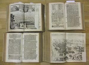
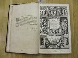
Flandria illustrata sive descriptio comitatus istius per totum terrarum orbem celeberrimi.
Edité par Köln, Egmondt, 1641 - 1644., 1641
Vendeur : Matthaeus Truppe Antiquariat, Graz, Autriche
Membre d'association : ILAB VDAO
Evaluation du vendeur :
Livre Edition originale
2 Bde. 12 Bll., 20 S., 1 Bl., S. 97 - 284, 2 Bll., S. 285 - 403, 2 Bll.; 8 Bll., S. 405 - 572, 1 Bl., S. 573 - 654, 1 Bl., 68, 38 (recte 40) S., 2 Bll. mit 2 Kupfertiteln und zahlreichen (darunter 38 doppelblattgroßen) Kupferstichen (in der Kollation). Erste Ausgabe dieser mit zahlreichen Ansichten, Porträts und Karten (teils doppelblattgroß, teils ganzseitig, teils gefaltet und zum Teil im Text) reich illustrierten Landeskunde von Flandern. - VD 17, 23:267123C. Graesse VI, 262. Honderd schatten uit de Koninklijke Bibliotheek van Belgie. Nr. 61. - Antonius Sanderus [Anton Sander] (1586 -1664) studied theology for some years under Malderus at Louvain, and Estius at Douai, and was ordained priest at Ghent. For some years he was engaged in parochial duties, and combated the Anabaptist movement in Flanders with great zeal and success. In 1625 he became secretary and almoner of Cardinal Alphonsus de la Cueva, later becoming canon, and in 1654 penitentiary at Ypres. After three years, however, he resigned this office to devote himself entirely to scientific, and especially to historical studies. He soon found himself compelled to claim the hospitality of the Benedictine Abbey of Afflighem, since he had reduced himself to absolute poverty by the publication of numerous works. He combined high intellectual gifts with great zeal, and left behind forty-two printed, and almost as many unprinted, works. The most important are the following: "De scriptoribus Flandriae libri III" (Antwerp, 1624); "De Gandavensibus eruditionis fama claris" (Antwerp 1624), "De Brugensibus eruditionis fama claris libri II" (Antwerp, 1624); "Hagiologium Flandriae sive de sanctis eius provinciae liber unus" (Antwerp, 1625; 2nd ed., Lille, 1639). A general edition of these four works appeared under the title: "Flandria illustrata" (2 vols., Cologne, 1641-44; The Hague, 1726). - Antonius "Sanderus signed a contract for the publication of this large work with Hondius in Amsterdam in the summer of 1634. In 1641, however, Hondius sold the rights of the book to Johan & Cornelis Blaeu. Blaeu intended to publish also a third volume, with the topographical description of the French part of Flanders, but this was never printed. Sanderus explains in the preface the etymologies of some old terms, which he had used in the text. This is followed by a general description of the geology and history of Flanders, with interesting details on the laws, language, politics, etc. There is a second edition published in 1732 and a third in 1735 (both printed in The Hague by Chr. van Lom), which contain, however, less plates". (Forum Rare Books). - "Chanoine d Ypres, connu pour la Bibliotheca Belgica manuscripta, le théologien Antoine Sanderus (1586 - 1664) publia en 1641 et 1644 chez Jean et Corneille Blaeu, les deux premiers volumes de sa Flandria illustrata, une description du comté de Flandres. Une troisičme partie, consacrée au Tournaisis et ŕ la Flandre gallicante, devait compléter l ensemble, mais cette édition, suite ŕ de nombreuses difficultés, ne vit jamais le jour. La plupart des planches préparatoires - des dessins ŕ la plume et ŕ l aquarelle évoquant des villes, des monuments, des abbayes, des châteaux, mais aussi des cartes et des plans - sont toutefois conservées dans le manuscrit 16823 de Bruxelles. On les attribue ŕ Vaast Du Plouich et aux autres assistants de Sanderus". (www.kbr.be). - Der Kupfertitel von Bd. 1 beschnitten und altaufgezogen. Beide Titel verso mit kleinem Doublettenstempel. Die Tafel "Gent" mit Randausriss (ohne Bildverlust, S. 582 mit Randeinriss bis ins Bild (ohne Verlust), S. 583 mit Eckabriss (minimaler Bildverlust). Buchblock von Bd. 2 minimalst angebrochen. Etw. gebräunt, teils stärker fleckig. *** *** Copyright: Matthaeus TRUPPE Buchhandlung & Antiquariat - Stubenberggasse 7 - A-8010 Graz - ++43 (0)316 - 829552 *** *** Sprache: Deutsch Gewicht in Gramm: 0 Fol. Marmoriertes Ldr. der Zeit mit Rückenschild und Rückenvergoldung (etw. berieben, oberes Kapital von Bd. 1 mit Einriss, Gelenke leicht angeplatzt).
-
Histoire du Canada et voyages que les frčres Mineurs Recollects y ont faicts pour la conversion des infidelles.
Edité par Paris, Claude Sonnius, 1636., 1636
In-8 (marg. 16,6 x 10,5 cms) de 1-312 pp. , (2)ff. (musique), (313)-1005 pp., (45)pp. de table. Ex-libris griffoné au titre. Anciennes restaurations marginales de papier ŕ 16 feuillets (dont des cachets ex-libris découpés) [ titre et aux ff. Giii, Miii (perte de 5 lettres), Nv, Tvi, Bbi (perte de 10 lettres, mouillure angulaire), Cci, Iiiii, Ppv, Qqii (mouillure angulaire), Xxvii, Eeei, Gggi (perte de 25 lettres, mouillure angulaire), Llliii, Qqqvii (perte de 10 lettres), Rrrv (perte de 18 lettres)]. Toutes les lettres manquantes ont été réécrites ŕ l'encre. Notre ouvrage est lacunaire de 20 feuillets ( f.Dii, de 2 cahiers V et X (soit 16 ff.), des 2 ff. de musique et le dernier feuillet de table. Ceux-ci ont été tous remplacés par de beaux fac-similés sur papier ancien.). Vélin souple de l'époque. Titre ŕ l'encre au dos. (réemboité dans sa reliure, gardes renouvelées). Edition originale d'une extrčme rareté. Des frčres récollets accompagnčrent Champlain en Nouvelle-France en 1615 ; ils s'établirent ŕ Québec dans une plus large mesure que les jésuites, mais en furent chassés en 1629 aprčs la prise de Québec par les Britanniques. Le pčre Sagard a vécu parmi les Hurons dans l'actuel sud de l'Ontario de 1623 ŕ 1624 et fournit ici de riches détails sur la culture et la langue. Cet ouvrage est considéré comme une extension de son premier Grand Voyage, qui détaillait « les voyages et les travaux missionnaires des Récollets parmi les Indiens du Canada ». Les voyages et les travaux missionnaires des Récollets parmi les Indiens du Canada, pendant neuf ans avant l'arrivée du Pčre Sagard, forment le sujet du Livre I. Le récit de son Grand Voyage au Pays des Hurons, paru trois ans auparavant. , est étendu par des détails supplémentaires, des chapitres xxii. Le Pčre Sagard publia cet ouvrage aprčs que Richelieu eut refusé de réintégrer les Récollets en France, donnant la préférence aux Jésuites. Sabin 74885 ("extręmement rare"). Oeuvre maîtresse de Gabriel Sagard, l Histoire du Canada, est un texte essentiel pour connaître les débuts de la colonisation française en Amérique du Nord.
-
L'Amerique en plusiers cartes nouvelles, et exactes, &e en divers traitez de Geographie, et d'Histoire. Lŕ oů sont descrits succinctement, & auec une bellee Methode, & facile. Ses Empires, ses Monarchies, ses estats, &les Moeurs, les langues, les Religions, le Negoce et la Richesse de ses Peuples, &c. et ce qu'il y a de plus beau & de plus rare dans routes ses Parties, & dans ses Isles.
Edité par Chez L'Autheur, 1667
Vendeur : Arader Galleries - AraderNYC, New York, NY, Etats-Unis
Evaluation du vendeur :
Livre
Hardcover. Etat : Very Good. Paris: Chez L'Autheur, [1667]. Quarto (9 5/8" x 7", 245mm x 178mm). With 16 double-page engraved maps. Bound in contemporary calf with gilt decoration and five raised bands on the spine. All maps mounted on guards with original hand-colour in outline, and with engraved colophon "Chez Pierre Mariette Rue St. Jacques a L'Esperence". Extremities worn, front cover starting at head and foot of spine. Rear hinge worn. Foxing and staining throughout. THE FIRST FRENCH ATLAS OF AMERICA. Nicholas Sanson D'Abbeville (1600-1667) was a French cartographer of Scottish descent, born in Abbeville in northern France. He served two kings, Louis XIII and Louid XIV, and was considered the premiere French cartographer of his time. Sanson published his first folio atlas in 1654 with 100 maps, engraved and printed by Pierre Mariette. Sanson's series of quarto atlases were originally published separately as "L'Europe" in 1648 by Sanson's son, also Nicholas, who was tragically killed in the "Barricades" insurrection the same year, "L'Asie" in 1652, "L'Afrique" in 1656, and "L'Amerique" in 1657. This atlas contains maps of Amerique Septentrionale, Isle d'Islande (1667), Le Canada, ou Nouvelle France, la Floride, Mexico, Guadalajara, Guatimala, Les Ilses Antilles, Amerique Meridionale, Terre Ferme. de Grenade, Guiane, Le Perou, Le Chilli, Le Bresil, Le Paraguay, and Detroit de Magellan. Sanson was known for supplying the most accurate geographic information and finest engraving, inititing the preeminent "French school of cartography". His "Cartes Generales de Toutes les Parties du Monde"was the most significant example of French cartography of the seventeenth century. Sabin 76708.
-
Description de l'Univers, contenant les differents systemes du monde, les cartes generales & particulieres de la Geographie Ancienne & Moderne: les Plans & les Profils des principales Villes & des autres lieux plus considerables de la Terre; avec les Portraits des Souverains qui y commandent, leurs Blasons, Titres & Livrées: et les Moeurs, Religions, Gouvernemens & divers habillemens de chaque Nation.
Edité par ParisChez Denys Thierry ., 1683
Vendeur : Robert Frew Ltd. ABA ILAB, London, Royaume-Uni
Membre d'association : ABA ILAB PBFA
Evaluation du vendeur :
Livre Edition originale Signé
FIRST EDITION. 5 vols. 8vo. (21x12 cm). Full 18th-century mottled calf, spine with raised bands and gilt in compartments, complementary red and green morocco labels, marbled endpapers. 5 engraved additional titles, 2 engraved portraits and 681 engraved plates (668 numbered plates, occasionally mis-numbered, and 12 "additional plates" bound at the end of volumes 2 & 3). Provenance: Gravier (signed in all volumes, dated 1684 in volume 5); ex libris Bibliotheque de Monsieur le Comte Godefroy de Montgrand, with his bookplate to paste-down of each volume. Inner hinges of vols. 4 and 5 strengthened with cloth tape, joints and extremities rubbed with some small partial losses, spine of volume 5 perished, contents toned but generally clean from further blemishes. First edition of this famed geographical guide known for its wealth of accurately delineated maps and views, most after the author, a skilled draughtsman with a background in mathematics and military engineering. In 1668, after serving Alfonso VI in Portugal, Mallet became mathematics master at the French court. His earlier Travaux de Mars (two editions, 1671 and 1684) was a treatise on fortification. Vol. I of the Description outlines the planetary system, vol. II is on Asia, III Africa, IV and first part of V Europe. The last volume is more of a catch-all, also having the 'terres Australes' and 'L'Amérique' as its subject. Volume 5 has dozens of views and maps of the Americas including Canada, Virginia, Florida, Mexico, California, and city views of Quebec and Havana among others. (Brunet, III, 1343), (Sabin, 44130).
-
Beschreibung des gantzen Welt-Kreysses, in sich begreiffend verschiedene Vorstellungen der Welt, allgemeine und besondere Land-Charten der alten und neuen Erd-Beschreibung; die Grund-und Abrisse der vornehmsten Städte.sambt den Bildnüssen der Könige und Potentaten.ingleichen Sitten, Religion, Regierungs-Formen und unterschiedliche Kleidungs-Arten jeder Nation. 5 Teile in 2 Bdn.
Edité par Zunner, Frankfurt, 1684
Vendeur : Antiquariat Stefan Krüger, Köln, NRW, Allemagne
Evaluation du vendeur :

Hardcover. Kl. 4°. 1684-1685. Pgmt. d. Zt. Bezug etwas gewellt. Mit 2 gest. Portraits und 607 gest. Tafeln, davon 232 Karten. VD17 39:129238(-42/48/ 50/55) Bircher 7313-7317. Gutes, sauberes Exemplar der ersten deutschen Ausgabe Übersetzt hat das Werk wahrscheinlich Phillip von Zesen. Die Anzahl der Tafeln schwankt von Exemplar zu Exemplar, unseres enthält 18 Tafeln mehr als bei VD17 angegeben. Atlas, Atlanten Geographie, Asien , Afrika. Buch.
-
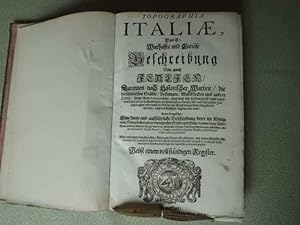
Topographia Italiae, Das ist: Warhaffte und Curiöse Beschreibung Von gantz Italien, Darinnen nach Historischer Warheit, die berühmtesten Städte, Vestungen, Marckflecken und andere Oerter, sampt ihren Antiquitäten; auch was sich sonsten merck- und denckwürdiges, sowol in Geistlichem als Politischen Stande, biß auff diese unsere Zeit zugetragen, oder durch die Natur und Kunst denenselben mitgetheilet worden: auff das fleissigste angemercket wird. Deme beygefügt, Eine kurtze und außführliche Beschreibung derer im Königreich Morea befindenden vornehmsten Städte und Plätze, darinn derer Alterthum, erlittene schwere Kriege, und was an ein und andern Orten merckwürdiges zubesehen, imgleichen was die Durchl. Republic Venedig, durch dero siegreiche Waffen zeithero darinn erobert und eingenommen. Alles auß denen bewährtesten, Alten und Neuen Scribenten, mit netten Kupffer-Abbildungen aller hauptsächlichsten Städte, Fürstl. und anderer Palläste, wie auch accuraten und künstlichen Land-Karten außg
Edité par Franckfurt (Frankfurt), Matthaei Merians Seel. Erben 1688., 1688
Vendeur : Aegis Buch- und Kunstantiquariat, Laichingen, Allemagne
Membre d'association : BOEV GIAQ
Evaluation du vendeur :
4° (4), 160, (11) S. mit 50 Kupfertaf. (66 Darstellungen) + Anhang Königreich Morea 29 (3) S. mit 3 Kupfertaf. (4 Darstellungen). Original-Lederband d. Zt. mit goldgepr. Rücken. (Einband berieben und bestossen, Kupfertitelblatt fehlt, Drucktitelblatt unten angerändert, Tafel Tivoli mit kleinem, fachmännisch hinterlegten Ausriß, Tafel Rom mit minimalem Einriß, insgesamt sehr schönes, frisches Exemplar). Wüthrich 81, 82. 1. Ausgabe mit tlw. falschen Paginationen 54/45; 102/106; 107/147; 153/315).
-
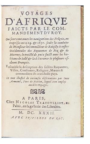
Voyages d'Afrique faicts par le commandement du Roy.
Date d'édition : 1632
Vendeur : Librairie Amélie Sourget, Paris, France
Membre d'association : ILAB
Evaluation du vendeur :
Edition originale
Couverture rigide. Etat : Trčs bon. Edition originale. ARMAND (Jean dit Mustapha). VOYAGES D AFRIQUE faicts par le commandement du Roy. Ou sont contenues les navigations des Fracois entreprises en 1629 & en 1630 soubs la conduite de Monsieur le Commadeur de Razilly es costes Occidentales des Royaumes de Fez & de Marroc Ensemble la description des susdits Royaumes, Villes, Coustumes, Religion, M urs & commoditez de ceux dudit pays. Le tout illustré de curieuses observations par Jean Armand, Turc de Nation. Paris, Nicolas Traboulliet, 1632. Petit in-8 de (4)ff. et 320 pp. Maroquin janséniste vert foncé, titre doré au dos ŕ nerfs, double filet or sur les coupes, dentelle intérieure, tranches dorées sur marbrure. Chambolle-Duru. 161 x 101 mm. « Edition originale extręmement rare » (Chadenat) DE L UN DES PLUS ANCIENS LIVRES EN FRANÇAIS RELATIFS AU MAROC. Chadenat, 5008 ; Brunet, I, 483 ; Gay, n°1215 bis ; Playfair, 181 ; Tailliart, 1430. Exemplaire avec le titre renouvelé ŕ la date de 1632 (quelques exemplaires portent la date 1631). This work shows the great interest which Richelieu attached to the maritime preponderance of France, and to commercial intercourse with Morocco (Playfair, Bibliography of Morocco, 181). Jean Armand, dit Mustapha, originaire de Turquie et converti ŕ la religion chrétienne, servit d'interprčte lors d'une expédition ordonnée par le cardinal de Richelieu sur le littoral atlantique des côtes de Barbarie. Cette mission fut menée en 1629-1630 par le chevalier Isaac de Razilly qui devait rétablir le commerce avec le royaume de Fez et le Maroc, et négocier le rachat de captifs français. La relation du voyage fut rédigée par Jean Armand d'aprčs des pičces officielles, les rapports de Razilly et des lettres de Richelieu. Ce trčs intéressant ouvrage contient des détails curieux et d'un grand intéręt sur les m urs et la religion des habitants de cette contrée et des observations sur la géographie ; il témoigne aussi du grand intéręt que portait Richelieu au commerce avec l Afrique du Nord. L ouvrage est dédicacé ŕ Richelieu. Les bibliographes soulignent l extręme rareté de cet ouvrage. « Edition extręmement rare d un de plus anciens livres relatifs au Maroc » (Chadenat) Brunet ne cite qu un exemplaire, l exemplaire Langlčs. BEL EXEMPLAIRE RELIE PAR CHAMBOLLE-DURU. Provenance : Bibliothčque Duplessis-Villoutreys, avec ex-libris.
-
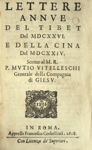
Lettere annue del Tibet del 1626 e della Cina del 1624. Scritte al M.R. P. Mutio Vitelleschi Genarale della Compagnia di Giesu.
Date d'édition : 1628
Vendeur : Librairie Camille Sourget, Paris, France
Membre d'association : ILAB
Evaluation du vendeur :
Couverture rigide. Etat : Trčs bon. Roma, Francesco Corbelletti, 1628.In-8 de 130 pp. Qq. rousseurs, reliure du sičcle dernier en plein vélin ivoire, tranches rouges. 148 x 96 mm. --- Édition originale de la plus insigne rareté de ces deux relations des années 1624 et 1626 concernant la Chine et le Tibet. Collation conforme ŕ Cordier, Bibliotheca Sinica, 815. La lettre du Tibet, pages 3-58 est du Pčre Andrada ; elle est datée de Caparangue (Tsaparang), le 15 aoűt 1626. La lettre de la Chine, pages 59-130, est du Pčre Venceslas Pantaleone ; elle est datée de Macao, le 27 octobre 1625. "Contains letters from Antonio de Andrade, Aug. 15, 1626, and Kirwitzer in Macao, Oct. 27, 1625". (Asia in the making of Europe, p. 1994). « Antoine de Andrade, portugais, né vers l'an 1580, entra fort jeune dans la Compagnie, et se distingue par un zčle infatigable, dans les missions des Indes et de la Tartarie. La Géographie lui doit une découverte importante : il pénétra dans le Thibet en 1624. De retour ŕ Goa, ses supérieurs l'employčrent dans plusieurs affaires importantes. Il mourut empoisonné le 16 mars 1634 ». (Bibliothčque des écrivains de la Compagnie de Jésus, 1853, p. 16). Cette « lettre du Tibet » relate le second voyage du Pčre Andrade au Tibet, en 1625-1626. Il commença son second voyage d'Agra en juin 1625, et atteignit Tsaparang le 28 aoűt de la męme année. Cette relation sera traduite en français en 1629 sous le titre : Histoire de ce qui s'est passé au royaume du Tibet. Tirée des lettres escrites en l'année 1626. Adressée au R.P. Mutio Vitelleschi, General de la Compagnie de Jésus. Traduite d'italien en français par un Pčre de la mesme Compagnie, Paris, chez Sébastien Cramoisy, 1629, puis en flamand par le P. Jacques Dyck. Les relations concernant le Tibet sont introuvables ; celles concernant la Chine dans les premičres années du XVIIe sičcle sont trčs recherchées. /// Roma, Francesco Corbelletti, 1628. 8vo [148 x 96 mm] of 130 pp. A few foxing, binding from the last century in full ivory vellum, red edges. --- First edition of the great rarity of these two relations of the years 1624 and 1626 regarding China and Tibet. Collation identical to Cordier, Bibliotheca Sinica, 815. The letter from Tibet, pages 3 to 58 is by Father Andrada; it is dated August 15th 1626, in Caparangue (Tsaparang). The letter from China, pages 59 to 130, is by Father Venceslas Pantaleone; it is dated October 27th 1625 in Macao. "Contains letters from Antonio de Andrade, Aug. 15, 1626, and Kirwitzer in Macao, Oct. 27, 1625". (Asia in the making of Europe, p. 1994). "Antoine de Andrade, was a Portuguese born towards 1580. He joined the Compagnia very young, and is distinguishable by his tireless zeal, in the Indian and Tartar missions. Geography owes him an important discovery: he entered Tibet in 1624. Back in Goa, his superiors employed him in various important matters. He died poisoned on Marche 16th 1634." (Bibliothčque des écrivains de la Compagnie de Jésus, 1853, p. 16). This "letter from Tibet" recounts Father Andrade's second travel in Tibet, in 1625-1626. He started his trip to Agra in June 1625, and reached Tsaparang on August 28th of the same year. This relation will be translated into French in 1629 under the title: Histoire de ce qui s'est passé au royaume du Tibet. Tirée des lettres escrites en l'année 1626. Adressée au R.P. Mutio Vitelleschi, General de la Compagnie de Jésus. Traduite d'italien en français par un Pčre de la mesme Compagnie, Paris, Sébastien Cramoisy, 1629, then in Flemish by F. Jacques Dyck. Relations regarding Tibet are unobtainable; the ones regarding China during the first years of the 17th century are highly sought-after.
-
Description de tout L'Univers en plusieurs cartes, en divers traitez de Geographie et d'Histoire . par Mrs Sanson Pere Fils.
Edité par Sanson / Halma, 1700
Vendeur : Barry Lawrence Ruderman, La Jolla, CA, Etats-Unis
Membre d'association : ABAA ILAB
Evaluation du vendeur :
Livre
Hardcover. Etat : VG+. Sanson / Halma / 1700 / Description de tout L'Univers en plusieurs cartes, en divers traitez de Geographie et d'Histoire . par Mrs Sanson Pere Fils. (Safe 1, 68884) Small quarto. Contemporary calf (rebacked, old spine laid down). 6 parts in one volume, including Bion's L'Usage des globes and Luyts' Tables. Double-page letterpress title printed in red and black with engraved vignette, hand-colored initials and headpieces, double-page engraved frontispiece (dated 1760) and 72 (of 74) maps (lacking Amerique Septentrionale and Isles Bermudes ), the Bion with one double-page celestial map and 14 diagrams (10 folding), all in beautiful original hand-color. (Some light browning.) A beautiful miniature Halma edition of a Sanson gentleman's pocket atlas in exquisite full contemporary Dutch color. The volume includes Sanson's pocket atlas, with Bion's useful work on globes. Although this atlas is always listed under Nicolas Sanson, it is essentially Francois Halma's plagiarized pocket version of the Sanson atlas, with the map divided into continent groups. Halma (1653-1722) also reprinted Mercator's Ptolemy and Bonfrere's Geography for the growing French market. The engraved allegorical title-page has caused some confusion among catalogers in the past, as it includes the date "1760". In all likelihood, this is an inversion of 1706 or some similar error, as Halma was dead by 1722. Neither the coloring nor anything else about the book suggests that it was published after 1720. Provenance Baltazar Ciecierski (born 1680), court official of Drohiczyn, in Poland (inscribed on first dedication leaf Ex biblioteca M. Balthasaris Ciecierskei [.] ); Jean R. Perrette, famed atlas and travel book collector. His sale, Christie's New York, 2016. Book.
-
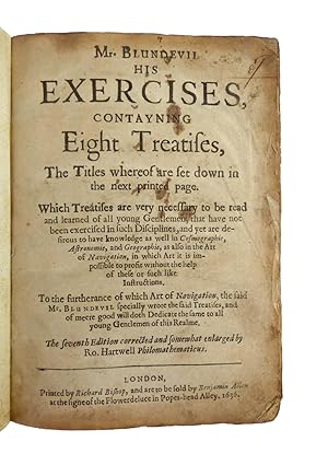
Mr. Blundevil his exercises contayning eight treatises, the titles wherof are set down in the next printed page. Which treatises are very necessary to be read and learned of all young gentlemen, that have not been exercised in such disciplines, and yet are desirous to have knowledge as well in cosmographie, astronomie, and geographie, as also in the arte of navigation . To the furtherance of which art of navigation, the said Mr. Blundevil specially wrote the said treatises, and of meere good will doth dedicate the same to all young gentlemen of this realme.
Date d'édition : 1636
Vendeur : Bruce Marshall Rare Books, Cheltenham, Royaume-Uni
Membre d'association : ABA ILAB
Evaluation du vendeur :
Livre
Hardcover. Etat : Very Good. A briefe description of the tables of three speciall right lines belonging to a circle, called sines, tangents, and secants , A plaine description of Mercator his two globes , A plaine and full description of Petrus Plancius his universall map , A very briefe and most plaine description of Mr Blagrave his astrolabe , and A briefe description of universall maps and cards .Each have separate dated title page; A plaine treatise of the first principles of cosmography and A nevv and necessary treatise of navigation each have separate title page; foliation and register are continuous. - A briefe description of universal mappes and cards was first published separately in 1589. With moveable volvelles on leaves 315, 720, 744. London, 1636: Printed by Richard Bishop, and are to be sold by Benjamin Allen at the signe of the Flowerdeluce in Popes-head Alley. The seventh edition, corrected and somewhat enlarged by Ro. Hartwell philomathematicus, Contemporary calf, rebacked. A very important book in the history of navigation The Exercises described the world map of Petrus Plancius, Molyneaux s large terrestrial globe, being the first globe to be made in England, the works of John Balgrave, Gemma Frisius, and the cross-staff of Thomas Hood. He first published his Exercises in six parts, containing a brief account of arithmetic, cosmography, the use of the globes, a universal map, the astrolabe, and navigation. The arithmetic is taken from Recorde, but to it are added trigonometrical tables (copied from Clavius) of the natural sines, tangents, and secants of all angles in the first quadrant; the difference between consecutive angles being one minute. These are worked out to seven places of decimals. This is the earliest English work in which plane trigonometry is introduced. Later editions including this 1636 edition (from 1613 onwards) showed the circumnavigations of Francis Drake and Thomas Cavendish. His circle of friends included Sir Nicholas Bacon and mathematicians and astronomers including John Dee, Edward Wright, Henry Briggs and William Gilbert.
-
Geographia universalis Pars prior - [Pars posterior]. Das ist Der allgemeinen Erd-Beschreibung
Edité par Nuremberg: Christoff Gerhard for Johann Hoffman, 1679., 1679
Vendeur : Arader Galleries - AraderNYC, New York, NY, Etats-Unis
Evaluation du vendeur :
Edition originale
2 volumes. 12mo., (5 2/8 x 2 6/8 inches). 2 engraved title-pages. 83 engraved maps, most double-page or folding, and 16 full-page engraved woodcut coats of arms (map of Bavaria with small marginal tear affecting the image). Contemporary vellum over paste-board, title in manuscript on the spines; preserved in a blue cloth clamshell box. Provenance: with the engraved armorial bookplates of Christoph Wenzel Graf von Nostitz (1643-1712), on the front paste-down of each volume, and his signature on each title-page. First German edition, first published in French as "Le Monde ou la Geographie universelle", 1663. The atlas describes America, Africa, Asia, and Europe in detail illustrated with numerous maps of each. Maps related to America include the Western Hemisphere, and the world map, Terra Arctica, America (showing California as an island), Canada, Virginia, Florida, Nova Mexico (showing Californa as an island), Mexico sive N. Hispania, Insula Antiles, Guaiana, Castilo Doro, Peru, Chili, Terra Magellanica, Tucuman, LaPlata, Brasilia, and Insulae Capo Viridis. Maps relating to the Pacific and Indian Ocean regions include Terra Antarctica, Asia showing the East Indies, Insulae Sindae, Insulae Moluccae, as well as maps of Ceylon, the Maldives and Japan. "Like his uncle Nicolas Sanson, Pierre du Val was born in Abbeville. He produced a variety of cartographical works from 1654 onwards until his death in 1683, with later editions being published by his widow Marie Desmaretz" (Shirley). Sabin 21482 citing the French edition of 1688. Catalogued by Kate Hunter.
-
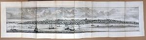
Reizen Van Cornelis de Bruyn, Door de vermaardste Deelen van Klein Asia, DeEylanden Scio, Rhodus, Cyprus, Metelino, Stanchio, &. Mitsgaders de voornamste Steden van Aegypten, Syrien, En Palestina. Verrijkt met meer als 200. kopere Koonstplaten,
Edité par Delft, Henrik van Krooneveld 1698., 1698
Vendeur : Antiquariat Burgverlag, Wien, Autriche
Membre d'association : ILAB VDA VDAO
Evaluation du vendeur :

2°. (40 x 26,5 cm.). Titelportr., Frontisp., Titel, 8 Bll., 398 S., 4 Bll. (Register). Mit Titelportr. (d. Autors nach Godfrey Kneller), Frontisp., 1 gefalt. gr. Karte, 104 Kupfertaf. (dav. 24 gefalt. bzw. doppelbl.-gr. u. 17 gr. mehrf. gefalt. Panoramen), 18 Textkupfer. (Numeriert A(2) & 1-210). Ldr. d. Zt. Rückenkanten restaur. In sehr gutem Zustand. Röhricht 1184; Tobler 114; Cohen-de Ricci 610; Graesse I, 552; Henze I, 378; Gay 2101 - Komplettes Exemplar der ersten Ausgabe in der großformatigen Ausgabe (40 x 26,5 cm.) auf starkem Büttenpapier. Viele Kupfer gest. v. Jan u. Casper Luyken nach Zeichnungen de Bruyns. Die großen Panoramen zeigen Smyrna, Constantinopel, Scio, Rhodos, Tyrus, Alexandria, Rama, Betlehem, Jerusalem, Aleppo, Palmyra, Sattalia, Haselaar. - Cornelis de Bruyn (1652-1727 Utrecht), bereiste bereits ab 1681 merhmals die Levante, Ägypten und den Mittleren Osten. Seine Bücher wurden im 18. Jahrhundert viel gelesen. Als Maler konnte er exakte Zeichnungen anfertigen und mit seinen Beschreibungen wertvolle Informationen vermitteln. 1 frontispiece & Over 200 ills. on 120 copper-engraved plates. (58 single-page plates, 26 double-page plates, 18 large folded panoramas, 17 text-ills. & 1 map). - with engraved half-title, engraved portrait of the author (after Godfrey Kneller), and 210 as well as several lettered or unnumbered engravings (many by Jan and Caspar Luyken after the author`s drawings) printed on 57 plates, 24 double-page plates and 20 folding plates (also panoramic views), small folio (35 x 23 cm), - Large paper copy, A normal copy is 34 cm x 22cm, this one 40.5 cm x 26 cm. . [11] 398 [8] Large paper copies were sold at a higher price for top end Complete copy with all 122 plates with the often missing map! 18 (very) large folding panoramic views, 28 folding plates and 56 full-plates, numerous half-plates text-illustrations. Gewicht in Gramm: 5000.
-
Die gantze Erd-Kugel / Bestehend In den vier bekannten Theilen der Welt / Als Europa, Asia, Africa und America. Sampt schönen neuen und accuraten Land-Karten / Nebenst einer Geographischen und Historischen Beschreibung Aller Darinnen befindlichen Kayserthümer / Königreiche / Landschafften und Städte / Sitten der Völcker / dero Sprachen / Religionen / Handel- und Gewerbschafft / Reichthümer / auch was darinnen seltsames und merckwürdiges zu sehen und zu finden ist. In Frazösischer Sprache erstlich bescrheiben Von . Und denen Liebhabern zum Besten in die Hochteutsche Sprache getreulich übersetzet
Edité par Franckfurt am Mayn: Johann David Zunners 1679, 1679
Vendeur : Antikvariat Valentinska, Praha, Rébublique tchčque
Membre d'association : ILAB
Evaluation du vendeur :
Pergamenteinband der Zeit mit handgeschriebenem Titel auf dem Rücken, [4]+184 [Europa], 71 [Asia], 78 [Africa], 79 [America] Seiten, 4° (19 x 24 cm) mit 62 gefalteten Karten und gestochenem Schmutztitelblatt; Pergament vor allem an den Kanten berieben, eingerissen, wesentlich neuere Anpappblätter, Schmutztitel gebräunt, angeschmutzt, mit zahlr. Rissen, so wie viele andere Seiten von hinten unterklebt; Frontispiz mit handgemaltem Wappen und Besitzerkennzeichnung, durchgehend Textseiten und Karten gebräunt, lädiert, unterklebt, insgesamt noch guter Zustand. Book Language/s: German.
-
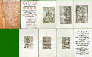
Trinum Marinum . Arca Temporum Mundi reserata .
Edité par Augsburg, 1693
Vendeur : Antikvariat Krenek, Prag, Rébublique tchčque
Membre d'association : ILAB
Evaluation du vendeur :
Philo Cosmographus (pseud.). "Trinum Marinum: Oder: Die an einander hangende Drey Meer. Pontus Euxinus, . cum Archipelago: . Das Schwartze / Wisse / und Egeische Meer: Mit ihren innliegenden Insulen . Städten / Vestungen / Gebürgen / Seen / Flüssen / Thieren / Vögeln / Fischen . in vilen Kupffern vorgestellt". Augsburg: Nepperschmid for J. Enderlin, 1693. Fol. (2), 61, (1) pp. Bound together with: Dtto. "Arca Temporum Mundi Reserata. Oder: . Die Tyrannisirungs- Zeit Der Ottomannischen Porten". Dtto. 64 pp. With 38 plates containing 39 engravings (a. o. 32 city-views, maps). Orig. paper binding with marbled paper on the front and rear desk. - Spine of the book expertly restored. Lower left part of the title-page of the first book torn off and expertly filled in with old paper. Otherwise in very good condition.
-
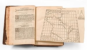
(Navigation, Mapmaking, and Mathematics) M. Blundevile His Exercises, Contayning eight Treatises, the Titles where-of are set downe in the next Printed Page: which Treatises are very necessary to be read and learned of all yong Gentlemen that have not beene exercised in such Disciplines, and yet are desirous to have knowledge as well in Cosmographie, Astronomie, and Geographie, as also in the Art of Navigation, in which Art it is impossible to profit without the helpe of these, or such like Instructions.
Edité par Blundeville, 1622
Vendeur : Barry Lawrence Ruderman, La Jolla, CA, Etats-Unis
Membre d'association : ABAA ILAB
Evaluation du vendeur :
Livre
Hardcover. Etat : VG. Blundeville / 1622 / (Navigation, Mapmaking, and Mathematics) M. Blundevile His Exercises, Contayning eight Treatises, the Titles where-of are set downe in the next Printed Page: which Treatises are very necessary to be read and learned of all yong Gentlemen that have not beene exercised in such Disciplines, and yet are desirous to have knowledge as well in Cosmographie, Astronomie, and Geographie, as also in the Art of Navigation, in which Art it is impossible to profit without the helpe of these, or such like Instructions. (Safe 2, 100838) Octavo. Contemporary English calf, covers ruled in blind, spine in five compartments separated by raised bands, lettered in gilt in the second "BLVNDEVIL", the others with elaborate floral designs in gilt (spine and corners worn with some loss, hinges reinforced.) A-[Eee8]. [16], 799, [1] pages. 5 folding woodcuts and tables, woodcut diagrams in text, 3 with volvelles (on pages 660, 720 and 744). (I2 with small loss from lower corner not affecting printing.) VG or better. In a Contemporary Binding. A nice example in a contemporary binding of the 1622 sixth edition of Thomas Blundeville's foundational work on practical mathematics, navigation, and mapmaking, often called "His Exercises". This lengthy work laid the groundwork for cartographic and maritime education during the Jacobean and Early Stuart era. It played a pivotal role in formalizing instructional materials as England rose to prominence as a global sea power. Blundeville's "Exercises" were initially published in six parts, encompassing a concise overview of arithmetic, cosmography, the usage of globes, a universal map, the astrolabe, and navigation. While the arithmetic section drew inspiration from the works of Record, it also incorporated trigonometric tables, borrowed from Clavius, featuring the natural sines, tangents, and secants of all angles within the first quadrant, with a minute difference between consecutive angles. Impressively, these tables were calculated to seven decimal places. This marked a significant milestone, as it represents the earliest introduction of plane trigonometry in the English language. D.W. Waters, The Art of Navigation in England in Elizabethan and Early Stuart Times, London, 1958, pages 213-215: Blundeville's Exercises have a triple interest. They consist of a series of treatises on mathematical, astronomical, and navigational knowledge necessary for a young man wishing to master fully the art of navigation as practised in the closing years of Elizabeth I's long reign. Besides some original contributions of his own to the art of navigation, Blundeville in his treatise was the first Englishman to describe the use of the tables of the three trigonometrical functions--sine, tangent, and secant. He drew freely upon the works of the various writers for definitions, illustrations, examples, and tables, and thus presented to the student an authoritative and up-to-date synthesis of the theories and practices of the art of navigation in the 1590s. The first edition of the "Exercises" was published in London by John Windet in 1594. Content on Exploration and the Americas The book contains lengthy passages about voyages and contemporary explorers, some of which include personal commentary by Blundeville (e.g., ".from this Bay Sir Francis himselfe (as I have heard ) was of very good wil to have sayled stil more Northward.") He also makes use of lengthy translations and transcriptions from the more important globes (i.e. Molyneux's) and world maps (i.e., Plancius's) of the latter decades of the 16th century. As noted by Sabin (6024), pages 515-520 include accounts of "Sir Francis Drake's First Voyage unto the West and East Indies; both outward and homeward" and "the Voyage of M. Candish [Thomas Cavendish], unto the We. Book.
-
Nova typis transacta navigatio. Novi orbis Indiae occidentalis [.]. Nunc primum e variis scriptoribus in unum collecta, & figuris ornata.
Edité par Ohne Ort (vermutl. Linz), ohne Drucker, 1621., 1621
Vendeur : Versandantiquariat Wolfgang Friebes, Graz, Autriche
Membre d'association : ILAB VDAO
Evaluation du vendeur :
Edition originale
Etat : 0. Erstausgabe (eine von zwei Varianten mit dem Erscheinungsjahr 1621; da die andere Variante ein zusätzliches, 1622 datiertes Widmungsblatt enthält, handelt es sich hier vermutlich um den ersten Druck der ersten Ausgabe). - Berühmte und kuriose Darstellung der Entdeckung Amerikas durch Kolumbus und der ersten Missionstätigkeit der Benediktiner unter Pater Buell, der ausgesandt wurde um die Indianer zu bekehren. - Gesucht auch wegen Wolfgang Kilians phantastischer Kupferserie (darunter St. Brendans Predigt auf dem Wal zwischen Afrika und den Kanaren [siehe Burden, Mapping of North America, pl. 1]; Kolumbus mit einer kreisförmigen Atlantikkarte, sowie Begegnungen mit Indianern; deren Sitten u. Bräuche usw.). - Blattränder tlw. etw. bestoßen bzw. m. kl. Läsuren u. Eckknicken. Einige Bll. (auch Tafeln) m. vereinzelt längeren Einrissen. Tafeln tlw. bis zur Einfassungslinie beschnitten. Durchg. etw. gebräunt u. stock- bzw. fingerfleckig, gegen Ende auch etw. wasserrandig. - VD17, 23:230863B; Sabin 63367; Brown II, 156f.; Brunet III, 618; Duviols, L Amérique espagnole vue et revée 100; Harrisse 384,18; Leclerc I, 1161; Maggs 53; Rare Americana (1928) 40; Alden/L. 621/100; JCB II, 156; Streit II, 1527; Palau 224.762; Arents Suppl. 201; nicht bei Church. la Gewicht in Gramm: 1000 Fol. Mit gest. illustr. Titel, einem emblemat. Textkupfer, 3 Textholzschnitten, 18 Kupfertafeln (von Wolfgang Kilian) u. einigen Holzschn.-Vignetten bzw. -Initialen. 6 Bll., 101 (1) S., 2 Bll. (das letzte weiß), Mod. HPgmt.
-
Paralelle des Anciens et des Modernes en ce qui regarde les arts et les sciences. Dialogues. Avec le Poëme du Sičcle de Louis le Grand, Et une Epistre en vers sur le Génie. Par M. Perrault de l'Académie Françoise (Tome premier) ? L'Éloquence (tome II) ? La Poésie (tome III) ? L'Astronomie, la Géographie, la Navigation, la Guerre, la Philosophie, la Musique et la Médecine (tome IV).
Date d'édition : 1692
Vendeur : Librairie Camille Sourget, Paris, France
Membre d'association : ILAB
Evaluation du vendeur :
Couverture rigide. Etat : Trčs bon. Paris, Veuve Coignard et Jean Baptiste Coignard fils, 1692?1693-1696. 4 volumes in-12 de : I/ (20) ff., 252 pp., 8 pp. ch. 27-34, 34 pp., (1) f.bl.; II/ (9) ff., 399 pp. et (1) p. de privilege; III/ (6) ff., 335 pp., (1) p. de privilčge, 1 cahier bruni ; IV/ (8) ff., 321 pp., (1) f. d'errata, 1 figure gravée sur cuivre entre les pp. 296 et 297 de « l'arbre de Porphyre ». Cachet en marge inf. des p. 13 du tome 1, p. 12 du tome 2, pp. 1 et 13 du tome 3, pp. 1 et 13 du tome 4.Plein veau moucheté de l'époque, dos ŕ cinq nerfs ornés de fleurons dorés, roulette dorée sur les coupes, tranches mouchetées rouges. Reliure de l'époque. 164 x 92 mm. --- Édition originale collective ? les tomes 3 et 4 sont ici en édition originale aux dates de 1692 et 1696 - de la fameuse « Querelle des Anciens et des Modernes », ?uvre majeure de Charles Perrault. Le 4čme volume est ici l'un des rares connus ŕ la date de 1696, la date commune étant de 1697. Scheler (V, p. 169) mentionne : « J'ai rencontré un exemplaire du ?Parallelle des anciens et des modernes' dont le tome 4 était daté M.DC.LXXXXVI (1696). Il comportait, relié ŕ la fin, un errata intitulé ?Fautes ŕ corriger', tiré sur un feuillet indépendant » ; cas du présent exemplaire. Cette édition originale présente l'intégralité des brűlots que Perrault lança dans une querelle qui devait enflammer tout le milieu littéraire de son temps et se prolonger pendant tout le XVIIIe sičcle, jusqu'ŕ Condorcet, jusqu'au Génie du Christianisme. « Perrault fonde l'expérience du progrčs culturel dans une théorie historique (?). C'est dans la ?Querelle' que se forme la nouvelle conscience historique qui sera celle des Lumičres : le trait fondamental de l'histoire devient un mouvement irréversible vers l'avant » (P. -E. Knabe, R. Mortier, F. Moureau, L'aube de la modernité 1680-1760, p. 6 sq.).Ce texte fondateur revęt une telle importance que nous allons en décrire la Genčse et l'ab /// Paris, Veuve Coignard et Jean Baptiste Coignard fils, 1692?1693-1696. 4 volumes 12mo [164 x 92 mm] of : I/ (20) ll., 252 pp., 8 pp. numbered 27-34, 34 pp., (1) bl. l.; II/ (9) ll., 399 pp. and (1) p. of privilege; III/ (6) ll., 335 pp., (1) p. of privilege, 1 browned quire; IV/ (8) ll., 321 pp., (1) l. of errata, 1 copper engraving between pp. 296 and 297 of « l'arbre de Porphyre ». Stamp in the lower margin of p. 13 of part 1, p. 12 of part 2, pp. 1 and 13 of part 3, pp. 1 and 13 of part 4. Bound in full contemporary mottled calf, spine with five ribs decorated with gilt fleurons, red mottled edges. Contemporary binding. --- First collected edition ? parts 3 and 4 are in first edition with the dates 1692 and 1696 ? of the famous "Quarrel of the Ancients and the Moderns", major work of Charles Perrault. The 4th volume is here one of the very few with the date 1696, the usual date being 1697. Scheler (V, p. 169) mentions: "I've seen a copy of ?Parallel between ancients and moderns' of which part 4 was dated M.DC.LXXXXVI (1696). It contained, bound at the end, an errata entitled ?Mistakes to correct', printed on a separate leaf"; case of the present copy. This first edition presents the integrality of the polemical writings that Perrault launched in a quarrel who would inflame all the literary environment of his time and extend during all the 18th century, up to Condorcet, op to the Genius of Christianity. This founding text is so important that we will describe its genesis and its outcome. The Classics or Ancients led by Boileau sustained a conception of literary creation as an imitation of the authors of antiquity. This thesis was based on the idea that Greek and Roman antiquity had reached once and for all the artistic perfection. The Moderns, represented here by Charles Perrault, who supported the merit of the authors of the century of Louis XIV, affirmed on the contrary that the authors of Antiquity were not impassable, and that the literary c.
-
Newe Welt Und Americanische Historien. Inhaltende Warhafftige und vollkommene Beschreibungen Aller West-Indianischen Landschafften/ Insulen/ Königreichen und Provintzien/ Seecusten/ fliessenden und stehenden Wassern/ Port und Anländungen/ Gebürgen/ Thälern/ Stätt . in diesem halben Theil deß Erdkreyses. Deßgleichen Gründlicher Bericht von der Inwohner Beschaffenheit/ Sitten/ Qualitäten/ Policey und Götzendienst/ . sampt Unterscheid der Nationen/ Sprachen und Gebränchen. Item, Historische und Außführliche Relation 38. Fürnembster Schiffarten unterschiedlicher Völcker in West-Indien .
Edité par Franckfurt, Merianschen Erben., 1655
Vendeur : EOS Buchantiquariat Benz, Zürich, Suisse
Membre d'association : ILAB VEBUKU
Evaluation du vendeur :
Livre
2°. (3) Bl., 661, (2) S. Mit gestochenem Titel, 5 doppelblattgrosse Kupferkarten (davon 3 gef.), 2 doppelblattgrosse Kupfertafeln und 174 Textkupfer (davon 5 Karten). Späterer Halblederband mit handschriftlicher Rückenbeschriftung. VD17 39:133320M. Unklar, ob die 8. Kupfertafel wirklich publiziert wurde. Bei allen Ex. im Handel im Maximum 7 Tafeln, wie bei vorliegendem Exemplar. Bibliogr: vgl. Sabin und Wüthrich! - Zum Teil stärkere Gebrauchsspuren. Titelblatt beschnitten, Landkarte von Brasilien mit Bildverlust an der unteren linken Ecke. Kleinere Einrisse, durchgehend gebräunt. Sprache: deutsch / german. + Wichtig: Für unsere Kunden in der EU erfolgt der Versand alle 14 Tage verzollt ab Deutschland / Postbank-Konto in Deutschland vorhanden +.
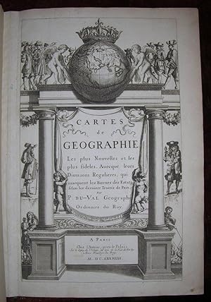

![Image du vendeur pour [MANUSCRIT] Cartes particuličres par gouvernements de la province de Dauphiné mis en vente par Pingel Rare Books](https://pictures.abebooks.com/inventory/md/md30884224826.jpg)
![Image du vendeur pour I. Geographiae libri octo, recognitiam diligenter. [II. Galliae Tabule Geographicae. Belgii Inferiores Geographicae Tabule]. mis en vente par JF LETENNEUR LIVRES RARES](https://pictures.abebooks.com/inventory/md/md22846645099.jpg)