Montant total (1 article articles) :
Destination de la commande :

geographie (Plus de 54 000 résultats)
Passer aux résultats principaux de la recherche
Type d'article
- Tous les types d'articles
- Livres (51 117)
- Magazines & Périodiques (128)
- Bandes dessinées
- Partitions de musique
- Art, Affiches et Gravures (870)
- Photographies (35)
- Cartes (2 302)
-
Manuscrits &
Papiers anciens (136)
Etat
Reliure
Particularités
- Edition originale (4 268)
- Signé (1 046)
- Jaquette (623)
- Avec images (39 003)
- Sans impression ŕ la demande (54 433)
Livraison gratuite
Pays
Evaluation du vendeur
-
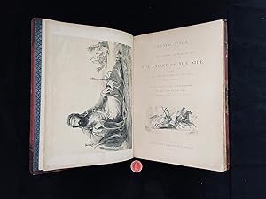
The Holy Land, Syria, Idumea, Arabia, Egypt & Nubia. With historical descriptions by George Croly and William Brockedon.
Edité par London, Moon, 1842 - 1849., 1842
Vendeur : Matthaeus Truppe Antiquariat, Graz, Autriche
Membre d'association : ILAB VDAO
Evaluation du vendeur :

Livre Edition originale
6 Bde. 3 Bll., 30 S., 21 Bll.; 23 Bll.; 2 S., 18 Bll.; 2 Bll., 8 S., 21 Bll.; 22 Bll.; 24 Bll. mit 120 Textabb. 3 Frontisp., 6 Titel, 1 Porträt, 118 Tafeln (alles in getönter bzw. farbig getönter Lithographie von Louis Hague), 2 Kupferkarten. Erste Ausgabe dieses epochalen Tafelwerks über den Nahen Osten mit allen 248 Ansichten des Heiligen Landes (in getönten Lithos) und Ägyptens (in farbig getönten Lithos). - Blackmer 1432. Lipperheide 1590 und 1591. Röhricht 1983. Abbey, Travel, 385 und 272. - "David Roberts was the first professional artist to visit the Near East without a patron or a connection to a military expedition or missionary group. He sailed to Alexandria in 1838 and for eleven months traveled up the Nile River, across deserts and mountains, through Egypt and the Holy Land, to arrive in Jerusalem on Easter 1839. He continued north to Lebanon and departed from Beirut in May. Roberts recorded his impressions of landscapes, temples, ruins, and people in three sketchbooks and more than 272 watercolors. These sketches and paintings provided the basis for the 247 lithographs published with text between 1842 and 1849 as the three-volume "Holy Land." The images were produced by Louis Haghe, the best and most prolific lithographer of the time. Originally from Tournai, Belgium, Haghe moved to England before 1825 and established himself as specialist of the hand-tinted lithograph. His sensitive handling of the lithographer`s tools imparts a range of tonality and color as well as a sense of the delicacy and spontaneous quality of Roberts`s original images. Roberts`s plates are among the most popular images of famous sites in the Near East. As John Ruskin wrote they make "true portraiture of scenes of historical and religious interest. They are faithful and laborious beyond any outlines from nature I have ever seen." (ww.metmuseum.org). - "In point of bulk and ambition Roberts`s Holy Land was one of the most important and elaborate ventures of nineteenth-century publishing, and it was the apotheosis of the tinted lithograph. There is pleasure to be had from many of the individual plates, where Haghe`s skilful and delicate lithography, and his faithful interpretation of Roberts`s draughtsmanship and dramatic sense, combine in what are undoubtedly remarkable examples of tinted lithographic work. Particularly in the Egypt and Nubia section, one feels that the colossal subjects and broad vistas were ideally suited to Roberts`s talent, trained as he was in theatrical scene-painting during his early days in Carlisle, Glasgow, Edinburgh, and London.Roberts was fully appreciative of Haghe`s work, writing that: `Haghe has not only surpassed himself, but all that has hitherto been done of a similar nature. He has rendered the views in a style clear, simple, and unlaboured, with a masterly vigour and boldness which none but a painter like him could have transferred to stone`" (Abbey 341). - Das Werk erschien in insgesamt 3 Varianten: Die kolorierte Subskribtions-Ausgabe (mit den 2 Bll. "Subskribenten-Verzeichnis"), eine Ausgabe mit farbigen getönten Lithographien und eine Ausgabe mit getönten Lithographien. Vorliegend ist eine Mischausgabe, die Ägypten Bände enthalten die farbig getönten Lithos, die Bände des heiligen Landes mit den getönten Lithos. - Titel mit hs. Namen. Teils etw. wasserrandig. Durchgehend fleckig, vereinzelt im weißen Rand stark fleckig. *** *** Copyright: Matthaeus TRUPPE Buchhandlung & Antiquariat - Stubenberggasse 7 - A-8010 Graz - ++43 (0)316 - 829552 *** *** Sprache: Deutsch Gewicht in Gramm: 0 Gr.-Fol. OHLdr. (restauriert, fleckig, Rücken mit ergänzten Fehlstellen).
-
Atlas Universel De Geographie Physique, Politique, Statistique et Mineralogique Sur L'echelle De 1/1641836 Ou D'une Ligne Par 1900 Toises
Edité par Brussels: [P.M.G. Vandermaelen,] 1827., 1827
Vendeur : Arader Galleries - AraderNYC, New York, NY, Etats-Unis
Evaluation du vendeur :
Livre Edition originale
Hardcover. Etat : Good. 1st Edition. 6 volumes. Folio (21 1/8 x 14 inches). 7 lithographed index maps, one chart of comparative altitudes of mountains, and 382 double-page lithographed maps by Henri Ode and Vandermaelen, hand-colored in outline (lower outer blank corners of first 3 leaves in volume I renewed without loss, some foxing on title-pages, to text leaves, to the general map of North America, and to Asia no. 8 (part of Russia). Contemporary green straight-grain morocco, gold-tooled border and corners (quite worn, backstrips detached or torn, edges and covers scuffed). Provenance: from the library of the Onondaga Historical Association, with their bookplate and library stamps on the end-leaves. THE FIRST LITHOGRAPHED ATLAS First edition. Vandermaelen, a renowned Belgian cartographer, who is known for his many detailed maps of Brussels, built one example of the monumental globe that the maps in these volumes were designed to create. It required the building of a custom-made room, within Vandermaelen's own spacious Geographical Institute, and measured more than 23 feet in diameter. As such it remains the largest image of the earth's surface available to a 19th century audience. As a result of its large size, and uniform scale this atlas is very important for its large scale depiction of newly discovered and developed areas, including the American West, the Far East and Australia. Koeman I Vdm 1; NMM III 179; Philips, Atlases 747; Tooley 311.
-

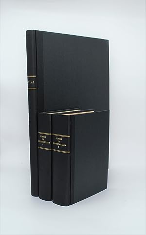
Voyage au Pole Sud et dans l'Océanie sur les corvettes l'Astrolabe et la Zélée, exécuté par ordre du roi pendant les années 1837, 1838, 1839, 1840. 22 (of 23) text-volumes (in 19) and 6 atlas-volumes (in 4) in 23 volumes.
Edité par Paris, Gide et Baudry, 1841-1855., 1855
Vendeur : Manfred Nosbuesch, Kuchenheim, Allemagne
Membre d'association : ILAB VDA
Evaluation du vendeur :

Large 8vo, Large Folio and Imp.-Folio. Text-volumes with 3 plates. Atlas-volumes with 2 frontispieces and 530 (of 533) lithogr. and engr. plates, maps and plans. Contemp. half calf, gilt. Sabin 21216; Nissen ZBI 1200. - Text-volumes: Dumont d'Urville. Histoire du voyage. 10 vols. 1841-1846; Vincendon-Dumoulin et Coupvent-Desbois. Physique. 1842; Vincendon-Dumoulin. Hydrographie. 2 vols. in 1. 1843-1851. 2 plates; Botanique. 2 vols. in 1. Vol. 1: Montagne, M. C. Plantes cellulaires. Vol. 2: Decaisne, J. Description des plantes vasculaires. 1845-1853; Hombron et Jacquinot. Zoologie. Vols. 1-4 (of 5). 1846-1853; Grange, M. J. Géologie, minéralogie et géographie physique du voyage. 2 parts in 1 vol. 1848. 1 plate.; Dumoutier. Anthropologie. 1854. - Atlas Pittoresque: 2 frontispieces, 198 plates and 9 maps. - Atlas Hydrographique: 57 maps. - Atlas Zoologique: 137 (of 140) plates. - Atlas Anthropologie: 50 plates. - Atlas Géologie, Minéralogie: 9 plates and 4 maps. - Atlas Botanique: 66 plates. - Atlas Zoologique lacking 3 plates: Mammifčres, plate 20b: Dugong des Indes, details; Oiseaux, plate 12: Colombe de Félicie; Reptiles, plate 2: Proctotrčte mosaique. - 2 plates loosely inserted: Poissons, plate 4: Centropiste tasmanien and Crustacés, plate 7: Lithode antarctique. - Some occasional browning or staining. A very nice set, uniformely and decoratively bound.
-
Atlas universel de geographie physique, politique, statistique et mineralogique sur l'echelle de 1/1641836 ou d'une ligne par 1900 toises.
Edité par Brussels,, 1827
Vendeur : Daniel Crouch Rare Books Ltd, London, Royaume-Uni
Membre d'association : ABA ILAB PBFA
Evaluation du vendeur :

Livre
An eight metre globe and the first map of the world on a uniform scale. 6 volumes. Folio, 6 letterpress half-titles and title-pages, dedication leaf, 42 pages of text, 'Statistique de l'Europe', 7 lithographed index maps, one of comparative heights with contemporary hand-colour in full, and 382 numbered double-page maps, by Henri Ode, with contemporary hand-colour in outline, some very occasional spotting; contemporary half tree calf, drab paper boards, some wear. The maps in the atlas make up the first map of the world on a uniform scale, constructed as a modified conical projection and, if assembled forming a globe with a diameter of 7.75 metres, although only one such was known to have been made, by the author himself, and requiring a specially designed room. "Philippe Vandermaelen was born in Brussels in 1795, the son of a rich soap manufacturer. After his father's death in 1816, he devoted himself to maps and eleven years later produced this quite remarkable atlas. It was totally at his own expense, and like so many innovations in the past it came about through the single-minded efforts of a man who could afford failure. It offered the largest picture of the earth's surface available in the nineteenth century, thereby giving the lesser known areas such as Australia, South Africa and the West coast of America, all developing countries, a much greater coverage than before. And, perhaps most importantly of all, it was the first atlas to be produced by lithography" (Wardington Catalogue). cf. Koeman III, Vdm 1; NMM 3:179; Philips, Atlases 749.
-
Expédition dans les parties centrales de l'Amérique du Sud, de Rio de Janeiro a Lima, et de Lima au Para; exécutée par ordre du gouvernement Français pendant les années 1843 a 1847. Paris, P. Bertrand, 1850-1859
Edité par P. Duménil, Paris, 1840
Livre Edition originale
Hardcover. Etat : Very Good. First Edition. 7 parts in 13 volumes. 8vo (6 vols.), 4to (6 vols.), folio 1 Vol. With 441 lithographed and tinted lithographed plates and maps, including 401 partly or completely hand-coloured. Original red 3/4 morocco. The most important scientific expedition to South America in the 19th century, led by the French naturalist Francis de Castelnau (1810-1880) First part Histoire du Voyage 8vo, 6Vol. (7), 467pp., 485pp, 483pp, 467pp, 480pp, 432pp folding map. Second part Vues et scenes : 4to, 14pp 59 of 60 engraved plates (lacks #58) Third part Antiquites des Incas : 4to, (4), 7pp, 60 of 62 engraved plates (lacks #19 and #29) Fourth part Itineraires e coupes geologiques :Folio, 8pp, 76 maps, plans and views, partly or completely hand-coloured, Fifth part Geographie des parties centrales : Folio, 10pp, (1), 29 of 30 double page maps (lacks #12) outlined in color and partly hand-coloured Sixth part Botanique : 4to, (1), 90 engraved plates (lacks text and vol 2 of text) Seventh part Vol 1 : Zoologie Animaux, nouveaux ou rares : 4to. Anatomie (8), 100pp, 18 engraved plates (1 hand colored), Mammifčres (2), 116pp 13/20 engins plates (lacks #1 to #7), Oiseaux (2), 98pp, (1), 8/20 engraved plates (lacks #1 to 12). Seventh part Vol 2 Poissons (13), 113pp, 50 engraved plates, Reptiles (1), 95pp, 18 engraved plates. Seventh part Vol 3 Entomologie : 204pp, 20 engraved plates François de Castelnau (December 25, 1810 - February 4, 1880) was a French naturalist, born in London (some sources give his year of birth in 1812). Also known as François Laporte or Francis de Castelnau. Born in London, illegitimate son of the Countess of Mesnard-La Barotičre, daughter of the Duke de La Force, widow after several years. He studied natural history in Paris. From 1837 to 1841 he made a scientific expedition to Canada where he studied the fauna of the Canadian lakes and the political systems of Canada and the United States. From 1843 to 1847, with two botanists and a taxidermist, he crossed South America from Peru to Brazil, following the Amazon River and the La Plata river systems, the scientific results of this expedition are of considerable importance. Besides the zoological, botanical, mineralogical and ethnographical collections he brought to Europe, Castelnau provided a wealth of information with the astronomical, barometrical, hydrographical and hydraulic observations and determinations he made. The beautifully coloured plates make it a desired work for bibliophiles as well. During their travels Castelnau and his men gathered an enormous amount of information through meteorological, magnetic, botanical and zoological observations. He served as a French consul in Bahia in 1848; in Siam from 1848 to 1862, and in Melbourne, Australia from 1864 to 1877, where he died in 1880. Borba de Moraes, pp. 167-168; Howgego, 1800-1850, C14; Nissen, ZBI 88-89; Sabin 11411.
-
Geographischer und Physischer Atlas von Neu-Spanien. gegründet auf astronom: trigonom: und Barometer Messunden [old ink mss.].
Date d'édition : 1812
Vendeur : Altea Antique Maps, London, Royaume-Uni
Membre d'association : ABA ILAB PBFA
Evaluation du vendeur :
Edition originale
Tubingen bey J.C. Cotta, 1810 [old ink mss.]. Folio, contemporary half calf with marbled boards, maroon morocco gilt title label on front board; title in old ink mss on front endpaper. Plates numbered 1-20 (6-8 on one sheet): a two-sheet folding map, 4 double-page maps, 6 single page maps, 4 double-page cross sections with hand colour, 2 sepia aquatint views of volcanos, 1 engraved table. With the bookplate of Gustav Parthey. Two Prussian passports for Parthey, dated 1858 & 1867, loosely inserted. Binding scuffed, contents clean and in very good condition. The complete set of plates from Humboldt's famous 'Atlas Géographique et Physique du Royaume de la Nouvelle-Espagne', the plate volume of his 'Essai politique sur le royaume de la Nouvelle-Espagne'. It has a German translation of the title in manuscript with the name of Cotta, publisher of the true first edition of the 'Essai politique', which was suppressed by Humboldt himself because of a dedication to Charles IV of Spain, who had been forced to abdicate by Napoleon in 1808. The 'Essai politique' was an account of Humboldt's expedition to Mexico in 1803-4 with botanist Aimé Bonpland. During the trip he accurately measured the longitude of Acapulco (plate 18), drew the two-sheet 'Carte Generale du Royaume de la Nouvelle Espagne' the most accurate map of Mexico (and Texas) and the four-sheet profile of Mexico, the first complete profile of any country. The bookplate is of the library of Gustav Friedrich Konstantin Parthey (1798-1872), art historian, owner of the Nicolaische Buchhandlung in Berlin, and correspondent of Humboldt's. He wrote an extensive transcript of Humboldt's 'Kosmos' lectures at the Berlin University, 'Vorlesungen uber physikalische Geographie', 1827-1828. Parthey also compiled a catalogue raisonné of the etchings of Wenceslaus Hollar in 1853, a reference still in use today. He joined Humboldt as a member of the Prussian Academy of Sciences in 1857.
-
Voyage de découvertes aux Terres Australes, exécuté sur les corvettes le Géographe, le Naturaliste, et la goélette le Casuarina, Pendant les années 1800, 1801, 1802, 1803 et 1804 ; sous le commandement du capitaine de vaisseau N. Baudin. Navigation et géographie. Publié par ordre de son excellence le ministre de la marine et des colonies ; et rédigé par M. Louis FREYCINET (Avec un Atlas.)
Edité par A Paris, De L Imprimerie Royale, [1812]-1815., 1815
Vendeur : LIBRAIRIE HÉRODOTE JEAN-LOUIS CECCARINI, Paris, France
Membre d'association : ILAB
Evaluation du vendeur :
Livre Edition originale
Couverture rigide. Etat : Trčs bon. Edition originale. 1 volume in-quarto de texte et atlas in-folio [partie navigation et géographie] ; XVI- 576 pp.-(1)et 1 atlas [595 x 445 mm] imprimé ŕ la date de 1812 se compose ainsi : 1 page de grand titre gravée [écrite par Louis Freycinet et gravée par Lale et Giraldon avec une vignette par Lesueur]-1 f. non chifré [Table des Cartes et Plans]-32 cartes hors texte [1-32]. Un demi-veau glacé havane ŕ petits coins vélin, dos lisse joliment orné, filets or, fleurons or, trčs rare reliure uniforme de l époque car le volume de texte et l atlas ont été édités séparément. ÉDITION ORIGINALE FORT RARE, VOIRE RARISSIME. LE PREMIER ATLAS DE L'AUSTRALIE DRESSÉ PAR LES FRANÇAIS sous le commandement de Nicolas Baudin, capitaine de vaisseau qui accomplit un remarquable travail d exploration de 1800 ŕ 1804 sur les côtes sud et ouest de l Australie alors nommée Terre de Napoléon, ouvrant la voie ŕ une connaissance complčte et exacte des abords de l Australie et de la Tasmanie. Le complément indispensable ŕ la relation de MM. Peron & Freycinet : « Voyage de découvertes aux Terres Australes, A Paris, De l Imprimerie Royale, 1816-17 ». RARISSIME. FIRST EDITION VERY SCARCE.
-
Voyage autour du monde, fait dans les années 1803, 1804, 1805 et 1806, par les ordres de sa majesté impériale Alexandre Ier, empereur de Russie, sur les vaisseux la Nadiejeda et la Neva.
Edité par Paris: Gide fils, 1821, 1821
Vendeur : Peter Harrington. ABA/ ILAB., London, Royaume-Uni
Membre d'association : ABA ILAB PBFA
Evaluation du vendeur :
Edition originale
First edition in French of the first Russian circumnavigation, one of the most significant Pacific voyages after Cook, presented here in superior condition in a choice period binding, complete with the rare atlas of plates, "very important and. difficult to obtain" (Hill). A highly desirable set. Krusenstern (Ivan Fedorovich Kruzenshtern, 1770-1846) had served in the British Navy between 1793 and 1799. He was given command of the two-ship expedition under "a brilliant corps of officers" (Hill), intended to establish trade with China and Japan, facilitate trade in South America, and examine California for a possible colony. His expedition encompassed the Canary Islands, Brazil, the Marquesas, Kamschatka, Nagasaki, Sakhalin, and Macao. "The voyage made a significant contribution to the knowledge of the hydrography of the Pacific coast of North America. Krusenstern took the first Russian embassy of Nikolai Rezanov to Japan" (Howgego). The first edition, published at St Petersburg between 1809 and 1814 with a folio atlas of 105 plates, and issued in both Russian and German, is a signal rarity of travel literature. Editions in Dutch, English and Italian followed, although none were accompanied by a plate volume, which marks the present first edition in French as being the first edition following the original publication to include an atlas of plates. The illustrations are re-drawn versions of images in the original, and includes a portrait of Krusenstern, views and images of native people of the Marquesas, Japan, Sakhalin Island, Kamtchatka, etc., as well as nine maps. The translation is by the French geographer Jean-Baptiste Benoît Eyričs (1776-1846), a founder member of the Société de Géographie, a member of the Société Asiatique and Académie des Inscriptions et Belles-Lettres, awarded the Legion of Honour, and in 1841 elected a Foreign Honorary Member of the American Academy of Arts and Sciences. However, he is best remembered for a non-geographical work: his Fantasmagoriana (1812), an anthology of German ghost stories, was read by the Byron-Shelley circle during their stay at the Villa Diodati, the most famous child of that famous excursion being Mary Shelley's Frankenstein. Arctic Bibliography 9377; Forbes 530; Hill 952; Howes K 272; Lada-Mocarski 61 and 62; Nissen, Zool., 2310; Sabin 38332. 2 octavo volumes letterpress (199 x 123 mm), atlas volume of plates (425 x 280 mm). Contemporary dark green half straight-grain calf, flat spines gilt lettered direct and divided into compartments by zig-zag rolls, two broad panels filled with a reticulated pattern highlighted with a quatrefoil device at the interstices, sailing ship motif in third and sixth compartments, green vellum corner tips, green marbled sides. 30 plates in the atlas, including lithograph portrait of Krusenstern by G. Engelmann after Baptiste, 19 lithograph plates and 10 engraved maps (3 double-page). Vol. I with superficial crack and minor wear at head of front joint, a few light abrasions to spine of atlas, occasional toning and scattered foxing. An excellent set, with the half-titles in the letterpress volumes.
-
Atlas Universel de Geographie Physique, Politique et Historique, Ancienne et Moderne.
Edité par Paris: The Author and Charles Simmonneau, 1822., 1822
Vendeur : Arader Galleries - AraderNYC, New York, NY, Etats-Unis
Evaluation du vendeur :
Folio (21 x 14 4/8 inches). 35 double-page fine engraved maps with contemporary hand-color in outline (except map of France which is coloured in full), each mounted on guards and with vellum finger-tab to the fore-edge (small repair to the map of the United States); EXTRA-ILLUSTRATED with four additional double-page maps inserted at a later date. Original French green roan, gilt (rebacked and with corners renewed to style). Provenance: 20th-century bookplate on the title-page. The list of maps calls for 36 maps including two French maps, west (No. 18) and east (No. 19), but a larger double-page and in part folding map of all France has been substituted for them by the publisher. The atlas was issued with two significant maps of North America, with the cartographic influences of Lewis and Clark clearly evident - "Carte de l'Amerique Septentrionale" dated Janvier 1820 and "Carte Generale des Etats-Unis de l'Amerique Septentrionale" dated December 1820 (Wheat 336), both showing Ft. Clatsop and Ft. Astoria at the mouth of the Columbia, with what was to be Oregon named "Columbia." In Mexico both maps show the province of San Luis Potosi with no mention of Texas. However, in this unusual copy there are two additional maps by Brue, on same size paper as the original maps, apparently inserted later without vellum tabs - "Carte General des Etats-Unis, du Canada et d'une Partie des Pays Adjacent" dated Paris 1825, and "Carte General des Etats-Unis Mexicains et des Provinces-Unies de l'Amerique Centrale" also dated Paris 1825 (Wheat 361), both showing Oregon and Texas and with much more detail in the California Utah region than the original 1820 maps. In addition, at the end of the atlas, inserted and on slightly smaller trimmed paper without vellum tabs, is the title page from Pierre Lapie's "Atlas Universel de Geographie Ancienne et Moderne" followed by two of Lapie's double page maps - "Carte de l'Amerique Septentrionale" dated Paris 1830 and "Carte des Etats-Unis d'Amerique" dated Paris 1832 (Wheat apparently unaware of this 1832 edition, describes the later 1837 edition in Wheat 428), both showing the District of Columbia and Texas and with no mention of Oregon or San Luis Potosi. Also included is Bure's magnificent map of the Pacific: "Oceanie ou Cinquinne Partie du Monde" (1820). First published in 1814, nearly a decade earlier, Brué had taken part in Nicolas Thomas Baudin's (1754-1803) voyage to Australia, at the young age of 15. Considered one of France's most significant expeditions, vast sections of the Australian coastline were charted and thousands of natural specimens were collected. More importantly, this voyage destroyed Dampier's myth that Australia's West coast was barren. Positive reports from the Baudin Expedition paved the way for subsequent French explorers such as Dumont d'Urville and inspired France to consider Western Australia as a convict colony site. Brué worked as a cartographer and publisher during a key period in the history of mapmaking. By the 19th century, previously accepted geographical myths such as Dampier's had been dispelled, allowing cartographers like Brué and his contemporaries such as Aaron Arrowsmith to depict a more truthful and detailed rendering of the world. Brué went on to become one of the most outstanding European mapmakers of his time, garnering the esteemed title of Geographer de Roi. His work is characterized by accuracy and, at moments, genius. Like all of Brué's maps, "Oceanie ou Cinquinne Partie du Monde" is characterized by elegance and restraint. It was issued separately as a wall map in 1814, rendering it a rare and beautiful example of nineteenth century French cartography. Notable territories and other islands delineated include Australia, New Zealand, South China, the Malay Peninsula, Indonesia, New Guinea and the Coral Sea. Coast contours, island groups and harbor details are finely delineated. Phillips Atlases 758 (later 1834 edition). All maps with a small Brue or La.
-
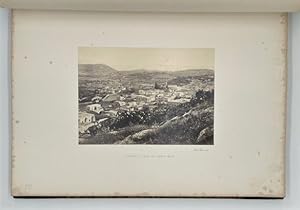
Egypt and Palestine. Photographed and Described. 2 Bände.
Edité par London, James S. Virtue, (1858-1859)., 1859
Vendeur : Versandantiquariat Wolfgang Friebes, Graz, Autriche
Membre d'association : ILAB VDAO
Evaluation du vendeur :
Edition originale Signé
Etat : 0. Erste Ausgabe dieses in 25 Lieferungen erschienenen frühen Fotografiewerks über den Nahen Osten. - Die Fotografien (ca. 14,5 x 16,5 bis 21,5 x 23 cm) tlw. in der Platte signiert u. in der Platte oder der gedruckten Legende meist 1857 datiert. Die Trägerkartons mit typographischer Bezeichnung. - Francis Frith (1822-1898) war der größte Verleger der Ansichtsfotografie seiner Zeit. Vor allem die Aufnahmen seiner drei Orientreisen (1856-1859) begründeten seinen Ruhm. - Francis Frith is undoubtetly one of the best-known photographers to work in the Near East. His trips to the Levant were a brilliant commercial success as well as an artistic one" (Perez). - Neben einem Porträt des Fotografen in orientalischer Tracht mit Aufnahmen aus Abu Simbel, Assuan, Baalbek, Bethlehem, Damaskus, Gizeh, Hebron, Jerusalem, Karnak, Luxor, Nazareth, Philae, Tiberias, Wadi Kardassy u.a. - Einbände etw. berieben u. bestoßen. Vordere Rückenkanten an den oberen Kapitalen etw. angebrochen, oberes Kapital des zweiten Bandes kaum merklich geklebt. Vorderdeckelbezug des ersten Bandes m. Fehlstellen. Vorsatzblätter m. Quetschfalten u. kl. Läsuren. Text schwach gebräunt bzw. fleckig, nur vereinzelt etw. stärker. Die Trägerkartons (bes. Ränder) wie meist unterschiedlich stockfleckig, die überwiegend sauberen Fotografien meist in schönen, kräftigen Abzügen. - Ibrahim-Hilmy I, 249; Travelers in Ancient Lands" S. 193; The Photobook I, 28; Gernsheim, History 286; Blackmer 1942; Hannavy 561; Perez, Focus East 165; Van Haaften/White XII u. XV. Sprache: Englisch Gewicht in Gramm: 10000 Gr.-Fol. (45 x 33 cm). Mit zus. 76 auf Untersatzkartons mont. Orig.-Fotografien (Albumin) von Francis Frith u. 82 nn. Bll. Text. HLdr.-Bde. d. Zt. m. goldgepr. Rückentiteln u. marmor. Schnitt.
-
Viaggio pittorico della Toscana.
Edité par Florenz, Tofani, 1801 - 1803., 1801
Vendeur : Matthaeus Truppe Antiquariat, Graz, Autriche
Membre d'association : ILAB VDAO
Evaluation du vendeur :
Livre Edition originale
3 Bde. VIII, 168; IV, 140; V, 140 S. 204 (4 doppelblattgr.) Aquatinta-Tafeln und 5 doppelblattgr. Kupferstichkarten. Erste Ausgabe dieses schönen und seltenen Ansichtenwerks der Toskana mit den gesuchten Aquatintatafeln von Giovanni Pera nach Antonio Terreni. - Brunet II, 1330. Feltrinelli III, 286: "The plates include a mixture of exterior and interior views, the former almost exclusively after Terreni. Little appears to be known of Terreni, but it seems likely that he is related to Giuseppe Maria Terreni (1739-1811), a native of Livorno, who worked in Florence and established a reputation as a vedutista". - "La lettera dedicatoria č sottoscritta dai fratelli Terreni, che fecero quel viaggio, disegnarono le vedute e le incisero assieme ad altri incisori, fra cui: Vincenzo Soinazzi, Giuseppe Pera, Cosimo Rossi, Giuseppe Politi, Carlo Cecchi e Matteo Carboni. Č una fra le piů importanti ed omogenee raccolte di luoghi toscani oggi quasi del tutto cambiati e documento storico di indiscusso valore. Le vedute, alcune a dopppia pagina, sono fra le piů belle del genere. Le 209 incisioni comprendono: 1 carta coreografica della Toscana, 9 piante (4 cititŕ: Firenze, Pisa, Livorno, Siena; 5 edifici fiorentini e 199 vedute dei piů svariati paesi e ecittŕ della Toscana" (www.gonnelli.it zum Nachdruck von 1972). Leicht gebräunt und fleckig. Buchblöcke leicht angebrochen. Exlibris *** *** Copyright: Matthaeus TRUPPE Buchhandlung & Antiquariat - Stubenberggasse 7 - A-8010 Graz - ++43 (0)316 - 829552 *** *** Sprache: Deutsch Gewicht in Gramm: 0 Gr.-Fol. Pp. der Zeit (beschabt und bestoßen) mit eingebundenem vorderen OU.
-
Voyage pittoresque en Autriche. - (Und:) Précis historique de la guerre entre la France et l Autriche en 1809.
Edité par Paris, Didot, 1821 - 1822., 1821
Vendeur : Matthaeus Truppe Antiquariat, Graz, Autriche
Membre d'association : ILAB VDAO
Evaluation du vendeur :
Livre Edition originale
3 Bde. 2 Bll., IV, 220 S., 1 Bl.; 2 Bll., IV, 106 S.; 3 Bll., 156 S. mit 3 Titelvignette und 27 Textabb. (alles in Aquatinta). 156 Aquatintas auf 116 Tafeln und 3 doppelblattgroße Kupferstichkarten. Erste Ausgabe des wohl schönsten topographischen Werkes über Österreich aus dem 19. Jahrhundert, mit dem oft fehlenden 3. Band über die napoleonischen Kriege in Österreich. - Nebehay/W. 348 u. 349. - Das Werk erschien in der vorliegenden nichtkolorierten Ausgabe und in einer kolorierten Luxusausgabe auf Velin-Papier. - "Das prächtige dreibändige Werk gilt als erstes großes illustriertes Kompendium, das die Schönheiten der österreichischen Landschaft international vorstellte. Graf Laborde war Archäologe, Schriftsteller und Diplomat und kam 1809 im Gefolge Napoleons nach Wien. Nachdem er zum Wiener Kongreß wieder nach Österreich kam, besuchte er Jakob Gauermann in Miesenbach, um ihn als Hauptmitarbeiter für das geplante Werk zu gewinnen. Gauermann weigerte sich zwar, mit Laborde nach Paris zu gehen, malte aber im Gebiet um Schneeberg und Gutenstein Arbeitsszenen der Waldbauern. Die meisten Stiche stammen von Benedikt Piringer, einem Meister der Aquatinta-Technik. Piringer ging dann mit Laborde nach Paris und kam zu hohen Ehren. Labordes Text vergleicht immer wieder die Schweiz mit den österreichischen Alpen. Dabei bemängelt der Franzose das mangelnde österreichische Bewußtsein für eigene Schönheit." (Wolfgang Kos). - Neben der literarischen Beschreibung der niederösterreichischen Landschaft und des napoleonischen Krieges zwischen Österreich und Frankreich ist das Werk aufgrund der bereits erwähnten prachtvollen Ansichten von Baden, Kaiserebersdorf, Heiligenkreuz, Klosterneuburg, Laxenburg, Lobau, Schönbrunn, Schneeberg, Deutsch-Wagram, Wiener Neustadt, Wien usw. sehr gesucht. Die Tafeln wurden nach Entwürfen von Isabey, Janscha, Gauermann, Moreau, Schütz usw. von Piringer, Schwarz u. a. gestochen. - Schönes breitrandiges Exemplar, teils stockfleckig. Die ersten Bll. von Bd. 1 mit braunem Wasserfleck im weißen Rand. Unbeschnitten. *** *** Copyright: Matthaeus TRUPPE Buchhandlung & Antiquariat - Stubenberggasse 7 - A-8010 Graz - ++43 (0)316 - 829552 *** *** Sprache: Deutsch Gewicht in Gramm: 0 Gr.-Fol. Grünes HLdr. des 19. Jahrhunderts mit roten Rückenschildern (berieben und etw. bestoßen).
-
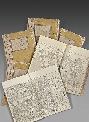
Description illustrée des lieux célčbres de la Chine).
Date d'édition : 1806
Vendeur : Librairie Camille Sourget, Paris, France
Membre d'association : ILAB
Evaluation du vendeur :

Couverture rigide. Etat : Trčs bon. ?saka, Kawachiya Kichibei, Bunka 3 [1806] année du tigre, ??????.6 volumes in-4 imprimés sur papier japonais de riz. Les tomes sont chiffrés en chinois. Le texte est imprimé en sino-japonais avec des notations afin de faciliter la lecture aux Japonais. Cachet rouge de propriétaire au début de chaque volume.Conservés dans leurs brochures beiges japonaises d'origine avec titres d'origine, un titre imprimé et la table des matičres de chaque volume collés sur les plats supérieurs, sutures probablement renouvelées. Défauts mineurs aux couvertures. Etui de protection japonais moderne de toile bleue. Reliure de l'époque.255 x 183 mm. --- Trčs rare édition originale de cette superbe description des lieux célčbres de la Chine sous la dynastie Qing.H. Kerlen, 1996, Catalogue of Pre-Meiji Japanese books and maps in public collections in the Netherlands, n°1077, E. Kraft, Japanische Handschrift und Traditionelle Drucke aus der Zeit vor 1868, I, 1982, n°511 et II, 1986, n°360; Bibliotheca Wittockiana, Western Travelers in China Discovering the Middle Kingdom (2009), n°54; Beijing in Ancient Maps, 2010, pp. 132-145, (Compiled by the National Library of China, Surveying and Mapping Press)."Le genre des Meisho-zue nait au Japon a la fin du XVIIIe sičcle. Gravures et texte concourent au recensement de l'histoire locale et du patrimoine des villes traversées par les voyageurs. Destinés ŕ vulgariser l'histoire des lieux, ŕ faciliter l'appropriation topographique et intellectuelle de la géographie du pays, ils connurent un large succčs."(V. Béranger, La réception des Meisho-zu dans la France du XIXe sičcle.)« Meisho-zue : dénomination des livres illustrés qui décrivent les paysages et présentent l'histoire des lieux célčbres de Kyôto, Edo et quelques provinces. Ils furent publiés vers la fin de l'époque d'Edo. L'origine de ce genre d'ouvrage remonte aux guides des lieux célčbres (meisho-ki) écrits au début de l'époque d /// ?saka, Kawachiya Kichibei, Bunka 3 [1806] year of the tiger, ??????.Six 4to volumes [255 x 183 mm] printed on Japanese rice paper. The volumes are numbered in Chinese. The text is printed in sino-Japanese with notes to ease the reading to the Japanese. Red stamp of the owner at the beginning of each volume. Preserved in their original beige Japanese wrappers with original titles, one printed title and the table of content of each volume pasted on the front cover, stitches probably renewed. Minor defects to the wrappers. Japanese protective book case in modern blue fabric. Contemporary binding. --- Very rare first edition of this superb description of China's famous places under the Qing dynasty.H. Kerlen, 1996, Catalogue of Pre-Meiji Japanese books and maps in public collections in the Netherlands, n°1077, E. Kraft, Japanische Handschrift und Traditionelle Drucke aus der Zeit vor 1868, I, 1982, n°511 and II, 1986, n°360; Bibliotheca Wittockiana, Western Travelers in China Discovering the Middle Kingdom (2009), n°54; Beijing in Ancient Maps, 2010, pp. 132-145, (Compiled by the National Library of China, Surveying and Mapping Press)."The Meisho-zue genre was born in Japan at the end of the 18th century. Engravings and text contribute to the inventory of local history and the heritage of the towns visited by travelers."(V. Béranger, La réception des Meisho-zu dans la France du XIXe sičcle.)"Meisho-zue: name of the illustrated books which describe the landscapes and present the history of Kyôto's famous places, as well as Edo's and other provinces. They were published towards the end of the Edo period. The origin of this kind of book goes back to the guides of famous places (meisho-ki) written at the beginning of the Edo period.By comparing the meisho-zue to the meisho-ki, we notice that there are more images that become more important than verbal descriptions. Illustrations are realistic and were influenced by the genre painting?" (Seiich.
-
Neue Untersuchungen ueber die physicalische Geographie und die Geologie der Alpen. Textband und Atlas. Zus. 2 Bde.
Edité par Leipzig, T.O. Weigel, 1854,, 1854
Vendeur : Harteveld Rare Books Ltd., Fribourg, Suisse
Membre d'association : ILAB VEBUKU
Evaluation du vendeur :
Edition originale
imp.-Fol. (55 x 39 cm) und in-4to, XVI + 639 S. + 1 Falttab. / 2 Bl. (Titel, und Verzeichnis der Tafeln) + 22 meist farbige lithograph. Tafeln davon 3 doppelblattgr. + 8 Umrisstafeln (zu Tafel 7-9, 11-14, und 20) + 8 Bl., teils stockfleckig, Textband in Original-Broschur & Tafelband. Tafeln lose eingelegt in Original-Umschlag (dieser etwas gebraucht und mit kl. Randeinrissen). Erste Ausgabe des sehr seltenen und sehr gesuchten Standardwerkes mit den grossartigen Ansichten und Panoramen in einem wohlerhaltenen Gesamtexemplar. Textband und Atlas mit insges. 30 Tafeln: 22 teils getönte und kolorierte Lithographien, meist prachtvolle Gebirgspanoramen, davon 3 doppelblattgross: Karte des Monte-Rosa und seiner Umgebung (Lith. Anstalt Kraats Berlin) / Ansicht des Monte-Rosa und des Gorner Gletschers (lithogr. v. A. Haun) / Vergleichende Darstellung der physikalischen Verhältnisse der Alpen; dazu 4 Karten-Tafeln, 4 Tafeln mit Profilen und einigen Instrumenten, 3 Tabellen-Tafeln, und 8 Erläuterungsblätter der landschaftlichen Ansichten. ?Das Werk behandelt weitgehend die Schweizer Alpen, mit Darstellungen vor allem aus dem Wallis (Monte-Rosa), dem Berner Oberland, doch auch aus Ober-Bayern. Die topographische Karte des Monte-Rosa (Tafel 1), wurde von Herrn H. Lange mit vorzüglicher Sorgfalt in einem Blatte gezeichnet .? (Vorwort zum Textband). Zum Zweck wissenschaftlicher Untersuchungen und Messungen hatten die Brüder Adolf & Hermann Schlagintweit, von denen einer später auf einer Expedition in Indien auf tragische Art und Weise von erbosten Einheimischen enthauptet wurde, 1851 die zweite Ersteigung des Grenzgipfels Monte-Rosa ausgeführt und damit als erste Touristen überhaupt diese Region betreten. Im gleichen Jahr erreichten sie auch die Vincentpyramide und überschritten erstmals das Fillarjoch in der Weisstorkette. Die Brüder waren die ersten deutschen Forscher, die in den Westalpen hochtouristisch hervortraten. Durch ihre gründlichen Untersuchungen haben sie sich in ihren Bemühungen um eine vollständige Erforschung des Monte-Rosa-Stockes hohes Verdienst erworben. Das Ergebnis ihrer wissenschaftlichen und touristischen Tätigkeit in den Schweizer Alpen ist in ihrem das Gesamtgebiet der Alpen umfassenden grossartigen Werk ?Neue Untersuchungen, etc.? niedergelegt. Im folgenden ein auszugsweises Verzeichnis einiger der prachtvollen lithographischen Ansichten:Ansicht des Monte-Rosa und des Gorner-Gletschers,Ansicht des Alpenzuges vom Monte-Cervin bis zum Mettelhorn,Das untere Ende des Gornergletschers,Ansicht der Vincentpyramide,Die oberste Felsenkuppe des Monte-Rosa,Die Vincenthütte am Col delle Piscie,Ansicht des Monte-Rosa und der Lyss-Kamm,Vergleichende Darstellung der physikalischen Verhältnisse der Alpen, etc. etc. Please notify before visiting to see a book. Prices are excl. VAT/TVA (only Switzerland) & postage. BMC (nat. Hist.) IV, 1837; Lehner, Eroberung der Alpen, pp. 341 ff.; Graf BSL II/51; Perret 3951, Wäber 82 & 218; Interlibrum Katalog 314: Berühmte Schweizer Forscher (1987); Dreyer 251; Poggendorff I, 802.
-
Edo Meisho zue. (= Illustration des sites célčbres de la ville d'Edo).
Date d'édition : 1834
Vendeur : Librairie Camille Sourget, Paris, France
Membre d'association : ILAB
Evaluation du vendeur :
Couverture rigide. Etat : Trčs bon. Tokyo, Suwaraya Ihachi, Tenpo 5- Tenpo 7, [1834-1836].20 volumes in-4 sur papier japonais de riz ou de műrier. Conservés dans leurs brochures d'origine bleues ŕ motifs gaufrés de branches de pins, pičce de titre sur le plat supérieur de chaque volume, sutures probablement renouvelées. Deux étuis modernes de toile beige. Reliure de l'époque. 258 x 170 mm. --- Édition originale de la meilleure description de la ville d'Edo (l'actuelle Tokyo), la plus grande ville du monde au milieu du XIXe sičcle. H. Kerlen, Catalogue of Pre-Meiji Japanese Books and Maps in Public Collections in the Netherlands, Amsterdam, 1996, n 224; V. Béranger, Recueils Illustrés des Lieux Célčbres, Ebisu, Tokyo, 2002, pp. 81-113; T. Screech, The Western Scientific Gaze and Popular Imagery in Later Edo Japan, Cambridge Univ. Press, 1996. "Le genre des Meisho-zue nait au Japon a la fin du XVIIIe sičcle. Gravures et texte concourent au recensement de l'histoire locale et du patrimoine des villes traversées par les voyageurs. Destinés ŕ vulgariser l'histoire des lieux, ŕ faciliter l'appropriation topographique et intellectuelle de la géographie du pays, ils connurent un large succčs."(V. Béranger, La réception des Meisho-zu dans la France du XIXe sičcle.) « Meisho-zue : dénomination des livres illustrés qui décrivent les paysages et présentent l'histoire des lieux célčbres de Kyôto, Edo et quelques provinces. Ils furent publiés vers la fin de l'époque d'Edo. L'origine de ce genre d'ouvrage remonte aux guides des lieux célčbres (meisho-ki) écrits au début de l'époque d'Edo. Si on compare le meisho-zue au meisho-ki, on remarque que les images y sont plus nombreuses et ont plus d'importance que les descriptions verbales. Les illustrations sont réalistes et ont subi l'empreinte de la peinture de genre? Les Meisho Zue les plus connus sont le ?Yamato Meisho Zue', ?l'Ise Sangu Meisho zue' et ?l'Edo Meisho zue' sur Edo (1836). » (Seiichi Iwao, Dictionn /// Tokyo, Suwaraya Ihachi, Tenpo 5- Tenpo 7, [1834-1836].20 4to volumes [258 x 170 mm] on Japanese rice or mulberry tree paper. Preserved in their contemporary blue wrappers with pine branches embossed patterns, lettering piece on the upper cover of each volume, probably renewed stitches. Two modern beige cloth cases. Contemporary binding. --- First edition of the best description of the city of Edo (the current Tokyo), the largest city in the world in the middle of the 19th century. H. Kerlen, Catalogue of Pre-Meiji Japanese Books and Maps in Public Collections in the Netherlands, Amsterdam, 1996, n 224; V. Béranger, Recueils Illustrés des Lieux Célčbres, Ebisu, Tokyo, 2002, pp. 81-113; T. Screech, The Western Scientific Gaze and Popular Imagery in Later Edo Japan, Cambridge Univ. Press, 1996. "The genre of the Meisho-zue starts in Japan at the end of the 18th century. Engravings and text contribute to the count of local history and of heritage of the towns crossed by travelers. Aimed at popularizing the history of places, at facilitating the topographic and intellectual appropriation of the country's geography, they were very successful." (V. Béranger, La réception des Meisho-zu dans la France du XIXe sičcle.) "Meisho-zue: name of the illustrated books that describe the landscapes and present the history of the famous places in Kyôto, Edo and some provinces. They were published around the end of the Edo area. The origin of this kind of work dates back to the guides of the famous places (meisho-ki) written at the beginning of the Edo area. If we compare meisho-zue to meisho-ki, we can notice that the pictures are more numerous in the first one and have more importance than the verbal descriptions. The illustrations are realist and have suffered the influence of the genre painting? The most famous Meisho Zue collections are the ?Yamato Meisho Zue', the ?Ise Sangu Meisho zue' and the ?Edo Meisho zue' about Edo (1836)." (Seiichi Iwao, Dictionnaire.
-
Voyage pittoresque et historique de l`Istrie et dela Dalmatie, redige d`apres l`itineraire de L(ouis) F(rancois) Cassas.
Edité par Paris, Didot für Nee,, 1802
Vendeur : Matthaeus Truppe Antiquariat, Graz, Autriche
Membre d'association : ILAB VDAO
Evaluation du vendeur :
Livre Edition originale
2 Bll., VIII, 190 S., 1 Bl. (Errata). 1 Frontispiz, 1 Titel, 1 doppelblattgr. Karte und 66 (9 gefalt.) Tafeln (alles in Kupferstich). Erste Ausgabe dieses wohl schönsten Buches über Istrien und Dalmatien in einem französischen Meistereinband von Jean-Claude Bozerian. - Graesse IV, 512. Nebehay-W. 358. Blackmer 296. Cohen-De Ricci 205. - The French painter Louis-François Cassas travelled the East Adriatic coast from Istria to Southern Dalmatia in 1782 where he was commissioned to make drawings of the antiquities in the area by `une societe d`amateurs des beaux arts`. On that occasion he drew numerous sketches which were later reproduced to copperplate printing in the book og Joseph Lavallee "Voyage pittoresque et historique de l`Istrie et de la Damatie". His sketches of Dalmatia represent an exceptionally valuable source for getting to know its towns as it was at the end of the 18th century, both in architectural and archaelogical sense. - Ein nur stellenw. leicht gebräuntes und fleckiges Exemplar in einem signierten Einband des führenden französischen Buchbinders - Jean-Claude Bozerian - der Zeit Napoleons. *** *** Copyright: Matthaeus TRUPPE Buchhandlung & Antiquariat - Stubenberggasse 7 - A-8010 Graz - ++43 (0)316 - 829552 *** *** Sprache: Deutsch Gewicht in Gramm: 0 Gr.-Fol. Rotes Maroquin von J.-C. Bozerian mit reicher Rücken- und Deckelvergoldung, sowie vergoldeten Steh- und Innenkanten und dreiseitigem Goldschnitt (leicht beschabt und bestoßen).
-
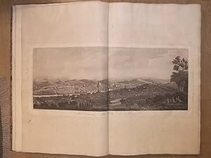
Voyage pittoresque et historique de l'Espagne. 2 in 4 Bänden.
Edité par Paris, P. Didot L'Ainé, 1806-1820., 1820
Vendeur : Versandantiquariat Wolfgang Friebes, Graz, Autriche
Membre d'association : ILAB VDAO
Evaluation du vendeur :
Edition originale
Etat : 0. Erstausgabe dieses prächtigen monumentalen Ansichten- und Reisewerkes über Spanien, vorliegend in einem schönen, vollständigen Exemplar. - Laborde chose Spain as his subject, not only because of his firsthand knowledge of the country, but because it was one of the leastknown regions to that date, with a variety of monuments, an interesting history, rich natural resources, and a strong cultural inheritance [.]. Laborde began his studies accompanied by a ,troop of draftsmen who travelled with him to all the ancient cities throughout the Spanish peninsula. They sketched and measured Arab monuments and buildings of the Middle Ages and the Renaissance and classified his collection methodically by province, period, style, and influence. The results [.] are a monumental, comprehensive, encyclopedic report, in which are recorded many monuments that now have disappeared [.]. The high quality engravings cover a range of subjects, from fragments of ancient floor tiles to street scenes, cathedral interiors, and views of nature and natural phenomena. The detailed records of architecture, antiquities, decorative arts and utensils, and Moorish inscriptions are of much archaeological value" (Millard Coll. S. 219f.) - Mit dem Portrait des Prince de la Paix", dem späteren Ferdinand VII. von Spanien, dem das Werk gewidmet ist. Die Tafeln mit schönen Kupferansichten von Barcelona, San Felipe, Chulilla, Merida, Sevilla, Alicante, Badajos, Montesa, Tarragona, Lerida, Gibraltar, Valladolid, Madrid usw., aber auch Plänen, Kostümdarstellungen und Genreszenen, antiken Gebäuden, Ausgrabungen usw. - Einbände (Rücken) tlw. leicht berieben bzw. bestoßen. Schuber tlw. etw. bestoßen u. an den Kanten mit Leinen verstärkt. Portrait neu angefalzt. 2 Tafeln mit leichtem Papierbruch im Plattenrand. 2 Tafeln verbunden. Eine Tafel im seitlichen weißen Rand m. restaurierter Fehlstelle. Die Textblätter im äußeren seitlichen weißen Rand m. winzigem (herstellungsbedingtem?) Einstich. Tlw. leicht gebräunt bzw. stockfleckig. - Palau 128975; Brunet III, 713; Vicaire IV, 742; Monglond VII, 243; Millard Coll. 83; Ornamentstich-Slg. Bln. 2769. Sprache: Französisch Gewicht in Gramm: 20000 Gr.-Fol. Mit gest. Titel, einem gest. Porträt, 4 gest. Titelvignetten, 2 doppelblattgr. Kupferkarten u. 349 tlw. ganzs. Kupfern auf 272 Tafeln. Zus. ca. 400 S., Ldr.-Bde. d. frühen 20. Jhds. a. 5 Bünden m. ornamentaler Deckelverg. u. goldgepr. Rückentiteln in HLdr.-Schubern (61 x 47 cm).
-
Helvetischer Almanach für das Jahr 1799 bis 1822. In 24 Bden.
Edité par Zürich, Orell, Füssli, 1799-1822,, 1822
Vendeur : Harteveld Rare Books Ltd., Fribourg, Suisse
Membre d'association : ILAB VEBUKU
Evaluation du vendeur :
in-12mo, mit 24 gest. Titeln, 9 (4 alt-kol.) Aquatinta-Taf., 43 Kupfertafeln, 69 altkol. gest. Trachtentafeln, 96 gefalt. gest. Ansichten, 3 (1 gefalt., 2 altkol.) gest. Profile, 5 gefalt. Tabellen u. 1 gefalt. Musikbeilage, 24 altkol. gefalt. Kupferkarten (gest. v. J. Scheurman), Bibl.-sign. Lassberg. Illustr. Orig.-Pappbde, teilw. etwas berieben, Rücken v. Jg. 1799 ersetzt. Neu hergestelltes Papp-Ausstellkästchen. Ausserordentlich seltene komplette Folge des unter verschiedenen Titeln erschienenen Almanachs, (u.a. Revolutionsalmanach). Nachfolger des in 19 Jahrgängen veröffentlichten ?Helvetischen Calenders? Unter den vielen Almanachen und Taschenbüchern der Zeit fiel der ?Helvetische Almanach? durch seine sorgfältige Ausstattung und reiche Illustrierung auf. Dennoch scheint die Reihe, ihrer engen thematischen Ausrichtung entsprechend, nur in der Schweiz verbreitet gewesen zu sein. (HAB, Kalender 174). Die Texte geben meist eine geographisch-statistische Beschreibung der Kantone, ferner poetische Beiträge von F. Brun, C. Grass, J. Hottinger, H. Keller, J.R. Wyss u.a. Mit sauber kolorierten Schweizer Trachtendarstellungen u. Karten der Schweizer Kantone sowie fein gestochenen Ansichten von Basel, Bern, Biel, Genf, Neuchâtel,Thun, Wintertur, Zürich, Freiburg und zahlr. kl. Alpen-Orten u. Landschaften. Unter den Künstlern Hegi, Hess, Koenig, Lips, J.H. Meyer etc. Meist leicht gebräunt u. ein wenig stockfleckig. Die vom Verleger nur lose beigelegte und sehr seltene Kte des Kantons Luzern in Jg. 1822 hier auch vorhanden. Please notify before visiting to see a book. Prices are excl. VAT/TVA (only Switzerland) & postage. Köhring 12, 15 u. 98; Goedecke VIII, 51,13; BCF 36; Wäber BSL III/14-15; cf. Lonchamp 59.
-
Manuscript map and engraved publisher's proof: "Colonie Anglaise de Victoria ou Australia Felix."
Edité par Nouvelle Annales des Voyages Series VI, November 1856., 1856
Vendeur : Arader Galleries - AraderNYC, New York, NY, Etats-Unis
Evaluation du vendeur :
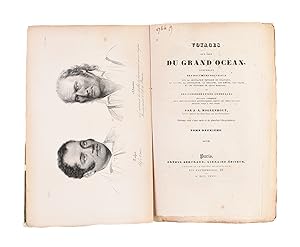
2 maps: single sheets matted (7 x 8 5/8 inches to the neat line; sheet size 9 x 11 inches / 10 x 13 5/8 inches). Fine manuscript map in black and red ink with blue and brown colour washes on map-maker's tracing paper (browned, edges frayed). [With:] Engraved publisher's proof of "Colonie Anglaise de Victoria ou Australia Felix.", corrected in red ink by Malte-Brun. A fine manuscript map, with accompanying engraved proof with corrections, in minute detail showing the Australian state of Victoria with an inset of the entire continent in the top right-hand corner. Published for inclusion in Malte-Brun's successful journal "Nouvelles Annales des Voyages, de la Geographie et de l'Histoire, ou Recueil des Relations originales inedites, communiquees par des voyageurs Francais et Etrangers; des Voyages nouveaux traduits de toutes les langues Europennes." Paris: Gide Fils. 1819-1870 in six series in 208 octavo volumes to 1866 when the title changed to "Annales des Voyages" (Sabin 56093). Victor Adolphe Malte-Brun was a French geographer and cartographer, and the son of Conrad Malte-Brun, Danish geographer and founder of the Société de Géographie. Victor Adolphe, followed the steps of his father and became a member of the Société de Géographie in 1851, and quickly rose to be its secretary-general. The Société de Géographie is the world's oldest geographical society founded in December of 1821. Among its 217 founders were some of the greatest scientific names of the time: Pierre-Simon Laplace, the Society's first president; Georges Cuvier, Alexander von Humboldt , Charles Pierre Chapsal, etc . Other founding members had accompanied Napoleon Bonaparte during his Egyptian expedition; among them Conrad Malte-Brun, Jules Dumont d'Urville, Jules Paul Benjamin Delessert, Hottinguer, Henri Didot, Bottin and others. The Society's Revue has enjoyed a long history of publication, beginning with a monthly issue titled "Bulletin de la Société de Géographie", issued 1822-1899. The periodical featured early discoveries of the nineteenth century. Victor Adolphe Malte-Brun took over the position of editor from his father, and created all maps used in the magazine after the most up-to-date information directly supplied by the great explorers of the day. The Society's library, map collection and photograph collection are among the World's most comprehensive.
-
Oriental Album. Characters, Costumes, and Modes of Life, in the Valley of the Nile.
Edité par James Madden, London, 1851
Etat : Gut. 2. Auflage. Gut. Folio (40-45 cm). 3 Bll., 60 S. Halbleder der Zeit über fünf Bünden mit montiertem Rückenschild, goldgeprägter Rückenverzierung und Ganzkopfgoldschnitt 2. Auflage. Einband an den Kanten berieben, Vorsätze im Falz mit grünem Textilband verstärkt, Seiten etwas gebräunt und fleckig, Papier an den Rändern aufgrund der Alterung mit Ausfransungen und Läsuren, insgesamt gut erhalten. Atabey 1001. Blackmer 1357. Colas 2427. OCLC 4423031. Zweite Auflage des äußerst seltenen und gesuchten Werkes über den Nil in Ägypten (Menschen, Charaktere, Bräuche, Kleidung, Kostüme, Lebensweisen, Alltagskultur) von der Hand des berühmten französischen Ägyptologen und Archäologen Émile Prisse d'Avesnes (1807-1879), ergänzt durch die Texte des englischen Ägyptologen und Orientalisten James Augustus St. John (1795-1875). Mit 31 ganzseitigen getönten und weißgehöhten Lithographien sowie einer Titelvignette. Reisebericht, Reisebeschreibung, Tavelogue, Ägypten, Egypt, Ansichten, Veduten, Druckgraphik, Grafik, illustriertes Werk, Ägyptologie, Nile, 19. Jahrhundert. 10000 Gramm. Halbleder der Zeit über fünf Bünden mit montiertem Rückenschild, goldgeprägter Rückenverzierung und Ganzkopfgoldschnitt.
-
Aquarelle. Auf seiner Reise um die Erde nach der Natur aufgenommen in Egypten, Indien, China, Japan, Manilla, Amerika etc. etc. Textheft u. Tafelband in 2 Bänden.
Edité par Berlin, R. Wagner, (1871-1874)., 1874
Vendeur : Versandantiquariat Wolfgang Friebes, Graz, Autriche
Membre d'association : ILAB VDAO
Evaluation du vendeur :
Edition originale
Etat : 0. Erstausgabe mit dem beiliegenden Textband von Robert Weisse (Kl.-8°, 76 S., OKart.). - Vollständige Folge dieser prachtvollen farbigen Chromolithographien (ca. 27 x 18 bis 38 x 27 cm) mit Ansichten von Alexandria, Bangkok (2), Benares, Bombay, Colombo, Hongkong, Kairo (2), Macao (3), Manila, Nagasaki, Peking (2), Rangoon (Goldene Pagode u. Arbeitselefant), San Francisco (2; darunter eine schöne Straßenansicht mit Dampfomnibus), Singapur, Suez, Tientsin, Yokohama etc. Die Darstellungen sind im Bild bezeichnet, die Kartons verso zudem m. den gedruckten Titelschildchen des Verlags. - Hildebrandt (1818-1869) war ein Schüler des Marinemalers Wilhelm Krause in Berlin, wo er schon früh das Interesse Alexander v. Humboldts erregte. Auf dessen Empfehlung hin hatte König Friedrich Wilhelm IV. Hildebrandt in den Jahren 1844/45 nach Brasilien und in die Vereinigten Staaten von Amerika gesandt. Weitere Reisen folgten, und 1862-1864 unternahm der Künstler eine Reise um die Welt, die ihn von Italien über den Nahen Osten und Ägypten nach Indien, China und Japan, dann über den Stillen Ozean nach Kalifornien, Mittelamerika und schließlich England führte. Auf dieser Reise entstanden mehr als 400 Aquarellstudien, von denen hier einige der schönsten in ausgezeichneten Faksimiles wiedergegeben werden. "Als Aquarellist kann sich Hildebrandt kühn neben die besten Deutschlands, Englands oder Frankreichs stellen; freilich war er in ununterbrochener Übung, was ihm jedoch ohne angeborenes Genie wenig geholfen hätte" (ADB).- Der schwere Einband berieben u. bestoßen. Laschen erneuert. Untersatzkartons meist, die Darstellungen nur vereinzelt (stock-)fleckig. Der Lieferungsumschlag (mit dem Aufdruck Das Werk ist nunmehr vollständig erschienen" u. Complet!") m. Läsuren. Textband fleckig u. mit Unterstreichungen bzw. Marginalien. - Thieme/B. XVII, 74f.; ADB XII, 402. ge Gewicht in Gramm: 20000 Imp.-Fol. (62 x 53 cm). Mit 34 chromolithogr. Farbtafeln v. R. Steinbock (27) u. W. Loeillot (7) nach Eduard Hildebrandt, vom Verlag auf Untersatzkartons montiert. Zus. m. dem letzten Orig.-Lieferungsumschlag lose in schwarz- u. goldgepr. illustr. OLwd.-Mappe.
-
Konvolut von 26 Original-Fotografien aus dem Dachsteingebiet
Edité par Fotografien Albuminabzüge Aufgenommen von Dr Friedrich Simony und 1886, 1885
Signé
24 Fotos ca. 19 x 25 cm (bzw. 25 x 19 cm) auf Karton aufgezogen (diese ca. 30 x 41 cm) sowie 2 Panoramafotos ca. 25 x 39 cm (zweigeteilt auf faltbarem Karton ca. 35 x 54 cm aufgezogen), alle im Negativ signiert FSy 85 (oder 86), Albuminabzüge, kontrastreich und gut erhalten. Friedrich Simony schrieb in 196 Publikationen seine Erkenntnisse als Geograph, Geomorphologe, Paläontologe und Meteorologe nieder. Für diese Werke und für seine Lehrtätigkeit als Universitätsprofessor war es ihm ein großes Anliegen, selbst als begabter Zeichner, Maler und Fotograf, Bilder herzustellen. Er ist ein wichtiger Wegbereiter für die darstellenden Methoden in der Geographie und des Lehrunterrichts. Seine pädagogischen Ziele konnte er auch im Rahmen des Bildungsauftrags von Museen, wie etwa als erster Kustos des Naturhistorischen Museums in Klagenfurt, umsetzen. Im Salzkammergut ist Simony vor allem als "Dachsteinpionier" bekannt und zahlreiche Orte und Straßen tragen seinen Namen. Alpinisten als auch Landschaftspfleger haben ihm viel zu verdanken. Simonys Aufnahmen können wissenschaftlichen als auch künstlerisch-ästhetischen Ansprüchen gerecht werden. Seine Forschungen inspirierten nicht nur Adelbert Stifters Novelle "Bergkristall", ihm war auch der Nutzen seiner Bilder als Vorlagen für Gebirgsmaler bewusst. Genauso könnten seine Bilder zur Ankurbelung des Alpintourismus beigetragen haben. Simony war dem österreichischen Alpenverein seit dem Gründungsjahr 1862 angehörig und lieferte Bildvorlagen für die "Zeitschrift des Deutschen und Österreichischen Alpenvereins." Der Verein finanzierte u. a. seinen geschützten Beobachtungsort beim Karlseisfeld, die Simonyhütte. Das Konvolut stellt eine einzigartige Gelegenheit dar, Originalfotos von Friedrich Simony zu erstehen. 3475 gr.
-
Documents sur l'histoire, la géographie et le commerce de l'Afrique Orientale. Premičre partie. Publiés par ordre du gouvernement. Exposé critique des diverses notions acquises sur l'Afrique Orientale depuis les temps reculés jusqu'ŕ nos jours. [vol. 1]. Deuxičme partie. Relation du voyage d'exploration ŕ la cote orientale de l'Afrique, exécuté pendant les années 1846, 1847 et 1848, par le brick le Ducouëdic. [Vol. 2 et 3]. Album lithographié par MM. Bayot, E. Ciceri, J. Jacottet, Sabatier et Vogt d'aprčs les épreuves daguerriennes de MM. Caraguel et Bridet enseignes de vaisseau. [Atlas].
Edité par Paris, Arthus Bertrand, [1856-1857]. 1856, 1857
Vendeur : JF LETENNEUR LIVRES RARES, Saint Briac sur mer, France
Membre d'association : ILAB
Evaluation du vendeur :
Signé
3 vol. de texte in-8° (240 x 158 mm) et 1 atlas in-plano (538 x 355 mm) de : I : xxxi, 628 pp.et 1 carte gravée face ŕ la p. 103, 1 tableau p. 127 et 1 tableau de généalogie dépliant relié face ŕ la p. 624; II : xxiii, 556 pp.; III : [2] ff. (f.t., t.), 527 pp. ( dont : 2 tableaux d observations météorologiques sur double page pp 82-83 et 190-191, des tableaux dans le texte, et un appendice comportant un « petit vocabulaire français et Soumali ») ; Atlas : [1] ff. de titre, 1 « carte générale du voyage » dépliante et 54 planches numérotées de 2 ŕ 27 et 27 bis ŕ 54 dont : 10 cartes gravées ( 4 sur double page et 6 ŕ pleine page) et 45 planches de lithographies teintées (dont 1 sur double page, 40 ŕ pleine page et 3 avec 2 gravures par page donnant un total de 48 gravures). Ces lithographies sont signées Bayot, Ciceri, Jacottet, Sabatier et Vogt d'aprčs des dessins et des daguerréotypes de Caraguel et Bridet représentant des vues, paysages, navires et des sujets ethnographiques. (Mention manuscrite «Souvenir de l'auteur» sur la page de garde du vol 1 et initiales sur les titres répétées dans les vol 2 et 3. Rousseurs, taches ou petites traces de mouillures surtout dans les marges). Demi-chagrin bleu nuit, dos ŕ faux nerfs ornés et titrés ŕ l'or, plats recouverts de papier gaufré imitant le chagrin (d'époque pour le texte, ŕ l'imitation pour l'atlas). Rare exemplaire de cet ouvrage consacré ŕ l Afrique orientale, ŕ ses côtes, ŕ Zanzibar et aux autres iles, ŕ ses relations avec l Arabie et au récit du voyage d'exploration du brick le Ducouëdic en 1846, 1847 et 1848 dans cette région. Ensemble illustré d un atlas exceptionnel pour le réalisme de ses planches lithographiées utilisant l innovation technique naissante du daguerréotype. Son auteur, Charles Guillain, entre dans la marine ŕ l'âge de quatorze ans et gravie les échelons pour finir gouverneur de la Nouvelle-Calédonie, commandant en chef de la division navale et contre-amiral. Le premier volume est consacré ŕ son exposé critique abondamment documenté sur les relations économiques et géopolitiques de l Afrique de l Est depuis l antiquité : les arabes, les Hebreux, les Phéniciens, les Grecs, les Romains, la fondation par les Arabes des petits états indépendants, l arrivée des Portugais dont la domination est supplantée par les Arabes d Oman. Avec une large partie consacrée au Sultana d Oman et ŕ Zanzibar. Les volumes deux et trois renferment la relation du voyage : En 1846, le ministčre des Affaires étrangčres et le ministčre du Commerce confient ŕ Guillain le commandement du navire le Ducouedic pour une mission d'étude sur les côtes de l'Afrique orientale. Durant les escales, il pénčtre dans l'arričre-pays et étudie la géographie physique et les populations locales, notamment Swahili et Somali. Aprčs un séjour prolongé ŕ Zanzibar, la mission regagne la France par le Cap. Le rapport de son voyage de deux années est remis par Guillain ŕ l amirauté en 1850. Le navire visite successivement : la Réunion, Zanzibar, Surate, Bombay, Socotra, Abd-el-Kouri, Hhafoun, Soumal-Medjeurtine, Moguedchou, Djeziret, Seychelles, ile Bourbon, Maiotte, Meurka, Monbase Avec de nombreux tableaux et appendices contenant divers documents, dont le traité entre les Français et le sultan de Mascate, des tableaux d observations météorologiques et un « petit vocabulaire français et Soumali ». L atlas est constitué de cartes hydrographiques et de lithographies teintées gravées par MM. Bayot, E. Ciceri, J. Jacottet, Sabatier et Vogt d'aprčs les daguerréotypes réalisés pendant le voyage par les enseignes de vaisseau Caraguel et Bridet. En cela cet album constitue un des premiers exemples de cette innovation technique toute récente qui donne aux sujets représentés, notamment les populations, une exactitude et un réalisme ŕ l époque inégalés. Il s ouvre sur 2 cartes générales gravées du voyage ŕ laquelle s ajoute 9 cartes ŕ pleine ou double page pour l hydrographie. Les 45 planches lithographies (dont 1 sur double page, 40 ŕ pleine page et 3 avec 2 gravures par page donnant un total de 48 gravures). Ils représentant des vues, paysages, navires et des sujets ethnographiques. Liste des planches : 1 et 2. Carte générale du voyage, deux feuilles. 3. Vue de Dzaoudzi (l'un des îlots voisins do Maďotte) en 1846.4 Vue de la ville do Zanzibar, prise du mouillage. 4. Vue de la ville de Zanzibar vue du mouillage. 5. Vue de M'tony, résidence de campagne du Sultan. 6. Arabes de Zanzibar. 7. Divers types Souahhéli, de Zanzibar, Lamou, Mombase et Patta. 8. Femmes Souahhéli, vues de face et de profil. 9. Plan do la ville de Zanzibar. 10. Soldais irréguliers du Sultan (Arabes d Omân de la tribu des Beni-m -hhacen). 11. Vue de la partie est et de la forteresse de l îlo de Diou, prise du mouillage extérieur. 12. Vue de la forteresse de Diou, prise de la maison du gouverneur. 13 Vue d une partie de la ville de Diou, prise des remparts do la citadelle. 14. Profil d une partie de la ville de Pangim. 15. Carte de file d Abd-el-Kouri. Mouillage de la côte sud d Ŕbd-el-Kouri (*). 16. Cases d Abd-el-Kouri. 17. Carte et mouillage de la presqu île de Hhafoun (*). 18. Types de Soumal-Medjeurtine, face et profil. 19. Une femme Medjeurtine. Une fille Mcdjcurtine. 20. Jeune fillo Medjeurtine. Femme Ouarsanguéli, face et profil. Femme Medjeurtine tressant sa natte. 21. Soumali en voyage portant le cassc-téte et la bouteille ŕ ablutions. Soumali armé de l arc et du carquois. Soumali armé de la sagaie et du bouclier. 22. Vue de la ville de Moguedehou , prise du mouillage en dehors du récif. 23. Panorama de Moguedehou, vue prise de la terrasse de notre maison. 24. Moulin ŕ huile en mouvement, et travaux divers exécutés ŕ Moguedehou. 25. Départ de notre caravane pour Guéledi. 26. Vue de Guéledi sur la rivičre Denoq. 27. Vue du village de Djelieub. Vue du village de Djéziret. 27 bis. Vue du village de Gondeurcheikh. 28. Vue de Moutsamoudou, ville principale de Hic d Anjouan. 29. Syed Soliman Ben Ahhmed, gouv.
-
Carte géographique de l'Egypte et des pays environnans. Réduite d'aprčs la carte topographique levée pendant l'expédition de l'armée française. Gravée au dépot général de la Guerre. Publiée par ordre du Gouvernement.
Edité par Paris., 1818
Vendeur : Biblion Antiquariat, Zürich, ZH, Suisse
Membre d'association : GIAQ ILAB VEBUKU
Evaluation du vendeur :
Edition originale
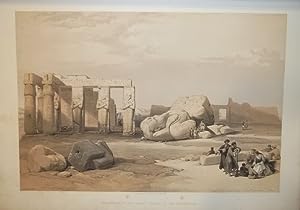
Imp.-Folio. 3 doppelblattgr. Tafeln mit Titel und Übersichtskarte, 2 gestoch. Bl. mit weiterer Übersichtskarte und Kartenerläuterungen, 47 (41 doppelblattgr.) Kupferkarten. HLdr.-Bd. der Zeit über 7 Bünden, schöne Rückenvergoldung. Erste Ausgabe. - Eines der bedeutendsten Werke der französischen Kartographie im 19. Jahrhundert. Der Atlas wurde bereits 1807 fertigestellt. Napoleon verhinderte die Publikation zu diesem Zeitpunkt aus Geheimhaltungsgründen. Er wurde dann 1818 im Zusammenhang mit dem Monumentalwerk "Description de l'Egypte", das die wissenschaftlichen Ergebnisse der französischen Armee zusammenfasste, veröffentlicht. Mit diesem Kartenwerk wurde das Gebiet des heutigen Ägyptens, Teile des Sudans und Libyens sowie Syriens zum ersten mal mittels Feldvermessungen kartographiert. - Sehr vereinezelte, kleine schwache Stockflecken. Sehr schönes, wohl kaum berührtes, breitrandiges, unbeschnittenes und auf starkem Bütten gedrucktes Exemplar. Zeitgenössischer Einband mit mehrfachen goldgeprägter Deckelfiletierung, Kapitalvergoldung mit 3 Zickzackmustern, über 7 breiten Bünden mit Bundfilette in Gold. Das feine Halbleder mit violettem Schimmer. Alle 4 Ecken mit breitem Lederschutz. Mit schönen altmarmorierten Vorsätzen, ein Bijou! - Imperial-Folio. Wit 3 engr. double-page plates with title and general map, 2 engr. leaves with another general map and explanation, 47 (41 double-page) engraved maps. Contemporary light pink three quarter morocco, back on seven raised bands, spine gilt, marbled endpapers. - First edition in a fine untrimmed copy. One of the most important works in 19th century French cartography. Already finished in 1807 by Pierre Jacotin, the colonel in charge of the topographical section of the French army, the publication of the atlas was forbade by Napoleon for security reasons. It was finally published together with the monumental text volumes of the "Description de l'Egypte", embodying the scientific results of Nopoleon's expedition to Egypt. The atlas maps the region of modern Egypt, parts of Sudan, Lybia and Syria, for the first time by triangulation and topographic survey. - Apart of some minor light foxing here and there an excellent preserved, almost untouched copy on heavy paper, with wide margins. - In A neat copy of this rarity.
-
Voyage de Dentrecasteaux, envoyé ŕ la recherche de La Pérouse. Publié par ordre de sa Majesté l Empereur et Roi, sous le ministčre de S. E. le vice-amiral Decrčs, comte de l Empire. Rédigé par M. de (Édouard de) Rossel, ancien capitaine de vaisseau.
Edité par Dépôt général des Cartes et Plans de la Marine et des Colonies, Imprimerie Impériale,, 1807
Vendeur : Librairie Voyage et Exploration, Cerny, France
Evaluation du vendeur :
Livre Edition originale
Couverture rigide. Etat : Bon. Edition originale. RARE ENSEMBLE COMPLET en 3 volumes TEXTE ; 2 forts vol. in-4° ; (2)-LVI-704 pp.-32 pl. h.-t. repliées in-fine (I-XXXII)/(2)-VIII-692 pp.-1 pl. h.-t. Repliée sur papier bleuté , relié demi cuir (reliure moderne), dos lisse avec titre et tomaison , tranches mouchetées , mouillure angulaire sur 7 planches, petites rousseurs sur les planches . ATLAS ; 1 volume grand in-folio (560x445) ,page de titre-1 fnch. (Table )-39 cartes et vues h.-t. , dont 29 ŕ double page ,dressées par l'ingénieur hydrographe C. F. Beautemps Beaupré et gravées sur cuivre par E. Collin , relié demi cuir , dos lisse ,cachets répétés , petites rousseurs . Édition originale de la relation du voyage de Bruny d'Entrecasteaux, envoyé par Louis XVI en Océanie ŕ la recherche de La Pérouse. Sa rédaction a été confiée au capitaine de vaisseau Rossel, qui s'est appuyé sur le journal laissé par d'Entrecasteaux, emporté par le scorbut au cours du trajet. Elle est illustrée de 33 planches dépliantes dans les volumes de texte et de 39 cartes et vues dans l atlas , réalisées pendant l'expédition et qui étaient d'un niveau exceptionnellement élevé, en particuliers les 12 magnifiques cartes de l'Australie occidentale et de la Tasmanie qui enregistraient la côte avec précision pour la premičre fois , la nouvelle méthode de Beautemps-Beaupré , révolutionna la cartographie . En février 1791, inquiet du sort de l'expédition commandée par La Pérouse, qui aurait dű ętre rentrée en France depuis plusieurs mois, Louis XVI fit envoyer deux frégates ŕ sa recherche, symboliquement rebaptisées La Recherche et L'Espérance. Cette ambitieuse expédition quitta Brest en septembre, doubla le cap de Bonne-Espérance, visita plusieurs îles du Pacifique sud (la Tasmanie, la Nouvelle-Zélande, la Nouvelle-Calédonie, les îles Tonga, le Vanuatu, etc.) et se termina de façon chaotique ŕ Sourabaya, un des principaux établissements hollandais situés sur l'île de Java. L'équipage y arriva diminué par la fatigue et la maladie , alors que la France avait changé de régime et était en guerre avec l Angleterre, sans avoir trouvé la moindre trace de La Pérouse. Hormis son issue malheureuse, l'expédition fit des découvertes importantes dans le domaine de la géographie, de l'hydrographie et des sciences naturelles, et rapporta une liste de vocabulaires des peuples qu'elle rencontra (voir les pages 557-590 du premier volume). UN RÉCIT TRČS RARE D'UN VOYAGE D'UNE IMPORTANCE ÉNORME POUR L'EXPLORATION DE L'AUSTRALIE ET DU PACIFIQUE Antoine Reymond Joseph de Bruni d'Entrecasteaux, dit le « chevalier d'Entrecasteaux » , entre dans la marine ŕ l age de 15 ans , combattit ŕ Minorque , accompagna Chabert dans ses expéditions scientifique , prend le commandement de la flotte française dans l océan indien , ouvre une nouvelle route de navigation vers la Chine , il devient gouverneur des Mascareignes jusqu ŕ sa nomination ŕ la direction de l expédition ŕ la recherche de La Pérouse en 1791. Charles-François Beautemps-Beaupré, (Neuville-au-Pont 1766, Paris 1854), est un ingénieur hydrographe et cartographe français, membre de l'Académie des sciences et du Bureau des longitudes . Il est considéré comme le pčre de l'hydrographie moderne . Chadenat, n°5056. , Sabin, n°22671 FIRST EDITION. D'Entrecasteaux joined the French navy in 1754 and fought in 1756 at Minorca. He assumed command of the French fleet of the East Indies and in 1787, was appointed governor of Mauritius and the Isle of Bourbon. While in command in search for La Perouse in 1791-92, he determined the position of Amsterdam Island, explored the coastlines of New Caledonia, Tasmania, and New Holland, and located several groups of islands. Many of the charts made by the expedition (particularly those of South Australia produced by Beautemp Beaupre) were of unusually high standards, and the 12 magnificent maps of Western Australia and Tasmania recorded the coast accurately for the first time. They are regarded the most significant ever made. A VERY RARE ACCOUNT OF A VO.
-
Mission Pavie Indo-Chine 1879-1895.
Edité par Ernest Leroux, Editeur, Paris,, 1898
Vendeur : The Isseido Booksellers, ABAJ, ILAB, Tokyo, Japon
Membre d'association : ILAB
Evaluation du vendeur :
Livre
Hardcover. Etat : Good. First ed. 4to. 11 vols. 3 frontispieces. Numerous plates & text-illus., some in color. 82 maps, some in color. Original wr. bound in contemporary half morocco, marble boards, gilt decorated on spine and top edge, except Vol. VI and VII, slightly worn, internally slightly water stained of Etudes Diverses, Vol. III. A very scarce set. Etudes Diverses. I & II: Recherches sur la Litterature du Cambodge, du Laos et du Siam. III: Resertures sur l'histoire naturelle de l'Indo-Chine. Geographie et Voyages. I & II: Expose des Travaux de la Mission. III: Voyages au Laos et chez les sauvages du sud-est de l'Indo-chine. IV: Voyages au centre de l'Annam et du Laos et dans les regions sauvages de l'Est de l'Indo-Chine. V: Voyages dans le haut Laos et sur les frontieres de Chine et de Birmanie. VI: Passage du Me-Khong au Tonkin (1887 et 1888). VII: Journal de marche (1888-1889), evenements du Siam (1891-1893). With Atlas. Notices et cartes.
-
Mémoires de physique et de Chimie - 1807/1817 -- EDITION ORIGINALE -- BEL EXEMPLAIRE -- 3 VOLUMES (COMPLETE SET)
Edité par P., Bernard, 1807/1817, 1807
Edition originale
Couverture rigide. Etat : Trčs bon. Edition originale. ---- EDITION ORIGINALE ---- RARE ---- BEL EXEMPLAIRE provenant de la bibliothčque de la Société de Jésus dont le fonds scientifique fut vendu ŕ l'hôtel Drouot en 1984 ---- P., Bernard, 1807/1817, 3 VOLUMES in 8 reliés en pleine basane racinée, dos ornés de fers et filets dorés, étiquettes de titres et de tomaisons rouge, tranches jaspées (reliures de l'époque), (cachets de la bibliothčque de la société de Jésus dans la marge des pages de titres dont le fonds scientifique fut vendu ŕ l'hotel Drouot en 1984), T.1 : (2), 4pp., 382pp., 1 TABLEAU DEPLIANT, 1 PLANCHE DEPLIANTE, T.2 : 3 feuillets non chiffrés, pp. 6/498, 1 TABLEAU DEPLIANT, 2 PLANCHES, T.3 : 6pp., (1), 618pp., 1 TABLEAU DEPLIANT ---- EN FRANCAIS DANS LE TEXTE N° 215 : "En 1807, BERTHOLLET fonde avec LAPLACE la Société d'Arcueil qui se réunit réguličrement pour discuter des grands problčmes scientifiques de l'époque. LA SOCIETE D'ARCUEIL a regroupé les savants les plus éminents de cette premičre moitié du XIXe sičcle et, malgré sa durée trčs courte, CELLE-CI DOIT ETRE RETENUE COMME LE HAUT LIEU DE LA SCIENCE DE CETTE EPOQUE. Une simple liste des savants membres de la Société d'Arcueil suffit ŕ témoigner de son importance : BERTHOLLET, LAPLACE, Alexandre de HUMBOLDT, J.B. BIOT, THENARD, GAY-LUSSAC, Pyrame de CANDOLLE, COLLET-DESCOLTILS, Amédée Barthélémy BERTHOLLET (le fils), Etienne-Louis MALUS, François ARAGO, J.E. BERARD, CHAPTAL, Pierre-Louis DULNG, Siméon-Denis POISSON. La collaboration d'un tel groupe de savant fut trčs fructueuse et donna lieu ŕ un grand nombre de travaux en commun. A THENARD et GAY-LUSSAC, nous devons la préparation du sodium et du potassium en grande quantité par des moyens chimies ; ŕ HUMBOLDT et GAY-LUSSAC des études sur le magnétisme terrestre. En 1808, GAY-LUSSAC donne sa loi sur la combinaison des gaz en volume, selon laquelle les gaz se combinent entre eux avec des rapports volumétriqaues simples. Une grande partie du premier volume est consacrée aux travaux de THENARD sur les éthers et sur la bile. MALUS découvre la polarisation de la lumičre par réflexion. HUMBOLDT étudie la géographie des plantes. BIOT publie un mémoire sur la vitesse du son. DULONG découvre le chlorure d'azote" ---- NORMAN N° 1971**76390/7639/ARB3.
-
Album mit 32 teils großformatigen Entwurfsplänen für den Bau einer Festungsanlage bzw. einer Lafette.
Edité par (Schweden -07), 1806
Vendeur : Antiquariat Gerhard Gruber, Heilbronn, Allemagne
Membre d'association : ILAB VDA
Evaluation du vendeur :
Livre
(32 x 52 cm). Mit 32 teils gefalteten Blättern (28,5 x 47 bis 46 x 58 cm), davon 20 Bll. mit mehrfarbig aquarellierten Federzeichnungen, 9 Bll. mit Federzeichnungen, teils in farbiger Tinte, und 3 Bll. mit schematischen Federzeichnungen. Dunkelbrauner Halblederband um 1900. Das großformatige Album ist ein sehr schönes und bedeutendes Dokument der Festungsbaukunst aus der Zeit um 1800 in Schweden, geschaffen von einem künstlerisch mehr als nur begabten Militär, der aus einer alten schwedischen Adelsfamilie, einem Grafengeschlecht, stammte und als Höfling des schwedischen Königs diente: Gustaf Lewenhaupt (1780-1844). Seine militärische Karriere begann er 1794 in der Kavallerie, 1795 studierte er an der Universität Uppsala, und im Jahr 1800 wurde Lewenhaupt Major und Oberadjutant in der Armee. 1807 wurde er schließlich vom Militärdienst befreit. Unmittelbar davor war der vorliegende, vortrefflich, sehr exakt und sauber gezeichnete, in seinen Ansichten auch höchst dekorative Plansatz entstanden. Dieser scheint eine Art Probestück gewesen zu sein, geschaffen um unter Beweis zu stellen, dass der Entwerfer mit allen Planungsaufgaben der Festungsarchitektur vertraut ist, angefangen von einfachen Schemata und diversen Waffendetails, über Konstruktionen, bis hin zu ganzen Bauteilen der Verteidigungsanlagen und Bastionen; den dekorativ-anschaulichen Höhepunkt bilden gar zwei Ansichten eines Kirchenbaus. Alle Blätter wurden offenbar von offizieller Stelle abgenommen und approbiert, denn sie tragen sämtlich an der oberen rechten Ecke Bemerkungen über ihre Qualität - die durchwegs sehr gut ausfallen - ein Datum und eine Signatur von der Hand des Prüfers. Zwischen der Entstehung, die Lewenhaupt auf einigen der Blätter links oben vermerkt hat, und der Prüfung lagen immer einige Wochen, die Blätter datieren aus der zweiten Hälfte des Jahres 1806 bis ins Frühjahr 1807, die gewöhnlich datierte Abnahme erfolgte vom September 1806 bis April 1807. Auf einem Blatt hat Lewenhaupt zudem vermerkt, dass die Zeichnungen in seiner freien Zeit entstanden sind. Akribie, feine Schattierungen bei den gegenständlichen Zeichnungen, Genauigkeit in jedem Detail und große Anschaulichkeit zeichnet die Blätter durchgehend aus. Es handelt sich hier wohl nicht um Entwürfe für ein konkretes Projekt zur Verwirklichung - wiewohl das nicht auszuschließen ist - sondern um den Beweis Lewenhaupts, ein fähiger und mit allen Aufgaben vertrauter Militärarchitekt zu sein. Dementsprechend findet sich unter unseren Blättern ein ganzes Spektrum verschiedener Gebäude und Objekte, die für eine Festungsanlage relevant sind: Blockhäuser in Verbindung mit Wallanlagen, die Mauern einer Bastion mit Galeriegängen, die Anlage der Bastion von oben (nicht nur als Grundriss, sondern in beeindruckender Vogelschau) und ihre Fassade mit Toren, zwei imposante Darstellungen einer Festungskapelle, ein für die Zeit altertümlich wirkendes Gebäude, das an viel frühere Wehrkirchen erinnert und damit allerdings der Bauaufgabe angemessen ist, ein "Aprocher" mit einem Teil des Grundrisses der Festung und den Stellungen der Belagerer, diverse Grundrisse von Festungsbauwerken, ein Schnitt durch eine ganze Schanzenanlage der Belagerer, Kanonenrohre und Lafetten (teils aus früherer Verwendung, so etwa eine aus der Zeit König Friedrichs mit der Jahreszahl 1736), dargestellt in einer ganzen Reihe von Skizzen, weiterhin Skalen und Schemata über die Reichweite und Wirkung diverser Geschütze der Artillerie. Mehrere Zeichnungen sind an Vorlagen des großen schwedischen Architekten Carl Johan Cronstedt (1709-1779) orientiert ("efter Presidenten Baron Cronstedts Maner"). - Das Album wurde wohl in der Zeit um 1900 aus ungebundenem, unterschiedlich großem Planmaterial zusammengestellt. Wir können also keine Aussage darüber machen, ob es vollständig ist oder nur einen Teil eines größeren Konvoluts bildet. Doch ist es wahrscheinlich, dass es sich hier um die in dieser Zeit noch im Besitz der Familie Lewenhaupt befindlichen Pläne handelt, denn auf den vorderen Spiegel findet sich ein hochovaler Stempel mit einem auf einer Konsole stehenden Löwen, sicherlich das Wappen eines Zweigs dieser Familie. - Auf feinem und gutem Bütten mit den Wasserzeichen "Honig & Zoonen" sowie "J Kool". - Die meisten Blätter sehr sauber, nur sehr vereinzelt gering fleckig und gebräunt.
-
Voyages aux îles du Grand Océan,
Date d'édition : 1837
Vendeur : Maggs Bros. Ltd ABA, ILAB, PBFA, BA, London, Royaume-Uni
Membre d'association : ABA ILAB PBFA
Evaluation du vendeur :
Edition originale
Contenant des Documents Nouveaux sur la Géographie, Physique et Politique, La Langue, La Litterature, La Religion, Les Moers, Les Usages et Les Coutumes de Leurs Habitants' et des Considerations Générales sur Leur Commerce, Leur Histoire et Leur Gouvernment, depuis les temps le plus reculés jusqu'a nos jours. First edition. 2 vols. Folding map & 4 lithograph plates. 8vo. A very good copy in publisher's printed wrappers, some sporadic light foxing. xv, 576; vii, 520pp. Paris, Rare in the original wrappers, this notoriously uncommon book was written by a Belgian trader who settled in Tahiti in the late 1820s. The author made four principal voyages throughout the South Pacific, and his book is packed with interesting detail, arranged island by island. He had a particularly keen eye for the customs of the Polynesians and collected valuable historical information as he travelled. For instance there is a fascinating account of a conversation with Adams on Pitcairn, the last remaining Bounty mutineer, in 1829 three months before his death, together with a long description of the island and its inhabitants. He was also instrumental in the Pritchard affair which was a key event in the French annexation of Tahiti. Moerenhout was also a good artist and one of the portraits in the book is of John Adams. Some of his drawings were used to illustrate Tahiti in the Atlas Pittoresque for Dupetit-Thouar?s voyage of the Vénus. Hill, 1170; Forbes, 1065; Sabin, 49829.
-
Ansichten steyerischer Gegenden, Heilbäder und Ortschaften gezeichnet von Carl Reichert. Herausgegeben von Anton Burger, Graz" (Textheft).
Edité par Graz, Anton Burger, o. J. (1858-1862)., 1862
Vendeur : Versandantiquariat Wolfgang Friebes, Graz, Autriche
Membre d'association : ILAB VDAO
Evaluation du vendeur :
Edition originale
Etat : 0. Erstausgabe. - Vollständiges Exemplar der sogenannten Burger schen Suite" mit allen 138 Ansichten, 2 zusätzlichen Varianten, einer alten Fotografie einer weiteren Variante u. einem handschriftl. Textheft (mit Erläuterungen zum Entstehen der Ansichten-Folge sowie einem Inhaltsverzeichnis; wohl um 1900 geschrieben). - Diese Sammlung steyerischer Ansichten [.] wurde [.] von 1858 bis 1862 herausgegeben. Dieselbe umfasst in ihrer Gesamtheit 138 Ansichten und 3 Varianten in Stahlstichen in der Größe von beiläufig 12 x 8 cm [Blattgröße ca. 17,4 x 22,2 cm] [.]. Sie war ursprünglich nicht als zusammenhängende Ansichtenfolge gedacht, sondern hauptsächlich als Ansichten für Briefköpfe von Heilbädern und Gegenden Steyermarks. Nach und nach wurde sie dann in geografischer Hinsicht vervollkomnet [.]" (Textheft). - Die Tafeln Nebehay/W. 8, 26 (diese als Photographie) u. 34 liegen in jeweils zwei Varianten vor. 3 Tafeln (61, 66 u. 100) alt koloriert. Tafel 103 ( Villa Aichelburg in Neuhaus") war überklebt mit Villa Maryland in Neuhaus"; diese Überklebung wurde wieder abgelöst und darunter montiert. Ein Teil der Tafeln ist etwas beschnitten und auf Untersatzkartons montiert, eine Tafel (17) ist bis zur Darstellung beschnitten, aufgezogen u. handschriftl. bezeichnet. - Ränder tlw. etw. bestoßen. Zwei Tafeln m. kl. Eckknicken. Tlw. etw. gebräunt bzw. stockfleckig (nur wenige Tafeln stärker). - Insgesamt schönes Exemplar dieser vollständig äußerst seltenen Ansichtenfolge. - Nebehay/W. 535 (unter Ansichten aus der Steiermark., um 1860. Kein Titelblatt"). ge Gewicht in Gramm: 2000 Qu.-Gr.-8°. 140 Tafeln in Stahlstich u. ein handschriftl. Textheft (Titel, 12 S. u. ein weißes Bl.), lose in Pp.-Umschlag u. Pp.-Schuber m. gedrucktem Deckelschild ( Ansichten aus Steyermark. Verlag: A. Burger, Graz").

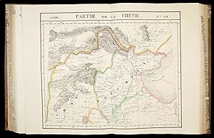

![Image du vendeur pour Geographischer und Physischer Atlas von Neu-Spanien. gegründet auf astronom: trigonom: und Barometer Messunden [old ink mss.]. mis en vente par Altea Antique Maps](https://pictures.abebooks.com/inventory/md/md31449501850.jpg)