
Montant total (1 article articles) :
Destination de la commande :

geographie, Couverture rigide (Plus de 179 000 résultats)
Passer aux résultats principaux de la recherche
Type d'article
- Tous les types d'articles
- Livres (177 547)
- Magazines & Périodiques (70)
- Bandes dessinées (4)
- Partitions de musique
- Art, Affiches et Gravures (38)
- Photographies (12)
- Cartes (1 725)
-
Manuscrits &
Papiers anciens (23)
Etat
Reliure
- Toutes
- Couverture rigide
- Couverture souple
Particularités
- Edition originale (10 939)
- Signé (1 523)
- Jaquette (38 176)
- Avec images (122 308)
- Sans impression ŕ la demande (165 185)
Livraison gratuite
Pays
Evaluation du vendeur
-
Cartes de Geographie Les plus Nouvelles et les plus Fideles
Edité par Paris: Chez l'Auteur, 1679., 1679
Vendeur : Arader Galleries - AraderNYC, New York, NY, Etats-Unis
Evaluation du vendeur :

Edition originale
Du VAL, Pierre (1619-1683). Cartes de Geographie Les plus Nouvelles et les plus fideles, Avecque leurs Divisions Regulieres, qui marquent les Bornes des Estats selon les derniers Traites de Paix. Paris: Chez l'Auteur, 1679. Folio (17 x 12 2/8 inches). Engraved "Introduction", "Alphabet et Definition des Termes", "Table Generale de Geographie", "Les Tables de Geographie reduites en un Jeu de Cartes" and two sheets of a games related to the German Empire (uncoloured), and one of place-names for Les Conciles; engraved allegorical title-page, fine double-page engraved double-hemisphere world map "Planisphere, ou Carte Generale de Monde", "Carte Universelle du Commerce", 1677 (Shirley 465, second state), and 89 double-page engraved maps, all with original hand-colour in outline. 19th-century tree sheep backed marbled paper boards, the spine in six compartments, with five raised bands, the second with maroon morocco lettering-piece, the others decorated with fine gilt tools (extremities a little scuffed, small abrasion to lower cover). Provenance: with 19th-century marginal manuscript scholarly annotations to L'Amerique autrement le Nouveau et Indes Occidentales Du Val's EXTREMELY RARE "Cartes Geographiques" (Pastoureau Duval II), was the only folio atlas published by him. It was initially a collection of du Val's own maps, with those of other authors, published in 1654, then 1665 and 1667. In 1677 du Val published a uniform collection of his grand four-part wall, and folio maps, with the allegorical frontispiece as here: an architectural border supporting two putti unveiling a large globe to a world of assorted grandees; beneath the pillared arch repose a gentleman traveller, a merchant with this bags of salt and pepper, a scientist illuminating his own hand, and a curious woman tending to her animals. The maps in this example of the "Cartes Geographiques" are EXCEPTIONALLY FINE, bright, clean and attractive examples, with original hand-colouring in outline, and include 2 world maps, double-hemisphere and on a Mercaor projection, 7 of his spectacular wall maps, 3 sheets of games, that seem to be the equivalent of our "Risk", and 89 detailed double-page maps, each detailed, but also beautiful for their elegant simplicity. Pierre du Val was the nephew of the celebrated French cartographer Nicolas Sanson d'Abbeville (1600-1667), mapmaker to Louis XIV, King of France, and responsible for sparking a renaissance in geographical endeavor in France, and laying the foundations for French domination in map production, initiating the so-called "French school of cartography," a school that was unprecedented in its attention to precision and scientific detail and which discarded much of the decorative embellishments of previous maps as irrelevant. Du Val adopted Sanson's geographical conceptions, confirming that the center of cartographic innovation had shifted from Holland to France. Du Val too was appointed to the position of Geographe ordinaire to Louis XIV, and justifiably so. The maps include, in order: - World maps: Planisphere, ou Carte Generale de Monde (Duval II D), double-hemisphere world map, surrounded by diagrams showing compass points, winds and planetary orbits, a small terrestrial globe and an armillary sphere - Carte Universelle du Commerce, Carte Hidrographique, ou. Les Costes des 4 Parties du Monde, Avecque les Routes pour la Navigation des Indes, Occidentales et Orientales 1677 (Shirley 465, second state, first published in 1674), on Mercator s projection showing the French and English routes to and from the East and West Indies, complete with galleons in full sail, the track of Le Maire across the Pacific, and an anonymous attempt to find a route to China and Japan through Hudson s Bay in 1665. This map perpetuates the myth that California is an island, and displays some of the misunderstandings about the largely unexplored northwest coast of North America, such as the Straits of Anian. The lower half of the map is do.
-

Geographie opus nouissima traductione e Grecorum archetypis castigatissime pressum
Edité par Johann Schott, 1513
Vendeur : Arader Galleries - AraderNYC, New York, NY, Etats-Unis
Evaluation du vendeur :
Livre Edition originale
Hardcover. Etat : Near Fine. 1st Edition. THE DuPONT COPY. Folio (18 1/2 x 12 1/2 in.; 469mm x 317mm). 47 woodcut maps by Martin Waldseemüller (all but 2 double-page) including "Tabula terre nove," the last map ("Lotharingia") printed in colors, 4 woodcut diagrams in text, one large woodcut of an armillary sphere on K1; lower portion of the title-page renewed with 12 lines of text on verso supplied in excellent pen-work facsimile, lower portion of last leaf renewed, without the final blank leaf, some browning and staining, a few leaves skillfully repaired affecting the image in 3 maps: Italy, Switzerland and the Upper Rhineland. Contemporary blind-stamped paneled calf over wooden boards, each cover decorated with alternating fillets of a stag and hunter, and a thistle and bird roll tool, fore-edge lettered in Greek: "Ptolemaio," original vellum page-markers; brass catches and clasps and cornerpieces renewed to style, recently and expertly conserved by James and Stuart Brockman Ltd, full report available upon request. THE FIRST "MODERN" EDITION OF PTOLEMY AND "THE MOST IMPORTANT OF ALL PTOLEMY EDITIONS" (Streeter Sale I:6). The first modern atlas, prepared by Martin Waldseemüller using the translation of Mathias Ringmann. This is one of the most important editions of Ptolemy, containing many new regional maps: twenty new maps based on contemporary knowledge "unlike many of the alleged 'new' maps produced by earlier editors, [they] contained a great deal of new information, and in nearly every case they were decided improvements over anything that had been previously offered" ("The World Encompasssed," 56), and were included in addition to the traditional body of twenty-seven Ptolemaic maps derived from the 1482 Ulm edition (or possibly from the manuscript atlas of Nicolaus Germanus that served as a source for the latter). Schott's edition while initiated by the most famous of all early sixteenth-century cosmographers, Martin Waldseemüller and his associate Mathias Ringmann, partly at the expense of Duke René of Lorraine, was brought to completion by Jacobus Eszler and Georgius Ubelin. THE FIRST MAP IN AN ATLAS ENTIRELY DEVOTED TO AMRERICA. The atlas contains "Tabula terre nove." Often called the "Admiral's map" after Columbus, unlike its predecessor by Peter Martyr, it shows the continental Atlantic seaboard, with a continuous coastline stretching from the mouth of the Rio de la Plata to the St. Lawrence River. Although not to scale the map depicts a complete Gulf of Mexico. The island of Cuba is here named Isabella after Queen Isabella of Spain, who funded Columbus's expedition of 1492. The first issue of Waldseemüller's map published in 1507 introduced for the first time "America" to name South America, but in this atlas issue he acknowledges Columbus's discovery with the legend: "Hec terra cum adiacentib insulis inuenta est per Columbus ianuensem ex mandato Regis Castelle" (This land with its adjacent islands was discovered by Columbus, sent by the king of Castile). The map of Lotharingia (the first map of the Duchy of Lorraine), printed in black, red and olive, is one of the earliest examples of color-printing. This edition was reprinted in 1520 using the same woodcut blocks. REFERENCES: Fairfax Murray, German 348 and 348A; Harrisse 74; Phillips 359; Sabin 66478; Shirley 34 PROVENANCE: Copious contemporary marginal scholarly annotations in Greek and Latin; Pierre S. du Pont III (1911-1988), his sale, (Collection of Navigation, Christie's 8 October 1991, lot 214).
-
Grosser Atlas Uber die Gantze Welt Wie diese sowol, Nach Göttlicher Allweisen Schöpffung aus den heutigen Grund-Sätzen der berühmten Astronomorum Nicolai Copernici und Tychonis de Brahe, In der Bewegung und unermeßlichen Weite Des Himmels, als auch in dem Umfang unserer mit Wasser umgebenen allgemeinen Erd-Kugel, zu betrachten, Samt einer kutzen Einleitung zur Geographie. . .
Edité par Johann Heinrich Gottfried Bieling for die Homannische Erbe, 1737
Vendeur : Arader Galleries - AraderNYC, New York, NY, Etats-Unis
Evaluation du vendeur :
Livre
Hardcover. Etat : Very Good. Five volumes. Folio (20 7/8" x 14 1/8"). Decorative stenciled title-page "Atlas Universalis" in each volume, printed in red and black, and dated 1760, with mss index on verso, vignette title-page for "Grosser Atlas uber die gantze Welt," additional hand-coloured engraved allegorical title-page for "Atlas Novus", fine uncoloured engraved portrait of Homann by Winter, 129 double-page and one full-page town plans, and 320 double-page maps and plates, one double-page leaf with four vignette maps of the continents, by Homann, Lotter, and de Fer, all with original hand-color in full or in part, and with slightly later hand-colour in outline, the majority laid down in full or part at the time of publication, extra-illustrated with double-page world maps by Bellin, 1748 and Lotter, 1778, and four vignette maps of Gibraltar laid-down on the verso of the town plan (small repair to lower corner of map of France, map of Burgundy with small burn affecting the image). Contemporary full mottled calf, the spines gilt in 9 compartments, red morocco lettering-piece in one, gilt-lettered in two (some minor wear to corners, a bit rubbed). With the ink signature "Exchaquet" in an early hand at the head of the title-page in volume one, and the stenciled initials of "F.P.S." at the foot of each title-page. A composite atlas, with 130 town plans and 27 maps and plans of American cities (vol. V). The maps of America importantly include de Fer's map of California dated 1722, Lotter's map of the British colonies dated 1777, as well as his beautiful map of Philadelphia (a complete list is available upon request). The first volume begins with Johann Gabriel Doppelmayr's impressions of Homann's celestial charts as "Atlas Novus Coelestis", Nuremberg: Homann, 1742, with 36 fine engraved double-page maps and plates with original hand-colour in part. The volume continues with maps of Portugal, Spain, France, Great Britain and Belgium and includes magnificent town plans of Lisbon, Madrid, Gibraltar, Barcelona, Paris, Strasbourg, London, Amsterdam, the Hague, Rotterdam, Brussels, D'Anvers, Maastricht, and Luxembourg. Volumes II and III contains the German Empire, including Austria, Bavaria, the old provinces of Franconie and, Souabe, and the Rhine, Westphalia, Saxony, and Switzerland and includes amongst others the town plans of Vienna, Regensburg, Munich, Salzburg, Nuremberg, Augsburg, Stuttgart, Ulm, Frankfurt, Dresden, Leipzig, Hanover, and Hamburg. Volume IV has maps of Italy, Hungary, Bohemia, Silesia (11 double-pages of views), and Poland, and includes town plans of Turin, Milan, Mantua, Parma, Rome, Florence, Venice, Genoa, Naples, Belgrade, Prague, Danzig, Berlin, and Stettin. Volume V has maps of Scandinavia, Russia, Greece, Asia, Africa, and America, and includes town plans of Bratislava, Stockholm, Copenhagen, St. Petersburg, Constantinople, and the cities of Batavia, Jerusalem, Bengal, Oran, Algiers, Porto Belo, Lotter's Plan of Philadelphia, maps of Halifax and Quebec. Homann is arguably the most important figure in German cartographical history. This atlas, is a testament to the creativity and cartographical skill that earned Homann such prestige within European map-making circles. Homann's prolific map and atlas production made an invaluable contribution to German regional cartography and had a profound impact on European map publishing in the eighteenth century. Founded in the year 1702, Homann's printing house became so successful that it was credited with the revival of the German printing industry, after what had been a long period of domination by the Dutch. Homann became a member of the Berlin Academy of Arts and Sciences in 1707, and shortly after publishing this edition of the atlas, Homann in 1715 was appointed Geographer to the Emperor. The set was owned by Charles-François Exchaquet, the Swiss cartographer and mapmaker, distinguished for his work in the Alps generally and Mont-Blanc in particular.
-
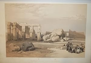
The Holy Land, Syria, Idumea, Arabia, Egypt & Nubia. With historical descriptions by George Croly and William Brockedon.
Edité par London, Moon, 1842 - 1849., 1842
Vendeur : Matthaeus Truppe Antiquariat, Graz, Autriche
Membre d'association : ILAB VDAO
Evaluation du vendeur :
Livre Edition originale
6 Bde. 3 Bll., 30 S., 21 Bll.; 23 Bll.; 2 S., 18 Bll.; 2 Bll., 8 S., 21 Bll.; 22 Bll.; 24 Bll. mit 120 Textabb. 3 Frontisp., 6 Titel, 1 Porträt, 118 Tafeln (alles in getönter bzw. farbig getönter Lithographie von Louis Hague), 2 Kupferkarten. Erste Ausgabe dieses epochalen Tafelwerks über den Nahen Osten mit allen 248 Ansichten des Heiligen Landes (in getönten Lithos) und Ägyptens (in farbig getönten Lithos). - Blackmer 1432. Lipperheide 1590 und 1591. Röhricht 1983. Abbey, Travel, 385 und 272. - "David Roberts was the first professional artist to visit the Near East without a patron or a connection to a military expedition or missionary group. He sailed to Alexandria in 1838 and for eleven months traveled up the Nile River, across deserts and mountains, through Egypt and the Holy Land, to arrive in Jerusalem on Easter 1839. He continued north to Lebanon and departed from Beirut in May. Roberts recorded his impressions of landscapes, temples, ruins, and people in three sketchbooks and more than 272 watercolors. These sketches and paintings provided the basis for the 247 lithographs published with text between 1842 and 1849 as the three-volume "Holy Land." The images were produced by Louis Haghe, the best and most prolific lithographer of the time. Originally from Tournai, Belgium, Haghe moved to England before 1825 and established himself as specialist of the hand-tinted lithograph. His sensitive handling of the lithographer`s tools imparts a range of tonality and color as well as a sense of the delicacy and spontaneous quality of Roberts`s original images. Roberts`s plates are among the most popular images of famous sites in the Near East. As John Ruskin wrote they make "true portraiture of scenes of historical and religious interest. They are faithful and laborious beyond any outlines from nature I have ever seen." (ww.metmuseum.org). - "In point of bulk and ambition Roberts`s Holy Land was one of the most important and elaborate ventures of nineteenth-century publishing, and it was the apotheosis of the tinted lithograph. There is pleasure to be had from many of the individual plates, where Haghe`s skilful and delicate lithography, and his faithful interpretation of Roberts`s draughtsmanship and dramatic sense, combine in what are undoubtedly remarkable examples of tinted lithographic work. Particularly in the Egypt and Nubia section, one feels that the colossal subjects and broad vistas were ideally suited to Roberts`s talent, trained as he was in theatrical scene-painting during his early days in Carlisle, Glasgow, Edinburgh, and London.Roberts was fully appreciative of Haghe`s work, writing that: `Haghe has not only surpassed himself, but all that has hitherto been done of a similar nature. He has rendered the views in a style clear, simple, and unlaboured, with a masterly vigour and boldness which none but a painter like him could have transferred to stone`" (Abbey 341). - Das Werk erschien in insgesamt 3 Varianten: Die kolorierte Subskribtions-Ausgabe (mit den 2 Bll. "Subskribenten-Verzeichnis"), eine Ausgabe mit farbigen getönten Lithographien und eine Ausgabe mit getönten Lithographien. Vorliegend ist eine Mischausgabe, die Ägypten Bände enthalten die farbig getönten Lithos, die Bände des heiligen Landes mit den getönten Lithos. - Titel mit hs. Namen. Teils etw. wasserrandig. Durchgehend fleckig, vereinzelt im weißen Rand stark fleckig. *** *** Copyright: Matthaeus TRUPPE Buchhandlung & Antiquariat - Stubenberggasse 7 - A-8010 Graz - ++43 (0)316 - 829552 *** *** Sprache: Deutsch Gewicht in Gramm: 0 Gr.-Fol. OHLdr. (restauriert, fleckig, Rücken mit ergänzten Fehlstellen).
-
Description de l'Égypte ou Recueil des observations et des recherches qui ont été faites en Egypte .
Edition originale
Couverture rigide. Etat : Trčs bon. Edition originale. 24 tomes de texte en 26 volumes in-8 et 11 volumes grand in-folio d'atlas (10 de planches et un atlas géographique).Demi-veau bleu glacé, dos lisses avec titres et tomaison en lettres dorées, plats recouverts de papier marbré bleu (reliure de Tessier relieur et doreur se S.A.R. le Duc d'Orléans, avec son étiquette au contreplat supérieur du volume Antiquités 1). (Dos des atlas refaits, plats conservés avec quelques restaurations de papier ; rares rousseurs légčres, frontispice restauré). SECONDE EDITION de ce monument de l'histoire du livre comprenant 994 planches.L'ouvrage comprend: Texte: Antiquités. Description - 5 volumes. Antiquités. Mémoires - 4 volumes illustrés de 13 tableaux, 5 planches et 1 carte. Etat Moderne - 8 tomes en 10 volumes illustrés de 45 planches (en 25 feuilles), 17 tableaux (en 17 feuilles) et 2 cartes (ancienne et comparée de l'Egypte, - de la Basse-Egypte). Histoire Naturelle - 6 volumes illustrés de 2 tableaux (en 4 feuilles) et 1 planche. Explication des planches - 1 volume Atlas: Antiquités - 5 volumes illustrés du frontispice, 420 planches (compris le portrait de Louis XVIII) et un tableau. Etat Moderne - 2 volumes illustrés de 189 planches sur 181 feuilles. Histoire Naturelle - 2 tomes en 3 volumes illustrés de 245 planches. Atlas géographique - 1 volume illustré de 53 cartes et planches dont titre gravé ŕ double page.Soit un total de 908 planches in-folio, auxquelles il faut rajouter l'illustration des volumes in8, soit 3 cartes, 32 tableaux et 51 planches.Trčs bel exemplaire. La Description de l'Egypte est le résultat de la collaboration des savants, artistes et techniciens qui suivirent Bonaparte en Egypte. C'est L'OUVRAGE LE PLUS MONUMENTAL JAMAIS CONSACRE A UN PEUPLE. Monge et Denou en furent les maîtres d'?uvre.Votée par le Directoire en avril 1798, l'expédition militaire en Egypte menée par Bonaparte se double d'une expédition scientifique.Pour cela, Bonaparte crée une commission des sciences et des arts composée de savants et experts ; au total, 167 personnes, toutes disciplines confondues, vont faire partie de l'expédition : physiciens, peintres, naturalistes, dessinateurs, mathématiciens, astronomes, géographes, architectes, sculpteurs, hommes de lettres, imprimeurs, etc. parmi lesquels Jacques Barraband, Geoffroy Saint Hilaire, Jules-César Savigny, Pierre-Joseph Redouté, Vivant Denon, Conté, Méchain, etc. Deux mois aprčs leur arrivée en Egypte, Bonaparte crée l'Institut d'Egypte dans le but de consigner, reproduire et répertorier les travaux et recherches des savants dans les domaines multiples et variés de l'antiquité, l'architecture, la langue, l'artisanat, la musique, l'industrie, la minéralogie, la médecine, etc. Malgré tous les obstacles, l'expédition réussit ŕ ramener une quantité de documents impressionnante et inédite. C'est grâce ŕ la compétence de tous ces hommes que cette ?uvre monumentale a pu voir le jour.Publiée tout d'abord en 1809, la Description de l'Egypte ou Recueil des observations et des recherches qui ont été faites en Egypte pendant l'expédition de l'armée française se divise en 4 grandes sections : l'Egypte Ancienne (antiquités), l'Egypte Moderne, l'Histoire Naturelle et la géographie.La seconde édition, dite de Panckoucke, de plus petit format, parut entre 1821 et 1829.La Description de l'Egypte ou Recueil des observations et des recherches qui ont été faites en Egypte pendant l'expédition de l'armée française CONSTITUE AUJOURD'HUI ENCORE UNE SOURCE DOCUMENTAIRE DE PREMIER ORDRE, nombre d'édifices représentés sur les planches ayant été complčtement détruits par la suite. Atabey, 343 (1st edition) ; Brunet, II, 617. // ENGLISH // 24 volumes of text in 26 volumes in-8 and 11 volumes large in-folio of atlases (10 of plates and a geographical atlas).Half blue glazed calf, smooth spines with titles and tomaison in gilt letters, boards covered with blue marbled paper (binding by Tessier, binder and gilder to H.R.H. the Duke of Orleans, with his label on the upper fro.
-
Atlas Universel De Geographie Physique, Politique, Statistique et Mineralogique Sur L'echelle De 1/1641836 Ou D'une Ligne Par 1900 Toises
Edité par Brussels: [P.M.G. Vandermaelen,] 1827., 1827
Vendeur : Arader Galleries - AraderNYC, New York, NY, Etats-Unis
Evaluation du vendeur :
Livre Edition originale
Hardcover. Etat : Good. 1st Edition. 6 volumes. Folio (21 1/8 x 14 inches). 7 lithographed index maps, one chart of comparative altitudes of mountains, and 382 double-page lithographed maps by Henri Ode and Vandermaelen, hand-colored in outline (lower outer blank corners of first 3 leaves in volume I renewed without loss, some foxing on title-pages, to text leaves, to the general map of North America, and to Asia no. 8 (part of Russia). Contemporary green straight-grain morocco, gold-tooled border and corners (quite worn, backstrips detached or torn, edges and covers scuffed). Provenance: from the library of the Onondaga Historical Association, with their bookplate and library stamps on the end-leaves. THE FIRST LITHOGRAPHED ATLAS First edition. Vandermaelen, a renowned Belgian cartographer, who is known for his many detailed maps of Brussels, built one example of the monumental globe that the maps in these volumes were designed to create. It required the building of a custom-made room, within Vandermaelen's own spacious Geographical Institute, and measured more than 23 feet in diameter. As such it remains the largest image of the earth's surface available to a 19th century audience. As a result of its large size, and uniform scale this atlas is very important for its large scale depiction of newly discovered and developed areas, including the American West, the Far East and Australia. Koeman I Vdm 1; NMM III 179; Philips, Atlases 747; Tooley 311.
-
[MANUSCRIT] Cartes particuličres par gouvernements de la province de Dauphiné
Edité par c1630-1640, 1630
Etat : Trčs bon. Oblong de 37 x 26,5 cm, vélin souple ŕ recouvrement de l'époque, dos lisse avec inscription manuscrite «Dauphiné», double encadrement des plats de simples et doubles filets dorés, fer ovale ornementé de motifs floraux poussé au centre des plats, tranches dorées.2 ff. nch, 45 cartes manuscrites:1. Carte Generalle de dauphine2. Gouvernem' de Cisteron3. Plan de Cisteron4. Gouvernemen de la Principauté dorange5. Plan de la Ville & Citadelle dorange6. Gouvern' d'avignon7. Gouverneme' du St Esprit8. Plan de la Ville & Citadelle du Pont St Esprit9. Gouvern' de Turin10. Plan de la Ville & Citadelle de Turin11. Gouvernem' de Casal & de Trin12. Plan de Cazal13. Plan de la Ville & Citadelle de Trin14. Gouverne' de Milan15. Plan de la Citadelle de Milan16. Gouvernement d'embrun17. Plan d'ambrun18. Gouvernement de Puimore19. Plan de Puimore20. Gouvernem' du Pas de Lescluze21. Plan du Pas de Lescluze22. Gouvern' de Montlimar23. Plan de Montlimar24. Gouverneme' de Pignerol & de Briqueiras & la Perouze fort stebregide25. Plan de Pignerol26. Plan du fort Saincte Bregide27. Plan du Fort de la Perouze28. Plan de la Ville & chau' [château] de Briqueiras29. Gouvern' de Valance30. Plan de Valance31. Gouverne' du Chasteau dčxille & Gelasse32. Carte Particulliere des Environs de Suze33. Plan du Chasteau dexille34. Plan du fort de Gelasse35. Gouvern' de Grenoble36. Plan de la Ville & Citadelle de Grenoble37. Gouvernement du Fort de Baraus & Montmelian 38. Plan du Fort de Barrault39. Plan de la Ville & Citadelle de Montmelian40. Gouverne' de Quirieu41. Plan de Quirieu42. Gouverneme' de Bourg en Bresse43. Plan de la Ville & Citadelle de Bourg en Bresse44. Gouvern' de Genesue [Genčve]45. Plan de la Ville & Citadelle de Genesue [Genčve]La cartographie du territoire français a été un enjeu primordial ŕ l'époque moderne comme en témoigne le géographe Nicolas de Nicollay pour qui elle devait permettre au souverain «sans grande peine de voir ŕ l'?il et toucher du doigt»[1] le royaume dans toute son étendue et sa diversité. Carrefour des Alpes et de l'Europe méridionale, la province du Dauphiné, conquise aprčs de hautes luttes par les français, est un territoire stratégique dont la géographie montagneuse est un défi non seulement pour la cartographie, la politique mais aussi la pratique des arts de la guerre. Cet atlas manuscrit militaire, d'une trčs grande rareté, cartographie cette zone dans son entičreté et représente aussi son voisinage proche de la confédération des treize cantons en passant par les Duchés de Savoie et du Milanais. Outre son intéręt géographique et administratif, la vocation guerričre de ce livre est clairement évoquée en introduction de son Explication pour l'intelligence des cartes. L'auteur précise qu'il a ajouté les «chemins par oů l'armée, et le canon, peuvent passer pour aller en Italie». De fait, cet ouvrage témoigne des fortes ambitions françaises dans cette région au début du XVIIe sičcle ainsi que d'une volonté clairement expansionniste. L'intéręt marqué de son auteur pour les environs de Suze permet de supposer que la réalisation du manuscrit est postérieure ŕ la bataille du 6 mars 1629 oů s'imposčrent les troupes françaises de Louis XIII. Visiblement peu concerné par la représentation de la déclivité de cette région, le cartographe ayant réalisé cet ensemble s'est surtout s'intéressé aux frontičres, aux voies de communication et ŕ la toponymie alpestre.Au regard du savoir et des informations dispensées dans l'ensemble de ce manuscrit, Christophe Tassin semble ętre une des rares personnes ŕ avoir pu accéder ŕ une telle masse de connaissances dont la carte secrčte réalisée par Jean de Beins en 1617[2]. Nous proposons donc de lui attribuer cet atlas. Ingénieur et géographe du roi, ce cartographe «est surtout célčbre pour ses petits atlas oblongs», il entretient aussi des «rapports étroits avec le milieu des éditeurs de carte» selon Mireille Pastoureau[3]. Son ?uvre gravé a été édité par cinq libraire: Melchior Tavernier, Jean Mes.
-
De triangulis planis et sphaericis. (.) quae extructa est ŕ Ptolemeaeo & Copernico de Revolutionibus orbium caelestium. [Avec : ] - Problematum astronomicorum et geometricorum sectiones septem. [Avec :] - In Ptolemaei magnam compositionem, quam almagestum vocant, libri tredecim
Edité par (Heinrich Petri & Peter Perna), Basel, 1561
Vendeur : Hugues de Latude, Villefranche de Lauragais, France
Membre d'association : ILAB
Evaluation du vendeur :
Edition originale
*** Premičre édition donnée par Daniel Santbech de cet ouvrage de Regiomontanus. Il l'a revu et commenté ŕ la lumičre des découvertes de Copernic. Rédigé en 1464, ce texte n'a été publié pour la premičre fois qu'en 1533 ŕ Nuremberg. Illustré de trčs nombreux bois gravés dans le texte. Relié ŕ la suite : - SANTBECH. Problematum astronomicorum et geometricorum sectiones septem. Basileae, Per Henrichum Petri, et Petrum Pernam, 1561. In-folio de (20), 294, (2) pp. Premičre édition. Une suite de l'ouvrage précédent, qui traite des applications pratiques. La plus grande partie est consacrée ŕ l'astronomie et ses instruments. L'auteur traite aussi des cadrans solaires, de géographie, de navigation, d'arpentage, de balistique. Le mathématicien et astronome Daniel Santbech était hollandais. En 1651, Riccioli a donné son nom ŕ un cratére de la Lune. Relié avec : - REGIOMONTANUS, PEURBACH. In Ptolemaei magnam compositionem, quam almagestum vocant, libri tredecim. Conscripti ŕ Joanne Regiomontano . ; in quibus vniversa doctrina de coelestibus motibus, magnitudinibus, eclipsibus &c., in epitomen redacta, proponitur. Nuremberg, J. Berg, U. Neuber, 1550. In-folio de (116) ff. Troisičme édition de la premičre traduction complčte, donnée par Peurbach et Regiomontanus ŕ partir d'un manuscrit grec découvert ŕ Byzance. (La premičre Venise, 1496, la 2e Bâle, 1543). Titre en noir et rouge et nombreux bois gravés dans les marges. Exemplaire dans une magnifique reliure en maroquin aux armes et au chiffre de JACQUES-AUGUSTE DE THOU. Ce volume porte ses seules armes et a donc été relié avant 1587, date de son premier mariage. Jacques-Auguste de Thou (1553-1617) commença sa collection vers 1573. Ce fameux bibliophile a rassemblé des milliers de livres sur tous les sujets, mais, il est cependant rare de rencontrer un livre de science portant ses armes. Celui-ci a été particuličrement bien relié, dans un maroquin précieux, probablement de Turquie. *** In-folio de (8), 146, (38) pp. Maroquin citron, dos ŕ nerfs orné du chiffre de Thou, plats aux armes du męme, encadrements dorés, (Reliure de l'époque.) - - - - - - - - - - - - - - - - - - - - - - - - - - - - - - - - - - - - - - - - - - - - - - - - - - - - - - - - - - - - - - - - - - - - * Copy from the famous library of Jacques Auguste de Thou, in a splendid morroco binding. First edition given by Daniel Santbech. He revised and augmented this work by Regiomontanus, according to Copernicus' discoveries. Written in 1464, it was published for the first time in 1533 in Nuremberg. "The first systematic treatise on plane and spheric trigonometry to be published in Europe. (.) With 'De triangulis' trigonometry was established as an independent discipline. Regiomontanus' original purpose, however, had been to furnish astronomers with a mathematical technique essential for their studies, and in this De triangulis had a success perhaps greater than its author could have dreamed of. For in 1539 Georg Joachim Rheticus presented a copy of the work's 1533 edition as a gift to Copernicus. The great astronomer had already written the trigonometrically-based portion of his De Revolutionibus without knowledge of his predecessor's treatise. After reading the new book, Copernicus modified the presentation of several of his own indispensable theorems by inserting two leaves in the manuscript of the De Revolutionibus. Hence, Rheticus' remark that Regiomontanus began the reconstruction of astronomy that Copernicus completed takes on a fuller meaning." (Rose, The Italian Renaissance of Mathematics). Bound with: - SANTBECH. Problematum astronomicorum and geometricorum sectiones septem . Basileae, Per Henrichum Petri, and Petrum Pernam, 1561. First edition. A continuation with practical applications of the previous work. Most of the book is devoted to astronomy and its instruments. The author also deals with sundials, geography, navigation, surveying, ballistics . Daniel Santbech (fl. 1561) was a Dutch mathematician and astronomer. In 1651, Riccioli gave his name to a crater on the Moon. Both volumes are illustrated with many woodcuts in text. Bound with: - REGIOMONTANUS, PEURBACH. In Ptolemaei magnam compositionem, quam almagestum vocant, libri tredecim. Nuremberg, Apud Ioannem Montanum & Ulricum Neuberum, 1550. Third edition of the first complete translation of Ptolemy, given by Peurbach and Regiomontanus from a Greek manuscript discovered in Byzantium. (The first Venice, 1496, the 2nd Basel, 1543). Title in black and red and many wood cuts in the margins. Contemporary yellow morroco, spine gilt with nerves, arms of de Thou gilt on boards. Splendid copy with a distinguished provenance. - -.
-
Voyage au Pole Sud et dans l'Océanie sur les corvettes l'Astrolabe et la Zélée, exécuté par ordre du roi pendant les années 1837, 1838, 1839, 1840. 22 (of 23) text-volumes (in 19) and 6 atlas-volumes (in 4) in 23 volumes.
Edité par Paris, Gide et Baudry, 1841-1855., 1855
Vendeur : Manfred Nosbuesch, Kuchenheim, Allemagne
Membre d'association : ILAB VDA
Evaluation du vendeur :

Large 8vo, Large Folio and Imp.-Folio. Text-volumes with 3 plates. Atlas-volumes with 2 frontispieces and 530 (of 533) lithogr. and engr. plates, maps and plans. Contemp. half calf, gilt. Sabin 21216; Nissen ZBI 1200. - Text-volumes: Dumont d'Urville. Histoire du voyage. 10 vols. 1841-1846; Vincendon-Dumoulin et Coupvent-Desbois. Physique. 1842; Vincendon-Dumoulin. Hydrographie. 2 vols. in 1. 1843-1851. 2 plates; Botanique. 2 vols. in 1. Vol. 1: Montagne, M. C. Plantes cellulaires. Vol. 2: Decaisne, J. Description des plantes vasculaires. 1845-1853; Hombron et Jacquinot. Zoologie. Vols. 1-4 (of 5). 1846-1853; Grange, M. J. Géologie, minéralogie et géographie physique du voyage. 2 parts in 1 vol. 1848. 1 plate.; Dumoutier. Anthropologie. 1854. - Atlas Pittoresque: 2 frontispieces, 198 plates and 9 maps. - Atlas Hydrographique: 57 maps. - Atlas Zoologique: 137 (of 140) plates. - Atlas Anthropologie: 50 plates. - Atlas Géologie, Minéralogie: 9 plates and 4 maps. - Atlas Botanique: 66 plates. - Atlas Zoologique lacking 3 plates: Mammifčres, plate 20b: Dugong des Indes, details; Oiseaux, plate 12: Colombe de Félicie; Reptiles, plate 2: Proctotrčte mosaique. - 2 plates loosely inserted: Poissons, plate 4: Centropiste tasmanien and Crustacés, plate 7: Lithode antarctique. - Some occasional browning or staining. A very nice set, uniformely and decoratively bound.
-
[Image du monde. Nouvellement imprimée a Paris par Alain Lotrian]. Sensuyt lymaige du monde contenant en soy tout le Monde mis en III parties, cestassavoir , Asie, Affrique et Europe. Avec les pays, provinces et citez et les merveilleuses et diverses creatures qui sont dedans.
Edité par Paris, [Lotrian], [circa 1520-1530. 1530, 1530
Vendeur : JF LETENNEUR LIVRES RARES, Saint Briac sur mer, France
Membre d'association : ILAB
Evaluation du vendeur :

Signé
1 vol. in-8° (187 x 140 mm) de: [26] ff. (dont titre gravé et 1 blason gravé sur le dernier f.). Plein maroquin rouge XIXe, dos ŕ faux nerfs orné et titré ŕ l'or, encadrements de frises dorées sur les plats avec le navire de Christophe Colomb dans chaque angle, encadrement intérieur, emboitage moderne en demi maroquin rouge et toile (Reliure signée par Chambolle-Duru pour le Baron Pichon). (étiquette "288" de la bibliothčque de Charles Fairfax Murray; ex-libris ŕ l'or sur maroquin rouge du Baron Pichon avec sa devise "MEMOR FVI DIERVM ANTIQVORV PS. CXLII."; inscription en page de garde ŕ l'encre "exemplaire de Fernand Colomb mort en 1539, fils de Christophe Colomb. Acheté en 1885. hez. Edition non citée.") Exceptionnel exemplaire de la célébre "Colombina Biblioteca" de cet ouvrage géographique populaire constitué d un recueil médiéval de géographie, d'astronomie et d'autres sciences physiques, texte qui a circulé sous forme de vers et de prose depuis le 13čme sičcle. Il est attribué ŕ Gautier de Metz, počte et prętre français qui l aurai produit (vers 1246), se basant sur le texte latin médiéval « Imago mundi » d'Honorius Inclusus. Le počme de Gautier est l'un des nombreux ouvrages médiévaux «encyclopédiques» qui décrivent la création, la géographie et l'astronomie avec des passages factuels et imaginaires. Des monstres, des trésors et des terres lointaines sont évoqués dans ce počme pseudo-scientifique, qui a été traduit en plusieurs langues au moyen âge et magnifiquement illustré dans de nombreux manuscrits. Le počme "Mappemonde", attribué ŕ Gautier de Metz, fut probablement transformé en prose par Maistre Gossouin en 1265. La présente édition reproduit celle de 1485 due Cailant, mais avec quelques ajouts ŕ la fin. Un exemplaire similaire est présent dans les collections de la NY public library. Ferdinand Columbus (1488-1539), fils du découvreur du Nouveau Monde, accompagna son pčre lors de son quatričme voyage en Amérique entre 1502-1504. Aprčs sa mort, Il rentra en Espagne, puis voyagea dans toute l'Europe et constitua une bibliothčque de plus de 15 000 livres. Il semble avoir eu un intéręt particulier pour les éditions de l'Image du Monde. Ce livre et d'autres tels que l'Imago Mundi de Pierre d'Ailly ont inspiré les premiers plans de découverte de son pčre. La bibliothčque de Ferdinand fut confiée ŕ la bibliothčque de la cathédrale Saint-Paul de Séville. Pendant les XVIe et XVIIe sičcles la bibliothčque, comme d'autres bibliothčques de la Renaissance, elle fut négligée. Ainsi, Lorsque la bibliothčque fut inventoriée en 1684, son contenu avait diminué ŕ 5000 volumes. Les livres de la bibliothčque de Ferdinand Columbus sont extręmement rares sur le marché. D aprčs nos recherches, aucun autre volume de la « Colombina Biblioteca » n est passé en salle des ventes ces cinquante derničres années. Provenance: de la bibliothčque de Ferdinand Columbus (ex-libris, "Colombina Biblioteca"), puis du baron Pichon ("acheté en 1885") avec son ex-libris de cuir rouge au dos du premier plat, puis de Charles Fairfax Murray (avec l'étagčre "288" au verso du premier plat). Selon Murray, c'est le seul exemplaire connu de cet ouvrage de cosmographie. 1 vol. in-8° (187 x 140 mm) of: [26] following. (including engraved title and 1 coat of arms engraved on the last f.). Full 19th century red morocco, spine with false raised bands decorated and titled in gold, frames of gilded friezes on the covers with Christopher Columbus' ship in each corner, interior frame, modern casing in half red morocco and canvas (Binding signed by Chambolle -Duru for Baron Pichon). (label "288" from the library of Charles Fairfax Murray; gold bookplate on red morocco by Baron Pichon with his motto "MEMOR FVI DIERVM ANTIQVORV PS. CXLII."; inscription on the flyleaf in ink " copy of Fernand Colomb died in 1539, son of Christopher Columbus. Purchased in 1885. hez. Edition not cited.") Exceptional copy from the famous« Colombina Biblioteca » of this scarce popular geographical work consisting of a medieval collection of geography, astronomy and other physical sciences, a text that has circulated in the form of verse and prose since the 13th century. The work is attributed to Gautier de Metz, French poet and priest who produced it around 1246, based on the Medieval Latin text "Imago mundi" by Honorius Inclusus. Gautier's poem is one of the many "encyclopedic" medieval works that describe creation, geography and astronomy with factual and imaginary passages. Monsters, treasures and distant lands are evoked in this pseudo-scientific poem, which has been translated into several languages during the Middle Ages, and beautifully illustrated in numerous manuscripts. The poem "Mappemonde", attributed to Gautier de Metz, was probably transformed into prose by Maistre Gossouin in 1265. This edition reproduces that of 1485 due Cailant, but with some additions at the end. A similar copy is present in the collections of the NY public library. Provenance: from the library of Ferdinand Columbus (ex-libris, "Colombina Biblioteca"), then from Baron Pichon ("bought in 1885") with his ex-libris in red leather on the front, then Charles Fairfax Murray (with shelf "288" on the back of the cover). According to Murray, this is the only known copy of this edition. Ferdinand Columbus (1488-1539), son of the discoverer of the New World, accompanied his father during his fourth voyage to America between 1502-1504. After his death, he returned to Spain, then traveled all over Europe and set up a library of more than 15,000 books. He seems to have had a particular interest for the editions of the "Image du Monde". This book, and others such as Imago Mundi by Pierre d'Ailly, inspired his father's first discovery plans. Ferdinand's library was entrusted to the library of St. Paul's Cathedral in Seville. During the 16th and 17th centuries the library, like other Renaissance libraries, was neglected. Thus, when the library was inventoried in 1684, its contents had decre.
-
Cartes Marines
Edité par Paris: N. Bellin, 1737-1754, 1754
Vendeur : Arader Galleries - AraderNYC, New York, NY, Etats-Unis
Evaluation du vendeur :
Folio (26 x 19 5/8 inches). The title-page and etched cartouche with the imprint of Chez Huquier, rue St. Jacques, of Paris, and initialled in the image "C.P.R." surrounding a calligraphic manuscript index ("possibly in Bellin's hand" - Sotheby's) laid down. 23 EXCEPTIONALLY FINE double-page engraved maps, the rhumb lines of one printed in olive green ink, of another two printed in sanguin, 2 full-page maps, for a total of 25 (of 29, lacking four maps) by Bourgoin le Jeune, Dheulland and others, all with original hand-colour in outline. A magnificent fine French binding of full contemporary red morocco, each cover decorated with elegant gilt borders and with the gilt arms of Jean Baptiste de Machault d'Arnouville, gilt inner dentelles, and the spine richly gilt in 8 compartments with 7 raised bands, with an olive green lettering-piece in one, all edges gilt. Provenance: with the gilt supra-libros of Jean Baptiste de Machault d'Arnouville (1701-1794); Christopher Henry Beaumont Pease, Lord Wardington (1924-2005), his sale, Sotheby's 18th October, 2005, lot 38. "This is probably one of the earliest collections of charts formed by Bellin after he had taken over the Marine Office and reprinted the Neptune François in 1753. The plates are by order of Monseigneur Le Comte de Maurepas, and his successor M. Rouillé, Chevalier Comte de Jouy, who in turn was succeeded by M. de Machault, around 1754, for whom this copy was bound" (Wardington Catalogue). Of the twenty-nine charts listed in the manuscript index it is doubtful whether six were ever present. These are numbers 5, 9, 14, 19, 22 and 23. Two maps have been added from other copies to replace maps 5 and 22 ("Carte reduite de l'Isle de la Jamaique" and "Carte reduite de l'ocean meridionale"). Maps that are relevant to America include the world map, a map of the North Sea showing the coast of Labrador, 2 maps of the Atlantic, the Pacific ocean, a map of the Gulf of Mexico, another of the the gulf of the St. Lawrence River, and 2 maps of the West Indies. There is also a fine map of the Philippines. Jacques Nicolas Bellin (1702-1772), the most significant and influential chart publisher in eighteenth-century France, was appointed chief cartographer and hydrographer to the French Navy in 1721. He was appointed "ingénier hydrographe" to the French navy's Dépôt des cartes et plans de la Marine in August 1741. Bellin was also a member of the Académie de Marine and of the Royal Society of London. During his 50-year career, Bellin published a number of atlases, including 'Hydrographie française' (1753), 'Carte de l'Amerique septentrionale' (1755), 'Petit Atlas Maritime' (1764), and 'Nouvelle méthode pour apprendre la géographie' (1769). His maps of the French territories in North America are considered particularly successful and valuable. Machault was nominated Controller of Finances in 1745, and introduced the "Tax de vingtieme", a levy of 5% on all income; it proved unpopular and he lost the support of Louis XV and Madame de Pompadour. In 1754 went on to become Minister of Marine, but in 1757 he was disgraced and retired to the country. From the distinguished library of Lord Wardington whose collection of Atlases was unique: "a panoply of the history of cartography and of great mapmakers" (Andrew Phillips "An Appreciation", Sotheby's sale catalogue). An attractive copy. Sabin 9141. Catalogued by Kate Hunter.
-
Expédition dans les parties centrales de l'Amérique du Sud, de Rio de Janeiro a Lima, et de Lima au Para; exécutée par ordre du gouvernement Français pendant les années 1843 a 1847. Paris, P. Bertrand, 1850-1859
Edité par P. Duménil, Paris, 1840
Livre Edition originale
Hardcover. Etat : Very Good. First Edition. 7 parts in 13 volumes. 8vo (6 vols.), 4to (6 vols.), folio 1 Vol. With 441 lithographed and tinted lithographed plates and maps, including 401 partly or completely hand-coloured. Original red 3/4 morocco. The most important scientific expedition to South America in the 19th century, led by the French naturalist Francis de Castelnau (1810-1880) First part Histoire du Voyage 8vo, 6Vol. (7), 467pp., 485pp, 483pp, 467pp, 480pp, 432pp folding map. Second part Vues et scenes : 4to, 14pp 59 of 60 engraved plates (lacks #58) Third part Antiquites des Incas : 4to, (4), 7pp, 60 of 62 engraved plates (lacks #19 and #29) Fourth part Itineraires e coupes geologiques :Folio, 8pp, 76 maps, plans and views, partly or completely hand-coloured, Fifth part Geographie des parties centrales : Folio, 10pp, (1), 29 of 30 double page maps (lacks #12) outlined in color and partly hand-coloured Sixth part Botanique : 4to, (1), 90 engraved plates (lacks text and vol 2 of text) Seventh part Vol 1 : Zoologie Animaux, nouveaux ou rares : 4to. Anatomie (8), 100pp, 18 engraved plates (1 hand colored), Mammifčres (2), 116pp 13/20 engins plates (lacks #1 to #7), Oiseaux (2), 98pp, (1), 8/20 engraved plates (lacks #1 to 12). Seventh part Vol 2 Poissons (13), 113pp, 50 engraved plates, Reptiles (1), 95pp, 18 engraved plates. Seventh part Vol 3 Entomologie : 204pp, 20 engraved plates François de Castelnau (December 25, 1810 - February 4, 1880) was a French naturalist, born in London (some sources give his year of birth in 1812). Also known as François Laporte or Francis de Castelnau. Born in London, illegitimate son of the Countess of Mesnard-La Barotičre, daughter of the Duke de La Force, widow after several years. He studied natural history in Paris. From 1837 to 1841 he made a scientific expedition to Canada where he studied the fauna of the Canadian lakes and the political systems of Canada and the United States. From 1843 to 1847, with two botanists and a taxidermist, he crossed South America from Peru to Brazil, following the Amazon River and the La Plata river systems, the scientific results of this expedition are of considerable importance. Besides the zoological, botanical, mineralogical and ethnographical collections he brought to Europe, Castelnau provided a wealth of information with the astronomical, barometrical, hydrographical and hydraulic observations and determinations he made. The beautifully coloured plates make it a desired work for bibliophiles as well. During their travels Castelnau and his men gathered an enormous amount of information through meteorological, magnetic, botanical and zoological observations. He served as a French consul in Bahia in 1848; in Siam from 1848 to 1862, and in Melbourne, Australia from 1864 to 1877, where he died in 1880. Borba de Moraes, pp. 167-168; Howgego, 1800-1850, C14; Nissen, ZBI 88-89; Sabin 11411.
-
Grosser Atlas über d.gantze Welt, Atlas Homann, 1720, 176 maps,
Edité par Homann J.B.,1664-1724, 1724
Vendeur : Hammelburger Antiquariat, Hammelburg, Allemagne
Evaluation du vendeur :
Hardcover. Etat : Gut. Homann, Joh. Bapt.: "Grosser Atlas Uber die Gantze Welt wie diese sowol nach Göttlicher Allweisen Schöpfung aus den heutigen Grund Sätzen der berümtesten Astronomorum Nicolai Copernici und Tychonis de Brahe, in der Bewesgung und unermeßlichen Weite des Himmels als auch in dem Umfang unserer mit Wasser umgebenen allgemeinen Erd Kugel zu betrachten Samt einer kurtzen Einleitung zur Geographie worinnen die Erde 1. Mathematice: Nemlich was sie mit der himmlischen Sphaera für eine Correspondenz habe. 2. Physice: Wie sie in ihren natürlichen Stücken durch Wasser und Land unterschieden. 3. Historice: Wie sie in ihre darauf befindliche Monarchien, Königreichen/Staaten und Herrschafften auch nach Ausbreitung verschiedener Religionen eingetheilet/deutlich beschrieben durch Herrn Johann Gabriel Doppelmayr/der kays. Leopoldinisch und Carolinischen Academiae Natur. Curio. wie auch der Königl. Preussischen Siocietät der Wissenschaften Mitglied und Math. PP. Ordin, allhier/und mit mehr als hundert auserlesenen theils Astronomischen/meistentheils aber Geographischen Charten in welchen alle bißher zu Wasser und Land geschehene Land Entdeckungen aus denen berühmtesten Autoribus dieses Seculi anbemercket worden in Kupffer gebracht und angefertiget von IOHANN BAPTIST HOMANN, Der Röm. Kays. Majestät Geographo, und Mit Glied der Königl. Preussischen Societät der Wissenschaften. Nürnberg in Verlegung des Auctoris. Gedruckt bei Johann Ernst Adelbulner M D CC XVI." BESCHREIBUNG: (um 1720). Gr.-Fol. 52X35X10 CM:; Gest. Portr. Kaiser Karls VI. v. Jac. Weißhoff (dat. 1717), kolor. Kupfertit. "Atlas novus terrarum orbis imperia, regna et status exactis tabulis geographice demonstrans, opera iohannis baptistae homanni sacrae caes. maj. geographi, e reg boruss societ scient membri noribergae." v. Caspar Luyken, typogr. Tit. in Rot u. Schwarz mit gest. Kärtchen der nördl. Hemisphäre als Titelvign., 2 Bll. Widm. an Karl VI. mit gest. Kopfvign., 1 Bl. Reg. (verz. 179 Positionen incl. Titelei), 42 SS. (Einltg. zur Geographie v. Joh. Gabr. Doppelmayr), 176 dpblgr. kolor. Kupferktn. u. -taf. Ldr. um 1800 unter Verwendung älterer blindgepr. Deckelbez., Rsch. Referenz:C. Sandler, Johann Baptista Homann, die Homännischen Erben, Matthäus Seutter und ihre Landkarten. Kat. d. Homann-Ausst. Nbg. 2002, Nr. 104 u. Abb. 71. Imago Mundi, vol. 49. - Stark erweiterte Fassung des erstmals 1716 mit nur 117 Ktn. herausgegebenen "Grossen Atlas", wohl um 1720 erschienen. Inhalt: Himmelsglobus/Armillarsphäre/Erdglobus; 8 Himmelsktn.; 6 Darstellungen des Sonnensystems; Mondkarte; Weltkarte; Europa (2); Asien; Afrika; Amerika; Mississippi; Nova Anglia; Virginia; Mittelamerika; Britische Inseln (4); Iberische Halbinsel (3 inkl. Portugal mit Nebenkarte Brasilien); Frankreich (8); Italien (10 inkl. Plan v. Rom); Belagerung v. Korfu (2); Deutschland (56); Schweiz; Österreich (10); Böhmen u. Mähren (10); Schlesien; Benelux (7); Griechenland (3); Ägypten; Ungarn (3); Donau (3); Skandinavien (12 inkl. Belagerung v. Friedrichshall 1718); Polen; Livland u. Curland; Ukraine; Russland (3 inkl. Plan v. St. Petersburg); Kaspisches Meer; Osmanisches Reich (2); Palästina; Sturmflut v. 1717; Kriegsschiff; Flaggen; Kriegskunst; zweite Weltkte. ("Basis geographiae recentioris astronomica"); Chronometer zur Längenbestimmung. - Einige Ktn. mit gr. Stadtansichten im unteren Teil, darunter Belgrad, Bremen, Danzig, Erfurt, Erlangen, Frankfurt am Main, Genua, Hamburg, Hildburghausen, Klagenfurt, Konstantinopel, Kopenhagen, Nürnberg, Stockholm, Stralsund, Wien u. Wismar. Taf. 83 (Prospectus Norimbergenses), 89 (Prospectus Salisburgenses) u. 101 (Prospectus partium Viridarii) aus einem anderen Atlas von Homann. - Die in schönem Verlagskolorit vorliegenden Ktn. u. Taf., im Register num. 4-179, sind rückseitig v. alter Hand ebenfalls num., allerdings ist ab 141 die Numerierung durch Einfügung einer im Reg. nicht aufgelisteten zusätzl. kolor. Ägypten-Kte. verschoben. Karte 21 (Europa) u. 44 (Italien) links b---.
-
Voyage de découvertes aux terres Australes. Exécuté par ordre de sa Majesté l'Empereur et Roi, Sur les Corvettes le Géographe, la Naturaliste, et la Goelette le Casuarina, Pendant les Anées 1800, 1801, 1802, 1803 et 1804. [Historique] Rédigé en parti. - [THE FIRST PUBLISHED COMPLETE AND FULLY DETAILED MAPPING OF AUSTRALIA]
Vendeur : Lynge & Sřn ILAB-ABF, Copenhagen, Danemark
Membre d'association : ILAB
Evaluation du vendeur :
Paris, 1807-1816 (Historique) & 1815 + 1812 (Navigation & Geographie). 4to & folio. Three text-volumes in 4to and three atlas, two in small folios, one (Navigation & Géographie) in elephant folio. All bound in nice contemporary brown half calfs with gilt spines. The first four (i.e. Historique-section) are uniform. The Navigation & Géographie-part with some brownspotting, the text-voume has been re-enforced at front hinge and corners and extremities are worn. There's a repaired tear to one of the maps. The Historique-section is generally very nice, clean, and fresh. Vil. I of the atlas has a torn lower back hinge, but no loss. A very nice set in strictly contemporaru bindings, with the tissue-guards, and FULLY COMPLETE WITH ALL 40 ETHNOLOGICAL AND ZOOLOGICAL PLATES, MOSTLY COLOURED, ALL 46 MAPS, BOTH TABLES, AND THE FRONTISPIECE PORTRAIT. Historique: Text: XXXI, (1), 471 pp. + engraved frontispiece-portrait + two folded tables (4), XV, (1), 496, (2, -errata), III (contents) pp. Atlas: (vol. I, plates:) (6) pp. + 40 plates (numbered 2-41 NB. plate I of the the map-volume constitutes also nr. I of the plate-volume - as always (see also Ferguson) )" (vol. II, maps:) 6 pp. + 14 maps, two of which are folded.Navigation & Géographie: Text: XVI, 576, (2, -errata) pp. Atlas: (2) ff. + 32 maps, 25 of which are double-page, 7 single. Rare fully complete copy, with both the History- and Navigation&Geography- parts of one the most important and famous descriptions of Australia ever published. One of the maps included constitutes the first published map to show the entire South Australian coastline.In April 1802, the British navigator Matthew Flinders and his French counterpart Nicolas Baudin met at Encounter Bay. Both men had been sent out by their respective governments to chart and explore the unknown southern coast of Australia. Between them, Flinders and Baudin explored, mapped and named most of the 3,700 kilometres from Ceduna on the west coast to Robe in the southeast, known in 1802 as "the unknown coast". Although Flinders in fact beat Baudin to "the unknown coast", the famous French account was published first and thus constitutes not only the first full description of the continent of Australia, but also contains the first published complete and fully detailed map of Australia. "In October 1800, Nicolas Baudin commanded an expedition to the south seas to complete the French survey of the Australian coastline, and make scientific observations. The two ships, "Le Geographe and Le Naturaliste", arrived near Cape Leeuwin in May 1801. Following instructions issued in France, both ships sailed north along the western coast of the continent. After staying at Timor, the French then sailed south to survey Van Diemen's Land [Tasmania]. In following this itinerary, they missed the opportunity to be the first Europeans to survey the unknown southern coast. By early April 1802 Baudin in "Le Geographe" was in South Australian waters. He sailed westwards along the southern coastline, meeting Flinders at Encounter Bay, and continuing to Golfe de la Mauvaise [Gulf St Vincent] and Golfe de la Melomanie [Spencer Gulf], giving French names to many locations already named by Flinders. At Cape Adieu the survey was abandoned and Baudin sailed for Port Jackson where "Le Naturaliste" had already arrived. After wintering at Port Jackson, Baudin returned to the southern coast for a more detailed survey, and in January 1803 circumnavigated Ile Borda [Kangaroo Island]. While Baudin anchored at Nepean Bay, Freycinet and the geographer Boullanger explored the two gulfs in "Casuarina" - "Le Naturaliste" had been sent back to France with its scientific collections. By the end of February "Le Geographe" and "Casuarina" rendezvoused at King George Sound, and then explored the west and northwest coasts of 'New Holland', before heading home via Timor. Baudin died in 1803 on the homeward voyage, so publication of the account and charts of his voyage was undertaken by Francois Peron, the expedition's naturalist. The first volume of "Voyage de decouvertes aux Terres Australes" and Volume I of "Atlas", which included plates, was released in 1807. French place names were recorded for 'Terre Napoleon' west of Wilson's Promontory. As Peron died in 1810, cartographer Louis de Freycinet continued to edit the voyage's account, and in 1811 he published the second part of "Atlas", which featured the charts of the expedition, again recording French place names on 'Terre Napoleon.' The French expedition's charts were published in 1811 - three years before Flinders'. Freycinet's "Carte General de la Nouvelle Hollande" was therefore the first chart of Australia, bringing together the results of English and French surveys. The French charts are generally acknowledged as beautiful with their elaborate title cartouches with flora and fauna.In the end, claims of 'primacy' - or who was where first - were what mattered most to the authorities and to Flinders. With the French charts published first, with French names along the length of the South Australian coast, they laid a claim to that portion of the continent and called it "Terre Napoleon". When Flinders' charts were finally published in July 1814, he was scrupulous in honouring prior discoveries on the coast - hence 'Discovered by Nuyts 1627' and 'Discovered by Captn. Baudin 1802', which marked the western and eastern limits of his discoveries.It was not until the second edition of Voyage de decouvertes aux Terres Australes was published in 1824 that French place names were only recorded where the French had been the first to survey along the southern coast, mainly in the south-east and on the southern coast of Kangaroo Island, and Flinders' discoveries and place names were restored by the French authorities." (State Library of South Australia). Apart from the seminal importance to the maps and geographical information of this celebrated voyage, it is also famous for its ethnological surveys a.
-
Homann, J.B.: Atlas Novus: Grosser Atlas uber die gantze Welt (.). Nürnberg, Homännische Erben, 1737
Edité par Homännische Erben, Nürnberg, 1737
Carte
Hardcover. Etat : Gut bis sehr gut. Homann, J.B. Atlas Novus: Großer Atlas uber die ganze Welt.samt einer kurzen Einleitung zur Geographie worinnen die Erde. (.). Nürnberg, Homännische Erben, 1737, (4), 40 S., 103 Doppel-S. (Falz) teilweise handkol. gestochene Karten (1x 2 Blatt Karten), 4 handkol., gest. Schlachtpläne (gezählt als 2) und 2 Tafeln als Doppel-S. und eine Tafel, handkol. gest. Titel, Grossfolio. Zusätzlich (wie im Index genannt): Idem. Atlas Methodicus (.). Idem, n. Publ., 1719, (15) S. 18 handkol. gest. Karten und 1 ill. (Frontisp.), Holzschnitt-Druckerzeichen. - Alle Karten sehr schön. "Extractum Privilegii" (=d.) wie im Index genannt, fehlt. Buchrücken mit Kalbsleder restauriert, ebenso kleine Fehlstellen an den Kanten hinterlegt.Selten so vollständiger Atlas mit allen Karten in so guter Qualität mit nur minimalen Bräunungen. Inklusive: 3 Weltkarten (Doppel-Halbkugel mit Himmelskugeln und / oder zusätzlichen halbkugelförmigen Karten); 4 Karten der Kontinente Europa, Asien, Afrika und Nord- und Südamerika und 4 fast identische Karten, aber mit unterschiedlicher Färbung, die die religiöse Vielfalt der Kontinente hervorhebt; Karten verschiedener Länder / Regionen weltweit, inkl. 3 Karten von Amerika ("Virginia Marylandia und Carolina", "Nova Anglia" und "Mississipi"), 2 Karten von Russland ("Russiae Magnae" und "Imperii Russici"), mehrere Karten mit detaillierten Stadtansichten / Vor allem von Aggerhus (Blick auf eine Bergmine), London und Stockholm (Stadtansichten) und Landkarten von Spanien, Grossbritannien, Italien, Frankreich, Niederlande, Finnland, Ungarn, Griechenland, Rumänien, Dänemark, Mexiko, Chile, Peru , Litauen (2-Blatt-Karte), das Po-Gebiet in Italien (Faltkarte) und 4 zusätzliche Karten von Frankreich (nicht im Index genannt): "Gallia Postarvm", "Gubernatio Generalis Langvedociae", "Normannia" und "Gouvernement .und viele weitere Karten, siehe Register. Aufgrund der schlechten Lichtverhältnisse sind die Bilder leider etwas gelblastig und von schlechter Auflösung. Weitere Bilder gerne auf Anfrage. Homann, J.B. Atlas Novus: Grosser Atlas uber die gantze Welt (.). Nürnberg, Homännische Erben, 1737, (4),40p., 103 double-p. (fold.) partly handcol. engr. maps (1x 2 sheet map), 4 handcol. engr. battle-plans (counted as 2) and 2 double-p. plates and 1 table, handcol. engr. title, title-p. ill., contemp. gilt hcalf w. letterpiece, large folio. - BOUND WITH (as called for in index): Idem. Atlas Methodicus (.). Idem, n. publ., 1719, (15)p., 18 handcol. engr. maps and 1 ill. (frontisp.), woodcut printer's mark. - All maps fine. Lacking the textleaf "Extractum Privilegii" as called for in the index. Bookplate on upper pastedown; final 20 lvs. (sl.) wormholed in right blank margin; occas. sl. foxed/ browned; title-p. w. sm. tear; first lvs. (sl.) frayed. Covers (heavily) worn/ chafed and dam. along edges. = Rare extended copy with beautifully decorated maps. Including: 3 worldmaps (double hemisphere with celestial spheres and/or additional hemispheric maps); 4 maps of the continents Europe, Asia, Africa and North and South America together, and 4 almost identical maps but with different colouring highlighting the religious diversity around the contintents; maps of various countries/ regions around the world, incl. 3 maps of America (''Virginia Marylandia et Carolina", "Nova Anglia" and "Mississipi"), 2 maps of Russia ("Russiae Magnae" and "Imperii Russici"), several maps w. detailed cityviews/ landscapes/ plans, most notably of Aggerhus (view of a mountain mine), London and Stockholm (cityviews) and maps of i.a. Spain, Great-Brittain, Italy, France, The Netherlands, Finland, Hungary, Greece, Romania, Denmark, Mexico, Chili, Peru, Lithuania (2 sheet map), the Po river area (fold. map) and 4 extra maps of France (not called for in the index): "Gallia Postarvm", "Gubernatio Generalis Langvedociae", "Normannia" and "Gouvernement General de Picardie".
-
Geographischer und Physischer Atlas von Neu-Spanien. gegründet auf astronom: trigonom: und Barometer Messunden [old ink mss.].
Date d'édition : 1812
Vendeur : Altea Antique Maps, London, Royaume-Uni
Membre d'association : ABA ILAB PBFA
Evaluation du vendeur :
Edition originale
Tubingen bey J.C. Cotta, 1810 [old ink mss.]. Folio, contemporary half calf with marbled boards, maroon morocco gilt title label on front board; title in old ink mss on front endpaper. Plates numbered 1-20 (6-8 on one sheet): a two-sheet folding map, 4 double-page maps, 6 single page maps, 4 double-page cross sections with hand colour, 2 sepia aquatint views of volcanos, 1 engraved table. With the bookplate of Gustav Parthey. Two Prussian passports for Parthey, dated 1858 & 1867, loosely inserted. Binding scuffed, contents clean and in very good condition. The complete set of plates from Humboldt's famous 'Atlas Géographique et Physique du Royaume de la Nouvelle-Espagne', the plate volume of his 'Essai politique sur le royaume de la Nouvelle-Espagne'. It has a German translation of the title in manuscript with the name of Cotta, publisher of the true first edition of the 'Essai politique', which was suppressed by Humboldt himself because of a dedication to Charles IV of Spain, who had been forced to abdicate by Napoleon in 1808. The 'Essai politique' was an account of Humboldt's expedition to Mexico in 1803-4 with botanist Aimé Bonpland. During the trip he accurately measured the longitude of Acapulco (plate 18), drew the two-sheet 'Carte Generale du Royaume de la Nouvelle Espagne' the most accurate map of Mexico (and Texas) and the four-sheet profile of Mexico, the first complete profile of any country. The bookplate is of the library of Gustav Friedrich Konstantin Parthey (1798-1872), art historian, owner of the Nicolaische Buchhandlung in Berlin, and correspondent of Humboldt's. He wrote an extensive transcript of Humboldt's 'Kosmos' lectures at the Berlin University, 'Vorlesungen uber physikalische Geographie', 1827-1828. Parthey also compiled a catalogue raisonné of the etchings of Wenceslaus Hollar in 1853, a reference still in use today. He joined Humboldt as a member of the Prussian Academy of Sciences in 1857.
-
I. Geographiae libri octo, recognitiam diligenter. [II. Galliae Tabule Geographicae. Belgii Inferiores Geographicae Tabule].
Edité par Cologne, Gottfried von Kempen, 1584 / Duisburg, [1585-1602]. 1584, 1602
Vendeur : JF LETENNEUR LIVRES RARES, Saint Briac sur mer, France
Membre d'association : ILAB
Evaluation du vendeur :
Edition originale
3 parties en 1 vol in-folio (410 x 280 mm) de: [2] ff. (titre gravé et enluminé et feuillet préliminaire) ; 106 pp. (nombreux schémas dans le texte) ; [16] ff. (index, 1 tableau sur pleine page) ; [5] ff. (f. blanc, titre, privilčge et schéma gravé sur pleine page) ; 27 cartes sur double page en beaux coloris d'époque avec description de chacune au dos ; 1 carte dépliante avec description ; [15] ff. (index) ; [10] ff. (titre gravé, privilčge, avis au lecteur et index) ; 23 cartes sur double page avec description de chacune au dos ; 1 carte ŕ pleine page avec description. (Rares traces de mouillures, corps d'ouvrage frais). Plein veau XVIIe, dos ŕ nerfs orné, titre de maroquin rouge, roulette dorée sur les coupes, tranches jaspées rouges. (Discrčtes restaurations aux coiffes et aux coins) Premičre édition avec la traduction de la géographie de Ptolémée par Pirckheimer, éditée par Arnold Mylius, exemplaire avec 28 cartes en superbes coloris d époque. Gerard Mercator (1512-1594), surnommé par Ortelius "le Ptolémée de notre temps", gravait ces plaques de cuivre dans le cadre d'une cosmographie qu'il comptait publier en cinq volumes. Le temps et l'effort mis par Mercator dans sa révision de Geographia de Ptolémée faisaient partie d'un grand projet qui occupa la plus grande partie de sa vie. Mercator avait pour projet de produire un ouvrage donnant la géographie et l histoire des mondes antique et moderne. Sa carte générale Ptolémaďque est l'une des plus belles jamais produite. Les plaques de Mercator étaient si parfaites que 7 autres éditions en seront tirées. Adams P-2232; Sabin 66490; Koeman Me2; Shirley 139. 3 parts in 1 vol in-folio of: [2] ff. ; 106 pp. ; [16] ff. ; [5] ff. ; 27 maps on double page in beautiful period colors with description of each one on the back; 1 folding card with description; [15] ff. ; [10] ff. ; 23 maps on double page with description of each one on the back; 1 full-page map with description. 17th century calf, decorated ribbed spine, red morocco title, gilt roulette on the cuts, red marbled edges. (Discreet restorations to the caps and corners). First edition, with the translation of the geography of Ptolemy by Pirckheimer, edited by Arnold Mylius, copy with the 27 maps in beautiful contemporary colors. Gerard Mercator (1512-1594), named by Ortelius "the Ptolemy of our time", engraved these copper-plates as part of a cosmography that he intended to publish in five volumes. Mercator's time and effort in revising Ptolemy's Geographia was part of a larger project that occupied most of his life. Mercator's plan was to produce a work on the geography and history of the ancient and modern worlds. His general Ptolemaic map is one of the most beautiful ever produced. The plates of Mercator were so perfect that 7 other editions were made with them. [bound with Mecator Galliae Tabule Geographicae. 24 engraved maps].
-
Tableaux topographiques, pittoresques, physiques, historiques, moraux, politiques, littéraires, de la Suisse (vol. I); (and:) Tableaux de la Suisse ou voyage pittoresque fait dans les treize cantons et états alliés du Corps hélvetique; (followed by) Table analytique et raisonnée des Tableaux de la Suisse . par (F.A.) Quétant (vol. II); Tableaux de la Suisse, ou Voyage pittoresque fait dans les treize cantons et états alliés du Corps Helvétique (vol. 3: plates).
Edité par Paris, Clousier, Lamy, 1780
Vendeur : Hellmut Schumann Antiquariat, Zurich, Suisse
Membre d'association : ILAB VEBUKU
Evaluation du vendeur :
Edition originale Signé
With frontispiece after Moreau le jeune engr. by Née, engr. title with view by Née, and 430 copper engravings numbered 1-278. Large folio. 19th century red morocco, spines with gilt lettering, gilt borders on covers, gilt inner dentelles, t.e.g., signed Koehler on spine of vol. I (somewhat rubbed, a few spots). Exlibris Christopher Tynor, Stoke Rochford Library, Lincolnshire. Paris, Clousier, Lamy, 1780-88. First edition. A nice copy of this precious and classic work on Switzerland, with fine views drawn by Bertaux, Besson, Brandoin, Châtelet, S.H. Grimm, Le Barbier, Pérignon, a.o., and engraved by Née, Niquet, Alix, de Longueil, Dequevauviller, Droyer, Borguet, Masquelier, Choffard, Aveline, a.o. Many leaves have two or more engravings, the numbering is sometimes repeated, sometimes there are several numbers on one leaf. There are 7 double-page maps (included in the numbering) by Clermont, one after Daniel Bruckner, one a view after B. A. Dunker. The plate volume has, on half-title verso, the portrait-medallions of Zurlauben and Laborde (no. 278 in the plate index). The majority of plates show picturesque views of the most famous places in Switzerland, some show historical events, portraits of eminent citizens, coins and seals, etc. Zurlauben (1720-1799) published the first volume anonymously making it seem is if it was Laborde's work. The second volume with a slightly different title bears Zurlauben's name. His monumental work offers a wealth of facts about Switzerland, and is a testimony to his vast erudition. He cites sources and writes with ease, but with a serious approach which earned him the esteem of fellow scholars at home and abroad. The work is dedicated to the count of Artois, Colonel-General of Switzerland. - Cohen/de Ricci 1075; Lewine 581; Lonchamp 3362; Haller I, 235; Wäber 38; Reynaud 573; Fürstenberg 46, 101, 110, 151; Feller/Bonjour 505f.; Brunet V, 1546; Barth 17338. GEOGRAPHY:TRAVEL ; HELVETICA: ALLGEMEIN ; GEOGRAPHIE, REISEN ; GRAPHIC ARTS:ILLUSTRATED BOOKS ;
-
Voyage de découvertes aux Terres Australes, exécuté sur les corvettes le Géographe, le Naturaliste, et la goélette le Casuarina, Pendant les années 1800, 1801, 1802, 1803 et 1804 ; sous le commandement du capitaine de vaisseau N. Baudin. Navigation et géographie. Publié par ordre de son excellence le ministre de la marine et des colonies ; et rédigé par M. Louis FREYCINET (Avec un Atlas.)
Edité par A Paris, De L Imprimerie Royale, [1812]-1815., 1815
Vendeur : LIBRAIRIE HÉRODOTE JEAN-LOUIS CECCARINI, Paris, France
Membre d'association : ILAB
Evaluation du vendeur :
Livre Edition originale
Couverture rigide. Etat : Trčs bon. Edition originale. 1 volume in-quarto de texte et atlas in-folio [partie navigation et géographie] ; XVI- 576 pp.-(1)et 1 atlas [595 x 445 mm] imprimé ŕ la date de 1812 se compose ainsi : 1 page de grand titre gravée [écrite par Louis Freycinet et gravée par Lale et Giraldon avec une vignette par Lesueur]-1 f. non chifré [Table des Cartes et Plans]-32 cartes hors texte [1-32]. Un demi-veau glacé havane ŕ petits coins vélin, dos lisse joliment orné, filets or, fleurons or, trčs rare reliure uniforme de l époque car le volume de texte et l atlas ont été édités séparément. ÉDITION ORIGINALE FORT RARE, VOIRE RARISSIME. LE PREMIER ATLAS DE L'AUSTRALIE DRESSÉ PAR LES FRANÇAIS sous le commandement de Nicolas Baudin, capitaine de vaisseau qui accomplit un remarquable travail d exploration de 1800 ŕ 1804 sur les côtes sud et ouest de l Australie alors nommée Terre de Napoléon, ouvrant la voie ŕ une connaissance complčte et exacte des abords de l Australie et de la Tasmanie. Le complément indispensable ŕ la relation de MM. Peron & Freycinet : « Voyage de découvertes aux Terres Australes, A Paris, De l Imprimerie Royale, 1816-17 ». RARISSIME. FIRST EDITION VERY SCARCE.
-
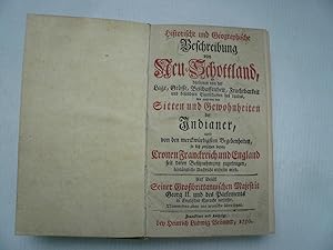
Nova Scotia, Brönner 1750+Mississipi/Louisiana, Gleditsch 1720-s
Edité par Gleditsch Leipzig
Vendeur : Hammelburger Antiquariat, Hammelburg, Allemagne
Evaluation du vendeur :
Hardcover. Etat : very good. Nova Scotia, Brönner 1750+Mississipi/Louisiana, Gleditsch 1720-s Historische und Geographische Beschreibung von Neu-Schottland : darinnen von der Lage, Grösse, Beschaffenheit, Fruchtbarkeit und besondern Eigenschaften des Landes, wie auch von den Sitten und Gewohnheiten der Jndianer, und von den merckwürdigsten Begebenheiten, so sich zwischen denen Cronen Franckreich und England seit deren Besitznehmung zugetragen, hinlängliche Nachricht ertheilet wird / Auf Befehl Seiner Großbrittannischen Majestät Georg II. und des Parlements in Englischer Sprache verfasset, Nunmehro aber ins teutsche übersetzet Erschienen Franckfurt ; Leipzig : Brönner, 1750 Umfang [2] Bl., 216 S., [1] gef. Bl. ; 8° : 1 Kt. (Kupferst.) Anmerkung Karte m.d.T.: Neueste Vorstellung des südlichen Teils von Neu-Schottland, nebst einem Plan von Neu-Hallifax / entworfen von T. Lefferys Geogr. 1750 Titelbl. in Rot- und Schwarzdruck Vorlageform d. Erscheinungsvermerks: Franckfurt und Leipzig/ bey Heinrich Ludwig Brönner, 1750 Sprache Deutsch Gattungsbegriff Geographie / Topographie Online-Ausgabe: Halle, Saale : Universitäts- und Landesbibliothek Sachsen-Anhalt, 2013 URN urn:nbn:de:gbv:3:1-517016 [info] VD18 11370998 Reference: Refractions of Canada in European Literature and Culture, (page 122: ".a first wave of publications dealing with Canada started in the 1750s. In 1750 a historical and geographical description of Nova Scotia was published in Frankfurt.") Heinz Antor, Gordon Bölling, Annette Kern-Strähler, Klaus Stierstorfer, edited by Walter de Gruyter, 2005, 309 pp. ANGEBUNDEN/BOUND WITH: Ausfuehrliche Historische und Geographische Beschreibung Des an dem grossen Flusse Mississipi in Nord-America gelegenen herrlichen Landes Louisiana : Jn welches die neu-aufgerichtete Frantzösische grosse Jndianische Compagnie Colonien zu schicken angefangen; Worbey zugleich einige Reflexionen über die weit-hinaus sehende Desseins gedachter Compagnie, Und des darüber entstandenen Actien-Handels eröffnet werden Verleger / Drucker Gleditsch, Johann Gottlieb Erschienen Leipzig : Gleditsch, 1720 Ausgabe Andere Auflage. Mit neuen Beylagen und Anmerckungen vermehret Umfang [1] gef. Bl., [3] Bl., 102 S., [4] Bl. ; 8° : 1 Kt. (Kupferst.) Vorlage des Erscheinungsvermerks: Leipzig, bey J. Fried. Gleditschens seel. Sohn, 1720. Sprache Deutsch Gattungsbegriff Geographie / Topographie / Geldwesen Online-Ausgabe Halle, Saale : Universitäts- und Landesbibliothek Sachsen-Anhalt, 2013 URN urn:nbn:de:gbv:3:1-517027 [info] VD18 10271015 Reference: Yale University Library Beinecke Rare Book & Manuscript Library "Ausfuehrliche historische und geographische beschreibung des an dem grossen flusse Mississipi in Nord-America gelegenen herrlichen landes Louisiana; in welches die neu-aufgerichtete frantzo?sische grosse indianische compagnie colonien zu schicken angefangen; worbey zugleich einige reflexionen ueber die weit-hinaus sehende desseins gedachter compagnie, und des darueber entstandenen actien-handels, ero?ffnet werden. Call Number: Zc20 720hic (Request the physical item to view in our reading room) Language: German Date: 1720. Publisher: J.F. Gleditschens seel. sohn, Edition: 3. aufl., mit neuen beylagen und anmerckungen vermehret. Subjects: Mississippi River Valley--Description and travel Louisiana--History--To 1803 Compagnie des Indes Genres: Maps in books Portraits Frontispieces (Illustrations) Type of Resource: text Description: Originally pub. Leipzig, 1720, with title: Historische und geographische Beschreibung . Cf. Sabin no. 32104. Portrait of John Law, (IN OUR BOOK LACKING) and folded map inserted at front. Map has title: Louisiana am Fluss Missisippi [!]; from the German translation of John Lawson's Carolina, Hamburg, 1712? - Cf. Winsor, The Kohl collection, p. 112. Physical Description: 3 p. l., 102 p. 17 cm." Provenienz/Provenance: Aus der Bibliothek des sachsen-weimarschen Kammerjunkers, Schriftstellers, Agrarökonomen und Gelehrten Georg.
-
Cosmographia, sive de situ orbis.
Edité par Venice, Erhard Ratdolt, 18 Juillet 1482. 1482, 1482
Vendeur : JF LETENNEUR LIVRES RARES, Saint Briac sur mer, France
Membre d'association : ILAB
Evaluation du vendeur :
Edition originale
1 vol. in-8° (218 x 158 mm) de : [1] f. (dont carte du monde gravée et rehaussée en frontispice), [46] ff. (Titre en rouge, grandes et petites lettrines gravées sur bois). Nombreuses annotations manuscrites d'époque ŕ l'encre brune dans les marges. Plein vélin ancien, tranche-fils traversant les coiffes, traces de lacets et de titrage ŕ l'encre brune. (Salissures et défauts d'usage). Premičre édition illustrée du tout premier ouvrage latin consacré ŕ la géographie, seule édition incunable ŕ contenir les deux traités du célčbre géographe romain. Pomponius Mela, qui écrivait aux alentours de 43, est le plus ancien géographe romain connu. Il donna une description qui couvre le monde connu des Gréco-Romains. On ne sait rien de lui, sinon son nom et son lieu de naissance qu'il indique lui-męme, la petite ville de Tingentera ou Cigentera dans la province de Bétique, dans la baie d'Algésiras. On date sa vie de la période de l'empereur Claude par déduction des indications géographiques qu'il donne dans ses ouvrages : la désignation de la ville d'Afrique romaine sous le nom de Césarée, nom que lui donna Juba II sous Auguste ainsi que la référence qu'il fait ŕ Cornélius Népos, écrivain décédé sous le rčgne d'Auguste. Le triomphe qui fait suite ŕ la conquęte de la Bretagne en 424, ne peut ętre que celui de Claude en vu de la remarque précédente. Pomponius Mela est l auteur qui présente le tableau le plus complet de l état de la géographie vers le milieu du Ier sičcle de l čre chrétienne. Son présent ouvrage est écrit dans un style typiquement latin et agrémenté çŕ et lŕ de métaphores. En dehors des chapitres géographiques de l'Histoire naturelle de Pline l'Ancien (oů Mela est cité comme une référence importante), le De situ orbis est le seul traité sur le sujet en latin classique. La carte du monde reliée en frontispice, gravée sur bois, d'inspiration Ptolémaďque, fut la seconde carte ŕ ętre imprimée en Italie (Campbell p.119). Elle montre l'Europe, l'Asie et la partie nord de l'Afrique, avec le Nil représenté avec comme sources dans deux lacs, l'un directement sur l'équateur, et l'autre juste au sud de celui-ci. Ces lacs se sont recoupés avec ceux que l'on appelle maintenant le lac Albert et le Victoria Nyanza, montrant que leur emplacement était supposé, sinon connu des géographes, au moins quatre sičcles avant leur découverte tardive. Au sud, des rivičres qui montent des montagnes et s'écoulent dans ces lacs, le Niger en Afrique de l'Ouest sont également représentées. Cette carte est aussi la premičre ŕ représenter la connaissance portugaise de l époque de la côte ouest de l'Afrique qui conduit six ans plus tard au franchissement du Cap de Bonne-Espérance. Campbell suggčre que l'imprimeur de l'édition, Erhard Ratdolt, pourrait avoir été le cartographe, puisque ceci et sa carte T-O de 1480 sont les deux premičres cartes de gravure sur bois imprimées en Italie. Cette carte sera copiée pour une édition de Salamanque ainsi que pour la Chronique de Nuremberg de Schedel. Premičre édition de la traduction en vers de Priscianus du De situ orbis de Dionysius; l édition de Ratdolt est la seule édition incunable ŕ contenir les deux traités géographiques. L exemplaire présente de nombreuses annotations manuscrites contemporaines dans ses larges marges. Bel exemplaire de cet ouvrage de toute rareté. 1 vol. 8vo (218 x 158 mm) of: [1] f. (including engraved and enhanced world map as frontispiece), [46] ff. (Title in red, large and small initials engraved on wood). Numerous period handwritten annotations in brown ink in the margins. Full old vellum, thread cutting through the caps, traces of laces and titling in brown ink. (Dirt and defects of use). First illustrated edition of the very first Latin work devoted to geography, the only incunable edition to contain the two treatises of the famous Roman geographer. Pomponius Mela, who wrote around 43, is the oldest known Roman geographer. He gave a description that covers the known world of the Greco-Romans. Nothing is known of him, except his name and place of birth which he indicates himself, the small town of Tingentera or Cigentera in the province of Betic, in the bay of Algeciras. His life is dated from the period of the Emperor Claudius by deduction of the geographical indications he gives in his works: the designation of the city of Roman Africa under the name of "Caesarea", name given by Juba II under Augustus. the reference he makes to Cornelius Nepos, a writer who died in the reign of Augustus. The triumph that follows the conquest of Brittany, which can only be that of Claude seen the previous remark and dates from 424. Mela is the author who presents the most complete picture of the state of geography in the middle of the first century of the Christian era. His present work is written in a typical Latin style and embellished with metaphors. Apart from the geographical chapters of the Natural History of Pline the Elder (where Mela is cited as an important reference), De situ orbis is the only treatise on the subject in classical Latin. The modified Ptolemaic map of the World was the second map to be printed in Italy (Campbell p.119). It shows Europe, Asia and the northern part of Africa, with the Nile represented with taking sources in two lakes, one directly on the equator, and the other just south of it. These lakes intersected with those now known as Lake Albert and Victoria Nyanza, showing that their location was supposed, if not known to geographers, at least four centuries before their belated discovery. To the south, rivers that rise mountains and flow into these lakes, Niger in West Africa is also represented. It is also the first map to represent the Portuguese knowledge of the time of the west coast of Africa which leads six years later to cross the Cape of Good Hope. Campbell suggests that the publisher, Erhard Ratdolt, might have been the cartographer. This map will be copied for an edition of Salamanca as well as for Schedel's Nuremberg Chro.
-
Atlas historique ou Nouvelle introduction ŕ l'histoire, ŕ la chronologie & ŕ la Geographie ancienne & moderne; Representée dans de nouvelles cartes, oů l'on remarque l'établissement des Etats & Empires du monde, leur durée, leur chűte, & leurs differens gouvernements.
Edité par Amsterdam, Les Frčres Châtelain, puis l'Honoré & Châtelain, 1708-1720., 1708
Hardcover. Etat : Fine. Amsterdam, Les Frčres Châtelain, puis l'Honoré & Châtelain, 1708-1720. 7 volumes folio (440x280mm), contemporary calf, spines gilt, red edges. Nice condition. Volume 1 second edition, volumes 2-7 first edition. Printed titles in red and black with engraved vignettes, and 283 plates (many large folding) including 100 maps, also views, natural history subjects, elaborate genealogical tables, 4 printed tables in volume 7. Sabin (America), 29141; Koeman II, pp. 33-38 A nice example of this encyclopaedic historical atlas. This atlas was intended for the general public, fascinated in the early eighteenth century by the recently conquered colonies and the new discoveries. Distant countries, such as the Americas, Africa, the Middle East, Mongolia, China, Japan, Indonesia, etc., take an important place in this work. Other sections deal with the history of the european countries, genealogy and heraldry. Volume 6 relates mostly to the Americas and contains a fine dark copy (bound in two large sheets, joined) of the Carte trčs curieuse de la Mer du Sud, depicting the history of discovery in the western hemisphere from the time of Columbus to the French explorations in North America in the late seventeenth century. In addition to the maps, many of which are based on Guillaume de l'Isle, the plates are after the best travel accounts of the period, such as those of Dapper, Chardin, de Bruyn, Le Hay and other. The atlas was published by L'Honoré & Châtelain in seven volumes in various editions from 1705 to 1739. It was compiled by Mr. C*** (anon.) with 'Dissertations', i.e. compositions of text, maps, plates and chronological and genealogical tables by Mr. Gueudeville, except volume VII where this task was taken over by H.P. Limiers. In each volume, the maps, plates and tables are numbered consecutively. In this set, the volumes are dated 1: 1713; 2 & 3: 1708; 4: 1714; 5 & 6: 1719; 7: 1720.
-
Philippi Cluveri Italia Antiqua; Opus post omnium curas elaboratissimum; tabulis geographicis aere expressis illustratum. Ejusdem Sicilia, Sardinia et Corsica. Cum Indice locupletissimo.
Edité par ex officina Elzeviri 1619-1624, Lugduni Batavorum, 1619
Edition originale
Ensemble 2 ouvrages reliés en 2 forts volumes grand in-4, reliures pleine truie ornées d'un décor estampé ŕ froid sur les plats et le dos ŕ nerfs; doublures et gardes de papier ancien crčme, tranches lisses (reliures de l'époque).Cette édition originale de Italia Antiqua est illustrée de 15 cartes sur double page. Chef d' uvre du géographe hollandais Philippi Cluwer, l'ouvrage est considéré comme une des meilleures publications consacrées ŕ la géographie de l'Italie ancienne et de ses alentours, non seulement pour la qualité de ses cartes, mais aussi pour l'érudition de ses notices qui traitent męme de l'aspect toponymique et historique. On appréciera en particulier des descriptions de la Ligurie, de la Corse et du sud-est de la France (Nice, Monaco, La Turbie, etc.). C'est le seul ouvrage terminé et complet écrit par Philippi Cluwer, qui lui a demandé un an de voyage (entrepris aux frais de l'académie de Leyde).A la suite a été reliée l'édition originale de Siciliae Antiquae, illustrée de 5 cartes gravées également sur double page.La réunion de ces deux ouvrages est rarissime.
-
Atlas universel, par M. Robert Géographe Ordinaire du Roy et par M. Robert de Vaugondy son fils Géographe ord. Du Roy
Edité par Paris
Edition originale
Etat : A. Atlas universel, par M. Robert Géographe Ordinaire du Roy et par M. Robert de Vaugondy son fils Géographe ord. Du Roy, et de S.M. Polonaise Duc de Lorraine et de Bar, et Associé de l'Académie Royale des Sciences et belles Lettres de Nancy. Avec privilčge du RoyProvenance :De la bibliothčque de S.A.S. Gabriel Junosza Podoski (Podos 1719 - Marseille 1777), archevęque de Gniezno, prince primat du royaume de Pologne et du grand-duché de Lituanie, légat du Saint-Sičge, abbé de Tyniec et de Parady (Pologne), chevalier des ordres de l'Aigle blanc de Pologne et de St André de Russie, avec ses armoiries sur les plats et une notice manuscrite d'aprčs les registres de l'abbaye royale de St Victor les Marseille collée au contreplat donnant des renseignements sur la mort du prélat.De la bibliothčque Silvy de Gravine (Marseille), avec ex-libris ŕ l'encre (XIXe) au verso de la page de garde.Un volume in-folio (53 x 37 cm) ; plein maroquin rouge aux armes de l'époque, dos ŕ 6 nerfs richement orné de caissons ŕ motifs dorés avec titre en lettres dorées, dentelle et filets dorés en encadrement des plats, filets dorés sur les coupes, armoiries dorées au centre des plats. Reliure aux armes d de S.A.S. Gabriel Junosza Podoski.Titre gravé, [2] pp. Avertissement, 40 pp. (Préface historique, Table des articles, Noms des souscripteurs.), 108 cartes doubles montées sur onglets (103+5), dont 3 dépliantes.Edition originale.Bel exemplaire de l'Atlas universel des géographes Robert de Vaugondy pčre et fils réunissant 108 cartes gravées ŕ double page sur papier fort ornées de beaux cartouches décoratifs, historiés ou allégoriques, avec les limites coloriées, toutes les cartes avec le titre au pochoir aux rectos et versos.L'atlas est illustré d'un beau titre allégorique et de 108 cartes doubles dont les 12 premičres concernent la géographie ancienne et les 96 suivantes (91+5) la géographie moderne. Parmi ces derničres : une mappemonde, 73 cartes d'Europe (France, Angleterre, Irlande, Danemark, Flandres, Luxembourg, Allemagne, Suisse, Autriche, Hongrie, Pologne, Espagne, Portugal, Italie.), 8 cartes d'Asie (Empire de Russie, Empire turc, Perse, Indes Orientales, Chine, Japon), 2 cartes d'Afrique (dont Egypte ancienne et moderne), et 7 cartes d'Amérique (Amérique septentrionale, méridionale, Canada, Virginie et Maryland, Antilles, Isles de St Domingue et Martinique, possessions anglaises). En fin d'ouvrage sont reliées 5 cartes des principales routes d'Europe : routes des postes d'Italie - d'Espagne, d'Allemagne - d'Angleterre, Ecosse et Irlande - et enfin de France. Non prévues ŕ l'origine, l'auteur indique les avoir fait graver ŕ la demande de plusieurs personnes.Les cartes sont précédées d'un essai historique en six chapitres : le premier chapitre présente l'origine et les progrčs de la géographie chez les anciens ; le deuxičme comprend l'histoire abrégée des découvertes, avec les principales navigations des anciens et des modernes, les découvertes des Espagnols, des Portugais, des Anglais, des Français et des Hollandais faisant l'objet d'articles séparés ; le troisičme chapitre traite de l'utilité de l'astronomie et des méthodes principales employées par les anciens et les modernes pour déterminer la figure de la terre et trouver les longitudes ; la quatričme partie présente les différentes méthodes employées pour représenter le globe terrestre ou une partie seulement (représentation plane ou sphérique) ; le cinquičme chapitre disserte des progrčs de la géographie en Europe, avec des articles séparés pour les artistes et géographes allemands, anglais, hollandais et flamands, espagnols, italiens, suédois et russes, ou encore français. Enfin le sixičme chapitre rend compte de l'entreprise et de l'exécution de ce nouvel atlas, avec les explications des cartes et les sources originales utilisées par les Robert de Vaugondy pčre et fils.Exemplaire bien complet du texte et des 108 cartes dans une belle reliure en maroquin rouge aux armes de Gabriel Junosza Podosk.
-
Tableaux topographiques, pittoresques, physiques, historiques, moraux, politiques, litteraires de la Suisse. [Bd. 1 (von 2)] in 4 Bdn.
Edité par Paris, Clousier,, 1780
Vendeur : Matthaeus Truppe Antiquariat, Graz, Autriche
Membre d'association : ILAB VDAO
Evaluation du vendeur :
Livre Edition originale
4 Bll., LXXIV, 176 S. 1 Kupfer-Frontisp. und 1 doppelblattgr. Kupferkarte; S. 177 - 368, LXVI S., 3 Bll. mit 1 Textabb. in Holzschnitt; 7 S., 107 Kupfertafeln (darunter 1 gefalt. Karte); 1 Bl., Kupfertafeln Nr. 109 - 217 (darunter 4 gefalt. Karten und 2 gefalt. Panoramen). Erste Ausgabe des berühmten schweizerischen Ansichtenwerkes, ohne den erst 1786 erschienen zweiten Band, der mit leicht verändertem Titel auch nur noch 32 Tafeln enthält. - Waeber I, 38. Cohen/Ricci 1075. Brunet V, 1546. ADB XLV, 507: "Ist somit diese Hauptarbeit Zurlauben s, welche zweifellos die hervorragendste aller Arbeiten geworden wäre, nicht unter die Presse gekommen, so konnte doch wenigstens ein Theil der gesammelten Materialien für das letzte Werk in großem Stile, die Tableaux topographiques de la Suisse" verwendet werden. Das Erscheinen dieser vom Generalpächter La Borde herausgegebenen reich illustrirten topographischen Gemälde traf mit Zurlauben s Abschied aus der französischen Armee mit dem Range eines Generallieutenants und seiner Uebersiedlung nach Zug (1780) zusammen. In dem genannten Prachtwerke versuchte Zurlauben insbesondere die eigene persönliche Anschauung der Schweiz, welche er von Paris aus im Urlaub so oft als möglich bereist hatte, zu verwerthen und seine Schilderung mit den ihm zur Verfügung stehenden reichen historischen Notizen zu durchweben". - Eines der bedeutendsten und am prächtigsten illustrierten Werke der Schweiz, das besonders die pittoresken Landschaften des Landes mit seinen Schlössern, Seen, Brücken, Tälern, Wasserfällen, Berggipfeln und Gletschern in den Vordergrund hebt. Der Schweizer Historiker Baron de Zurlauben (1720 - 1795) wurde von dem Geographen und Historiker J. B. de Laborde (1734 - 1794) dazu angeregt, das enzyklopädische Werk zu verfassen, dessen Herausgabe mehrere Jahre in Anspruch nahm. Zurlauben stützte sich dabei auf seine eigene, 1751 herausgegebene mehrbändige Histoire militaire des Suisses. - Die schönen Tafeln mit 308 Abbildungen überwiegen nach Le Barbier gestochen von Née, Masqualier u. a., zeigen vor allem Ansichten, darunter Aarberg, Basel, Bern, Bienne, Fribourg, Genf und Genfer See, Grindelwaldgletscher, Interlaken, Konstanz und Bodensee, Lauffen mit Rheinfall, Lugano, Murten, Neuenburg, Sankt Gotthardt, Schaffhausen, Teufelsbrücke, Yverdon-les-Bains, Vierwaldstätter See, Zürich u. v. m., darunter auch eine Panoramaansicht vom Kanton Luzern, und Gesamt- und Teilkarten von der Schweiz, ferner historische Szenen, Landestrachten, Münzen und Medaillen. Die Porträttafeln von bedeutenden Ärzten, Botanikern, Musikern, Schriftstellern u. a. illustrieren das Kapitel über die wissenschaftliche Geschichte der Schweiz. - Ohne den erst 1786 erschienen zweiten Band, der nur noch 32 Tafeln enthielt und den 1788 bei einem anderen Verleger erschienen "Table général" von Francois Antoine Quetant. - Schönes Exemplar. Leicht gebräunt und vereinzelt etw. fleckig. Die Tafel 157 mit minimalem Loch im Plattenrand. Die Tafel im Rand mit gebräunt und etw. wasserrandig. *** *** Copyright: Matthaeus TRUPPE Buchhandlung & Antiquariat - Stubenberggasse 7 - A-8010 Graz - ++43 (0)316 - 829552 *** *** Sprache: Deutsch Gewicht in Gramm: 0 Gr.-Fol. Ldr. der Zeit mit Rückenschild (Rücken fachmännisch restauriert, etw. beschabt und bestoßen).
-
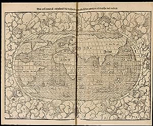
Cosmographey oder beschreibung aller Länder herrschafften, fürnemsten Stetten, geschichten, gebreüche, hantierungen etc. Beschriben durch Sebastianum Munsterum, auch durch in selbst gebessert, an welt und natürliche historie, jetzunder aber bisz auff das 1569 jar?
Date d'édition : 1569
Vendeur : Librairie Camille Sourget, Paris, France
Membre d'association : ILAB
Evaluation du vendeur :
Couverture rigide. Etat : Trčs bon. Basel, in der Officin Henricpetrina, Im Jar 1569.In-folio de (100) ff. préliminaires y compris 1 frontispice gravé, suivis de 1467 pages de texte et gravures, la derničre non chiffrée pour la marque de l'imprimeur. Plein veau brun, encadrement d'un double filet doré sur les plats ornés d'une réserve centrale dorée arabisante surmontée sur le plat supérieur des chiffres H. C. H. avec la date de 1570 frappée or dessous, dos ŕ quatre nerfs orné de fleurons ŕ froid, coiffes et coins restaurés, tranches jaspées. Intéressante et élégante reliure de l'époque.310 x 205 mm. --- Trčs rare édition non décrite par Sabin de l'un des plus célčbres ouvrages de voyages, découvertes et géographie de la Renaissance ornée de 26 cartes sur double page dont la carte du « Nouveau Monde » présentant le continent et les îles d'Amérique, 37 vues et plans de ville sur double page illustrant notamment le plus ancien plan de Paris et la premičre carte de Suisse, 3 vues de villes dépliantes (Worms, Heidelberg et Vienne), 17 vues et plans de villes ŕ pleine page, 45 autres vues de villes et prčs de 1000 gravures sur bois illustrant la spécificité des différentes régions du monde.La Cosmographia Universalis de Münster fut l'un des ouvrages les plus lus du XVIe sičcle et on peut vraisemblablement lui attribuer la seconde place en termes de popularité aprčs la Bible. Ce succčs fut en partie dű aux excellentes gravures sur bois, dont certaines de Hans Holbein le Jeune, Urs Graf, Hans Rudolph Manuel Deutsch ou encore David Kandel. Au total plus de 120 collaborateurs ont participé ŕ cette ?uvre. L'ouvrage était ŕ l'époque une référence en géographie et en histoire. On y retrouve de nombreuses illustrations des modes de vies de l'époque, de męme que des vues des villes en doubles pages et de nombreuses cartes. Ces cartes couvraient de "nouvelles îles derričre l'Espagne jusqu'ŕ l'Orient vers le pays des Indes" (l'Amérique et le contine /// Basel, in der Officin Henricpetrina, Im Jar 1569.Folio [310 x 205 mm] of (100) prel. ll. including 1 engraved frontispiece, followed by 1467 pp. of text and engravings, the last one not numbered bearing the printer's mark. Full brown calf, double gilt fillet on the covers with a gilt medallion in the center decorated in an Arabic manner, and surmounted by the monogram H.C.H. on the front cover with the date 1570 gilt-stamped underneath, spine ribbed decorated with blind-stamped fleurons, extremities of the spine and corners restored, sprinkled edges. Interesting and elegant contemporary binding. --- Very rare edition not described by Sabin of one of the most famous travel and geography books from the Renaissance, illustrated with 26 double-page maps including the map of the "New World" showing the American islands and continent, 37 views and maps of cities on double-page including for example the oldest map of Paris and the first map of Switzerland, 3 folding views of cities (Worms, Heidelberg and Vienna), 17 full-page views and maps of cities, 45 other views of cities and almost 1000 woodcuts depicting the specificities of the various regions of the world.First description of the world from a German perspective, the Cosmographia was by far the most exhaustive work published so far on the subject, compiling an incredible sum of knowledge about Europe, Asia, Africa and the New World.Munster's Cosmographia was one of the most read works in the 16th century and it occupies the second position in terms of popularity after the Bible. This huge success was partly due to the very good woodcuts, by Hans Holbein the younger, Hans Rudolph, David Kandel, Urs Graf, Manuel Deutsch and many others. More than 120 artists worked together to produce this book. This work was a reference book at the time regarding geography and history. The illustration includes a frontispiece, many double-page and folding plates, and innumerable plates figures in the text.The American part is.
-
Cosmographia [with:] De situ orbis
Edité par Erhard Ratdolt, Venice, 1482
Vendeur : Donald A. Heald Rare Books (ABAA), New York, NY, Etats-Unis
Membre d'association : ABAA ILAB
Evaluation du vendeur :
Edition originale
Two volumes in one. 4to. (7 1/2 x 5 3/4 inches). Sixth edition. A-F8. 48 ff. 96 pp. 30 lines per page. Cosmographia: 1-29 ff. De situ orbis: 30-48 ff. Full-page woodcut map of the world on a Ptolemaic cone-shaped projection with architectural border and letterpress text. Woodcut and floriated initials. Rubricated throughout. Gothic letter Latin text. Border of the woodcut map insignificantly shaved. Finely bound in green full morocco by Zaehnsdorf London with binder's ticket, gilt paneled, five raised bands forming six gilt-paneled compartments, gilt-lettered titles in second and third compartments with date in sixth, marbled endpapers, all edges sprinkled red Rare 1482 Ratdolt edition of Mela's incunable "Cosmographia," the first edition of the first Latin work dedicated to geography to include a map of the world. It is only the second woodcut world map printed in Italy. "Mela's concept of the world as published here, ten years before the discovery of the New World, was the most widely accepted cosmography in Europe." [Streeter] The present title is so foundational to our understanding of the modern world that two of the most important book collectors, E. D. Church and Thomas W. Streeter, both listed it first in their collection catalogs. For the map in this edition of Cosmographia by Mela, the earliest known Roman geographer, was the first map to incorporate knowledge from the Portuguese explorations of the West Coast of Africa. This map modified the Ptolemaic rendering of Western Africa, revealing a true Western Africa based on reports of Portugal's success further south, making it current with then-known geographical knowledge. No earlier printed map recognized this important step toward the rounding of the Cape of Good Hope, achieved by Bartolomeu Dias just six years post publication. Campbell suggests that the edition's printer, Ratdolt, may have been the mapmaker, since this and the T-O map from his 1480 edition of Rolewinck are the two earliest woodcut maps printed in Italy. The title of the map "Novellae etati ad geographie vmiculatos calles huma no viro necessarios flores aspirati votu bnmereti ponit" translates as: "If, in a new lease of life, a man seeks to attain the wormlike paths of geography, he is bound to find the flowers that belong there, for he deserves them." The map is rarely present, as Nordenskiöld relates: "The map is generally wanting, but that it really belongs to the work is shown by the watermark corresponding to the watermarks of the text." Published in the same year as Lienhart Holl's Cosmographia, Mela's world map includes additions to the Ptolemaic model. One of the more obvious changes is the addition of Scandinavia, and for the first time, the Orkney Islands off the Northeast coast of Scotland. Mela's map was cited with other early texts, including those by Macrobius, Ptolemy, Pliny, and Aristotle, as part of the reading background of Christopher Columbus, who would sail to the New World just a decade later: "In its consideration of the oceans, this work would not have been particularly useful to Columbus, but in his view of the earth, Mela raised the probablity that the Southern Hemisphere was inhabited, a novel idea for Christian believers in the biblical version of the Creation." [James Ford Bell Library] Mela, born in Spain, lived during the reign of Emperor Claudius around 40 AD. His Cosmographia was circulated in manuscript, and from the present edition, with a map. It was first printed in 1471, and it, as well as the four subsequent editions, were all without maps. Mela's was the "only formal geographical treatise in Classical Latin." [Campbell] The Cosmographia expressed concepts that were similar to those of the leading Greek geographers, yet the map which accompanies this 1482 edition exhibits the then-current school of thought, rather than Mela's own. According to Wilson, the Mela map was the model for Schedel's world map in the Nuremberg Chronicle (1493) and a Salamanca edition (1498). Within its novel architectural framework, the map is drawn on a conical projection, a modification of the Ptolemaic type. The text, a motto, the legends, and the Latin names of the winds represented by "wind heads" which surround the map are provided in letterpress. The map shows Europe, Asia (including Sri Lanka, which is drawn with a bay shaped like a keyhole), and a large part of Africa. Notable is the depiction of the Nile, with its sources in the so-called "Mountains of the Moon," by Lakes Albert and Victoria Nyanza. BMC V 286. Bod-inc M-179. BSB-Ink P-687. Brown 41. Campbell, p.119. Church 1. Essling 274. Goff M-452. GW M34876. Hain 11019. HC 11019*. ISTC im00452000. James Ford Bell Library, "The Manifest." Klebs 675.6. Nordenskiöld, p.36. Oates 1751. Polain 2661. Proctor 4385. Rhodes (Oxford Colleges) 1191. Shirley 8. Stillwell 389. Streeter Sale 1. Suarez, Shedding the Veil 7. Walsh 1809. Wilson 115.
-
Cosmographiae universalis Lib. VI.
Edité par Basel, Heinrich Petri, 1550. 1550, 1550
Vendeur : JF LETENNEUR LIVRES RARES, Saint Briac sur mer, France
Membre d'association : ILAB
Evaluation du vendeur :
1 vol in folio (327 x 215 mm) de: [12] ff., 1-474, [4], 475-480, [4], 481-1162, [2] pp.; titre entouré de 6 tableaux gravés sur bois, portrait gravé sur bois de Münster au verso; 14 cartes gravées sur bois sur double page, dont 2 cartes du monde (la premičre, de David Kandel, montrant le Nouveau Monde) et une carte des Amériques ; 39 vues de villes gravées sur bois sur double page, dont les vues « panoramiques » d'Heidelberg et de Vienne (Pages 616-618 et 682-684), chacune avec une grande vue dépliante composée de deux planches; une gravure sur bois sur double page représentant des « monstres marins et terrestres » ; environ 75 autres cartes et vues dans le texte; et environ 900 petites gravures sur bois en texte ( dont certaines répétées). Exemplaire censuré par des ratures ŕ l encre et recouverts de papier vierge aux pages : 189, 203, 223, 302, 303, 308-310, 321-322, 406, 475, 477, 478, 509, 537, 667, 874-875 et 948. Note du censeur et ex-libris du possesseur ŕ l'encre brune sur la page de garde, annotations d'époque dans la table et le texte et soulignages. (Déchirures restaurées, salissures, traces de mouillures et usures sur les bords et en marges des premiers et derniers feuillets, derničre garde postérieure). Plein veau estampé d'époque, plats ornés d'encadrements ŕ froid avec frises figurant des portraits et divers motifs, dos ŕ nerfs muet orné de filets ŕ froid, traces de fermoirs (dos anciennement refait, défauts d'usage). Premičre édition latine révisée et augmentée, de ce monumental ouvrage encyclopédique abondamment illustrée dű ŕ Sébastian Munster, rare exemplaire ayant conservé les caches de censure apposés par un juge purgatoire. Sébastian Munster (1488-1522) est un érudit polyvalent ŕ la fois cartographe, historien, astronome, mathématicien et professeur d'hébreu. Né ŕ Ingelheim sur le Rhin, il étudie l'art et la théologie ŕ Heidelberg, de 1503 ŕ 1508, et ŕ Tübingen. En 1512, il entre dans l ordre des Franciscains. Aprčs sa rencontre avec Luther, il se convertit ŕ la Réforme. De 1524 ŕ 1527, il est professeur ŕ Heidelberg. En 1528, il part enseigner la théologie et l'hébreu et les mathématiques ŕ l'université de Bâle. Il est l auteur d une « Biblia hebraďca » (1534-1535), d une grammaire et d un dictionnaire araméens. Dans son « Horologiographia » (1531-1533), il donne une forme moderne ŕ l art des cadrans solaires. Il est également l auteur d une nouvelle édition de la géographie de Ptolémée. Sa présente « Cosmographia universalis », son ouvrage majeur, sera mainte fois réédité. Publiée ŕ Bâle pour la 1čre fois en 1544 en latin, elle s'inspire du « Liber Chronicarum », aussi appelé Chronique universelle du médecin Hartmann Schedel (Nuremberg, 1493). Cette uvre collégiale monumentale est l une des premičres descriptions du monde en langue allemande. Elle dresse un état du monde au milieu du XVIe sičcle tel qu il est perçu dans l Espace rhénan, et assemble des données Géographiques, Généalogiques, zoologiques, botaniques, m urs, lois, religions, évčnements dignes de mémoire (comme le tremblement de terre ŕ Bâle). L ouvrage est un immense succčs et connait de nombreuses rééditions en latin, français, italien anglais et tchčque. Cette édition latine et l édition allemande sont publiées la męme année par le gendre de Münster, Heinrich Petri. Révisée et élargie, c est la premičre uvre de Münster ŕ contenir des vues de villes. La carte du monde moderne, « Typus Orbis Universalis », apparait également ici pour la premičre fois, remplaçant la carte du monde ptolémaďque utilisée dans les éditions précédentes (CF Shirley 77). « Pendant la majeure partie d un sičcle, [la Cosmographia de Münster] fut la principale source de connaissances géographiques, ethnographiques, historiques et scientifiques. Il s agissait d un « livre pionnier » (Wilhelm Heinricht Riehl 1873). De 1544 ŕ 1628, 36 éditions complčtes et réimpressions parurent, dont pas moins de 33 avant 1600 » (R. Oehme, introduction ŕ l'édition en fac-similé, Sebastian Munster, Cosmographei, Bâle 1550). Il fut l un des ouvrages les plus lus du xvie sičcle et on peut vraisemblablement lui attribuer la seconde place en termes de popularité aprčs la Bible. Ce succčs fut en partie dű aux excellentes gravures sur bois, dont certaines de Hans Holbein le Jeune, Urs Graf, Hans Rudolph Manuel Deutsch ou encore David Kandel. Au total plus de 120 collaborateurs ont participé ŕ cette uvre. L'ouvrage était ŕ l'époque une référence en géographie et en histoire. On y retrouve de nombreuses illustrations des modes de vies de l'époque, de męme que des vues des villes en doubles pages et de nombreuses cartes. Ces cartes couvraient de "nouvelles îles derričre l'Espagne jusqu'ŕ l'Orient vers le pays des Indes" (l'Amérique et le continent asiatique). L ouvrage comporte six parties : Livre I : Astronomie, Mathématiques, Géographie physique, Cartographie. Le livre II : Angleterre, Écosse, Irlande, Espagne, Portugal, France, Belgique, Pays-Bas, Luxembourg, Savoie, Trčves, Italie. Le livre III - Allemagne, Alsace, Suisse, Autriche, Carniole, Istrie, Bohčme, Moravie, Silésie, Poméranie, Prusse, Livonie. Livre IV: Danemark, Norvčge, Sučde, Finlande, Islande, Hongrie, Pologne, Lituanie, Russie, Valachie, Bosnie, Bulgarie, Grčce, Turquie. Livre V : Asie Mineure, Chypre, Arménie, Palestine, Arabie, Perse, Asie centrale, Afghanistan, Scythie, Tartarie, Inde, Ceylan (aujourd'hui le Sri Lanka), Birmanie, Chine, Inde de l'Est, Madagascar, Zanzibar, Amérique. Livre VI - Mauritanie, Tunisie, Libye, Égypte, Sénégal, Gambie, Mali, Afrique du Sud, Afrique de l'Est. Le présent exemplaire a le grand intéręt de conserver les stigmates de la censure religieuse pratiquée au 16éme sičcle, avec le nom du juge purgatoire l ayant expurgé inscrit sur la page de garde : Nicolas de Freising (daté du 3 aout 1796), ainsi que les caches de papier vierge apposés sur les parties du texte censuré. Un cache ôté ŕ la page 308 permet de comprendre comment le censeur opérait : préalab.
-
Cours pratique d'éducation ŕ l'usage des jeunes demoiselles, et convenable aux jeunes gens qui ne sont pas ŕ porté de suivre les études de collčge, ou qui les ont suivies sans succčs; contenant la grammaire, précédée de principes de lecture servant d'introduction; la rhétorique, l'arithmétique, la cosmographie, la géographie, l'histoire et la mythologie, traitée séparément pour l'enfance et pour l'adolescence, par demandes et par réponses. Dédié ŕ Son Altesse Royale Madame, Duchesse d'Angoulęme.Paris, Librairie d'Éducation d'Alexis Eymerie, and the author (on back of title-page: printed by J.-B. Imbert), 1816 (vol. 3!)-1817 (vols. 1-2). 3 volumes. Large 12mo (17.5 x 10.5 cm). With a large folding engraved map of France, 3 astronomical and cosmographical figures on 3 engraved plates, a large folding hierarchical "tableau synoptique" of French grammar, and numerous numerical tables and mathematical equations in the text. Contemporary richly gold-tooled, grained green morocco, each board
Vendeur : Antiquariaat FORUM BV, Houten, Pays-Bas
Membre d'association : ILAB NVVA
Evaluation du vendeur :
[4], 515, [1]; 552, [2]; 492, [2] pp.Very rare first and only edition of a compendious educational work intended for girls, dedicated (in the newly restored Bourbon monarchy) to Marie Thérčse de France (1778-1851), Duchesse d'Angoulęme and daughter of King Louis XVI and Queen Marie Antoinette, the only heir directly descended from Louis XVI to survive the Revolution. The dedication itself appears in volume 1 (1817), but is noted on all three title-pages (so also 1816). The present copy is in a beautiful armorial morocco binding clearly intended as a dedication copy for Marie Thérčse, with her arms on both boards of each volume. She had married her first cousin Louis Antoine d'Artois (1775-1844), Duc d'Angoulęme in 1799 (he was to be King of France for 20 minutes in 1830 when his father and he abdicated, then pretender to the throne, calling himself Louis XIX). She was nearly forty and childless when the book appeared, soon after the 1814/15 restoration of the Bourbon monarchy with her uncle as King Louis XVIII. Rather than impale the husband's and father's arms as the English did, French ladies displayed them side by side: courtoisie. The book contains lessons in all subjects girls of good family should be taught. The first volume covers French grammar and syntax, with separate courses for younger and older girls, followed by a basic course in rhetoric. The second volume covers arithmetic and geography in single, extensive courses. The third and last volume covers history and mythology, again with separate courses for the younger and older girls, both presented like a catechism. with questions and answers for the children to learn by heart. In fine condition with only a small tear in the folding table and occasional very minor foxing. Fine copy in a fine armorial dedication binding for the daughter of King Louis XVI in the restored Bourbon monarchy.l KVK & WorldCat (5 copies); Quérard III, p. 245; not in Gumuchian; for the arms on the binding: Olivier, Manuel armoriées Françaises 2553, fer no. 2 (recorded on a different 1816 book).
-
Séances des Écoles Normales recueillies par des sténographes et revues par les professeurs [Leçons et Débats]
Couverture rigide. Etat : Bon. 7 volumes in-8, 28 [+ 2] A Paris, chez L. Reynier [et de l'Imprimerie du cercle social], an IV [1795], , 7 volumes in-8, 28 [+ 2] planches gravées en taille-douce, 6 volumes reliés veau havane de l'époque, dos ŕ nerfs et fleuronnés, pičces de titre et de tomaison fauve ; et 1 volume broché sous couverture d'attente bleue, TRČS RARE COLLECTION COMPLČTE, EN ÉDITION ORIGINALE, DES COURS DONNÉS DANS LES ÉPHÉMČRES ÉCOLES NORMALES ; bien complčte du 7e volume de Débats, et des 28 planches gravées sur cuivre, dont 2 (planches 1 et 2 de l'histoire naturelle) sont répétées et reliées ŕ la fin du volume 6. L'ensemble comprend donc : 24 planches de Géométrie descriptive, 2 planches de mathématiques et 2 planches d'histoire naturelle. Créées le 9 brumaire an III par décret de la Convention Nationale afin de former les instituteurs de langue française, les Écoles normales ont eu une durée de vie trčs courte ; 4 mois, du 1er pluviôse au 30 floréal de l'an III (20 janvier - 19 mai 1795). MONGE Y EXPOSA SA GÉOMÉTRIE DESCRIPTIVE ET LAPLACE SON HYPOTHČSE COSMOGONIQUE. Les leçons qui étaient professées, par les savants les plus illustres, devaient ętre toutes improvisées, recueillies par la sténographie et publiées dans le journal de l'école créé ŕ cet effet, de męme que les débats ayant lieu une fois par décade, ŕ l'occasion desquels les élčves discutaient avec les professeurs. Plus de 180 cours furent ainsi donnés, par 14 professeurs nommés par décrets : Lagrange et Laplace pour les mathématiques, Monge pour la géométrie descriptive, Haüy pour la physique, Daubenton pour l'histoire naturelle, Berthollet pour la chimie, Buache et Mentelle pour la géographie, Volney pour l'histoire, Bernardin de Saint-Pierre ŕ la morale, Sicard ŕ la grammaire, Garat ŕ l'analyse de l'entendement, La Harpe pour la littérature et Vandermonde pour l'économie politique (Thouin, nommé pour l'agriculture, ne put jamais donner de cours). Ex-libris manuscrit de l'époque aux titres des 6 premiers tomes. Trčs bon exemplaire en reliure uniforme, sauf pour le tome 7, non rogné, sous couverture d'attente de l'époque (usagée). Petits accrocs au plat supérieur du tome 6 et ŕ la coiffe inférieure du tome 5. Une lacune de 2 cm environ ŕ un feuillet du tome II, avec perte de texte. Quelques annotations anciennes. Rares rousseurs. Ferdinand Buisson, Nouveau Dictionnaire de Pédagogie et d'Instruction primaire.
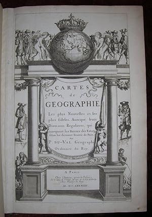

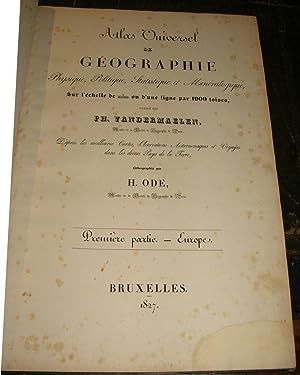
![Image du vendeur pour [MANUSCRIT] Cartes particuličres par gouvernements de la province de Dauphiné mis en vente par Pingel Rare Books](https://pictures.abebooks.com/inventory/md/md30884224826.jpg)
![Image du vendeur pour De triangulis planis et sphaericis. (.) quae extructa est ŕ Ptolemeaeo & Copernico de Revolutionibus orbium caelestium. [Avec : ] - Problematum astronomicorum et geometricorum sectiones septem. [Avec :] - In Ptolemaei magnam compositionem, quam almagestum vocant, libri tredecim mis en vente par Hugues de Latude](https://pictures.abebooks.com/inventory/md/md30050208247.jpg)
![Image du vendeur pour [Image du monde. Nouvellement imprimée a Paris par Alain Lotrian]. Sensuyt lymaige du monde contenant en soy tout le Monde mis en III parties, cestassavoir , Asie, Affrique et Europe. Avec les pays, provinces et citez et les merveilleuses et diverses creatures qui sont dedans. mis en vente par JF LETENNEUR LIVRES RARES](https://pictures.abebooks.com/inventory/md/md22846645100.jpg)

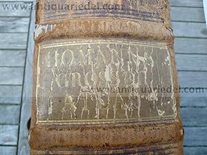
![Image du vendeur pour Voyage de découvertes aux terres Australes. Exécuté par ordre de sa Majesté l'Empereur et Roi, Sur les Corvettes le Géographe, la Naturaliste, et la Goelette le Casuarina, Pendant les Anées 1800, 1801, 1802, 1803 et 1804. [Historique] Rédigé en parti. - [THE FIRST PUBLISHED COMPLETE AND FULLY DETAILED MAPPING OF AUSTRALIA] mis en vente par Lynge & Sřn ILAB-ABF](https://pictures.abebooks.com/inventory/md/md30288308956.jpg)

![Image du vendeur pour Geographischer und Physischer Atlas von Neu-Spanien. gegründet auf astronom: trigonom: und Barometer Messunden [old ink mss.]. mis en vente par Altea Antique Maps](https://pictures.abebooks.com/inventory/md/md31449501850.jpg)
![Image du vendeur pour I. Geographiae libri octo, recognitiam diligenter. [II. Galliae Tabule Geographicae. Belgii Inferiores Geographicae Tabule]. mis en vente par JF LETENNEUR LIVRES RARES](https://pictures.abebooks.com/inventory/md/md22846645099.jpg)
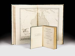
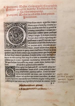
![Image du vendeur pour Cosmographia [with:] De situ orbis mis en vente par Donald A. Heald Rare Books (ABAA)](https://pictures.abebooks.com/inventory/md/md31814926085.jpg)
![Image du vendeur pour Séances des Écoles Normales recueillies par des sténographes et revues par les professeurs [Leçons et Débats] mis en vente par Librairie Alain Brieux](https://pictures.abebooks.com/inventory/md/md19067026752.jpg)