Montant total (1 article articles) :
Destination de la commande :

geographie, Edition originale (Plus de 26 000 résultats)
Passer aux résultats principaux de la recherche
Type d'article
- Tous les types d'articles
- Livres (25 557)
- Magazines & Périodiques (98)
- Bandes dessinées (1)
- Partitions de musique
- Art, Affiches et Gravures (41)
- Photographies (5)
- Cartes (304)
-
Manuscrits &
Papiers anciens (7)
Etat
Reliure
Particularités
- Edition originale
- Signé (673)
- Jaquette (3 667)
- Avec images (15 494)
- Sans impression ŕ la demande (26 008)
Livraison gratuite
Pays
Evaluation du vendeur
-
Cartes de Geographie Les plus Nouvelles et les plus Fideles
Edité par Paris: Chez l'Auteur, 1679., 1679
Vendeur : Arader Galleries - AraderNYC, New York, NY, Etats-Unis
Evaluation du vendeur :

Edition originale
Du VAL, Pierre (1619-1683). Cartes de Geographie Les plus Nouvelles et les plus fideles, Avecque leurs Divisions Regulieres, qui marquent les Bornes des Estats selon les derniers Traites de Paix. Paris: Chez l'Auteur, 1679. Folio (17 x 12 2/8 inches). Engraved "Introduction", "Alphabet et Definition des Termes", "Table Generale de Geographie", "Les Tables de Geographie reduites en un Jeu de Cartes" and two sheets of a games related to the German Empire (uncoloured), and one of place-names for Les Conciles; engraved allegorical title-page, fine double-page engraved double-hemisphere world map "Planisphere, ou Carte Generale de Monde", "Carte Universelle du Commerce", 1677 (Shirley 465, second state), and 89 double-page engraved maps, all with original hand-colour in outline. 19th-century tree sheep backed marbled paper boards, the spine in six compartments, with five raised bands, the second with maroon morocco lettering-piece, the others decorated with fine gilt tools (extremities a little scuffed, small abrasion to lower cover). Provenance: with 19th-century marginal manuscript scholarly annotations to L'Amerique autrement le Nouveau et Indes Occidentales Du Val's EXTREMELY RARE "Cartes Geographiques" (Pastoureau Duval II), was the only folio atlas published by him. It was initially a collection of du Val's own maps, with those of other authors, published in 1654, then 1665 and 1667. In 1677 du Val published a uniform collection of his grand four-part wall, and folio maps, with the allegorical frontispiece as here: an architectural border supporting two putti unveiling a large globe to a world of assorted grandees; beneath the pillared arch repose a gentleman traveller, a merchant with this bags of salt and pepper, a scientist illuminating his own hand, and a curious woman tending to her animals. The maps in this example of the "Cartes Geographiques" are EXCEPTIONALLY FINE, bright, clean and attractive examples, with original hand-colouring in outline, and include 2 world maps, double-hemisphere and on a Mercaor projection, 7 of his spectacular wall maps, 3 sheets of games, that seem to be the equivalent of our "Risk", and 89 detailed double-page maps, each detailed, but also beautiful for their elegant simplicity. Pierre du Val was the nephew of the celebrated French cartographer Nicolas Sanson d'Abbeville (1600-1667), mapmaker to Louis XIV, King of France, and responsible for sparking a renaissance in geographical endeavor in France, and laying the foundations for French domination in map production, initiating the so-called "French school of cartography," a school that was unprecedented in its attention to precision and scientific detail and which discarded much of the decorative embellishments of previous maps as irrelevant. Du Val adopted Sanson's geographical conceptions, confirming that the center of cartographic innovation had shifted from Holland to France. Du Val too was appointed to the position of Geographe ordinaire to Louis XIV, and justifiably so. The maps include, in order: - World maps: Planisphere, ou Carte Generale de Monde (Duval II D), double-hemisphere world map, surrounded by diagrams showing compass points, winds and planetary orbits, a small terrestrial globe and an armillary sphere - Carte Universelle du Commerce, Carte Hidrographique, ou. Les Costes des 4 Parties du Monde, Avecque les Routes pour la Navigation des Indes, Occidentales et Orientales 1677 (Shirley 465, second state, first published in 1674), on Mercator s projection showing the French and English routes to and from the East and West Indies, complete with galleons in full sail, the track of Le Maire across the Pacific, and an anonymous attempt to find a route to China and Japan through Hudson s Bay in 1665. This map perpetuates the myth that California is an island, and displays some of the misunderstandings about the largely unexplored northwest coast of North America, such as the Straits of Anian. The lower half of the map is do.
-

Geographie opus nouissima traductione e Grecorum archetypis castigatissime pressum
Edité par Johann Schott, 1513
Vendeur : Arader Galleries - AraderNYC, New York, NY, Etats-Unis
Evaluation du vendeur :
Livre Edition originale
Hardcover. Etat : Near Fine. 1st Edition. THE DuPONT COPY. Folio (18 1/2 x 12 1/2 in.; 469mm x 317mm). 47 woodcut maps by Martin Waldseemüller (all but 2 double-page) including "Tabula terre nove," the last map ("Lotharingia") printed in colors, 4 woodcut diagrams in text, one large woodcut of an armillary sphere on K1; lower portion of the title-page renewed with 12 lines of text on verso supplied in excellent pen-work facsimile, lower portion of last leaf renewed, without the final blank leaf, some browning and staining, a few leaves skillfully repaired affecting the image in 3 maps: Italy, Switzerland and the Upper Rhineland. Contemporary blind-stamped paneled calf over wooden boards, each cover decorated with alternating fillets of a stag and hunter, and a thistle and bird roll tool, fore-edge lettered in Greek: "Ptolemaio," original vellum page-markers; brass catches and clasps and cornerpieces renewed to style, recently and expertly conserved by James and Stuart Brockman Ltd, full report available upon request. THE FIRST "MODERN" EDITION OF PTOLEMY AND "THE MOST IMPORTANT OF ALL PTOLEMY EDITIONS" (Streeter Sale I:6). The first modern atlas, prepared by Martin Waldseemüller using the translation of Mathias Ringmann. This is one of the most important editions of Ptolemy, containing many new regional maps: twenty new maps based on contemporary knowledge "unlike many of the alleged 'new' maps produced by earlier editors, [they] contained a great deal of new information, and in nearly every case they were decided improvements over anything that had been previously offered" ("The World Encompasssed," 56), and were included in addition to the traditional body of twenty-seven Ptolemaic maps derived from the 1482 Ulm edition (or possibly from the manuscript atlas of Nicolaus Germanus that served as a source for the latter). Schott's edition while initiated by the most famous of all early sixteenth-century cosmographers, Martin Waldseemüller and his associate Mathias Ringmann, partly at the expense of Duke René of Lorraine, was brought to completion by Jacobus Eszler and Georgius Ubelin. THE FIRST MAP IN AN ATLAS ENTIRELY DEVOTED TO AMRERICA. The atlas contains "Tabula terre nove." Often called the "Admiral's map" after Columbus, unlike its predecessor by Peter Martyr, it shows the continental Atlantic seaboard, with a continuous coastline stretching from the mouth of the Rio de la Plata to the St. Lawrence River. Although not to scale the map depicts a complete Gulf of Mexico. The island of Cuba is here named Isabella after Queen Isabella of Spain, who funded Columbus's expedition of 1492. The first issue of Waldseemüller's map published in 1507 introduced for the first time "America" to name South America, but in this atlas issue he acknowledges Columbus's discovery with the legend: "Hec terra cum adiacentib insulis inuenta est per Columbus ianuensem ex mandato Regis Castelle" (This land with its adjacent islands was discovered by Columbus, sent by the king of Castile). The map of Lotharingia (the first map of the Duchy of Lorraine), printed in black, red and olive, is one of the earliest examples of color-printing. This edition was reprinted in 1520 using the same woodcut blocks. REFERENCES: Fairfax Murray, German 348 and 348A; Harrisse 74; Phillips 359; Sabin 66478; Shirley 34 PROVENANCE: Copious contemporary marginal scholarly annotations in Greek and Latin; Pierre S. du Pont III (1911-1988), his sale, (Collection of Navigation, Christie's 8 October 1991, lot 214).
-
Cartes generales de la geographie ancienne et nouvelle ou les empires, monarchies, Royaumes
Edité par Paris: The author and Pierre Mariette, 1675., 1675
Vendeur : Arader Galleries - AraderNYC, New York, NY, Etats-Unis
Evaluation du vendeur :
Edition originale
2 volumes in one. Folio (18 x 12 5/8 inches). Letterpress title-page to each volume and "Liste des Cartes", folding letterpress "Catalogues des Cartes Geographiques des Dieurs Jaillot Geographes Ordinaires du Roy" dated 1778 and with price-list in manuscript, bound at the beginning. 83 FINE folding engraved maps of the new and ancient world, with contemporary hand-colour in outline. Contemporary speckled calf (rebacked to style). First edition. Containing maps dating from 1652-1669, and particularly related to the Americas: three world maps "Harmonie ou Correspondance du Globe" (1659), "Mappemonde ou carte generale" (1669) (cf.Shirley 419), and " L'Hydrographie ou description de L'Eau" (1652) each showing California as an island, the last also one of the earliest obtainable maps to show the 5 Great Lakes; "Amerique Septentrionale" (1669), Burden's first state (404); "Le Canada, ou Nouvelle France" (1656); "Le Nouveau Mexique et la Floride" (1656), first state, engraved by Somer, and a cornerstone map of California and the Southwest, based on the Blaeu world map of 1648; "Mexicque ou Nouvelle Espagne" (1656); "Les Isles Antilles" (1656); "Amerique Meridionale" (1669); "Terre Ferme ou sont les Governations, ou Gouvernemens de Terre Ferme, Cartagene, St. Marthe, Rio De la Hache, Venezuela, Nouvelle Andaluise, Popyan" (1656); "Partie de Terre Ferme ou sont Guiane et Caribane" (1656); "Le Perou et le course de la Rivre Amazone" (1656); "Le Chili" (1669); "Le Bresil" (1656); "Le Paraguay" (1668); "Le Terre et les Isles Magellaniques" (1668). The maps were compiled by Nicolas Sanson who first published his atlas in 1654, with 100 maps, and engraved and printed by Pierre Mariette; each held the copyright to half of the maps which bear their separate imprints, and were issued progressively from 1630. Born in Abbeville, a town in the Picardy region of France, in 1600, Sanson was the most noted French cartographer in modern history. Mapmaker to Louis XIV, King of France, Sanson endowed his maps with the most recent geographical information as well as the finest and sharpest engraving of the period. His "Cartes Generales de Toutes les Parties du Monde" was the most important single product of French commercial cartography of the seventeenth century. Sanson sparked a renaissance in geographical endeavor in his native country, which had not been a major player on the international cartographic stage since the great Oronce Finé in the sixteenth century. With this atlas, Sanson laid the foundations of French domination in map production, initiating the so-called "French school of cartography," a school that was unprecedented in its attention to precision and scientific detail and discarded much of the decorative embellishments of previous maps as irrelevant. From Sanson's time in the second half of the seventeenth century until the latter part of the eighteenth century, French geographical conceptions were more influential than those put forward by any other nation. With this landmark atlas, Sanson all but single-handedly caused the center of cartographic innovation to shift from Holland to France. Philips 486. Catalogued by Kate Hunter.
-
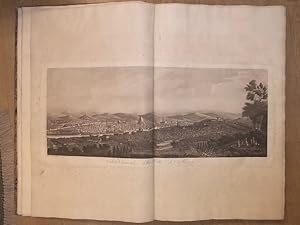
The Holy Land, Syria, Idumea, Arabia, Egypt & Nubia. With historical descriptions by George Croly and William Brockedon.
Edité par London, Moon, 1842 - 1849., 1842
Vendeur : Matthaeus Truppe Antiquariat, Graz, Autriche
Membre d'association : ILAB VDAO
Evaluation du vendeur :
Livre Edition originale
6 Bde. 3 Bll., 30 S., 21 Bll.; 23 Bll.; 2 S., 18 Bll.; 2 Bll., 8 S., 21 Bll.; 22 Bll.; 24 Bll. mit 120 Textabb. 3 Frontisp., 6 Titel, 1 Porträt, 118 Tafeln (alles in getönter bzw. farbig getönter Lithographie von Louis Hague), 2 Kupferkarten. Erste Ausgabe dieses epochalen Tafelwerks über den Nahen Osten mit allen 248 Ansichten des Heiligen Landes (in getönten Lithos) und Ägyptens (in farbig getönten Lithos). - Blackmer 1432. Lipperheide 1590 und 1591. Röhricht 1983. Abbey, Travel, 385 und 272. - "David Roberts was the first professional artist to visit the Near East without a patron or a connection to a military expedition or missionary group. He sailed to Alexandria in 1838 and for eleven months traveled up the Nile River, across deserts and mountains, through Egypt and the Holy Land, to arrive in Jerusalem on Easter 1839. He continued north to Lebanon and departed from Beirut in May. Roberts recorded his impressions of landscapes, temples, ruins, and people in three sketchbooks and more than 272 watercolors. These sketches and paintings provided the basis for the 247 lithographs published with text between 1842 and 1849 as the three-volume "Holy Land." The images were produced by Louis Haghe, the best and most prolific lithographer of the time. Originally from Tournai, Belgium, Haghe moved to England before 1825 and established himself as specialist of the hand-tinted lithograph. His sensitive handling of the lithographer`s tools imparts a range of tonality and color as well as a sense of the delicacy and spontaneous quality of Roberts`s original images. Roberts`s plates are among the most popular images of famous sites in the Near East. As John Ruskin wrote they make "true portraiture of scenes of historical and religious interest. They are faithful and laborious beyond any outlines from nature I have ever seen." (ww.metmuseum.org). - "In point of bulk and ambition Roberts`s Holy Land was one of the most important and elaborate ventures of nineteenth-century publishing, and it was the apotheosis of the tinted lithograph. There is pleasure to be had from many of the individual plates, where Haghe`s skilful and delicate lithography, and his faithful interpretation of Roberts`s draughtsmanship and dramatic sense, combine in what are undoubtedly remarkable examples of tinted lithographic work. Particularly in the Egypt and Nubia section, one feels that the colossal subjects and broad vistas were ideally suited to Roberts`s talent, trained as he was in theatrical scene-painting during his early days in Carlisle, Glasgow, Edinburgh, and London.Roberts was fully appreciative of Haghe`s work, writing that: `Haghe has not only surpassed himself, but all that has hitherto been done of a similar nature. He has rendered the views in a style clear, simple, and unlaboured, with a masterly vigour and boldness which none but a painter like him could have transferred to stone`" (Abbey 341). - Das Werk erschien in insgesamt 3 Varianten: Die kolorierte Subskribtions-Ausgabe (mit den 2 Bll. "Subskribenten-Verzeichnis"), eine Ausgabe mit farbigen getönten Lithographien und eine Ausgabe mit getönten Lithographien. Vorliegend ist eine Mischausgabe, die Ägypten Bände enthalten die farbig getönten Lithos, die Bände des heiligen Landes mit den getönten Lithos. - Titel mit hs. Namen. Teils etw. wasserrandig. Durchgehend fleckig, vereinzelt im weißen Rand stark fleckig. *** *** Copyright: Matthaeus TRUPPE Buchhandlung & Antiquariat - Stubenberggasse 7 - A-8010 Graz - ++43 (0)316 - 829552 *** *** Sprache: Deutsch Gewicht in Gramm: 0 Gr.-Fol. OHLdr. (restauriert, fleckig, Rücken mit ergänzten Fehlstellen).
-
Description de l'Égypte ou Recueil des observations et des recherches qui ont été faites en Egypte .
Edition originale
Couverture rigide. Etat : Trčs bon. Edition originale. 24 tomes de texte en 26 volumes in-8 et 11 volumes grand in-folio d'atlas (10 de planches et un atlas géographique).Demi-veau bleu glacé, dos lisses avec titres et tomaison en lettres dorées, plats recouverts de papier marbré bleu (reliure de Tessier relieur et doreur se S.A.R. le Duc d'Orléans, avec son étiquette au contreplat supérieur du volume Antiquités 1). (Dos des atlas refaits, plats conservés avec quelques restaurations de papier ; rares rousseurs légčres, frontispice restauré). SECONDE EDITION de ce monument de l'histoire du livre comprenant 994 planches.L'ouvrage comprend: Texte: Antiquités. Description - 5 volumes. Antiquités. Mémoires - 4 volumes illustrés de 13 tableaux, 5 planches et 1 carte. Etat Moderne - 8 tomes en 10 volumes illustrés de 45 planches (en 25 feuilles), 17 tableaux (en 17 feuilles) et 2 cartes (ancienne et comparée de l'Egypte, - de la Basse-Egypte). Histoire Naturelle - 6 volumes illustrés de 2 tableaux (en 4 feuilles) et 1 planche. Explication des planches - 1 volume Atlas: Antiquités - 5 volumes illustrés du frontispice, 420 planches (compris le portrait de Louis XVIII) et un tableau. Etat Moderne - 2 volumes illustrés de 189 planches sur 181 feuilles. Histoire Naturelle - 2 tomes en 3 volumes illustrés de 245 planches. Atlas géographique - 1 volume illustré de 53 cartes et planches dont titre gravé ŕ double page.Soit un total de 908 planches in-folio, auxquelles il faut rajouter l'illustration des volumes in8, soit 3 cartes, 32 tableaux et 51 planches.Trčs bel exemplaire. La Description de l'Egypte est le résultat de la collaboration des savants, artistes et techniciens qui suivirent Bonaparte en Egypte. C'est L'OUVRAGE LE PLUS MONUMENTAL JAMAIS CONSACRE A UN PEUPLE. Monge et Denou en furent les maîtres d'?uvre.Votée par le Directoire en avril 1798, l'expédition militaire en Egypte menée par Bonaparte se double d'une expédition scientifique.Pour cela, Bonaparte crée une commission des sciences et des arts composée de savants et experts ; au total, 167 personnes, toutes disciplines confondues, vont faire partie de l'expédition : physiciens, peintres, naturalistes, dessinateurs, mathématiciens, astronomes, géographes, architectes, sculpteurs, hommes de lettres, imprimeurs, etc. parmi lesquels Jacques Barraband, Geoffroy Saint Hilaire, Jules-César Savigny, Pierre-Joseph Redouté, Vivant Denon, Conté, Méchain, etc. Deux mois aprčs leur arrivée en Egypte, Bonaparte crée l'Institut d'Egypte dans le but de consigner, reproduire et répertorier les travaux et recherches des savants dans les domaines multiples et variés de l'antiquité, l'architecture, la langue, l'artisanat, la musique, l'industrie, la minéralogie, la médecine, etc. Malgré tous les obstacles, l'expédition réussit ŕ ramener une quantité de documents impressionnante et inédite. C'est grâce ŕ la compétence de tous ces hommes que cette ?uvre monumentale a pu voir le jour.Publiée tout d'abord en 1809, la Description de l'Egypte ou Recueil des observations et des recherches qui ont été faites en Egypte pendant l'expédition de l'armée française se divise en 4 grandes sections : l'Egypte Ancienne (antiquités), l'Egypte Moderne, l'Histoire Naturelle et la géographie.La seconde édition, dite de Panckoucke, de plus petit format, parut entre 1821 et 1829.La Description de l'Egypte ou Recueil des observations et des recherches qui ont été faites en Egypte pendant l'expédition de l'armée française CONSTITUE AUJOURD'HUI ENCORE UNE SOURCE DOCUMENTAIRE DE PREMIER ORDRE, nombre d'édifices représentés sur les planches ayant été complčtement détruits par la suite. Atabey, 343 (1st edition) ; Brunet, II, 617. // ENGLISH // 24 volumes of text in 26 volumes in-8 and 11 volumes large in-folio of atlases (10 of plates and a geographical atlas).Half blue glazed calf, smooth spines with titles and tomaison in gilt letters, boards covered with blue marbled paper (binding by Tessier, binder and gilder to H.R.H. the Duke of Orleans, with his label on the upper fro.
-
Atlas Universel De Geographie Physique, Politique, Statistique et Mineralogique Sur L'echelle De 1/1641836 Ou D'une Ligne Par 1900 Toises
Edité par Brussels: [P.M.G. Vandermaelen,] 1827., 1827
Vendeur : Arader Galleries - AraderNYC, New York, NY, Etats-Unis
Evaluation du vendeur :
Livre Edition originale
Hardcover. Etat : Good. 1st Edition. 6 volumes. Folio (21 1/8 x 14 inches). 7 lithographed index maps, one chart of comparative altitudes of mountains, and 382 double-page lithographed maps by Henri Ode and Vandermaelen, hand-colored in outline (lower outer blank corners of first 3 leaves in volume I renewed without loss, some foxing on title-pages, to text leaves, to the general map of North America, and to Asia no. 8 (part of Russia). Contemporary green straight-grain morocco, gold-tooled border and corners (quite worn, backstrips detached or torn, edges and covers scuffed). Provenance: from the library of the Onondaga Historical Association, with their bookplate and library stamps on the end-leaves. THE FIRST LITHOGRAPHED ATLAS First edition. Vandermaelen, a renowned Belgian cartographer, who is known for his many detailed maps of Brussels, built one example of the monumental globe that the maps in these volumes were designed to create. It required the building of a custom-made room, within Vandermaelen's own spacious Geographical Institute, and measured more than 23 feet in diameter. As such it remains the largest image of the earth's surface available to a 19th century audience. As a result of its large size, and uniform scale this atlas is very important for its large scale depiction of newly discovered and developed areas, including the American West, the Far East and Australia. Koeman I Vdm 1; NMM III 179; Philips, Atlases 747; Tooley 311.
-
De triangulis planis et sphaericis. (.) quae extructa est ŕ Ptolemeaeo & Copernico de Revolutionibus orbium caelestium. [Avec : ] - Problematum astronomicorum et geometricorum sectiones septem. [Avec :] - In Ptolemaei magnam compositionem, quam almagestum vocant, libri tredecim
Edité par (Heinrich Petri & Peter Perna), Basel, 1561
Vendeur : Hugues de Latude, Villefranche de Lauragais, France
Membre d'association : ILAB
Evaluation du vendeur :
Edition originale
*** Premičre édition donnée par Daniel Santbech de cet ouvrage de Regiomontanus. Il l'a revu et commenté ŕ la lumičre des découvertes de Copernic. Rédigé en 1464, ce texte n'a été publié pour la premičre fois qu'en 1533 ŕ Nuremberg. Illustré de trčs nombreux bois gravés dans le texte. Relié ŕ la suite : - SANTBECH. Problematum astronomicorum et geometricorum sectiones septem. Basileae, Per Henrichum Petri, et Petrum Pernam, 1561. In-folio de (20), 294, (2) pp. Premičre édition. Une suite de l'ouvrage précédent, qui traite des applications pratiques. La plus grande partie est consacrée ŕ l'astronomie et ses instruments. L'auteur traite aussi des cadrans solaires, de géographie, de navigation, d'arpentage, de balistique. Le mathématicien et astronome Daniel Santbech était hollandais. En 1651, Riccioli a donné son nom ŕ un cratére de la Lune. Relié avec : - REGIOMONTANUS, PEURBACH. In Ptolemaei magnam compositionem, quam almagestum vocant, libri tredecim. Conscripti ŕ Joanne Regiomontano . ; in quibus vniversa doctrina de coelestibus motibus, magnitudinibus, eclipsibus &c., in epitomen redacta, proponitur. Nuremberg, J. Berg, U. Neuber, 1550. In-folio de (116) ff. Troisičme édition de la premičre traduction complčte, donnée par Peurbach et Regiomontanus ŕ partir d'un manuscrit grec découvert ŕ Byzance. (La premičre Venise, 1496, la 2e Bâle, 1543). Titre en noir et rouge et nombreux bois gravés dans les marges. Exemplaire dans une magnifique reliure en maroquin aux armes et au chiffre de JACQUES-AUGUSTE DE THOU. Ce volume porte ses seules armes et a donc été relié avant 1587, date de son premier mariage. Jacques-Auguste de Thou (1553-1617) commença sa collection vers 1573. Ce fameux bibliophile a rassemblé des milliers de livres sur tous les sujets, mais, il est cependant rare de rencontrer un livre de science portant ses armes. Celui-ci a été particuličrement bien relié, dans un maroquin précieux, probablement de Turquie. *** In-folio de (8), 146, (38) pp. Maroquin citron, dos ŕ nerfs orné du chiffre de Thou, plats aux armes du męme, encadrements dorés, (Reliure de l'époque.) - - - - - - - - - - - - - - - - - - - - - - - - - - - - - - - - - - - - - - - - - - - - - - - - - - - - - - - - - - - - - - - - - - - - * Copy from the famous library of Jacques Auguste de Thou, in a splendid morroco binding. First edition given by Daniel Santbech. He revised and augmented this work by Regiomontanus, according to Copernicus' discoveries. Written in 1464, it was published for the first time in 1533 in Nuremberg. "The first systematic treatise on plane and spheric trigonometry to be published in Europe. (.) With 'De triangulis' trigonometry was established as an independent discipline. Regiomontanus' original purpose, however, had been to furnish astronomers with a mathematical technique essential for their studies, and in this De triangulis had a success perhaps greater than its author could have dreamed of. For in 1539 Georg Joachim Rheticus presented a copy of the work's 1533 edition as a gift to Copernicus. The great astronomer had already written the trigonometrically-based portion of his De Revolutionibus without knowledge of his predecessor's treatise. After reading the new book, Copernicus modified the presentation of several of his own indispensable theorems by inserting two leaves in the manuscript of the De Revolutionibus. Hence, Rheticus' remark that Regiomontanus began the reconstruction of astronomy that Copernicus completed takes on a fuller meaning." (Rose, The Italian Renaissance of Mathematics). Bound with: - SANTBECH. Problematum astronomicorum and geometricorum sectiones septem . Basileae, Per Henrichum Petri, and Petrum Pernam, 1561. First edition. A continuation with practical applications of the previous work. Most of the book is devoted to astronomy and its instruments. The author also deals with sundials, geography, navigation, surveying, ballistics . Daniel Santbech (fl. 1561) was a Dutch mathematician and astronomer. In 1651, Riccioli gave his name to a crater on the Moon. Both volumes are illustrated with many woodcuts in text. Bound with: - REGIOMONTANUS, PEURBACH. In Ptolemaei magnam compositionem, quam almagestum vocant, libri tredecim. Nuremberg, Apud Ioannem Montanum & Ulricum Neuberum, 1550. Third edition of the first complete translation of Ptolemy, given by Peurbach and Regiomontanus from a Greek manuscript discovered in Byzantium. (The first Venice, 1496, the 2nd Basel, 1543). Title in black and red and many wood cuts in the margins. Contemporary yellow morroco, spine gilt with nerves, arms of de Thou gilt on boards. Splendid copy with a distinguished provenance. - -.
-
Expédition dans les parties centrales de l'Amérique du Sud, de Rio de Janeiro a Lima, et de Lima au Para; exécutée par ordre du gouvernement Français pendant les années 1843 a 1847. Paris, P. Bertrand, 1850-1859
Edité par P. Duménil, Paris, 1840
Livre Edition originale
Hardcover. Etat : Very Good. First Edition. 7 parts in 13 volumes. 8vo (6 vols.), 4to (6 vols.), folio 1 Vol. With 441 lithographed and tinted lithographed plates and maps, including 401 partly or completely hand-coloured. Original red 3/4 morocco. The most important scientific expedition to South America in the 19th century, led by the French naturalist Francis de Castelnau (1810-1880) First part Histoire du Voyage 8vo, 6Vol. (7), 467pp., 485pp, 483pp, 467pp, 480pp, 432pp folding map. Second part Vues et scenes : 4to, 14pp 59 of 60 engraved plates (lacks #58) Third part Antiquites des Incas : 4to, (4), 7pp, 60 of 62 engraved plates (lacks #19 and #29) Fourth part Itineraires e coupes geologiques :Folio, 8pp, 76 maps, plans and views, partly or completely hand-coloured, Fifth part Geographie des parties centrales : Folio, 10pp, (1), 29 of 30 double page maps (lacks #12) outlined in color and partly hand-coloured Sixth part Botanique : 4to, (1), 90 engraved plates (lacks text and vol 2 of text) Seventh part Vol 1 : Zoologie Animaux, nouveaux ou rares : 4to. Anatomie (8), 100pp, 18 engraved plates (1 hand colored), Mammifčres (2), 116pp 13/20 engins plates (lacks #1 to #7), Oiseaux (2), 98pp, (1), 8/20 engraved plates (lacks #1 to 12). Seventh part Vol 2 Poissons (13), 113pp, 50 engraved plates, Reptiles (1), 95pp, 18 engraved plates. Seventh part Vol 3 Entomologie : 204pp, 20 engraved plates François de Castelnau (December 25, 1810 - February 4, 1880) was a French naturalist, born in London (some sources give his year of birth in 1812). Also known as François Laporte or Francis de Castelnau. Born in London, illegitimate son of the Countess of Mesnard-La Barotičre, daughter of the Duke de La Force, widow after several years. He studied natural history in Paris. From 1837 to 1841 he made a scientific expedition to Canada where he studied the fauna of the Canadian lakes and the political systems of Canada and the United States. From 1843 to 1847, with two botanists and a taxidermist, he crossed South America from Peru to Brazil, following the Amazon River and the La Plata river systems, the scientific results of this expedition are of considerable importance. Besides the zoological, botanical, mineralogical and ethnographical collections he brought to Europe, Castelnau provided a wealth of information with the astronomical, barometrical, hydrographical and hydraulic observations and determinations he made. The beautifully coloured plates make it a desired work for bibliophiles as well. During their travels Castelnau and his men gathered an enormous amount of information through meteorological, magnetic, botanical and zoological observations. He served as a French consul in Bahia in 1848; in Siam from 1848 to 1862, and in Melbourne, Australia from 1864 to 1877, where he died in 1880. Borba de Moraes, pp. 167-168; Howgego, 1800-1850, C14; Nissen, ZBI 88-89; Sabin 11411.
-
De mirabilibus quae mundi.
Edité par Venice, Nicolaum Jenson, 1473. 1473, 1473
Vendeur : JF LETENNEUR LIVRES RARES, Saint Briac sur mer, France
Membre d'association : ILAB
Evaluation du vendeur :

Edition originale
1 vol. in-folio (285 x 182 mm) de : [1] f. bl. ; [2] ff. ; [1] f. ll. [63] ff. ; [1] f. bl. Texte imprimé sur 33 lignes. Emplacement des lettrines demeuré vierge. Annotations en marge ŕ l'encre brune ŕ chaque page. Exemplaire portant dans les marges les trous des punaises qui servaient aux premiers imprimeurs ŕ positionner les ff. sur la presse. Plein veau ancien (circa 1800), dos ŕ nerfs titré ŕ l'or, roulette sur les coupes. (Dos restauré, accidents aux coins, rares taches ou rousseurs). Provenance: Clifford Rattey (ex-libris, collection dispersée par Maggs); W.R.H. Jeudwine (ex-libris, sa vente Sotheby s Londres, 18 septembre 1984, lot 28); George Abrams (ex-libris, sa vente Sotheby s Londres, 16 novembre 1989, lot 118); Maria Ludovica Borromeo Arese et Massimiliano Favia del Core (ex-libris). Premičre édition de "De Mirabilibus quae mundi", uvre majeure du grammairien et compilateur romain Gaius Julius Solinus, dans lequel cet auteur, qui a vécu au IVe sičcle aprčs JC, résume sa vision du monde ŕ partir de diverses sources telles que Pline, Pomponius Mela, Cornelius Bocchus et d'autres. L ouvrage est rédigé sous la forme d'une collection de curiosités en histoire naturelle, géographie et histoire. La compilation de Solinus sur les merveilles du monde a connu une large diffusion ŕ travers le Moyen Âge. Des citations de l ouvrage par des auteurs tels qu'Augustine, Isidore et Bede attestent de son influence depuis une date précoce et un grand nombre de manuscrits du IXe sičcle et plus tardifs témoignent de sa popularité continue. Les récits les plus saisissants et pittoresques de l ouvrage ont été transférés presque dans leur intégralité sur les cartes médiévales. L ouvrage est une des sources possibles des plus anciennes cartes du monde conservées telle que la célčbre « Mappa mundi » d'Albi (produite au VIIIe sičcle, plus ancienne carte du monde conservée), ou encore la « mappa mundi » de la cathédrale de Hereford, datée de la fin du XIIIe sičcle. (C.R. Beazeley, The Dawn of Modern Geography, I, 1987, pp.247-272). Son agencement géographique dérive en grande partie de l'histoire naturelle de Pline et de la géographie de Mela. Elle revęt une importance mondiale, ŕ la fois pour les différents pays qu'elle représente dont elle est souvent la premičre représentation conservée, pour la mémoire du monde, et pour l'histoire de la cartographie mondiale. Quand parait l ouvrage, cela fait moins de 20 ans que la Bible de Gutenberg a été imprimée : c est l époque de la genčse de l imprimerie et de la typographie dont, l imprimeur de ce livre, Nicolas Jenson (1420 - 1480) est un des précurseurs. Jenson est un graveur qui commence sa carričre d imprimeur en 1458 lorsque Charles VII l envoie ŕ Mayence pour « secrčtement » s informer sur les techniques d impression de Gutenberg. Ŕ la suite de son séjour en Allemagne, Jenson exerça l essentiel de sa carričre d imprimeur ŕ Venise et mit au point des caractčres romains qui permettaient de minimiser la quantité d encre utilisée (trčs chčre ŕ l époque) tout en augmentant la lisibilité du texte. Grâce ŕ sa parfaite maîtrise des caractčres, les historiens de la typographie considčrent que ce sont les caractčres d imprimerie les plus parfaits jamais gravés. Jenson imprimera plus de 150 ouvrages au cours de sa vie et inspira le typographe du journal The Times ŕ créer sa célčbre police qu il baptisa New Roman en l honneur de Jenson. « De Mirabilia mundi » a également été imprimée ŕ Paris la męme année par Louis Simonel "Au Soufflet Vert", toutes les autres éditions sont postérieures. Exemplaire bien complet des 68 feuillets, dont 3 blancs. Édition d une extręme rareté : seuls 2 exemplaires sont passés en vente publique ces 50 derničres années, dont un en 2011 en mauvais état et incomplet de 2 des feuillets blancs. Notre exemplaire a conservé ses larges marges qui sont abondamment annotées par une main contemporaine. Dans ces marges, on trouve également les trous de punaises caractéristiques des débuts de l impression qui permettaient de guider la presse pour que les feuillets soient imprimés uniformément. Provenance: Clifford Rattey (ex-libris, collection dispersée par Maggs); W.R.H. Jeudwine (ex-libris, sa vente Sotheby s Londres, 18 septembre 1984, lot 28); George Abrams (ex-libris, sa vente Sotheby s Londres, 16 novembre 1989, lot 118); Maria Ludovica Borromeo Arese et Massimiliano Favia del Core (ex-libris) 1 vol. in-folio (285 x 182 mm) of : [1] f. bl. ; [2] ff. ; [1] f. ll. 63] ff ; [1] bl. f. ; [1] f. ll. Text printed on 33 lines. Location of the ornamental initial remained blank. Annotations in the margins in brown ink on each pages. Copy with the pin holes in the margins, which were used by the first printers to position the ff. on the press. Full calf binding circa 1800. First edition of "De mirabilibus quae mundi", major work of the grammarian and roman compiler gaius julius solinus, in which this author, who lived in the 4th century, summarizes his vision of the world from various sources such as pliny, pomponius mela, cornelius bocchus and others. The work is written in the form of a collection of curiosities in natural history, geography and history. The compilation of solinus on the wonders of the world was widely distributed throughout the middle ages. Quotes from the book by authors such as augustine, isidore and bede attest its influence from an early date and a large number of manuscripts from the ninth century and later attest its continued popularity. The most striking and picturesque accounts of the work were transferred almost in their entirety to medieval maps. The book is one of the possible sources of the oldest preserved maps of the world such as the famous "mappa mundi" of albi (produced in the 8th century, the oldest preserved map of the world), or even the "mappa mundi" of the cathedral. Of hereford, dated from the end of the 13th century. (c.r. Beazeley, the dawn of modern geography, i, 1987, pp. 247-272): its geographical arrang.
-
Geographischer und Physischer Atlas von Neu-Spanien. gegründet auf astronom: trigonom: und Barometer Messunden [old ink mss.].
Date d'édition : 1812
Vendeur : Altea Antique Maps, London, Royaume-Uni
Membre d'association : ABA ILAB PBFA
Evaluation du vendeur :
Edition originale
Tubingen bey J.C. Cotta, 1810 [old ink mss.]. Folio, contemporary half calf with marbled boards, maroon morocco gilt title label on front board; title in old ink mss on front endpaper. Plates numbered 1-20 (6-8 on one sheet): a two-sheet folding map, 4 double-page maps, 6 single page maps, 4 double-page cross sections with hand colour, 2 sepia aquatint views of volcanos, 1 engraved table. With the bookplate of Gustav Parthey. Two Prussian passports for Parthey, dated 1858 & 1867, loosely inserted. Binding scuffed, contents clean and in very good condition. The complete set of plates from Humboldt's famous 'Atlas Géographique et Physique du Royaume de la Nouvelle-Espagne', the plate volume of his 'Essai politique sur le royaume de la Nouvelle-Espagne'. It has a German translation of the title in manuscript with the name of Cotta, publisher of the true first edition of the 'Essai politique', which was suppressed by Humboldt himself because of a dedication to Charles IV of Spain, who had been forced to abdicate by Napoleon in 1808. The 'Essai politique' was an account of Humboldt's expedition to Mexico in 1803-4 with botanist Aimé Bonpland. During the trip he accurately measured the longitude of Acapulco (plate 18), drew the two-sheet 'Carte Generale du Royaume de la Nouvelle Espagne' the most accurate map of Mexico (and Texas) and the four-sheet profile of Mexico, the first complete profile of any country. The bookplate is of the library of Gustav Friedrich Konstantin Parthey (1798-1872), art historian, owner of the Nicolaische Buchhandlung in Berlin, and correspondent of Humboldt's. He wrote an extensive transcript of Humboldt's 'Kosmos' lectures at the Berlin University, 'Vorlesungen uber physikalische Geographie', 1827-1828. Parthey also compiled a catalogue raisonné of the etchings of Wenceslaus Hollar in 1853, a reference still in use today. He joined Humboldt as a member of the Prussian Academy of Sciences in 1857.
-
I. Geographiae libri octo, recognitiam diligenter. [II. Galliae Tabule Geographicae. Belgii Inferiores Geographicae Tabule].
Edité par Cologne, Gottfried von Kempen, 1584 / Duisburg, [1585-1602]. 1584, 1602
Vendeur : JF LETENNEUR LIVRES RARES, Saint Briac sur mer, France
Membre d'association : ILAB
Evaluation du vendeur :
Edition originale
3 parties en 1 vol in-folio (410 x 280 mm) de: [2] ff. (titre gravé et enluminé et feuillet préliminaire) ; 106 pp. (nombreux schémas dans le texte) ; [16] ff. (index, 1 tableau sur pleine page) ; [5] ff. (f. blanc, titre, privilčge et schéma gravé sur pleine page) ; 27 cartes sur double page en beaux coloris d'époque avec description de chacune au dos ; 1 carte dépliante avec description ; [15] ff. (index) ; [10] ff. (titre gravé, privilčge, avis au lecteur et index) ; 23 cartes sur double page avec description de chacune au dos ; 1 carte ŕ pleine page avec description. (Rares traces de mouillures, corps d'ouvrage frais). Plein veau XVIIe, dos ŕ nerfs orné, titre de maroquin rouge, roulette dorée sur les coupes, tranches jaspées rouges. (Discrčtes restaurations aux coiffes et aux coins) Premičre édition avec la traduction de la géographie de Ptolémée par Pirckheimer, éditée par Arnold Mylius, exemplaire avec 28 cartes en superbes coloris d époque. Gerard Mercator (1512-1594), surnommé par Ortelius "le Ptolémée de notre temps", gravait ces plaques de cuivre dans le cadre d'une cosmographie qu'il comptait publier en cinq volumes. Le temps et l'effort mis par Mercator dans sa révision de Geographia de Ptolémée faisaient partie d'un grand projet qui occupa la plus grande partie de sa vie. Mercator avait pour projet de produire un ouvrage donnant la géographie et l histoire des mondes antique et moderne. Sa carte générale Ptolémaďque est l'une des plus belles jamais produite. Les plaques de Mercator étaient si parfaites que 7 autres éditions en seront tirées. Adams P-2232; Sabin 66490; Koeman Me2; Shirley 139. 3 parts in 1 vol in-folio of: [2] ff. ; 106 pp. ; [16] ff. ; [5] ff. ; 27 maps on double page in beautiful period colors with description of each one on the back; 1 folding card with description; [15] ff. ; [10] ff. ; 23 maps on double page with description of each one on the back; 1 full-page map with description. 17th century calf, decorated ribbed spine, red morocco title, gilt roulette on the cuts, red marbled edges. (Discreet restorations to the caps and corners). First edition, with the translation of the geography of Ptolemy by Pirckheimer, edited by Arnold Mylius, copy with the 27 maps in beautiful contemporary colors. Gerard Mercator (1512-1594), named by Ortelius "the Ptolemy of our time", engraved these copper-plates as part of a cosmography that he intended to publish in five volumes. Mercator's time and effort in revising Ptolemy's Geographia was part of a larger project that occupied most of his life. Mercator's plan was to produce a work on the geography and history of the ancient and modern worlds. His general Ptolemaic map is one of the most beautiful ever produced. The plates of Mercator were so perfect that 7 other editions were made with them. [bound with Mecator Galliae Tabule Geographicae. 24 engraved maps].
-
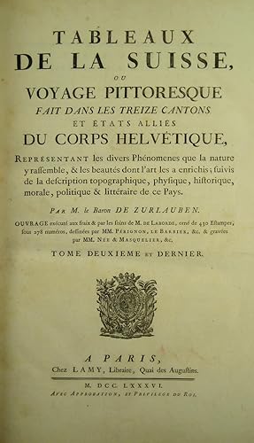
Tableaux topographiques, pittoresques, physiques, historiques, moraux, politiques, littéraires, de la Suisse (vol. I); (and:) Tableaux de la Suisse ou voyage pittoresque fait dans les treize cantons et états alliés du Corps hélvetique; (followed by) Table analytique et raisonnée des Tableaux de la Suisse . par (F.A.) Quétant (vol. II); Tableaux de la Suisse, ou Voyage pittoresque fait dans les treize cantons et états alliés du Corps Helvétique (vol. 3: plates).
Edité par Paris, Clousier, Lamy, 1780
Vendeur : Hellmut Schumann Antiquariat, Zurich, Suisse
Membre d'association : ILAB VEBUKU
Evaluation du vendeur :
Edition originale Signé
With frontispiece after Moreau le jeune engr. by Née, engr. title with view by Née, and 430 copper engravings numbered 1-278. Large folio. 19th century red morocco, spines with gilt lettering, gilt borders on covers, gilt inner dentelles, t.e.g., signed Koehler on spine of vol. I (somewhat rubbed, a few spots). Exlibris Christopher Tynor, Stoke Rochford Library, Lincolnshire. Paris, Clousier, Lamy, 1780-88. First edition. A nice copy of this precious and classic work on Switzerland, with fine views drawn by Bertaux, Besson, Brandoin, Châtelet, S.H. Grimm, Le Barbier, Pérignon, a.o., and engraved by Née, Niquet, Alix, de Longueil, Dequevauviller, Droyer, Borguet, Masquelier, Choffard, Aveline, a.o. Many leaves have two or more engravings, the numbering is sometimes repeated, sometimes there are several numbers on one leaf. There are 7 double-page maps (included in the numbering) by Clermont, one after Daniel Bruckner, one a view after B. A. Dunker. The plate volume has, on half-title verso, the portrait-medallions of Zurlauben and Laborde (no. 278 in the plate index). The majority of plates show picturesque views of the most famous places in Switzerland, some show historical events, portraits of eminent citizens, coins and seals, etc. Zurlauben (1720-1799) published the first volume anonymously making it seem is if it was Laborde's work. The second volume with a slightly different title bears Zurlauben's name. His monumental work offers a wealth of facts about Switzerland, and is a testimony to his vast erudition. He cites sources and writes with ease, but with a serious approach which earned him the esteem of fellow scholars at home and abroad. The work is dedicated to the count of Artois, Colonel-General of Switzerland. - Cohen/de Ricci 1075; Lewine 581; Lonchamp 3362; Haller I, 235; Wäber 38; Reynaud 573; Fürstenberg 46, 101, 110, 151; Feller/Bonjour 505f.; Brunet V, 1546; Barth 17338. GEOGRAPHY:TRAVEL ; HELVETICA: ALLGEMEIN ; GEOGRAPHIE, REISEN ; GRAPHIC ARTS:ILLUSTRATED BOOKS ;
-
Voyage de découvertes aux Terres Australes, exécuté sur les corvettes le Géographe, le Naturaliste, et la goélette le Casuarina, Pendant les années 1800, 1801, 1802, 1803 et 1804 ; sous le commandement du capitaine de vaisseau N. Baudin. Navigation et géographie. Publié par ordre de son excellence le ministre de la marine et des colonies ; et rédigé par M. Louis FREYCINET (Avec un Atlas.)
Edité par A Paris, De L Imprimerie Royale, [1812]-1815., 1815
Vendeur : LIBRAIRIE HÉRODOTE JEAN-LOUIS CECCARINI, Paris, France
Membre d'association : ILAB
Evaluation du vendeur :
Livre Edition originale
Couverture rigide. Etat : Trčs bon. Edition originale. 1 volume in-quarto de texte et atlas in-folio [partie navigation et géographie] ; XVI- 576 pp.-(1)et 1 atlas [595 x 445 mm] imprimé ŕ la date de 1812 se compose ainsi : 1 page de grand titre gravée [écrite par Louis Freycinet et gravée par Lale et Giraldon avec une vignette par Lesueur]-1 f. non chifré [Table des Cartes et Plans]-32 cartes hors texte [1-32]. Un demi-veau glacé havane ŕ petits coins vélin, dos lisse joliment orné, filets or, fleurons or, trčs rare reliure uniforme de l époque car le volume de texte et l atlas ont été édités séparément. ÉDITION ORIGINALE FORT RARE, VOIRE RARISSIME. LE PREMIER ATLAS DE L'AUSTRALIE DRESSÉ PAR LES FRANÇAIS sous le commandement de Nicolas Baudin, capitaine de vaisseau qui accomplit un remarquable travail d exploration de 1800 ŕ 1804 sur les côtes sud et ouest de l Australie alors nommée Terre de Napoléon, ouvrant la voie ŕ une connaissance complčte et exacte des abords de l Australie et de la Tasmanie. Le complément indispensable ŕ la relation de MM. Peron & Freycinet : « Voyage de découvertes aux Terres Australes, A Paris, De l Imprimerie Royale, 1816-17 ». RARISSIME. FIRST EDITION VERY SCARCE.
-
Cosmographia, sive de situ orbis.
Edité par Venice, Erhard Ratdolt, 18 Juillet 1482. 1482, 1482
Vendeur : JF LETENNEUR LIVRES RARES, Saint Briac sur mer, France
Membre d'association : ILAB
Evaluation du vendeur :
Edition originale
1 vol. in-8° (218 x 158 mm) de : [1] f. (dont carte du monde gravée et rehaussée en frontispice), [46] ff. (Titre en rouge, grandes et petites lettrines gravées sur bois). Nombreuses annotations manuscrites d'époque ŕ l'encre brune dans les marges. Plein vélin ancien, tranche-fils traversant les coiffes, traces de lacets et de titrage ŕ l'encre brune. (Salissures et défauts d'usage). Premičre édition illustrée du tout premier ouvrage latin consacré ŕ la géographie, seule édition incunable ŕ contenir les deux traités du célčbre géographe romain. Pomponius Mela, qui écrivait aux alentours de 43, est le plus ancien géographe romain connu. Il donna une description qui couvre le monde connu des Gréco-Romains. On ne sait rien de lui, sinon son nom et son lieu de naissance qu'il indique lui-męme, la petite ville de Tingentera ou Cigentera dans la province de Bétique, dans la baie d'Algésiras. On date sa vie de la période de l'empereur Claude par déduction des indications géographiques qu'il donne dans ses ouvrages : la désignation de la ville d'Afrique romaine sous le nom de Césarée, nom que lui donna Juba II sous Auguste ainsi que la référence qu'il fait ŕ Cornélius Népos, écrivain décédé sous le rčgne d'Auguste. Le triomphe qui fait suite ŕ la conquęte de la Bretagne en 424, ne peut ętre que celui de Claude en vu de la remarque précédente. Pomponius Mela est l auteur qui présente le tableau le plus complet de l état de la géographie vers le milieu du Ier sičcle de l čre chrétienne. Son présent ouvrage est écrit dans un style typiquement latin et agrémenté çŕ et lŕ de métaphores. En dehors des chapitres géographiques de l'Histoire naturelle de Pline l'Ancien (oů Mela est cité comme une référence importante), le De situ orbis est le seul traité sur le sujet en latin classique. La carte du monde reliée en frontispice, gravée sur bois, d'inspiration Ptolémaďque, fut la seconde carte ŕ ętre imprimée en Italie (Campbell p.119). Elle montre l'Europe, l'Asie et la partie nord de l'Afrique, avec le Nil représenté avec comme sources dans deux lacs, l'un directement sur l'équateur, et l'autre juste au sud de celui-ci. Ces lacs se sont recoupés avec ceux que l'on appelle maintenant le lac Albert et le Victoria Nyanza, montrant que leur emplacement était supposé, sinon connu des géographes, au moins quatre sičcles avant leur découverte tardive. Au sud, des rivičres qui montent des montagnes et s'écoulent dans ces lacs, le Niger en Afrique de l'Ouest sont également représentées. Cette carte est aussi la premičre ŕ représenter la connaissance portugaise de l époque de la côte ouest de l'Afrique qui conduit six ans plus tard au franchissement du Cap de Bonne-Espérance. Campbell suggčre que l'imprimeur de l'édition, Erhard Ratdolt, pourrait avoir été le cartographe, puisque ceci et sa carte T-O de 1480 sont les deux premičres cartes de gravure sur bois imprimées en Italie. Cette carte sera copiée pour une édition de Salamanque ainsi que pour la Chronique de Nuremberg de Schedel. Premičre édition de la traduction en vers de Priscianus du De situ orbis de Dionysius; l édition de Ratdolt est la seule édition incunable ŕ contenir les deux traités géographiques. L exemplaire présente de nombreuses annotations manuscrites contemporaines dans ses larges marges. Bel exemplaire de cet ouvrage de toute rareté. 1 vol. 8vo (218 x 158 mm) of: [1] f. (including engraved and enhanced world map as frontispiece), [46] ff. (Title in red, large and small initials engraved on wood). Numerous period handwritten annotations in brown ink in the margins. Full old vellum, thread cutting through the caps, traces of laces and titling in brown ink. (Dirt and defects of use). First illustrated edition of the very first Latin work devoted to geography, the only incunable edition to contain the two treatises of the famous Roman geographer. Pomponius Mela, who wrote around 43, is the oldest known Roman geographer. He gave a description that covers the known world of the Greco-Romans. Nothing is known of him, except his name and place of birth which he indicates himself, the small town of Tingentera or Cigentera in the province of Betic, in the bay of Algeciras. His life is dated from the period of the Emperor Claudius by deduction of the geographical indications he gives in his works: the designation of the city of Roman Africa under the name of "Caesarea", name given by Juba II under Augustus. the reference he makes to Cornelius Nepos, a writer who died in the reign of Augustus. The triumph that follows the conquest of Brittany, which can only be that of Claude seen the previous remark and dates from 424. Mela is the author who presents the most complete picture of the state of geography in the middle of the first century of the Christian era. His present work is written in a typical Latin style and embellished with metaphors. Apart from the geographical chapters of the Natural History of Pline the Elder (where Mela is cited as an important reference), De situ orbis is the only treatise on the subject in classical Latin. The modified Ptolemaic map of the World was the second map to be printed in Italy (Campbell p.119). It shows Europe, Asia and the northern part of Africa, with the Nile represented with taking sources in two lakes, one directly on the equator, and the other just south of it. These lakes intersected with those now known as Lake Albert and Victoria Nyanza, showing that their location was supposed, if not known to geographers, at least four centuries before their belated discovery. To the south, rivers that rise mountains and flow into these lakes, Niger in West Africa is also represented. It is also the first map to represent the Portuguese knowledge of the time of the west coast of Africa which leads six years later to cross the Cape of Good Hope. Campbell suggests that the publisher, Erhard Ratdolt, might have been the cartographer. This map will be copied for an edition of Salamanca as well as for Schedel's Nuremberg Chro.
-
Philippi Cluveri Italia Antiqua; Opus post omnium curas elaboratissimum; tabulis geographicis aere expressis illustratum. Ejusdem Sicilia, Sardinia et Corsica. Cum Indice locupletissimo.
Edité par ex officina Elzeviri 1619-1624, Lugduni Batavorum, 1619
Edition originale
Ensemble 2 ouvrages reliés en 2 forts volumes grand in-4, reliures pleine truie ornées d'un décor estampé ŕ froid sur les plats et le dos ŕ nerfs; doublures et gardes de papier ancien crčme, tranches lisses (reliures de l'époque).Cette édition originale de Italia Antiqua est illustrée de 15 cartes sur double page. Chef d' uvre du géographe hollandais Philippi Cluwer, l'ouvrage est considéré comme une des meilleures publications consacrées ŕ la géographie de l'Italie ancienne et de ses alentours, non seulement pour la qualité de ses cartes, mais aussi pour l'érudition de ses notices qui traitent męme de l'aspect toponymique et historique. On appréciera en particulier des descriptions de la Ligurie, de la Corse et du sud-est de la France (Nice, Monaco, La Turbie, etc.). C'est le seul ouvrage terminé et complet écrit par Philippi Cluwer, qui lui a demandé un an de voyage (entrepris aux frais de l'académie de Leyde).A la suite a été reliée l'édition originale de Siciliae Antiquae, illustrée de 5 cartes gravées également sur double page.La réunion de ces deux ouvrages est rarissime.
-
Atlas universel, par M. Robert Géographe Ordinaire du Roy et par M. Robert de Vaugondy son fils Géographe ord. Du Roy
Edité par Paris
Edition originale
Etat : A. Atlas universel, par M. Robert Géographe Ordinaire du Roy et par M. Robert de Vaugondy son fils Géographe ord. Du Roy, et de S.M. Polonaise Duc de Lorraine et de Bar, et Associé de l'Académie Royale des Sciences et belles Lettres de Nancy. Avec privilčge du RoyProvenance :De la bibliothčque de S.A.S. Gabriel Junosza Podoski (Podos 1719 - Marseille 1777), archevęque de Gniezno, prince primat du royaume de Pologne et du grand-duché de Lituanie, légat du Saint-Sičge, abbé de Tyniec et de Parady (Pologne), chevalier des ordres de l'Aigle blanc de Pologne et de St André de Russie, avec ses armoiries sur les plats et une notice manuscrite d'aprčs les registres de l'abbaye royale de St Victor les Marseille collée au contreplat donnant des renseignements sur la mort du prélat.De la bibliothčque Silvy de Gravine (Marseille), avec ex-libris ŕ l'encre (XIXe) au verso de la page de garde.Un volume in-folio (53 x 37 cm) ; plein maroquin rouge aux armes de l'époque, dos ŕ 6 nerfs richement orné de caissons ŕ motifs dorés avec titre en lettres dorées, dentelle et filets dorés en encadrement des plats, filets dorés sur les coupes, armoiries dorées au centre des plats. Reliure aux armes d de S.A.S. Gabriel Junosza Podoski.Titre gravé, [2] pp. Avertissement, 40 pp. (Préface historique, Table des articles, Noms des souscripteurs.), 108 cartes doubles montées sur onglets (103+5), dont 3 dépliantes.Edition originale.Bel exemplaire de l'Atlas universel des géographes Robert de Vaugondy pčre et fils réunissant 108 cartes gravées ŕ double page sur papier fort ornées de beaux cartouches décoratifs, historiés ou allégoriques, avec les limites coloriées, toutes les cartes avec le titre au pochoir aux rectos et versos.L'atlas est illustré d'un beau titre allégorique et de 108 cartes doubles dont les 12 premičres concernent la géographie ancienne et les 96 suivantes (91+5) la géographie moderne. Parmi ces derničres : une mappemonde, 73 cartes d'Europe (France, Angleterre, Irlande, Danemark, Flandres, Luxembourg, Allemagne, Suisse, Autriche, Hongrie, Pologne, Espagne, Portugal, Italie.), 8 cartes d'Asie (Empire de Russie, Empire turc, Perse, Indes Orientales, Chine, Japon), 2 cartes d'Afrique (dont Egypte ancienne et moderne), et 7 cartes d'Amérique (Amérique septentrionale, méridionale, Canada, Virginie et Maryland, Antilles, Isles de St Domingue et Martinique, possessions anglaises). En fin d'ouvrage sont reliées 5 cartes des principales routes d'Europe : routes des postes d'Italie - d'Espagne, d'Allemagne - d'Angleterre, Ecosse et Irlande - et enfin de France. Non prévues ŕ l'origine, l'auteur indique les avoir fait graver ŕ la demande de plusieurs personnes.Les cartes sont précédées d'un essai historique en six chapitres : le premier chapitre présente l'origine et les progrčs de la géographie chez les anciens ; le deuxičme comprend l'histoire abrégée des découvertes, avec les principales navigations des anciens et des modernes, les découvertes des Espagnols, des Portugais, des Anglais, des Français et des Hollandais faisant l'objet d'articles séparés ; le troisičme chapitre traite de l'utilité de l'astronomie et des méthodes principales employées par les anciens et les modernes pour déterminer la figure de la terre et trouver les longitudes ; la quatričme partie présente les différentes méthodes employées pour représenter le globe terrestre ou une partie seulement (représentation plane ou sphérique) ; le cinquičme chapitre disserte des progrčs de la géographie en Europe, avec des articles séparés pour les artistes et géographes allemands, anglais, hollandais et flamands, espagnols, italiens, suédois et russes, ou encore français. Enfin le sixičme chapitre rend compte de l'entreprise et de l'exécution de ce nouvel atlas, avec les explications des cartes et les sources originales utilisées par les Robert de Vaugondy pčre et fils.Exemplaire bien complet du texte et des 108 cartes dans une belle reliure en maroquin rouge aux armes de Gabriel Junosza Podosk.
-
Voyage autour du monde, fait dans les années 1803, 1804, 1805 et 1806, par les ordres de sa majesté impériale Alexandre Ier, empereur de Russie, sur les vaisseux la Nadiejeda et la Neva.
Edité par Paris: Gide fils, 1821, 1821
Vendeur : Peter Harrington. ABA/ ILAB., London, Royaume-Uni
Membre d'association : ABA ILAB PBFA
Evaluation du vendeur :
Edition originale
First edition in French of the first Russian circumnavigation, one of the most significant Pacific voyages after Cook, presented here in superior condition in a choice period binding, complete with the rare atlas of plates, "very important and. difficult to obtain" (Hill). A highly desirable set. Krusenstern (Ivan Fedorovich Kruzenshtern, 1770-1846) had served in the British Navy between 1793 and 1799. He was given command of the two-ship expedition under "a brilliant corps of officers" (Hill), intended to establish trade with China and Japan, facilitate trade in South America, and examine California for a possible colony. His expedition encompassed the Canary Islands, Brazil, the Marquesas, Kamschatka, Nagasaki, Sakhalin, and Macao. "The voyage made a significant contribution to the knowledge of the hydrography of the Pacific coast of North America. Krusenstern took the first Russian embassy of Nikolai Rezanov to Japan" (Howgego). The first edition, published at St Petersburg between 1809 and 1814 with a folio atlas of 105 plates, and issued in both Russian and German, is a signal rarity of travel literature. Editions in Dutch, English and Italian followed, although none were accompanied by a plate volume, which marks the present first edition in French as being the first edition following the original publication to include an atlas of plates. The illustrations are re-drawn versions of images in the original, and includes a portrait of Krusenstern, views and images of native people of the Marquesas, Japan, Sakhalin Island, Kamtchatka, etc., as well as nine maps. The translation is by the French geographer Jean-Baptiste Benoît Eyričs (1776-1846), a founder member of the Société de Géographie, a member of the Société Asiatique and Académie des Inscriptions et Belles-Lettres, awarded the Legion of Honour, and in 1841 elected a Foreign Honorary Member of the American Academy of Arts and Sciences. However, he is best remembered for a non-geographical work: his Fantasmagoriana (1812), an anthology of German ghost stories, was read by the Byron-Shelley circle during their stay at the Villa Diodati, the most famous child of that famous excursion being Mary Shelley's Frankenstein. Arctic Bibliography 9377; Forbes 530; Hill 952; Howes K 272; Lada-Mocarski 61 and 62; Nissen, Zool., 2310; Sabin 38332. 2 octavo volumes letterpress (199 x 123 mm), atlas volume of plates (425 x 280 mm). Contemporary dark green half straight-grain calf, flat spines gilt lettered direct and divided into compartments by zig-zag rolls, two broad panels filled with a reticulated pattern highlighted with a quatrefoil device at the interstices, sailing ship motif in third and sixth compartments, green vellum corner tips, green marbled sides. 30 plates in the atlas, including lithograph portrait of Krusenstern by G. Engelmann after Baptiste, 19 lithograph plates and 10 engraved maps (3 double-page). Vol. I with superficial crack and minor wear at head of front joint, a few light abrasions to spine of atlas, occasional toning and scattered foxing. An excellent set, with the half-titles in the letterpress volumes.
-
Tableaux topographiques, pittoresques, physiques, historiques, moraux, politiques, litteraires de la Suisse. [Bd. 1 (von 2)] in 4 Bdn.
Edité par Paris, Clousier,, 1780
Vendeur : Matthaeus Truppe Antiquariat, Graz, Autriche
Membre d'association : ILAB VDAO
Evaluation du vendeur :
Livre Edition originale
4 Bll., LXXIV, 176 S. 1 Kupfer-Frontisp. und 1 doppelblattgr. Kupferkarte; S. 177 - 368, LXVI S., 3 Bll. mit 1 Textabb. in Holzschnitt; 7 S., 107 Kupfertafeln (darunter 1 gefalt. Karte); 1 Bl., Kupfertafeln Nr. 109 - 217 (darunter 4 gefalt. Karten und 2 gefalt. Panoramen). Erste Ausgabe des berühmten schweizerischen Ansichtenwerkes, ohne den erst 1786 erschienen zweiten Band, der mit leicht verändertem Titel auch nur noch 32 Tafeln enthält. - Waeber I, 38. Cohen/Ricci 1075. Brunet V, 1546. ADB XLV, 507: "Ist somit diese Hauptarbeit Zurlauben s, welche zweifellos die hervorragendste aller Arbeiten geworden wäre, nicht unter die Presse gekommen, so konnte doch wenigstens ein Theil der gesammelten Materialien für das letzte Werk in großem Stile, die Tableaux topographiques de la Suisse" verwendet werden. Das Erscheinen dieser vom Generalpächter La Borde herausgegebenen reich illustrirten topographischen Gemälde traf mit Zurlauben s Abschied aus der französischen Armee mit dem Range eines Generallieutenants und seiner Uebersiedlung nach Zug (1780) zusammen. In dem genannten Prachtwerke versuchte Zurlauben insbesondere die eigene persönliche Anschauung der Schweiz, welche er von Paris aus im Urlaub so oft als möglich bereist hatte, zu verwerthen und seine Schilderung mit den ihm zur Verfügung stehenden reichen historischen Notizen zu durchweben". - Eines der bedeutendsten und am prächtigsten illustrierten Werke der Schweiz, das besonders die pittoresken Landschaften des Landes mit seinen Schlössern, Seen, Brücken, Tälern, Wasserfällen, Berggipfeln und Gletschern in den Vordergrund hebt. Der Schweizer Historiker Baron de Zurlauben (1720 - 1795) wurde von dem Geographen und Historiker J. B. de Laborde (1734 - 1794) dazu angeregt, das enzyklopädische Werk zu verfassen, dessen Herausgabe mehrere Jahre in Anspruch nahm. Zurlauben stützte sich dabei auf seine eigene, 1751 herausgegebene mehrbändige Histoire militaire des Suisses. - Die schönen Tafeln mit 308 Abbildungen überwiegen nach Le Barbier gestochen von Née, Masqualier u. a., zeigen vor allem Ansichten, darunter Aarberg, Basel, Bern, Bienne, Fribourg, Genf und Genfer See, Grindelwaldgletscher, Interlaken, Konstanz und Bodensee, Lauffen mit Rheinfall, Lugano, Murten, Neuenburg, Sankt Gotthardt, Schaffhausen, Teufelsbrücke, Yverdon-les-Bains, Vierwaldstätter See, Zürich u. v. m., darunter auch eine Panoramaansicht vom Kanton Luzern, und Gesamt- und Teilkarten von der Schweiz, ferner historische Szenen, Landestrachten, Münzen und Medaillen. Die Porträttafeln von bedeutenden Ärzten, Botanikern, Musikern, Schriftstellern u. a. illustrieren das Kapitel über die wissenschaftliche Geschichte der Schweiz. - Ohne den erst 1786 erschienen zweiten Band, der nur noch 32 Tafeln enthielt und den 1788 bei einem anderen Verleger erschienen "Table général" von Francois Antoine Quetant. - Schönes Exemplar. Leicht gebräunt und vereinzelt etw. fleckig. Die Tafel 157 mit minimalem Loch im Plattenrand. Die Tafel im Rand mit gebräunt und etw. wasserrandig. *** *** Copyright: Matthaeus TRUPPE Buchhandlung & Antiquariat - Stubenberggasse 7 - A-8010 Graz - ++43 (0)316 - 829552 *** *** Sprache: Deutsch Gewicht in Gramm: 0 Gr.-Fol. Ldr. der Zeit mit Rückenschild (Rücken fachmännisch restauriert, etw. beschabt und bestoßen).
-
Cosmographia [with:] De situ orbis
Edité par Erhard Ratdolt, Venice, 1482
Vendeur : Donald A. Heald Rare Books (ABAA), New York, NY, Etats-Unis
Membre d'association : ABAA ILAB
Evaluation du vendeur :
Edition originale
Two volumes in one. 4to. (7 1/2 x 5 3/4 inches). Sixth edition. A-F8. 48 ff. 96 pp. 30 lines per page. Cosmographia: 1-29 ff. De situ orbis: 30-48 ff. Full-page woodcut map of the world on a Ptolemaic cone-shaped projection with architectural border and letterpress text. Woodcut and floriated initials. Rubricated throughout. Gothic letter Latin text. Border of the woodcut map insignificantly shaved. Finely bound in green full morocco by Zaehnsdorf London with binder's ticket, gilt paneled, five raised bands forming six gilt-paneled compartments, gilt-lettered titles in second and third compartments with date in sixth, marbled endpapers, all edges sprinkled red Rare 1482 Ratdolt edition of Mela's incunable "Cosmographia," the first edition of the first Latin work dedicated to geography to include a map of the world. It is only the second woodcut world map printed in Italy. "Mela's concept of the world as published here, ten years before the discovery of the New World, was the most widely accepted cosmography in Europe." [Streeter] The present title is so foundational to our understanding of the modern world that two of the most important book collectors, E. D. Church and Thomas W. Streeter, both listed it first in their collection catalogs. For the map in this edition of Cosmographia by Mela, the earliest known Roman geographer, was the first map to incorporate knowledge from the Portuguese explorations of the West Coast of Africa. This map modified the Ptolemaic rendering of Western Africa, revealing a true Western Africa based on reports of Portugal's success further south, making it current with then-known geographical knowledge. No earlier printed map recognized this important step toward the rounding of the Cape of Good Hope, achieved by Bartolomeu Dias just six years post publication. Campbell suggests that the edition's printer, Ratdolt, may have been the mapmaker, since this and the T-O map from his 1480 edition of Rolewinck are the two earliest woodcut maps printed in Italy. The title of the map "Novellae etati ad geographie vmiculatos calles huma no viro necessarios flores aspirati votu bnmereti ponit" translates as: "If, in a new lease of life, a man seeks to attain the wormlike paths of geography, he is bound to find the flowers that belong there, for he deserves them." The map is rarely present, as Nordenskiöld relates: "The map is generally wanting, but that it really belongs to the work is shown by the watermark corresponding to the watermarks of the text." Published in the same year as Lienhart Holl's Cosmographia, Mela's world map includes additions to the Ptolemaic model. One of the more obvious changes is the addition of Scandinavia, and for the first time, the Orkney Islands off the Northeast coast of Scotland. Mela's map was cited with other early texts, including those by Macrobius, Ptolemy, Pliny, and Aristotle, as part of the reading background of Christopher Columbus, who would sail to the New World just a decade later: "In its consideration of the oceans, this work would not have been particularly useful to Columbus, but in his view of the earth, Mela raised the probablity that the Southern Hemisphere was inhabited, a novel idea for Christian believers in the biblical version of the Creation." [James Ford Bell Library] Mela, born in Spain, lived during the reign of Emperor Claudius around 40 AD. His Cosmographia was circulated in manuscript, and from the present edition, with a map. It was first printed in 1471, and it, as well as the four subsequent editions, were all without maps. Mela's was the "only formal geographical treatise in Classical Latin." [Campbell] The Cosmographia expressed concepts that were similar to those of the leading Greek geographers, yet the map which accompanies this 1482 edition exhibits the then-current school of thought, rather than Mela's own. According to Wilson, the Mela map was the model for Schedel's world map in the Nuremberg Chronicle (1493) and a Salamanca edition (1498). Within its novel architectural framework, the map is drawn on a conical projection, a modification of the Ptolemaic type. The text, a motto, the legends, and the Latin names of the winds represented by "wind heads" which surround the map are provided in letterpress. The map shows Europe, Asia (including Sri Lanka, which is drawn with a bay shaped like a keyhole), and a large part of Africa. Notable is the depiction of the Nile, with its sources in the so-called "Mountains of the Moon," by Lakes Albert and Victoria Nyanza. BMC V 286. Bod-inc M-179. BSB-Ink P-687. Brown 41. Campbell, p.119. Church 1. Essling 274. Goff M-452. GW M34876. Hain 11019. HC 11019*. ISTC im00452000. James Ford Bell Library, "The Manifest." Klebs 675.6. Nordenskiöld, p.36. Oates 1751. Polain 2661. Proctor 4385. Rhodes (Oxford Colleges) 1191. Shirley 8. Stillwell 389. Streeter Sale 1. Suarez, Shedding the Veil 7. Walsh 1809. Wilson 115.
-
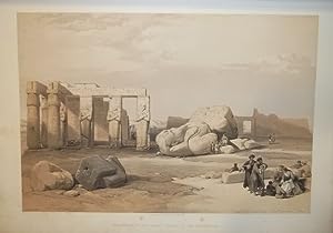
Egypt and Palestine. Photographed and Described. 2 Bände.
Edité par London, James S. Virtue, (1858-1859)., 1859
Vendeur : Versandantiquariat Wolfgang Friebes, Graz, Autriche
Membre d'association : ILAB VDAO
Evaluation du vendeur :

Edition originale Signé
Etat : 0. Erste Ausgabe dieses in 25 Lieferungen erschienenen frühen Fotografiewerks über den Nahen Osten. - Die Fotografien (ca. 14,5 x 16,5 bis 21,5 x 23 cm) tlw. in der Platte signiert u. in der Platte oder der gedruckten Legende meist 1857 datiert. Die Trägerkartons mit typographischer Bezeichnung. - Francis Frith (1822-1898) war der größte Verleger der Ansichtsfotografie seiner Zeit. Vor allem die Aufnahmen seiner drei Orientreisen (1856-1859) begründeten seinen Ruhm. - Francis Frith is undoubtetly one of the best-known photographers to work in the Near East. His trips to the Levant were a brilliant commercial success as well as an artistic one" (Perez). - Neben einem Porträt des Fotografen in orientalischer Tracht mit Aufnahmen aus Abu Simbel, Assuan, Baalbek, Bethlehem, Damaskus, Gizeh, Hebron, Jerusalem, Karnak, Luxor, Nazareth, Philae, Tiberias, Wadi Kardassy u.a. - Einbände etw. berieben u. bestoßen. Vordere Rückenkanten an den oberen Kapitalen etw. angebrochen, oberes Kapital des zweiten Bandes kaum merklich geklebt. Vorderdeckelbezug des ersten Bandes m. Fehlstellen. Vorsatzblätter m. Quetschfalten u. kl. Läsuren. Text schwach gebräunt bzw. fleckig, nur vereinzelt etw. stärker. Die Trägerkartons (bes. Ränder) wie meist unterschiedlich stockfleckig, die überwiegend sauberen Fotografien meist in schönen, kräftigen Abzügen. - Ibrahim-Hilmy I, 249; Travelers in Ancient Lands" S. 193; The Photobook I, 28; Gernsheim, History 286; Blackmer 1942; Hannavy 561; Perez, Focus East 165; Van Haaften/White XII u. XV. Sprache: Englisch Gewicht in Gramm: 10000 Gr.-Fol. (45 x 33 cm). Mit zus. 76 auf Untersatzkartons mont. Orig.-Fotografien (Albumin) von Francis Frith u. 82 nn. Bll. Text. HLdr.-Bde. d. Zt. m. goldgepr. Rückentiteln u. marmor. Schnitt.
-
Viaggio pittorico della Toscana.
Edité par Florenz, Tofani, 1801 - 1803., 1801
Vendeur : Matthaeus Truppe Antiquariat, Graz, Autriche
Membre d'association : ILAB VDAO
Evaluation du vendeur :
Livre Edition originale
3 Bde. VIII, 168; IV, 140; V, 140 S. 204 (4 doppelblattgr.) Aquatinta-Tafeln und 5 doppelblattgr. Kupferstichkarten. Erste Ausgabe dieses schönen und seltenen Ansichtenwerks der Toskana mit den gesuchten Aquatintatafeln von Giovanni Pera nach Antonio Terreni. - Brunet II, 1330. Feltrinelli III, 286: "The plates include a mixture of exterior and interior views, the former almost exclusively after Terreni. Little appears to be known of Terreni, but it seems likely that he is related to Giuseppe Maria Terreni (1739-1811), a native of Livorno, who worked in Florence and established a reputation as a vedutista". - "La lettera dedicatoria č sottoscritta dai fratelli Terreni, che fecero quel viaggio, disegnarono le vedute e le incisero assieme ad altri incisori, fra cui: Vincenzo Soinazzi, Giuseppe Pera, Cosimo Rossi, Giuseppe Politi, Carlo Cecchi e Matteo Carboni. Č una fra le piů importanti ed omogenee raccolte di luoghi toscani oggi quasi del tutto cambiati e documento storico di indiscusso valore. Le vedute, alcune a dopppia pagina, sono fra le piů belle del genere. Le 209 incisioni comprendono: 1 carta coreografica della Toscana, 9 piante (4 cititŕ: Firenze, Pisa, Livorno, Siena; 5 edifici fiorentini e 199 vedute dei piů svariati paesi e ecittŕ della Toscana" (www.gonnelli.it zum Nachdruck von 1972). Leicht gebräunt und fleckig. Buchblöcke leicht angebrochen. Exlibris *** *** Copyright: Matthaeus TRUPPE Buchhandlung & Antiquariat - Stubenberggasse 7 - A-8010 Graz - ++43 (0)316 - 829552 *** *** Sprache: Deutsch Gewicht in Gramm: 0 Gr.-Fol. Pp. der Zeit (beschabt und bestoßen) mit eingebundenem vorderen OU.
-
Voyage pittoresque en Autriche. - (Und:) Précis historique de la guerre entre la France et l Autriche en 1809.
Edité par Paris, Didot, 1821 - 1822., 1821
Vendeur : Matthaeus Truppe Antiquariat, Graz, Autriche
Membre d'association : ILAB VDAO
Evaluation du vendeur :
Livre Edition originale
3 Bde. 2 Bll., IV, 220 S., 1 Bl.; 2 Bll., IV, 106 S.; 3 Bll., 156 S. mit 3 Titelvignette und 27 Textabb. (alles in Aquatinta). 156 Aquatintas auf 116 Tafeln und 3 doppelblattgroße Kupferstichkarten. Erste Ausgabe des wohl schönsten topographischen Werkes über Österreich aus dem 19. Jahrhundert, mit dem oft fehlenden 3. Band über die napoleonischen Kriege in Österreich. - Nebehay/W. 348 u. 349. - Das Werk erschien in der vorliegenden nichtkolorierten Ausgabe und in einer kolorierten Luxusausgabe auf Velin-Papier. - "Das prächtige dreibändige Werk gilt als erstes großes illustriertes Kompendium, das die Schönheiten der österreichischen Landschaft international vorstellte. Graf Laborde war Archäologe, Schriftsteller und Diplomat und kam 1809 im Gefolge Napoleons nach Wien. Nachdem er zum Wiener Kongreß wieder nach Österreich kam, besuchte er Jakob Gauermann in Miesenbach, um ihn als Hauptmitarbeiter für das geplante Werk zu gewinnen. Gauermann weigerte sich zwar, mit Laborde nach Paris zu gehen, malte aber im Gebiet um Schneeberg und Gutenstein Arbeitsszenen der Waldbauern. Die meisten Stiche stammen von Benedikt Piringer, einem Meister der Aquatinta-Technik. Piringer ging dann mit Laborde nach Paris und kam zu hohen Ehren. Labordes Text vergleicht immer wieder die Schweiz mit den österreichischen Alpen. Dabei bemängelt der Franzose das mangelnde österreichische Bewußtsein für eigene Schönheit." (Wolfgang Kos). - Neben der literarischen Beschreibung der niederösterreichischen Landschaft und des napoleonischen Krieges zwischen Österreich und Frankreich ist das Werk aufgrund der bereits erwähnten prachtvollen Ansichten von Baden, Kaiserebersdorf, Heiligenkreuz, Klosterneuburg, Laxenburg, Lobau, Schönbrunn, Schneeberg, Deutsch-Wagram, Wiener Neustadt, Wien usw. sehr gesucht. Die Tafeln wurden nach Entwürfen von Isabey, Janscha, Gauermann, Moreau, Schütz usw. von Piringer, Schwarz u. a. gestochen. - Schönes breitrandiges Exemplar, teils stockfleckig. Die ersten Bll. von Bd. 1 mit braunem Wasserfleck im weißen Rand. Unbeschnitten. *** *** Copyright: Matthaeus TRUPPE Buchhandlung & Antiquariat - Stubenberggasse 7 - A-8010 Graz - ++43 (0)316 - 829552 *** *** Sprache: Deutsch Gewicht in Gramm: 0 Gr.-Fol. Grünes HLdr. des 19. Jahrhunderts mit roten Rückenschildern (berieben und etw. bestoßen).
-
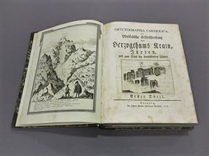
Bequemer Schul- und Reisen-Atlas. Aller zu Erlernung der Alten, MIttlern und Neuen Geographie dienlichen Universal- und Particular-Charten. Alles mit grossen Fleiß und Kosten ausgefertigt von Christoph Weigeln [Weigel].
Edité par Nürnberg, Johann Ernst Adelbulner,, 1719
Vendeur : Matthaeus Truppe Antiquariat, Graz, Autriche
Membre d'association : ILAB VDAO
Evaluation du vendeur :
Livre Edition originale
1 typograph. Titel, 1 Kupfertitel, 1 Privileg, 1 Kupfer-Inhaltsverzeichnis, 124 Kupferstichkarten bzw. Kupfertafeln und 6 typographische Erläuterungen (alles doppelblattgr. und zumeist altkoloriert). Zweite Ausgabe (die erste Ausgabe von 1718 ist nur in einem Exeemplar bekannt). - Bauer, Weigel 40. - "1718 erschien der erste, im Titelblatt datierte Atlas, den nun nach Fabers Tod Johann David Köhler herausgegeben hatte. Das Titelblatt des `Bequemen Schul- und Reisen-Atlas, wie der neue Titel des Werkes von nun an lautet, hebt besonders `die neue besondere Art` hervor, auf die die Karten von nun an illuminiert seien, ein Faktum auf das ja auch Hauber hingewiesen hatte. Diese Kolorierung betreffend hatte Köhler dem Atlas eine typographisch gedruckte Tafel vorangestellt, auf der er, nach einer kurze Einführung in die Geographie, die von ihm systematisch ausgearbeitete Illuminierung der ersten fünf Universal-Karten - das sind die Weltkarte sowie die Karten von Europa, Asien, Afrika und Amerika erläutert. Hierbei war eine Besonderheit, daß außer der Kennzeichnung der Grenzen der politischen Territorien und der Flächenkolorierung derselben durch die gleiche, aber stärker verdünnte Farbe, durch farbige Punktierungen Angaben über die Religion der Bevölkerung des jeweiligen Gebietes gemacht wurden" (Bauer Sp. 954). - Der sehr schöne Atlas enthält 124 Karten bzw. Tafeln, darunter sind viele der klassischen Karten wie die in Atlanten des frühen 18 Jahrhunderts gebräuchlich sind wie z. B. die Erdteilkarten, diverse Karten von Deutschland, Italien usw auch auch 6 schöne Himmelkarten, einige Wappenkarten sowie Erklärungen zum Festungsbau, dem Schiffsbau, Meilenanzeiger usw. Dazu gibt es noch interessante Karten von Louisanien in Nordamerika (mt einer typographischen Beschreibung) und zwei Karten der Antillen. Daneben einige Karten und Pläne die nach dem großen Türkenkrieg (1683 - 1699) zu erklären sind wie z. B. Plan von Belgrad, Plan der Umgebung von Belgrad, Grenzziehung des Friede von Karlowitz usw. Dazu dann auch noch Tafeln mit weiteren historischen Darstellungen wie z. B. Einzug des römischen Königs Joseph in Nürnberg, Abbildung des französischen Aktien-Handels, Abbildung der Papst-Wahl usw. Erwähnenswert sind auch noch die 3 gefalteten Tafeln zur Chronologie mit den beweglichen Teilen.- Laut Bauer fehlen folgende Nummern 27, 48, 50, 141, 142, 143, 144, 145, 146, 147, 149, 150, 151, 152, 153, 154, 155 und 156 (laut dem beigebundenen Kartenverzeichnis ist der Atlas aber komplett). - Alle Karten mit einer hs. Nummer. Etw. gebräunt und leicht fleckig. Vorsatz mit Spuren eines entfernten Besitzvermerkes (kl. Papierdurchbrüche). *** *** Copyright: Matthaeus TRUPPE Buchhandlung & Antiquariat - Stubenberggasse 7 - A-8010 Graz - ++43 (0)316 - 829552 *** *** Sprache: Deutsch Gewicht in Gramm: 4000 Fol. Ldr. der Zeit mit Rückenschild und Rückenvergoldung (etw. restauriert, Rücken mit Wurmspuren).
-
Die Unbekante Neue Welt, oder Beschreibung des Welt-teils Amerika, und des Sud-Landes: Darinnen vom Uhrsprunge der Ameriker und Sudländer, und von den gedenckwürdigen Reysen der Europer darnach zu. Wie auch Von derselben Festen Ländern, Inseln, Städten, Festungen, Dörfern . und so wohl alten als neuen Kriegen, ausführlich gehandelt wird; Durch und durch mit vielen nach dem Leben in Ameriken selbst entworfenen Abbildungen gezieret. Durch O(lfert) D(apper übersetzt).
Edité par Amsterdam, Meurs,, 1673
Vendeur : Matthaeus Truppe Antiquariat, Graz, Autriche
Membre d'association : ILAB VDAO
Evaluation du vendeur :
Livre Edition originale
3 Bll., 658 S., 11 Bll. mit ca. 70 Textkupfern. 1 Kupfertitel, 16 (1 gefalt.) Kupferkarten, 6 Kupfer-Porträts und 32 (meist gefalt. oder doppelblattgr.) Kupfertafeln. Erste deutsche Ausgabe. - VD17 3:307896S. Borba de Moraes I, 206f. Howes D 59. Tiele 763 Anm. Sabin 50087: ". much scarcer than the Dutch original". - "This is a classic book on America, and is much sought after by collectors of Americana as it contains one of the first views of New York during the Dutch period. It is searched for with no less eagerness by Brazilians for it is a classic on the Dutch period." (Borba de M. II, 77). - Arnold Montanus (auch Arnold van den Berghe; 1625 - 1683) war ein niederländischer Theologe und Historiker. Er verfasste zahlreiche historische Abhandlungen, die sich mit den Völkern und der Kultur der Neuen Welt und der Geschichte der Niederländer in Übersee befassen. Obwohl er selbst Europa nie verlassen hat, wurden seine Bücher zu Standardwerken, besonders "De Nieuwe en Onbekende Weereld" ist eine reiche Fundgrube zur Geschichte Amerikas des 16. und 17. Jahrhunderts. Die vorliegende erste deutsche Ausgabe dieses Werkes wurde vom niederländischen Arzt Olfert Dapper übersetzt und erweitert. - Die mindestens doppelblattgroßen Tafeln zeigen Ansichten der wichtigen Städte u. Häfen der Neuen Welt, darunter Acapulco, Bahia, Havanna, Neu Mexico, Lima, Potosi u. a., im Text meist Kostüme, Tiere u. Pflanzen sowie weitere Ansichten, darunter Neu-Amsterdam. - Unter den Karten Neu-Belgien mit Manhattan, Neu-Spanien (Mexiko), Venezuela, Brasilien u. Feuerland. - Die eindrucksvollen Porträts u. a. von Kolumbus, Montezuma, Magellan. Mit der öfters fehlenden großen Karte von Amerika. - Titel mit hinterlegter Fehlstelle. Die Tafel "Alagoa ad Austrum" (S. 494) mit kl. Fehlstellen durch Rasur auf der Hinterseite. Leicht gebräunt, kaum fleckig. Vereinzelt im unteren weißen Rand angerandet. *** *** Copyright: Matthaeus TRUPPE Buchhandlung & Antiquariat - Stubenberggasse 7 - A-8010 Graz - ++43 (0)316 - 829552 *** *** Sprache: Deutsch Gewicht in Gramm: 0 4°. Mod. Ldr. unter Verwendung von wenigen Resten des alten Rückens (leicht berieben).
-
Vues remarquables des montagnes de la Suisse.
Edité par (Amsterdam, Yntema, 1785)., 1785
Vendeur : Matthaeus Truppe Antiquariat, Graz, Autriche
Membre d'association : ILAB VDAO
Evaluation du vendeur :
Livre Edition originale
Titel in Aquatinta und 32 (statt 42 ?) Farbstiche (es fehlt der typographische Titel und der Text). Erste Ausgabe. - Gaesse III, 243. Cohen/De Ricci 485. - Eines der frühesten und seltensten Bücher mit Ansichten aus den Schweizer Alpen in Farbstich. Die Farbdrucke sind von höchster Qualität. Die Arbeit an der Serie wurde im Jahr 1779 vom Originalverleger, Wagner in Bern, begonnen, der wiederum Janinet mit den Kupfersticharbeiten in der damals neuen Technik des Farbdrucks beauftragte. Der Tod Wagners und Geldmangel ließen die Arbeit ins Stocken geraten. Die fertiggestellten 24 Tafeln wurden 1785 an Hentzy verkauft, der Descourtis 18 zusätzliche Tafeln in Auftrag gab. Als die Arbeit beendet war, hat Hentzy gerade als Schweizer Offizier in der holländischen Armee gedient. Also ließ er das vollendete Werk von J. Yntema in Amsterdam veröffentlichen. - Bibliographisch ist die Kollation etwas schwer zu ermitteln. Wir können ein Exemplar mit 42 Tafeln bei Sotheby s im Jahr 1988 (Auktion am 24. Juni - Nr. 280 - verkauft für BP 42.000) nachweisen, ein weiteres Exemplar mit 41 Tafeln befindet sich zur Zeit im Handel (19th Century Shop - Angeboten auf der Liber Berlin im Jahre 2002 für EURO 60.000.-), Cohen/De Ricci kennt nur Exemplare mit 40 Tafeln. Außerdem scheint noch ein Textband erschienen zu sein, dieser fehlt fast überall (meist werden 11 bzw. 12 Textblätter verzeichnet) vorhanden ist ein solcher aber auf der UB in Göttingen. - Auf dem Einband ist als Deckeltitel "A. Weustenraad, Album des principales vues de la Suisse" angegeben. - Eine Aufstellung der Tafeln und ihres Zustandes (teils bis in die Schrift beschnitten, leicht fleckig und gebräunt) ist auf Anfrage erhältlich. *** *** Copyright: Matthaeus TRUPPE Buchhandlung & Antiquariat - Stubenberggasse 7 - A-8010 Graz - ++43 (0)316 - 829552 *** *** Sprache: Deutsch Gewicht in Gramm: 2000 Quer-Fol. Ldr. des frühen 19. Jahrhunderts mit Deckeltitel, Rückenvergoldung sowie dreiseitigem Goldschnitt (beschabt und stärker bestoßen).
-
Neue Untersuchungen ueber die physicalische Geographie und die Geologie der Alpen. Textband und Atlas. Zus. 2 Bde.
Edité par Leipzig, T.O. Weigel, 1854,, 1854
Vendeur : Harteveld Rare Books Ltd., Fribourg, Suisse
Membre d'association : ILAB VEBUKU
Evaluation du vendeur :
Edition originale
imp.-Fol. (55 x 39 cm) und in-4to, XVI + 639 S. + 1 Falttab. / 2 Bl. (Titel, und Verzeichnis der Tafeln) + 22 meist farbige lithograph. Tafeln davon 3 doppelblattgr. + 8 Umrisstafeln (zu Tafel 7-9, 11-14, und 20) + 8 Bl., teils stockfleckig, Textband in Original-Broschur & Tafelband. Tafeln lose eingelegt in Original-Umschlag (dieser etwas gebraucht und mit kl. Randeinrissen). Erste Ausgabe des sehr seltenen und sehr gesuchten Standardwerkes mit den grossartigen Ansichten und Panoramen in einem wohlerhaltenen Gesamtexemplar. Textband und Atlas mit insges. 30 Tafeln: 22 teils getönte und kolorierte Lithographien, meist prachtvolle Gebirgspanoramen, davon 3 doppelblattgross: Karte des Monte-Rosa und seiner Umgebung (Lith. Anstalt Kraats Berlin) / Ansicht des Monte-Rosa und des Gorner Gletschers (lithogr. v. A. Haun) / Vergleichende Darstellung der physikalischen Verhältnisse der Alpen; dazu 4 Karten-Tafeln, 4 Tafeln mit Profilen und einigen Instrumenten, 3 Tabellen-Tafeln, und 8 Erläuterungsblätter der landschaftlichen Ansichten. ?Das Werk behandelt weitgehend die Schweizer Alpen, mit Darstellungen vor allem aus dem Wallis (Monte-Rosa), dem Berner Oberland, doch auch aus Ober-Bayern. Die topographische Karte des Monte-Rosa (Tafel 1), wurde von Herrn H. Lange mit vorzüglicher Sorgfalt in einem Blatte gezeichnet .? (Vorwort zum Textband). Zum Zweck wissenschaftlicher Untersuchungen und Messungen hatten die Brüder Adolf & Hermann Schlagintweit, von denen einer später auf einer Expedition in Indien auf tragische Art und Weise von erbosten Einheimischen enthauptet wurde, 1851 die zweite Ersteigung des Grenzgipfels Monte-Rosa ausgeführt und damit als erste Touristen überhaupt diese Region betreten. Im gleichen Jahr erreichten sie auch die Vincentpyramide und überschritten erstmals das Fillarjoch in der Weisstorkette. Die Brüder waren die ersten deutschen Forscher, die in den Westalpen hochtouristisch hervortraten. Durch ihre gründlichen Untersuchungen haben sie sich in ihren Bemühungen um eine vollständige Erforschung des Monte-Rosa-Stockes hohes Verdienst erworben. Das Ergebnis ihrer wissenschaftlichen und touristischen Tätigkeit in den Schweizer Alpen ist in ihrem das Gesamtgebiet der Alpen umfassenden grossartigen Werk ?Neue Untersuchungen, etc.? niedergelegt. Im folgenden ein auszugsweises Verzeichnis einiger der prachtvollen lithographischen Ansichten:Ansicht des Monte-Rosa und des Gorner-Gletschers,Ansicht des Alpenzuges vom Monte-Cervin bis zum Mettelhorn,Das untere Ende des Gornergletschers,Ansicht der Vincentpyramide,Die oberste Felsenkuppe des Monte-Rosa,Die Vincenthütte am Col delle Piscie,Ansicht des Monte-Rosa und der Lyss-Kamm,Vergleichende Darstellung der physikalischen Verhältnisse der Alpen, etc. etc. Please notify before visiting to see a book. Prices are excl. VAT/TVA (only Switzerland) & postage. BMC (nat. Hist.) IV, 1837; Lehner, Eroberung der Alpen, pp. 341 ff.; Graf BSL II/51; Perret 3951, Wäber 82 & 218; Interlibrum Katalog 314: Berühmte Schweizer Forscher (1987); Dreyer 251; Poggendorff I, 802.
-
Description générale et particuličre de la France [volumes I-IV] Voyage pittoresque de la France [volumes V-XII].
Edité par Paris, Ph. D. Pierres et Imprimerie de Monsieur pour Lamy, 1781-[1799/1800]. 1781, 1800
Vendeur : JF LETENNEUR LIVRES RARES, Saint Briac sur mer, France
Membre d'association : ILAB
Evaluation du vendeur :
Edition originale Signé
6 vol. In-folio subdivisés en 12 tomes (491 x 321 mm): I.T1. [3] ff. (f.t., t. , dédicace), XX pp. (préface), 216 pp ; T2. [2] ff. (f.t., t.), p. 217 ŕ p. 535 ; II. T3. [2] ff. (f.t., t.), xxiv pp. (discours), 254 pp. (20 planche sur 10 feuilles) ; T4. [2] ff. (f.t. , t.), 240 pp. ; III. T5. [2] ff. (f.t. , t.), 104 pp. et 29 gravures sur 17 feuilles + 1 tableau généalogique dépliant + 1 plan sur double page, [1] ff. (t. Comté de Foix), 56 pp., [1] ff. et 7 gravures sur 4 feuilles ; T6. [1] ff. (t. Introduction), XXV pp., 173 pp., [5] pp. (table et approbation) et 66 gravures sur 44 feuilles ; IV. T7. [3] ff. (ft., t.g. Dauphiné, prospectus), [8] ff. , 6 pp. , [8] ff. , 6 pp. , [4] ff. , 3 pp. et 124 gravures sur 88 feuilles ; T8. , [2] ff. (f.t. , t), [2] ff. , 4 pp., [18] ff. , 4 pp., 173 gravures sur 89 feuilles ; V. T9. , [2] ff. (f.t. , t.), 64 pp. , 8 pp. , 6 pp. , 11 pp. , 4 pp. , 4 pp. , 4 pp. , 6 pp. , 4 pp. , 4 pp. , 4 pp. , et 72 gravures sur 49 feuilles ; T10. , [2] ff. (ft , tg.), 4 pp. , 3 pp. , 3 pp. , 3 pp. , 3 pp. , 4 pp. , 3 pp. , 3 pp. , 4 pp. , 3 pp. , 4 pp. , 3 pp. , et 133 gravures sur 78 ; VI, T11.,[1] ff (tg), 3 pp. , 3 pp. , 3 pp. , 3 pp. , 3 pp. , 3 pp. , 3 pp. , 3 pp. , 74 gravures sur 44 feuilles ; T12. [1] ff. (tg.), 3 pp., 3 pp., 2 pp. , 3 pp. , 2 pp. , et 33 gravures sur 24 feuilles ; [1] ff (t.g.), 2 pp. , 3 pp. , 3 pp. , 2 pp. , [1] ff. , 3 pp. (table de toutes les pičces et parties), et 34 gravures sur 22 feuilles. Soit un total de plus de 760 gravures, avec de une ŕ 8 gravures par pleine page et des gravures sur double et triple page ainsi que 1 table généalogique dépliante. Plein veau d'époque, dos lisses ornés, frise dorée encadrant les plats, tranches dorées. (mors, coins, coiffes discrčtement restaurés). Édition originale de cette description colossale de la France due ŕ Jean-Benjamin de La Borde (1734-1794), compositeur, historien, mécčne et fermier général français qui fut le premier valet de chambre du Roi Louis XV. Cette trčs ambitieuse Description de la France se veut ętre particuličrement complčte en abordant l'histoire des m urs et des coutumes du peuple français, la géographie ainsi que l'histoire naturelle des différentes régions françaises. Toutefois, seuls les quatre premiers volumes ont pu ętre réalisés dans cet esprit. En effet, de part la démesure du projet qui s étalera sur prčs de 20 ans (1781-1800), Laborde rencontre des problčmes tant au niveau financier (parrainages) qu au niveau de la faisabilité globale d une telle entreprise. Pourtant, il jouit de trčs bonnes relations avec de nombreux graveurs et dispose d une excellente manne financičre étant le fils du banquier et fermier général Jean-François de La Borde, baron de La Brosse. A ces obstacles s ajoute le contexte politique révolutionnaire qui n arrange pas ses affaires en tant que monarchiste. Cette position et sa grande proximité avec la monarchie lui vaudront d ętre guillotiné ŕ Paris le 22 juillet 1794, l empęchant de voir l aboutissement de son travail. C est pourquoi, passé le quatričme volume, les suivants sont malheureusement écourtés. En effet, si les illustrations se font de plus en plus présentes, les descriptions textuelles sont quand ŕ elles de moins en moins fournies ŕ mesure de l avancement des volumes. Malgré ces déconvenues, La Borde parvient tout de męme ŕ dresser le panorama de la France le plus complet de l époque incluant de nombreux paysages, lieux, villes et monuments mais aussi parfois des scčnes historiques comme cette extraordinaire planche de Moreau Le Jeune gravée par Malbeste, Lienard et Née représentant une «Vue de la plaine des sablons ou se faisoit ci-devant la revue des Gardes françoises et des Gardes Suisses» ou encore la «Revue de la Maison du Roi, au trou d'Enfer» dessinée par Le Paön et gravée par Le Bas. Ainsi, l ouvrage couvre la quasi totalité des régions française: Auvergne, Bourgogne, Champagne, Corse, Dauphiné, Franche-Comté, Guyenne, Ile-de-France, Languedoc, Lyonnais, Normandie, Pays de Gex, Paris et ses environs, Picardie, Provence et Roussillon. Ce travail, bien qu issu de l ancien régime, est nettement plus ambitieux que ses prédécesseurs. Si La Borde ne cache rien de son attachement ŕ la monarchie et ŕ son Roi, son ambition n est pas de flatter l égo de ce dernier mais plutôt de mettre ŕ l honneur les nombreuses richesses de la France et de son peuple, tant sur le plan historique que culturel. Ainsi, bien que les objectifs de ce projet titanesque ne furent pas totalement atteint, ce travail de La Borde fait figure de modčle pour les publications ultérieures dont la Description de l Égypte (1821-1830). Bel exemplaire de cette impressionnante description de la France bien conservée dans sa reliure d époque. 6 vol. In-folio divided into 12 volumes (491 x 321 mm) : I.T1. [3] ff. (half-title, title, dedication), XX pp. (preface), 216 pp; T2. [2] ff. (half-title, title), pp. 217 to p. 535; II. T3. [2] ff. (half-title, title), xxiv pp. (speech), 254 pp. (20 plates on 10 leaves); T4. [2] ff. (half-title, title), 240 pp. ; III. T5. [2] ff. (half-title, title), 104 pp. and 29 engravings on 17 leaves + 1 folding genealogical table + 1 plan on double page, [1] ff. (t. Comté de Foix), 56 pp. and [1] ff. and 7 engravings on 4 leaves ; T6. [1] ff. (title, Introduction), XXV pp, 173 pp, [5] pp (table and approval) and 66 engravings on 44 leaves; IV. T7. [3] ff. (half-title, title, Dauphiné, prospectus), [8] ff. , 6 pp. , [8] ff. , 6 pp. , [4] ff. 3 pp. and 124 engravings on 88 leaves; T8. 2] ff. (half-title, title), [2] ff. 4 pp. and [18] ff. 4 pp. 173 engravings on 89 leaves ; V. T9. V., [2] ff. (half-title, title), 64 pp. , 8 pp. , 6 pp. , 11 pp. , 4 pp. , 4 pp. , 4 pp. , 6 pp. , 4 pp. , 4 pp. , 4 pp. and 72 engravings on 49 leaves; T10. 2] ff. (half-title, title), 4 pp. , 3 pp. , 3 pp. , 3 pp. , 3 pp. , 4 pp. , 3 pp. , 3 pp. , 4 pp. , 3 pp. , 4 pp. , 3 pp. and 133 engravings on 78; VI, T11, [1] ff (title), 3 pp. , 3 pp. , 3 pp. , 3 pp. , 3 p.
-
Die Ehre Deß Hertzogthums Crain: Das ist . Belegen- und Beschaffenheit dieses . Römisch-Kayserlichen Erblandes. . In reines Teutsch gebracht . und erweitert durch Erasmus Francisci.
Edité par Laibach und Nürnberg, Endter,, 1689
Vendeur : Matthaeus Truppe Antiquariat, Graz, Autriche
Membre d'association : ILAB VDAO
Evaluation du vendeur :
Livre Edition originale
4 Bde. Mit über 500 Textkupfern. 1 Frontisp., 1 Porträt, 4 doppelblattgr. Karten und 18 (davon 1 vierblattgr. und 11 doppelblattgr.) Tafeln (alles in Kupferstich) sowie 1 doppelblattgr. Tabelle. Erste Ausgabe des wichtigsten Werkes zur krainerischen bzw. slowenischen Geschichte und Topographie. - VD17 23:266828Z. Nebehay/W. 766. - Johann Weichard von Valvasor (slowen. Janez Vajkard Valvasor; 1641 - 1693) besuchte die jesuitische Lateinschule in Laibach, nahm am Türkenfeldzug 1663/64 teil und bereiste längere Zeit Frankreich, Italien und Afrika. Auf Schloß Wagensberg, wo er seit 1672 lebte, sammelte er Bücher, Graphiken, Münzen und Instrumente und eröffnete 1678 eine Kupferstecherei. Als Viertelhauptmann führte er 1683 krainische Truppen gegen die Türken. 1687 wurde Valvasor in die Royal Society aufgenommen. Als Buchkünstler schuf er zusammen mit anderen ein Bildbuch zur Passion Christi (Dominicae passionis icones, 1679) und ein "Theatrum mortis humanae (3 Tle., 1682)". "Baron Johann Weichert Valvasor realised his country was very little known abroad, and he set out to present it in words and pictures, writing descriptions of Carniola, Carinthia and Istria, and setting up a copper engraving and printing workshop at Bogensperk . Here he wrote two of his most famous works in 1679 the "Topographia ductatus Carniolae modernae", an album of 320 engravings of towns, market towns, monasteries and castles in Carniola, with an index in both German and Slovenian. The second was The Glory [in Praise] of the Duchy of Carniola (Die Ehre dess Hertzogthums Crain) originally written in German and published in Nuremberg in 1689. This was the first systematic overview of the history, territory and way of life of Carniola and nearby regions". (royalsociety-org). - Ein großer Teil der Ansichten wurde dem 1679 erschienen Werk Valvasor "Topographia Ducatus Carniolae modernae" übernommen, jedoch zumeist dem Hochformat neu angepaßt, indem die Platten seitlich verkleinert wurden. Andere Kupferplatten wurden aber neu gestochen. Die neuen Platten sind feiner und haben keine zweisprachige Beschriftung. Neben den topographischen Ansichten weist das Werk auch Landkarten und zahlreiche historische kostumkundliche und folkloristische Darstellungen auf. - Es fehlt die S. 1/2 (Titel) in Bd. 2. - Etw. gebräunt und fleckig. Wenige kl. teils hinterlegte Randläsuren (meist ohne Textberührung). Die doppelblattgr. tafeln teils mit Randeinrissen (teils geringer Verlust). *** *** Copyright: Matthaeus TRUPPE Buchhandlung & Antiquariat - Stubenberggasse 7 - A-8010 Graz - ++43 (0)316 - 829552 *** *** Sprache: Deutsch Gewicht in Gramm: 10200 4°. Pgmt. der Zeit (etw. bestoßen und fleckig).
-
De natura locoru(m). Libru(m) mira eruditio(n)e & singulari fruge refertu(m), & iam primu(m) summa diligentia revisum, in lucem aeditum, quem leges diligentius, si vel cosmographia vel phisica profecisse te volueris.
Edité par (Am Ende:) Wien, H. Vietor und J. Singriener für L. & L. Alantsee,, 1514
Vendeur : Matthaeus Truppe Antiquariat, Graz, Autriche
Membre d'association : ILAB VDAO
Evaluation du vendeur :
Livre Edition originale
52 nn. Bll. mit Holzschnitt-Titelbordüre und einem ganzseit. Wappenholzschnitt Kaiser Maximilians I. (auf dem letzten Bl.). Erste Ausgabe von dem Wiener Mathematiker und Astronomen Georg Tannstetter, gen. Collimitius (1482 - 1535), herausgegeben, selten. - VD16, A 1345. Sabin: 671: "Interesting to the American collector an account of marginal note relating to Vespuccius, which seems to have insert with moveable type, on the recto of the last leaf in signature e [hier d], after the book had been printed". - "The printed editions of De Natura Locorum are particularly interesting in that they include a contemporary reference to Amerigo Vespucci and his voyages. Where Albertus wrote that the Southern hemisphere is habitable, the sixteenth century editor added: `Behold he concludes that it is habitable at 50ş beyond the equator, as Vespucci has discovered and described by his voyages in previous years`." (library udel edu). - Für die Geschichte und Entwicklung der Geographie überaus bedeutende Schrift, vermutlich zwischen 1270 und 1280 in Köln entstanden. "Albert markiert darin die Anfänge der naturwissenschaftlichen Geographie als einer selbständigen Disziplin, die über die rein beschreibende Länderkunde durch enge Verbindungen mit Physik, Astronomie, Mathematik, Biologie und Geologie hinausgeht. Die Interferenzen, insbesondere zwischen Geographie einerseits und Biologie, Geologie sowie Physik andererseits, haben bei den arabischen Autoren schon Vorläufer, wenn auch direkte Verbindungen zu Europa derzeit kaum im einzelnen nachweisbar sind. Die Beziehungen zwischen Astronomie und Mathematik einerseits und Geographie andererseits, die zur modernen Kartographie führen, kann Albert so jedoch nicht in arabischen Schriften gefunden haben. . Mit Sicherheit ist Albert der erste, der sie wissenschaftlich begründet und versucht hat, die neue Geographie in das von seinem Schüler Thomas von Aquin entworfene Wissenschaftssystem einzugliedern. . Albert hat sich mit durchaus adäquaten Mitteln bemüht, auf die Brisanz der (Bedeutung der geographischen Koordinaten) hinzuweisen. Nicht nur durch den bereits zitierten ersten Titel (de natura loci ex latitudine) führte er zum Zentrum des Gegenstandes, sondern das ganze Buch ist ihm strikt untergeordnet. Es ist in drei Traktate gegliedert. Der erste betrifft die Länge und Breite eines Ortes, wie sie von der Entfernung vom Himmelsgewölbe abgeleitet sind. . Es kann kein Zweifel bestehen, daß Albert im Titel seines Liber de natura loci ex latitudine . von Längen und Breiten im Sinn geographischer Koordinaten sprach. Ganz eindeutig argumentiert er immer wieder mit Bezug des Ortes zum Himmel, zu den Sternen, zu den Planeten, was die Schrift bei der ersten flüchtigen Lektüre in eine unvermutete Nähe zur Astrologie rückt. Aber bei genauerem Hinsehen verschieben sich die Akzente etwas. Mit der astrologischen Argumentationsweise befindet sich Albert einerseits in einem, seinen Zeitgenossen verständlichen und zugänglichen Bereich, der in einer jahrtausendelangen, alle Kulturen übergreifenden Tradition steht. . Die dann folgenden Kapitel des I. und II. Traktates sind der Entwurf einer physischen Geographie. Sie hängt eng zusammen mit Alberts astronomischen, physikalischen, mineralogischen und biologischen Schriften und beruht, besonders in den letzten beiden Bereichen, vielfach auf eigenen Beobachtungen. Die modern anmutende Frage etwa, ob und wie die Erde von der Kugelgestalt abweicht, wird von Albert (übrigens wie wenig später auch von Dante) nicht eindeutig beantwortet, sondern sie wird nur als die Meinung der alii wiedergegeben, die glauben, daß die Landmassen auf der nördlichen Halbkugel aus der Kugel herausragen, ihr also eine birnenähnliche Gestalt geben. Die Ausbeutelung der Birne glaubte übrigens Kolumbus, der Albert gelesen hatte, in Südamerika dort gefunden zu haben, wo der Orinoco herkam, dessen starke Strömung an der Mündung er sich nicht anders erklären konnte, als durch das Gefälle an einem sehr hohen Berg" (Uta Lindgren, Albertus Magnus und die Geographie als scientia naturalis. In: Archives internationales d`histoire des sciences, Bd. XLIV, 1994, S. 3 ff.). - Leicht gebräunt und nur vereinzelt leicht fleckig oder wasserrandig. Teils kleinere zeitgenössische Randnotizen oder Anstreichungen. Mehrere durchgängige Wurmgänge, gegen Ende zahlreiche (ohne Textverlust). *** *** Copyright: Matthaeus TRUPPE Buchhandlung & Antiquariat - Stubenberggasse 7 - A-8010 Graz - ++43 (0)316 - 829552 *** *** Sprache: Deutsch Gewicht in Gramm: 500 8°. Mod. HPgmt. unter Verwendung von Material des 18. Jahrhunderts.
-
Oryctographia Carniolica, oder Physikalische Erdbeschreibung des Herzogthums Krain, Istrien und zum Theil der benachbarten Länder. 4 in 1 Bd.
Edité par Leipzig, Breitkopf, 1778 - 1789., 1778
Vendeur : Matthaeus Truppe Antiquariat, Graz, Autriche
Membre d'association : ILAB VDAO
Evaluation du vendeur :
Livre Edition originale
XVI, 162 S., 1 Bl. (Verbesserungen), XXXII, 186 S., 1 Bl. (Zusatz zu S. 152), XX, 184 S., XVI, 91 S. mit einigen Textkupfern. 4 Frontisp., 3 mehrfach gefalt. Landkarten und 19 gefalt. Tafeln (alles in Kupferstich). Erste Ausgabe, so komplett und selten. - Holzmann/B. III, 7953. ÖBL II, 133 f. Poggendorff I, 986. Minrec: "Rare. A heavily illustrated work, describing the geology, paleontology and mineral riches of Istria (now ??????) where the author lived a number of years.". - "Oryctographia Carniolica (Carniolan Mineralogy; with the subtitle oder Physikalische Erdbeschreibung des Herzogthums Krain, Istrien, und zum Theil der benachbarten Länder `or a Physical Geography of the Duchy of Carniola, Istria, and in Part the Neighboring Lands`) is a four-volume work by Belsazar Hacquet, published in Leipzig in 1778, 1781, 1784, and 1789. It discusses the physical properties of the Duchy of Carniola, Istria, and parts of the neighboring lands. It also includes an in-depth description of the Idrija mercury mine. The front page of the work presents the first known depiction of Triglav, the highest mountain in Slovenia. The copper engraving was produced by C. Conti after a drawing by Franz Xaver Baraga" (Wikipedia Abruf vom 18.09.2023). - "His most important work `Oryctographia carniolica or Physical (=geological) description of Carniola` contains descriptions of rocks, ores, fossils, as well as surface and underground features. In Carniola, karst is prevailing and therefore there is a lengthy description of karst geology and geomorphology included. His classification of mountains specially mentions Montes secundarii formed by grey limestone. Of surface features dolines, glacio-karstic dolines on high plateaus (with temperature and vegetation inversion), and karst poljes are mentioned. Hacquet presumed the evolution from flooded polje (seasonal lake) to a dry one. To explain the weathering and dissolution of limestone Hacquet took into account the differences between the rock, the exposition and its element content. That is the reason why Gams regarded him as a precursor of a climatic geomorphology and the "father" of corrosion theory. Hacquet has also found the difference between limestone and dolomite. His description of dolomite as Lapis suillus preceded the one of D. Dolomieu for 13 years. Hacquet`s statements were not based on observation only, but on the experiment too. When looking upon Hacquet`s explanations and results we must not forget that Hacquet`s time was still time of parapathetic logic, of four elements and of the principle of burning - the flogiston" (Andrej Kranjc, Baltazar Hacquet (1739/40-1815), the Pioneer of Karst Geomorphologists). - Die große Landkarte "Mappa Litho-Hydrographica Nationis Slavicae" liegt lose bei. - Leicht gebräunt und fleckig. *** *** Copyright: Matthaeus TRUPPE Buchhandlung & Antiquariat - Stubenberggasse 7 - A-8010 Graz - ++43 (0)316 - 829552 *** *** Sprache: Deutsch Gewicht in Gramm: 0 Gr.-8°. HLdr. der Zeit mit Rückentitel (etw. berieben und bestoßen).
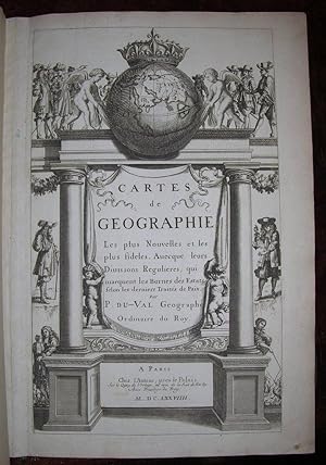

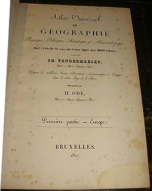
![Image du vendeur pour De triangulis planis et sphaericis. (.) quae extructa est ŕ Ptolemeaeo & Copernico de Revolutionibus orbium caelestium. [Avec : ] - Problematum astronomicorum et geometricorum sectiones septem. [Avec :] - In Ptolemaei magnam compositionem, quam almagestum vocant, libri tredecim mis en vente par Hugues de Latude](https://pictures.abebooks.com/inventory/md/md30050208247.jpg)

![Image du vendeur pour Geographischer und Physischer Atlas von Neu-Spanien. gegründet auf astronom: trigonom: und Barometer Messunden [old ink mss.]. mis en vente par Altea Antique Maps](https://pictures.abebooks.com/inventory/md/md31449501850.jpg)
![Image du vendeur pour I. Geographiae libri octo, recognitiam diligenter. [II. Galliae Tabule Geographicae. Belgii Inferiores Geographicae Tabule]. mis en vente par JF LETENNEUR LIVRES RARES](https://pictures.abebooks.com/inventory/md/md22846645099.jpg)
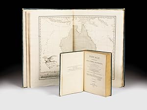
![Image du vendeur pour Cosmographia [with:] De situ orbis mis en vente par Donald A. Heald Rare Books (ABAA)](https://pictures.abebooks.com/inventory/md/md31814926085.jpg)
![Image du vendeur pour Bequemer Schul- und Reisen-Atlas. Aller zu Erlernung der Alten, MIttlern und Neuen Geographie dienlichen Universal- und Particular-Charten. Alles mit grossen Fleiß und Kosten ausgefertigt von Christoph Weigeln [Weigel]. mis en vente par Matthaeus Truppe Antiquariat](https://pictures.abebooks.com/inventory/md/md20480671394.jpg)