Montant total (1 article articles) :
Destination de la commande :

account expeditions sources mississippi western de pike (20 résultats)
Passer aux résultats principaux de la recherche
Type d'article
- Tous les types d'articles
- Livres (19)
- Magazines & Périodiques
- Bandes dessinées
- Partitions de musique
- Art, Affiches et Gravures
- Photographies
- Cartes (1)
-
Manuscrits &
Papiers anciens
Etat
Reliure
Particularités
Pays
Evaluation du vendeur
-

An Account of Expeditions to the sources of the Mississippi and through the Western parts of Louisiana, to the sources of the Arkansaw, Kans, La . of the U.S., during 1805-1807; - Scholar's
Edité par Scholar's Choice, 2015
ISBN 10 : 1298025338ISBN 13 : 9781298025333
Livre
Etat : New.
Plus de choix d'achat de la part d'autres vendeurs sur AbeBooks
Offres neuf ŕ partir de EUR 34,51
-
![Image du vendeur pour An account of expeditions to the sources of the Mississippi, and through the western parts of Louisiana, to the sources of the Arkansaw, Kans, La Platte, and Pierre Jaun, rivers performed by order of the government of the United States during the years 1805, 1806, and 1807 : and a tour through the interior parts of New Spain . / by Major Z.M. Pike (1810) [Leatherbound] mis en vente par S N Books World](https://pictures.abebooks.com/inventory/md/md30637419367.jpg)
An account of expeditions to the sources of the Mississippi, and through the western parts of Louisiana, to the sources of the Arkansaw, Kans, La Platte, and Pierre Jaun, rivers performed by order of the government of the United States during the years 1805, 1806, and 1807 : and a tour through the interior parts of New Spain . / by Major Z.M. Pike (1810) [Leatherbound]
Date d'édition : 2022
Livre impression ŕ la demande
Leatherbound. Etat : NEW. Leatherbound edition. Condition: New. Leather Binding on Spine and Corners with Golden leaf printing on spine. Bound in genuine leather with Satin ribbon page markers and Spine with raised gilt bands. A perfect gift for your loved ones. Reprinted from 1810 edition. NO changes have been made to the original text. This is NOT a retyped or an ocr'd reprint. Illustrations, Index, if any, are included in black and white. Each page is checked manually before printing. As this print on demand book is reprinted from a very old book, there could be some missing or flawed pages, but we always try to make the book as complete as possible. Fold-outs, if any, are not part of the book. If the original book was published in multiple volumes then this reprint is of only one volume, not the whole set. IF YOU WISH TO ORDER PARTICULAR VOLUME OR ALL THE VOLUMES YOU CAN CONTACT US. Resized as per current standards. Sewing binding for longer life, where the book block is actually sewn (smythe sewn/section sewn) with thread before binding which results in a more durable type of binding. Pages: 529 Language: English Pages: 529.
-
![Image du vendeur pour An account of expeditions to the sources of the Mississippi, and through the western parts of Louisiana, to the sources of the Arkansas, Kans, La Platte, and Pierre Juan, Rivers. Performed by order of the Government of the United Statos during the years 1805, 1806, and 1807, and a tour through the interior parts of New Spain, when conducted through these provinces, by order of the captain-general in the year 1807, by Major Z.M. Pike [ Great Americac series] [map1 [Falls of St. Anthony] -- map2 The first part of Capt'n Pike's chart of the internal part of Louisiana -- map3 A chart of the internal part of Louisiana -- map4 A map of the Internal Provinces of New Spain -- map5 A sketch of the Vice Royalty . -- map6 Map of the Mississippi Rive mis en vente par Joseph Valles - Books](https://pictures.abebooks.com/inventory/md/md22479506735.jpg)
An account of expeditions to the sources of the Mississippi, and through the western parts of Louisiana, to the sources of the Arkansas, Kans, La Platte, and Pierre Juan, Rivers. Performed by order of the Government of the United Statos during the years 1805, 1806, and 1807, and a tour through the interior parts of New Spain, when conducted through these provinces, by order of the captain-general in the year 1807, by Major Z.M. Pike [ Great Americac series] [map1 [Falls of St. Anthony] -- map2 The first part of Capt'n Pike's chart of the internal part of Louisiana -- map3 A chart of the internal part of Louisiana -- map4 A map of the Internal Provinces of New Spain -- map5 A sketch of the Vice Royalty . -- map6 Map of the Mississippi Rive
Edité par New York : Readex Microprint, [Philadelphia, Published by C. & A. Conrad & Co. . etc., 1810.], 1966, 1966
Vendeur : Joseph Valles - Books, Stockbridge, GA, Etats-Unis
Evaluation du vendeur :

Hardcover. Etat : Fine. No Jacket. 1 volume (various pagings) maps (2 folded) portrait 22 cm. ; similar to: OCLC: 961382 ; LCCN: 66-26328 ; LC: F592; E31; Dewey: 917.8042 ; red textured faux leather ; no dustjacket ; Even before Lewis and Clark had returned in 1806, Lieutenant Zebulon Pike was sent to explore the southern reaches of the Louisiana Territory. Pike traveled to Colorado and down the Front Range looking for the Red River. His party failed to find it and instead wandered into New Mexico where the Spanish caught him and escorted him home. His expedition returned with valuable information about the northern provinces of colonial Mexico. ; Contents: map1 [Falls of St. Anthony] -- map2 The first part of Capt'n Pike's chart of the internal part of Louisiana -- map3 A chart of the internal part of Louisiana -- map4 A map of the Internal Provinces of New Spain -- map5 A sketch of the Vice Royalty . -- map6 Map of the Mississippi River .; Book.
-
An Account of Expeditions to the Sources of the Mississippi and through the Western Parts of Louisiana, to the Sources of the Arkansas, Kans, La Platte, and Pierre Juan, Rivers; Performed by Order of the Government of the United States During the Years 1805, 1806, and 1807. And a Tour through the Interior Parts of New Spain, when Conducted through these Provinces, by Order of the Captain-General in the Year 1807
Edité par S&A Conrad, etc.: Philadelphia, Pa. John Binns, Printer. 1810, 1810
Edition originale
Etat : VG+. Very Good. Hardcover, First Edition.This volume has all the Meteorological Tables and Charts as called for, for example: the Recapitulation Table of Names of the Nation: Sauks, Foxes, Iowas, Winebagos, Menomenes, Sues, Chipeways with No. of Warriors, Women, Children, Villages, Probable Number of Souls, Number of Lodges of the Roving Bands, and Number of Fire Arms. There are no Maps. (Rebound in) Three quarter dark brown leather with bright gilt letters and five raised bands. Hardocer measures approx. 8 5/8" tall x 5 1/2" wide. Top edge gilt. Marbled endpapers. Frontispiece portraitgravure of Pike with typical transfer browning of the gravure onto the title page. 277 pages, plus Appendex Part I, 65 pages; Appendix Part II, 53 pages; and Appendic Part III, 87 pages.Cover in Near Fine condition.Please feel free to email for photographs.
-
An Account Of Expeditions / To The / Sources Of The Mississippi, / And Through The / Western Parts Of Louisiana, / To The Sources Of The / Arkansaw, Kans, La Platte, And Pierre / Jaun, Rivers; / Performed by Order of the / Government of the United States / During the Years 1805, 1806, and 1807, / and a Tour Through / the / Interior Parts of New Spain, / When Conducted through These Provinces / by Order of / The Captain-General / in the Year 1807
Edité par C.& A. Conrad; Philadelphia; 277 +65 +53 +87 pp.; ; VG; 1808/1810, 1810
Vendeur : Watermark West Rare Books, Wichita, KS, Etats-Unis
Evaluation du vendeur :

Edition originale
Hardcover. Etat : Very Good. 1st Edition. "This is the first official report of a U.S. government expedition to the Southwest. ____ A soldier and explorer, Pike travelled across what is now Kansas and explored the headwaters of the Arkansas. ____ This took him into Colorado.____ They then crossed the Sangre de Cristo's and made it to the Rio Grande. ____ Pike mistakenly thought he had found the Red River. ____ After building a crude fort on the Conejos, he was arrested by the Spanish military, who took him to Santa Fe under armed guard. It has been stated by some historians that Pike wanted to be captured in order to gain information on the Santa Fe Region." -- Blumenthal / Fur Trade Forty #30 ____ "We hail Pike as the first American writer at some length on Texas, though his work be in the form of an official report.as shown in Part III.a general description of Texas and of the manners and customs of the people, with special notice of the missions and high society of San Antonio." --Raines/Texas p.164 ____ Wagner-Camp=9.1___Graff=3290 ___Howes3=P-372 ___ Basic Texas Books=163 ___Streeter/Sale=V-3125 ___ Santa Fe Trail=467. _____ ____ Retains the engraved frontispiece portrait, but lacks all three folding tables and all six maps and charts. ____ Bound in antique full leather. ____ There is an antique library bookplate on the front paste-down and label stain on the spine. ____ A library ownership stamp at the bottom of the title page has been erased, partially affecting the publisher's imprint.____ This is a sad affectation since the same stamp occurs on at least two interior pages and would have not detracted from the title page.____ [kwA_ 1st Ed. NOISBN ], _____ ZEBULON__PIKE___1805-1807__expeditions 1810_1st_EDITION _____.
-
An Account of Expeditions to the Sources of the Mississippi and Through the Western Parts of Louisiana, To the Sources of the Arkansaw, Kans, La Platte, and Pierre Juan, Rivers; Performed By Order of the Government of the United States
Edité par C. & A. Conrad, & Company, Philadelphia; Somervell & Conrad of Petersborough; Bonsal, Conrad, & Company of Norfolk, and Fielding Lucas Jr of Baltimore, 1810
Vendeur : The Book Collector, Inc. ABAA, ILAB, Fort Worth, TX, Etats-Unis
Membre d'association : ABAA ILAB IOBA
Evaluation du vendeur :
Livre Edition originale
Hardcover. Etat : Good. 1st Edition. 5+[3]-277+[5]+65+[1]+53+[1]+87+[1] pages with frontispiece, 3 folding tables, a chart (on 5 separate leaves) and 6 maps (5 folding). Octavo (8 1/2" x 5 1/2") rebound in red cloth with gilt lettering to spine and lettering in gilt with five raised spine bands in custom enclosure. (Howes P-373, "b"; Wagner-Camp 9:1; Graff 3290; Wheat Transmississippi 297, 298, 299; Field 1217; Streeter Texas 1047C; Bradford 4415; Rittenhouse 467; Sabin 62936; Jones 743; Braislin 1474; Jenkins Basic Texas Books 163; Hill 1357; Reese, Best of the West, # 32) First edition. Zebulon Pike, U.S. army officer and explorer for whom Pikes Peak in Colorado was named. In 1805 Pike, then an army lieutenant, led a 20-man exploring party to the headwaters of the Mississippi River with instructions to discover the river s source, negotiate peace treaties with Indian tribes, and assert the legal claim of the United States to the area. Pike traveled 2,000 miles by boat and on foot from St. Louis, Missouri, to Leech and Sandy lakes, in northern Minnesota. He erroneously identified Leech Lake as the river s source. In July 1806 Pike was dispatched to the Southwest to explore the Arkansas and Red rivers and to obtain information about the adjacent Spanish territory. Pike established an outpost near the site of present-day Pueblo, Colorado, and then led his party northwest, where they encountered the Front Range of the Rocky Mountains. After trying unsuccessfully to scale the mountain peak later named for Pike, the party proceeded southward to northern New Mexico, where they were apprehended by Spanish officials on the charge of illegal entry into New Mexico. They were escorted across Texas to the Spanish American border at Natchitoches, Louisiana, where on July 1, 1807, they were released. Pike s report on Santa Fe, with information noting particularly the military weakness of the capital and the lucrativeness of the overland trade with Mexico, stimulated the expansionist movement into Texas. Condition: Rebound. Frontispiece stained and toned, title with two inch by half inch chipped at head corner, internally very good house in a custom enclosure.
-
Account of Expeditions to the Sources of the Mississippi and through the Western Parts of Louisiana, to the Sources of the Arkansaw, Kans, La Platte, and Pierre Juan, Rivers; Performed by the Order of the Government of the United States during the Years 1805, 1806, and 1807. And a Tour through the Interior Parts of New Spain, When Conducted through these Provinces, by Order of the Captain-General, in the Year 1807. Illustrated by Maps and Charts.
Edité par Published by C. & A. Conrad, & Co., Philadelphia, 1810
Vendeur : Heritage Book Shop, ABAA, Beverly Hills, CA, Etats-Unis
Membre d'association : ABAA ILAB
Evaluation du vendeur :
Edition originale
Full Description: PIKE, Z[ebulon] M[ontgomery]. An Account of Expeditions to the Sources of the Mississippi, and through the Western Parts of Louisiana, to the Sources of the Arkansaw, Kans, La Platte, and Pierre Juan, Rivers; Performed by the Order of the Government of the United States during the Years 1805, 1806, and 1807. And a Tour through the Interior Parts of New Spain, When Conducted through these Provinces, by Order of the Captain-General, in the Year 1807. Illustrated by Maps and Charts. Philadelphia: Published by C. & A. Conrad, & Co., 1810. First edition of the first United States government expedition to the Southwest and one of the most important of all American travel narratives. Octavo (8 1/2 x 5 1/4 inches; 216 x 135 mm). 5, [1, blank], [1], [1, blank], 105, [1, blank], [9, Meteorological Observations], [1, blank], [107]-277, [3, blank], [2, Meteorological Observations], 65, [1], 53, [1, blank], 87, [1, blank] pp. Stipple-engraved frontispiece portrait of Pike by Edwin, and with six engraved maps and charts, five of which are folding, and three folding letterpress tables. Full contemporary sheep. Spine with repairs along hinges and head and tail piece. Black leather spine label, lettered in gilt. Edges speckled brown. Boards with some minor rubbing and chipping. Some light foxing and toning throughout. The second letterpress chart with a two-inch closed tear at the margin, but with no loss. Overall a very good copy and much better than usually found. This important expedition was made as part of a concerted effort by President Jefferson to explore the newly acquired territory west of the Mississippi. Leaving the St. Louis area in July, 1806, Pike explored Kansas, Oklahoma, Northern Texas, the Spanish settlements of New Mexico, and Colorado until captured by the Spanish. Conducted through Santa Fé to Chihuahua, he was returned through Texas to Louisiana. All of Pike's papers were confiscated, but he managed to save his precious journals by secreting them amongst his men. When published in 1810, the narrative offered the first accurate description of the great Southwest. The maps were the first to exhibit a geographic knowledge of the Southwest based on first hand exploration and are considered "milestones in the mapping of the American West" (Wheat). Graff 3290. Howes P373 ("First government exploration of the Southwest"). Sabin 62936. Streeter 3125. Streeter, Texas, 1047. Wagner-Camp 9:1. Wheat, Transmississippi West, 297, 298, and 299. HBS 68974. $13,500.
-
An account of expeditions to the Sources of the Mississippi, and through the western parts of Louisiana, to the sources of the Arkansaw, Kans, La Platte, and Pierre Juan, Rivers; performed by order of the Government of the United States during the years 1805, 1806, and 1807. And a tour through the Interior parts of New Spain, when conducted through these provinces, by order of The Captain-General, in the year 1807. By Major Z. M. Pike. Illustrated by maps and charts
Edité par John Binns for C. & A. Conrad & Co, Philadelphia, 1810
Edition originale
Hardcover. Etat : Good. First. First edition. Philadelphia: printed by John Binns for C. & A. Conrad & Co.; Somervell & Conrad; Bonsal, Conrad, & Co; and Fielding Lucas, Jr.; 1810. Octavo in 4s (8 3/4" x 5 7/16", 223mm x 138mm). [Full collation available.] With 6 leaves of letterpress tables printed on 11 pages, 3 folding tables, 1 engraved map, and 5 folding engraved maps. Bound in modern green half-morocco over green boards. On the spine, five compartments, with the title and author gilt to the second. Back-strip detached. Quire A foxed, quire G very tanned. Small tears and losses to a half-dozen leaves (H1, Aa3, Aa4, 11.3, 15.1, 15.2) In 1805, then-Lieutenant Zebulon Pike (1779-1813) was chosen by the Jefferson administration to trace the origins of the Mississippi River in the newly acquired Louisiana territory. This expedition was conducted in conjunction with the famous Lewis and Clark expedition, which traced the origins of the Missouri river. Soon after, Pike was instructed to explore the Arkansas and Red Rivers and, missing the latter entirely, wound up in Spanish territory. The Spanish authorities arrested him and confiscated his maps and papers, but his journals remained hidden within the barrels of the guns of his men. The publication of this book in 1810 allowed the American people to gain access to a wealth of knowledge about the newly explored West, from accounts of flora and fauna to weather conditions. The scope of Pike's investigation was vast and yet precise. His account remained easy to read due to its diaristic structure. It was so popular that it was soon translated into Dutch, French, and German so that it could be circulated within Europe. It in turn fueled westward expansion in the XIXc and is the spiritual sister to the Lewis and Clark accounts. Graff 3290; Howes P 373; Sabin 62836; Streeter Sale 3125; Wagner-Camp 9:1; Wheat, Transmississippi West 297-299.
-
An Account of Expeditions to the Sources of the Mississippi, and through the western parts of Louisiana, to the sources of the Arkansaw, Kans, La Platte, and Pierre Jaun Rivers . during the years 1805, 1806, and 1807. And a tour through the interior parts of New Spain . in the year 1807
Edité par Printed by John Binns, published by C. & A. Conrad, & Co. of Philadelphia, Somervell & Conrad of Petersborough. Bonsal, Conrad, & Co. of Norfolk, and Fielding Lucas Jr. of Baltimore, Philadelphia, 1810
Vendeur : Donald A. Heald Rare Books (ABAA), New York, NY, Etats-Unis
Membre d'association : ABAA ILAB
Evaluation du vendeur :
Edition originale
8vo. (8 3/8 x 5 1/4 inches). Stipple-engraved India paper proof portrait frontispiece of Pike by Edwin, 6 engraved maps (5 folding), 3 folding letterpress tables. Contemporary tree calf boards, rebacked in calf and retaining original gilt morocco spine label. One of the most important of all American travel narratives: the first edition of the report of the first United States government expedition to the Southwest, including an account of Pike's exploration of the headwaters of the Arkansas and Red rivers, the sources of the Mississippi River, and the Spanish settlements in New Mexico. Pike's narrative stands with those of Lewis and Clark, and Long, as the most important of early books on western exploration and as a cornerstone of Western Americana. "In 1805, Pike was given the difficult assignment of conducting a reconnaissance of the upper Mississippi region. He was ordered to explore the headwaters of that river, to purchase sites from the Indians for further military posts, and to bring a few influential chiefs back to St. Louis for talks. The trip was only moderately successful as a mission to the tribes, but Pike was able to convey important geographical information to President Jefferson and other Washington officials. On Pike's second expedition, 1806-1807, he was assigned to explore the head-waters of the Arkansas River, then proceed south and descend the Red River from its source . Pike and his men were taken into custody by a Spanish patrol, and Pike was able to observe many areas in New Mexico, Chihuahua, and Texas . His book created interest in the Southwest and stimulated the expansionist movement in Texas" (Hill). The maps were the first to exhibit a geographic knowledge of the Southwest based on first-hand exploration and are considered "milestones in the mapping of the American West" (Wheat). "The description of Texas is excellent" (Streeter, Texas). Bradford 4415; Braislin 1474; Field 1217; Graff 3290; Hill (2004) 1357; Howes P373; Jones 743; Rittenhouse 467; Sabin 62836; Streeter Sale 3125; Streeter Texas 1047C; Wagner-Camp 9:1; Wheat Transmississippi 297, 298, 299.
-
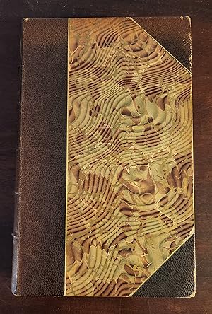
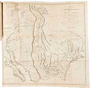
[DeWitt Clinton Copy] An Account of Expeditions to the Sources of the Mississippi, and through the Western Parts of Louisiana, to the Sources of the Arkansaw, Kans, La Platte, and Pierre Jaun, Rivers During the years 1805, 1806 and 1807. And a Tour through the Interior Parts of New Spain. in the year 1807.
Edité par Pike, 1810
Vendeur : Barry Lawrence Ruderman, La Jolla, CA, Etats-Unis
Membre d'association : ABAA ILAB
Evaluation du vendeur :
Carte
No Binding. Etat : VG+. Pike / 1810 / [DeWitt Clinton Copy] An Account of Expeditions to the Sources of the Mississippi, and through the Western Parts of Louisiana, to the Sources of the Arkansaw, Kans, La Platte, and Pierre Jaun, Rivers During the years 1805, 1806 and 1807. And a Tour through the Interior Parts of New Spain. in the year 1807. (Safe 4, 81745) 8vo (210 x 130 mm). Six maps (five folding) and three folding charts; usual offsetting to title, minor scattered spotting, Contemporary marbled sheep, red morocco label. Calf clamshell case, gilt leather label. The DeWitt Clinton Copy of the First Edition of the First Government-Sanctioned Exploration of the American Southwest Important association copy of Zebulon Pike s important account of his two expeditions into the American West. Operating on the orders of Thomas Jefferson, Pike s observations were crucial to the expansion of the United States. His maps were the first to show the trans-Mississippi West in such exacting detail, and the first to be based on first-hand observations. This example is notable additionally because it belonged to U.S. Senator and New York City mayor DeWitt Clinton (1769-1828). As noted by Richard Brookhiser: Politics was DeWitt Clinton s job but not his only interest. He thought of himself as what we would now call a public intellectual. He belonged to a public-spirited class of gentlemen who helped found the growing city s learned societies the American Academy of the Arts, the Literary and Philosophical Society, and the New-York Historical Society. . . He gave a lecture, famous in its day, surveying American intellectual life: entitled Introductory Discourse, it proudly recounted our achievements (Benjamin Franklin s inventions, Zebulon Pike s discoveries) and anxiously fretted over our shortcomings ( we are far behind our European brethren in the pursuits of literature ). . . [An Introductory Discourse Delivered Before the Literary and Philosophical Society of New-York on the Fourth of May, 1814, By De Witt Clinton L.L. D . . . (1815)] Zebulon Pike s expeditions in the American West Zebulon Pike was born in 1779 in New Jersey; his father was an officer in the Continental Army during the American Revolution. A teenage Zebulon followed in his footsteps, joining the army after being raised on a series of western outposts. One of his first assignments was to trail the French expedition under General Georges Henri Victor Collot, which was mapping the Mississippi frontier. Following the Louisiana Purchase, President Thomas Jefferson needed to know more about the vast swath of land he had purchased, as well as extend American sovereignty into an area that already contained French, British, and Spanish trappers and traders. Additionally, he needed to create new treaties and relationships with the Indigenous peoples. To achieve these aims, Jefferson ordered several expeditions into the American West, including the Lewis and Clark expedition and what are now known as the first and second Pike expeditions. Initially, Lieutenant Pike was charged with the command of a reconnaissance expedition to find the source of the Mississippi River. Pike s mission left St. Louis on April 9, 1805 with orders to expel fur traders operating illegally within US borders, to establish cordial relations with several powerful tribes, and to survey the Mississippi and its tributaries. They set off upstream and reached the convergence of the Mississippi and t. Map.
-
An Account of Expeditions to the Sources of the Mississippi, and Through the Western Parts of Louisiana, to the Sources of the Arkansaw, Kans, La Platte, and Pierre Juan, Rivers . During the Years 1805, 1806, and 1807. And a Tour Through the Interior Parts of New Spain . In the Year 1807
Edité par John Binns for C.&A. Conrad; Petersburgh: Somervell & Conrad; Norfolk: Bonsal, Conrad & Co.; and Baltimore: Fielding Lucas, Jr., Philadelphia, 1810
Vendeur : James Cummins Bookseller, ABAA, New York, NY, Etats-Unis
Membre d'association : ABAA ILAB
Evaluation du vendeur :
Edition originale
First edition. First edition. Frontispiece portrait, 3 folding tables, a chart (on 5 separate leaves) and 6 maps (5 folding). 5, [3], 277, [5]; 65, [1]; 53, [1]; 87, [1] pp. 1 vols. 8vo. The report of the first, and certainly one of the most important, exploration narratives of the Southwest. Pike's narrative includes his account of his travels to explore the headwaters of the Arkansas and Red Rivers, as well as his earlier journey to the sources of the Mississippi River. He also relates his visit to the Spanish settlements in New Mexico. Along with the writings of Lewis & Clark, Pike's ACCOUNT must stand as the most important early work on western exploration. The maps, which Wheat considers "milestones in the mapping of the American west," are the first to show geographic knowledge of the area based upon first-hand explorations. Streeter refers to the description of Texas as "excellent." Howes P-373, "b"; Wagner-Camp 9:1; Graff 3290; Wheat Transmississippi 297, 298, 299; Field 1217; Streeter Texas 1047C; Bradford 4415; Rittenhouse 467; Sabin 62936; Jones 743; Braislin 1474; Jenkins Basic Texas Books 163; Hill 1357; Reese, Best of the West, # 32 Contemporary tree calf, red morocco spine label titled in gilt. Binding rubbed, joints starting, dampstain to frontispiece and title, offsetting from frontispiece, some browning and spotting to text, offsetting and foxing to maps, small tears at mounts, repairs to 1 folding chart and Mississippi River map. In a custom blue cloth slipcase and chemise Frontispiece portrait, 3 folding tables, a chart (on 5 separate leaves) and 6 maps (5 folding). 5, [3], 277, [5]; 65, [1]; 53, [1]; 87, [1] pp. 1 vols. 8vo.
-
An account of expeditions to the Sources of the Mississippi, and through the western parts of Louisiana, to the sources of the Arkansaw, Kans, La Platte, and Pierre Juan, Rivers; performed by order of the Government of the United States during the years 1805, 1806, and 1807. And a tour through the Interior parts of New Spain, when conducted through these provinces, by order of The Captain-General, in the year 1807. By Major Z. M. Pike. Illustrated by maps and charts
Edité par John Binns for C. & A. Conrad & Co, Philadelphia, 1810
Edition originale
Hardcover. Etat : Very good. First. First edition. Philadelphia: printed by John Binns for C. & A. Conrad & Co.; Somervell & Conrad; Bonsal, Conrad, & Co; and Fielding Lucas, Jr.; 1810. Octavo in 4s (8 1/4" x 5 3/16", 210mm x 131mm). [Full collation available.] With 6 leaves of letterpress tables printed on 11 pages, 3 folding tables, 1 engraved map, and 5 folding engraved maps. Bound in contemporary calf. On the spine, 5 raised bands flanked by gilt fillets. Author and title gilt to red morocco in the second panel. All edges of text block speckled blue. Hinges rubbed. Upper fore-corner of the front board worn. Head piece cracked. Generally scuffed. Mild foxing throughout text, a few preserved deckles. Offsetting of engravings. Old tape repair to the verso of one of the folding maps (the first part of Captn Pike's chart of the Internal Part of Louisiana). XIXc ownership inscriptions to the title-page, dated Baltimore 1821. In 1805, then-Lieutenant Zebulon Pike (1779-1813) was chosen by the Jefferson administration to trace the origins of the Mississippi River in the newly acquired Louisiana territory. This expedition was conducted in conjunction with the famous Lewis and Clark expedition, which traced the origins of the Missouri river. Soon after, Pike was instructed to explore the Arkansas and Red Rivers and, missing the latter entirely, wound up in Spanish territory. The Spanish authorities arrested him and confiscated his maps and papers, but his journals remained hidden within the barrels of the guns of his men. The publication of this book in 1810 allowed the American people to gain access to a wealth of knowledge about the newly explored West, from accounts of flora and fauna to weather conditions. The scope of Pike's investigation was vast and yet precise. His account remained easy to read due to its diaristic structure. It was so popular that it was soon translated into Dutch, French, and German so that it could be circulated within Europe. It in turn fueled westward expansion in the XIXc and is the spiritual sister to the Lewis and Clark accounts. The name "Benj. F. Robertson" and "Baltimore 1821" are written on the title page in a similar hand, the former cancelled. Written above is "Edw. P. Littlefield" in a different hand, also cancelled. Graff 3290; Howes P 373; Sabin 62836; Streeter Sale 3125; Wagner-Camp 9:1; Wheat, Transmississippi West 297-299.
-
An account of expeditions to the Sources of the Mississippi, and through the western parts of Louisiana, to the sources of the Arkansaw, Kans, La Platte, and Pierre Juan, Rivers; performed by order of the Government of the United States during the years 1805, 1806, and 1807. And a tour through the Interior parts of New Spain, when conducted through these provinces, by order of The Captain-General, in the year 1807. By Major Z. M. Pike. Illustrated by maps and charts
Edité par John Binns for C. & A. Conrad & Co, Philadelphia, 1810
Edition originale
Hardcover. Etat : Very good. First. First edition. Philadelphia: printed by John Binns for C. & A. Conrad & Co.; Somervell & Conrad; Bonsal, Conrad, & Co; and Fielding Lucas, Jr.; 1810. Octavo in 4s (8 3/8" x 5 1/8", 213mm x 130mm). [Full collation available.] With 6 leaves of letterpress tables printed on 11 pages, 3 folding tables, 1 engraved map, and 5 folding engraved maps. Bound in half calf over marbled boards. On the spine, seven gilt double fillet bands. Author and title gilt to red morocco in the second panel. Bottom right fore-corner of the front board worn. Some surface tears to boards. Generally scuffed and rubbed. Ripped corner to p. 11. Triangular loss to top of page p. 339. Mild foxing throughout. Ownership inscription to the title page, "James Story's book." Ownership stamp to p. 3 of John G. Michener. In 1805, then-Lieutenant Zebulon Pike (1779-1813) was chosen by the Jefferson administration to trace the origins of the Mississippi River in the newly acquired Louisiana territory. This expedition was conducted in conjunction with the famous Lewis and Clark expedition, which traced the origins of the Missouri river. Soon after, Pike was instructed to explore the Arkansas and Red Rivers and, missing the latter entirely, wound up in Spanish territory. The Spanish authorities arrested him and confiscated his maps and papers, but his journals remained hidden within the barrels of the guns of his men. The publication of this book in 1810 allowed the American people to gain access to a wealth of knowledge about the newly explored West, from accounts of flora and fauna to weather conditions. The scope of Pike's investigation was vast and yet precise. His account remained easy to read due to its diaristic structure. It was so popular that it was soon translated into Dutch, French, and German so that it could be circulated within Europe. It in turn fueled westward expansion in the XIXc and is the spiritual sister to the Lewis and Clark accounts. Although the name "James Story" is too common to definitively match to a historical figure, the John G. Michener stamp likely belongs to a prominent Pennsylvania attorney who died in 1885 whose death was notable enough to be covered in the New York Times. Graff 3290; Howes P 373; Sabin 62836; Streeter Sale 3125; Wagner-Camp 9:1; Wheat, Transmississippi West 297-299.
-
An account of expeditions to the Sources of the Mississippi, and through the western parts of Louisiana, to the sources of the Arkansaw, Kans, La Platte, and Pierre Juan, Rivers; performed by order of the Government of the United States during the years 1805, 1806, and 1807. And a tour through the Interior parts of New Spain, when conducted through these provinces, by order of The Captain-General, in the year 1807. By Major Z. M. Pike. Illustrated by maps and charts
Edité par Conrad et al., Philadelphia, 1810
Edition originale
Hardcover. Etat : Very good. First. NAVAL HERO LT. RALPH IZARD'S COPY. Philadelphia: printed by John Binns for C. & A. Conrad & Co.; Somervell & Conrad; Bonsal, Conrad, & Co.; and Fielding Lucas, Jr.; 1810. First edition. Octavo in 4s (8 1/4" x 5 1/8"m 209mm x 129mm). [Full collation available.] With 2 engraved plates, 6 letterpress tables, 3 folding letterpress tables and 5 folding engraved maps. Bound in later half morocco over brown cloth, with gilt fillets at the edges. On the spine, five raised bands. Title gilt to the second panel, author gilt to the fourth, imprint gilt at the tail. All edges of the text-block sprinkled brown. Rubbed at the hinges and fore-corners, wear to the upper rear fore-corner. Evenly tanned, with intermittent foxing and offsetting. Some minimal tissue-repairs to the folds of the maps. Ownership signature of Ralph D.(?) Izard to the title-page, and below, the violet ink-stamp of Rudolph McGirr. In 1805, then-Lieutenant Zebulon Pike (1779-1813) was chosen by the Jefferson administration to trace the origins of the Mississippi River in the newly acquired Louisiana territory. This expedition was conducted in conjunction with the famous Lewis and Clark expedition, which traced the origins of the Missouri river. Soon after, Pike was instructed to explore the Arkansas and Red Rivers and, missing the latter entirely, wound up in Spanish territory. The Spanish authorities arrested him and confiscated his maps and papers, but his journals remained hidden within the barrels of the guns of his men. The publication of this book in 1810 allowed the American people to gain access to a wealth of knowledge about the newly explored West, from accounts of flora and fauna to weather conditions. The scope of Pike's investigation was vast and yet precise. His account remained easy to read due to its diaristic structure. It was so popular that it was soon translated into Dutch, French, and German so that it could be circulated within Europe. It in turn fueled westward expansion in the XIXc and is the spiritual sister to the Lewis and Clark accounts. Lieutenant Ralph DeLancey Izard (1785-1822) was the son of South Carolina's first senator, Ralph Izard. He was distinguished for valor in the Barbary Wars; on 16 February 1804, Izard, commanding a small sailing vessel, set ablaze the captured frigate Philadelphia in the harbor of Tripoli (captured in one of Edward Moran's most dazzling pictures, painted decades later in 1897). Certainly Ralph's brother George (who served as governor of the Arkansas Territory) knew the author, and so it is certainly possible that the owner knew Pike as well. Rudolph McGirr may be identified with the paymaster at United Gas Improvement Co. in Philadelphia (1842-1910). Graff 3290; Howes P 373; Sabin 62836; Streeter Sale 3125; Wagner-Camp 9:1; Wheat Transmississippi West 297-299 (maps).
-
AN ACCOUNT OF EXPEDITIONS TO THE SOURCES OF THE MISSISSIPPI, AND THROUGH THE WESTERN PARTS OF LOUISIANA, TO THE SOURCES OF THE ARKANSAW, KANS, LA PLATTE, AND PIERRE JAUN, RIVERS.DURING THE YEARS 1805, 1806, AND 1807. AND A TOUR THROUGH THE INTERIOR PARTS OF NEW SPAIN.IN THE YEAR 1807
Edité par Published by C. & A. Conrad, & Co., Philadelphia, 1810
Vendeur : William Reese Company - Americana, New Haven, CT, Etats-Unis
Membre d'association : ABAA ESA ILAB SNEAB
Evaluation du vendeur :
[8],105,[11],[107]- 277,[3],65,[1],53,[1],87pp. plus six maps (five folding) and three folding charts. Frontispiece portrait. 19th-century three- quarter brown morocco and marbled boards, gilt-lettered spine. Slight shelf wear. Offsetting on titlepage as usual. Minor toning and foxing. Contemporary armorial bookplate on front pastedown. Overall very good. The report of the first United States government expedition to the Southwest, and one of the most important of all American travel narratives, including an account of Pike's travels to explore the headwaters of the Arkansas and Red rivers, his earlier journey to explore the sources of the Mississippi River, and his visit to the Spanish settlements in New Mexico. Pike's narrative stands with those of Lewis and Clark, and Long, as the most important of early books on western exploration and as a cornerstone of Western Americana. The maps were the first to exhibit a geographic knowledge of the Southwest based on firsthand exploration and are considered "milestones in the mapping of the American West" (Wheat). "The description of Texas is excellent" - Streeter TEXAS. The Pike expedition probed at the Spanish borderlands, which Jefferson believed were ripe for collapse. Ultimately his expedition was captured by a Spanish military force and expelled from New Spain. HOWES P373, "b." WAGNER-CAMP 9:1. STREETER SALE 3125. WHEAT TRANSMISSISSIPPI 297, 298, 299. GRAFF 3290. FIELD 1217. STREETER TEXAS 1047C. HILL 1357. BRADFORD 4415. RITTENHOUSE 467. SABIN 62936. JONES 743. BRAISLIN 1474. REESE, BEST OF THE WEST 32.
-
An account of expeditions to the Sources of the Mississippi, and through the western parts of Louisiana, to the sources of the Arkansaw, Kans, La Platte, and Pierre Juan, Rivers; performed by order of the Government of the United States during the years 1805, 1806, and 1807. And a tour through the Interior parts of New Spain, when conducted through these provinces, by order of The Captain-General, in the year 1807. By Major Z. M. Pike. Illustrated by maps and charts
Edité par Conrad et al., Philadelphia, 1810
Edition originale
Hardcover. Etat : Near fine. First. First edition. Philadelphia: printed by John Binns for C. & A. Conrad & Co.; Somervell & Conrad; Bonsal, Conrad, & Co; and Fielding Lucas, Jr.; 1810. Octavo in 4s (8 7/8" x 5 1/2", 226mm x 142mm). [Full collation available.] With 2 engraved plates, 6 letterpress tables, 3 folding letterpress tables, and 5 folding engraved maps. Bound in early-XIXc tree calf with a double gilt fillet border. On the spine, seven double gilt fillets. Author and title gilt to red morocco in the second panel. On the edges of the boards, a gilt roll. Faint chipping to the extremities. Mildly evenly tanned, with marginal foxing to quire A. All folding tables and maps backed onto linen, as is the plate illustrating Falls of St. Anthony; with some offsetting. Small loss to the lower fore-corner of 201. Excellent margins (35mm+), with many preserved deckles. Fastidiously bound with extra stubs at the folding plates to prevent splaying of the boards. A lovely example. In 1805, then-Lieutenant Zebulon Pike (1779-1813) was chosen by the Jefferson administration to trace the origins of the Mississippi River in the newly acquired Louisiana territory. This expedition was conducted in conjunction with the famous Lewis and Clark expedition, which traced the origins of the Missouri river. Soon after, Pike was instructed to explore the Arkansas and Red Rivers and, missing the latter entirely, wound up in Spanish territory. The Spanish authorities arrested him and confiscated his maps and papers, but his journals remained hidden within the barrels of the guns of his men. The publication of this book in 1810 allowed the American people to gain access to a wealth of knowledge about the newly explored West, from accounts of flora and fauna to weather conditions. The scope of Pike's investigation was vast and yet precise. His account remained easy to read due to its diaristic structure. It was so popular that it was soon translated into Dutch, French, and German so that it could be circulated within Europe. It in turn fueled westward expansion in the XIXc and is the spiritual sister to the Lewis and Clark accounts. Graff 3290; Howes P 373; Sabin 62836; Streeter Sale 3125; Wagner-Camp 9:1; Wheat, Transmississippi West 297-299.
-
AN ACCOUNT OF EXPEDITIONS TO THE SOURCES OF THE MISSISSIPPI, AND THROUGH THE WESTERN PARTS OF LOUISIANA, TO THE SOURCES OF THE ARKANSAW, KANS, LA PLATTE, AND PIERRE JAUN, RIVERS.DURING THE YEARS 1805, 1806, AND 1807. AND A TOUR THROUGH THE INTERIOR PARTS OF NEW SPAIN.IN THE YEAR 1807
Edité par Published by C. & A. Conrad, & Co. Somervell & Conrad [of] Petersborough. Bonsal, Conrad, & Co. [of] Norfolk, and Fielding Lucas Jr. [of] Baltimore, Philadelphia, 1810
Vendeur : William Reese Company - Americana, New Haven, CT, Etats-Unis
Membre d'association : ABAA ESA ILAB SNEAB
Evaluation du vendeur :
Two volumes. Text: 8,105,[11],[107]-277,[5],65,[1],53,[1],87pp. plus three folding tables. Atlas volume: six engraved maps (five folding) and three folding letterpress tables. Text: Original plain blue-grey paper boards with tan paper backstrip, expertly rebacked in matching paper with most of original backstrip laid down, printed paper label, manuscript spine title. Boards lightly rubbed, soiled and edgeworn, corners bumped. Scattered tanning and staining, an occasional paper flaw (with loss of a few letters on p.44). Atlas: Quarto. Contemporary half speckled calf and marbled boards, expertly rebacked in matching calf with portions of original backstrip laid down. Early bookseller's ticket of "Hugh Hammell's Cheap Bookstore" of Philadelphia on front pastedown. Tanning, some offsetting from plates. Text and atlas in very good condition overall, with the text volume untrimmed and appendix to part one unopened. Howes' "best issue" of one of the most important of all American travel narratives: the first edition of the report of the first United States government expedition to the Southwest, including an account of Pike's exploration of the headwaters of the Arkansas and Red rivers, the sources of the Mississippi River, and the Spanish settlements in New Mexico. This copy is in its original binding with the atlas bound separately, and is very unusual thus. Pike's narrative stands with those of Lewis and Clark and Long as among the most important early books on western exploration and as a cornerstone of Western Americana. "In 1805, Pike was given the difficult assignment of conducting a reconnaissance of the upper Mississippi region. He was ordered to explore the headwaters of that river, to purchase sites from the Indians for further military posts, and to bring a few influential chiefs back to St. Louis for talks. The trip was only moderately successful as a mission to the tribes, but Pike was able to convey important geographical information to President Jefferson and other Washington officials. On Pike's second expedition, 1806-1807, he was assigned to explore the head-waters of the Arkansas River, then proceed south and descend the Red River from its source.Pike and his men were taken into custody by a Spanish patrol, and Pike was able to observe many areas in New Mexico, Chihuahua, and Texas.His book created interest in the Southwest and stimulated the expansionist movement in Texas" - Hill. The maps were the first to exhibit a geographic knowledge of the Southwest based on firsthand exploration and are considered "milestones in the mapping of the American West" (Wheat). "The description of Texas is excellent" - Streeter, TEXAS. This work was published in two forms: as a single octavo volume with all the maps and tables bound in, or, as here, in two volumes with the maps and folding tables in a quarto volume. This latter form was recognized by Howes as being the "best issue." It is quite uncommon to find the text and atlas bound separately, even more so to find them in their original bindings, as here. A very desirable set of a landmark work of western exploration. HOWES P373, "b." WAGNER-CAMP 9:1. STREETER SALE 3125. WHEAT TRANSMISSISSIPPI 297, 298, 299. GRAFF 3290. FIELD 1217. STREETER TEXAS 1047C. HILL 1357. BRADFORD 4415. RITTENHOUSE 467. SABIN 62936. JONES 743. BRAISLIN 1474. REESE, BEST OF THE WEST 32.
-
An account of expeditions to the Sources of the Mississippi, and through the western parts of Louisiana, to the sources of the Arkansaw, Kans, La Platte, and Pierre Juan, Rivers; performed by order of the Government of the United States during the years 1805, 1806, and 1807. And a tour through the Interior parts of New Spain, when conducted through these provinces, by order of The Captain-General, in the year 1807. By Major Z. M. Pike. Illustrated by maps and charts
Edité par John Binns for C. & A. Conrad & Co, Philadelphia, 1810
Edition originale
Hardcover. Etat : Very good. First. First edition. Two volumes. Philadelphia: printed by John Binns for C. & A. Conrad & Co.; Somervell & Conrad; Bonsal, Conrad, & Co; and Fielding Lucas, Jr.; 1810. Text: octavo in 4s (8 7/16" x 5 3/16", 214mm x 132mm). [Full collation available.] With 6 leaves of letterpress tables printed on 11 pages, and 3 folding letterpress tables. Atlas: (8 1/2" x 5 5/8", 218mm x 142mm): 6 engraved maps, 5 of which are folded. Text: bound in contemporary spotted calf. On the spine, 6 panels. Author and title gilt to red morocco in the second panel. Gilt roll to the edges of the boards. All edges of the text block glazed black. Atlas: bound in quarter sheep over marbled boards. Presented in a quarter blue morocco slip-case with chemises. Text: Hinges starting and rubbed. Fore-corners worn. Edges rubbed. Text evenly tanned. Mild offsetting at the engravings. Ink ownership signature of "Wm Priestman" to the front paste-down. Ink and pencil notes to front free-end-page. Pencil marginalia to pp. 170, 171, and p. 9 of the appendix to part III (171v). Ink marginalia to p. 13 of the appendix to part I (23r). Atlas: Hinges rubbed. Loss to the head of the spine. Boards rubbed, with small patches of wear. Ink-stains to the boards. Edges of the boards worn. Offsetting at the "Falls of St Anthony." Pencil notes to verso of "Map of the Mississippi River." Tape repair to verso of "A Map of the Internal Provinces of New Spain." Mild foxing throughout. In 1805, then-Lieutenant Zebulon Pike (1779-1813) was chosen by the Jefferson administration to trace the origins of the Mississippi River in the newly acquired Louisiana territory. This expedition was conducted in conjunction with the famous Lewis and Clark expedition, which traced the origins of the Missouri river. Soon after, Pike was instructed to explore the Arkansas and Red Rivers and, missing the latter entirely, wound up in Spanish territory. The Spanish authorities arrested him and confiscated his maps and papers, but his journals remained hidden within the barrels of the guns of his men. The publication of this book in 1810 allowed the American people to gain access to a wealth of knowledge about the newly explored West, from accounts of flora and fauna to weather conditions. The scope of Pike's investigation was vast and yet precise. His account remained easy to read due to its diaristic structure. It was so popular that it was soon translated into Dutch, French, and German so that it could be circulated within Europe. It in turn fueled westward expansion in the XIXc and is the spiritual sister to the Lewis and Clark accounts. William Priestman marks an intersection -- Market & Ninth St. in Philadelphia -- that is presumably where the book was bought, followed by a likely shelfmark of his personal library. On May 19, 1831 The National Gazette contains an advertisement for the estate sale of William Priestman, Esq.'s ".very valuable and extensive Library.comprising many rare and excellent works." It is very likely that this book was part of that library. Graff 3290; Howes P 373; Sabin 62836; Streeter Sale 3125; Wagner-Camp 9:1; Wheat, Transmississippi West 297-299.
-
An account of expeditions to the Sources of the Mississippi, and through the western parts of Louisiana, to the sources of the Arkansaw, Kans, La Platte, and Pierre Jaun, Rivers; performed by order of the Government of the United States during the years 1805, 1806, and 1807. And a tour through the Interior parts of New Spain, when conducted through these provinces, by order of The Captain-General, in the year 1807. By Major Z. M. Pike. Illustrated by maps and charts
Edité par Conrad et al., Philadelphia, 1810
Edition originale
Hardcover. Etat : Near fine. First. FIRST EDITION, AND A RARE SURVIVAL IN PUBLISHER'S BOARDS. Philadelphia: printed by John Binns for C. & A. Conrad & Co.; Somervell & Conrad; Bonsal, Conrad, & Co.; and Fielding Lucas, Jr.; 1810. First edition. Octavo in 4s (9 1/8" x 5 7/8", 231mm x 149mm). [Full collation available.] With 2 engraved plates, 6 letterpress tables, 3 folding letterpress tables and 5 folding engraved maps. Bound in the publisher's blue drab boards with beige tape backing. Fore and lower edges of the text-block untrimmed. Presented in a blue cloth clam-shell box with a blue morocco spine-label gilt. Hinges cracked, with some losses to the tape-backing. Some soiling to the boards, with a few abrasions and creases. Closed tear to the lower edge of A2. Transverse closed tear to 1[sub]1, repaired verso with plastic tape. Ink marginalium to 9[sub]4v (p. 6 of the Appendix to Part II). A little tanning and some spots generally. An exceptionally tall survival in publisher's boards. In 1805, then-Lieutenant Zebulon Pike (1779-1813) was chosen by the Jefferson administration to trace the origins of the Mississippi River in the newly acquired Louisiana territory. This expedition was conducted in conjunction with the famous Lewis and Clark expedition, which traced the origins of the Missouri river. Soon after, Pike was instructed to explore the Arkansas and Red Rivers and, missing the latter entirely, wound up in Spanish territory. The Spanish authorities arrested him and confiscated his maps and papers, but his journals remained hidden within the barrels of the guns of his men. The publication of this book in 1810 allowed the American people to gain access to a wealth of knowledge about the newly explored West, from accounts of flora and fauna to weather conditions. The scope of Pike's investigation was vast and yet precise. His account remained easy to read due to its diaristic structure. It was so popular that it was soon translated into Dutch, French, and German so that it could be circulated within Europe. It in turn fueled westward expansion in the XIXc and is the spiritual sister to the Lewis and Clark accounts. A single marginalium -- "two than five" against ". . .the sandy soil. . . renders the river (in dry seasons) less navigable five hundred miles" -- is the only clue to ownership. The section discusses the "Rio del Norte," which we now would call the upper Rio Grande within New Mexico, and so the annotator must either have been familiar with the river's behavior from personal experience or from another work on the region. Graff 3290; Howes P 373; Sabin 62836; Streeter Sale 3125; Wagner-Camp 9:1; Wheat Transmississippi West 297-299 (maps).


![Image du vendeur pour [DeWitt Clinton Copy] An Account of Expeditions to the Sources of the Mississippi, and through the Western Parts of Louisiana, to the Sources of the Arkansaw, Kans, La Platte, and Pierre Jaun, Rivers During the years 1805, 1806 and 1807. And a Tour through the Interior Parts of New Spain. in the year 1807. mis en vente par Barry Lawrence Ruderman](https://pictures.abebooks.com/inventory/md/md31306546177.jpg)