Montant total (1 article articles) :
Destination de la commande :

carrick ballyshannon manor hamilton coloony de taylor skinner (3 résultats)
Passer aux résultats principaux de la recherche
Type d'article
- Tous les types d'articles
- Livres
- Magazines & Périodiques
- Bandes dessinées
- Partitions de musique
- Art, Affiches et Gravures
- Photographies
- Cartes (3)
-
Manuscrits &
Papiers anciens
Etat
- Tous
- Neuf
- Ancien ou d'occasion
Reliure
- Toutes
- Couverture rigide
- Couverture souple
Particularités
- Edition originale
- Signé
- Jaquette
- Avec images
- Sans impression ŕ la demande
Pays
Evaluation du vendeur
-
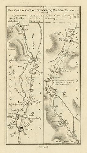
Etat : Good. #234 Carrick to Ballyshannon. Manorhamilton to Coloony. TAYLOR/SKINNER 1778 map. Antique copperplate road map; George Taylor & Andrew Skinner (1778). 23.0 x 13.0cm, 9 x 5 inches. Condition: Good. There is another map printed on the reverse side: #233 From Granard to Ballymahon which includes the towns of Ballymahon, Granard, Barry, Taghshinny, Swanlinbar, Edgeworthstown and covers part of the counties of Longford, Cavan. The map includes the towns of Manorhamilton, Ballintra, Leitrim, Carrick-on-Shannon and covers part of the counties of Leitrim, Donegal.
-
From Carrick to Ballyshannon // from Manor Hamilton to Coloony, to the 5Th Mile, see last page
Date d'édition : 1778
Carte
Etat : Good. #235 Ballyshannon Collooney Belleek Dromahair. TAYLOR/SKINNER 1778 old map. Antique copperplate road map; George Taylor & Andrew Skinner (1778). 23.0 x 13.0cm, 9 x 5 inches. Condition: Good. There is another map printed on the reverse side: #236 From Roscommon to Ballinasloe, Eyrecourt & Portumna which includes the towns of Ballinamore, Ballinasloe, Roscommon, Athleague, Ahascragh and covers part of the counties of Roscommon, Galway, Leitrim. The map includes the towns of Ballyshannon, Belleek, Dromahair, Ballintogher, Collooney and covers part of the counties of Sligo, Leitrim, Fermanagh, Donegal.
-
![Image du vendeur pour From Carrick to Ballyshannon [and] From Manor Hamilton to Coloony, to the 5th Mile, see last page. [and on verso] From Carrick to Ballyshannon, From Man.r Hamilton to Coloony. mis en vente par Robert Frew Ltd. ABA ILAB](https://pictures.abebooks.com/inventory/md/md17237132443.jpg)
From Carrick to Ballyshannon [and] From Manor Hamilton to Coloony, to the 5th Mile, see last page. [and on verso] From Carrick to Ballyshannon, From Man.r Hamilton to Coloony.
Edité par Originally published for the Authors.Sold by T. Longman. London and W. Wilson. Dublin., 1783
Vendeur : Robert Frew Ltd. ABA ILAB, London, Royaume-Uni
Membre d'association : ABA ILAB PBFA
Evaluation du vendeur :

Carte
(25 x 14.5 cm). Uncoloured. Original copper engraved road maps printed in two columns on recto and two columns on verso. Both sides clean and in good condition.