
Montant total (1 article articles) :
Destination de la commande :

carte lempire mexique lhistoire generale de bellin jacques nicolas (2 résultats)
Passer aux résultats principaux de la recherche
Type d'article
- Tous les types d'articles
- Livres (1)
- Magazines & Périodiques
- Bandes dessinées
- Partitions de musique
- Art, Affiches et Gravures
- Photographies
- Cartes (1)
-
Manuscrits &
Papiers anciens
Etat
- Tous
- Neuf
- Ancien ou d'occasion
Reliure
- Toutes
- Couverture rigide
- Couverture souple
Particularités
- Edition originale
- Signé
- Jaquette
- Avec images
- Sans impression ŕ la demande
Pays
Evaluation du vendeur
-
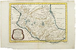
CARTE DE L'EMPIRE DU MÉXIQUE Pour l'Histoire Générale des Voyages 1754
Edité par Paris 1754, 1754
Vendeur : Peter Harrington. ABA/ ILAB., London, Royaume-Uni
Membre d'association : ABA ILAB PBFA
Evaluation du vendeur :

Excellent map of early Mexico shows the City of Mexico on the lakes in the centre. Locates both the Gulf and Pacific coasts with harbors, capes & bays. Inland depicts lakes & mountains and major towns and settlements; Guadalaxara, Compostelle, Chiamedan, Guaxaco, Zacatula and Vera Cruz. Ornamental title cartouche with flower & scroll motifs to the lower left. Copper engraving. Hand coloured. Good condition. Size: 30.5 x 21.5 cm.
-
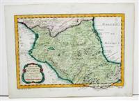
Carte de l'Empire du Mexique Pour l'Histoire Generale des Voyages
Edité par Paris, 1754
Vendeur : Alexandre Antique Prints, Maps & Books, Toronto, ON, Canada
Membre d'association : ABAC ILAB
Evaluation du vendeur :

Carte
Etat : Good; some paper discoloration. Size : 218x305 (mm), 8.625x12 (Inches), Hand Colored.