Montant total (1 article articles) :
Destination de la commande :

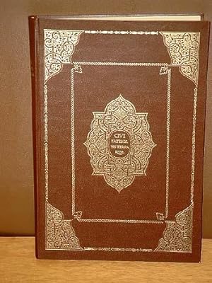
civitates orbis terrarum (308 résultats)
Passer aux résultats principaux de la recherche
Type d'article
- Tous les types d'articles
- Livres (263)
- Magazines & Périodiques
- Bandes dessinées
- Partitions de musique
- Art, Affiches et Gravures (39)
- Photographies (1)
- Cartes (3)
-
Manuscrits &
Papiers anciens (2)
Etat
Reliure
Particularités
Livraison gratuite
Pays
Evaluation du vendeur
-
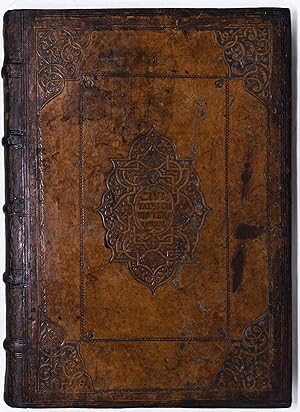
Hardcover. Etat : Near fine. Five volumes. Cologne: Bertram Buchholtz, 1599-1597-1606-[1599]-ca. 1600. Folio (15 11/16" x 11 1/16", 398mm x 280mm). Collated complete, except for II.4(?)2 blank, IV.Ď 1 (part 4 title-page) and IV.2Ď 2 blank. Bound in contemporary calf with the "standard Civitates binding" offered by Hogenberg, tooled gilt originally but now mostly rubbed to blind. On the spine, five raised bands with triple blind fillets above and below. Title gilt to the second panel, number gilt to the third. All edges of the text-block glazed red. Each volume presented in an archival phase box. Lacking the part 4 title-page and two blanks (as enumerated above). Conserved in October 2021 by James and Stuart Brockman (full report available). The following ten plates have been supplied from other copies: I.8 (Montpellier), I.9 (Rouen), I.35 (Frankfurt); II.24 (Dordrecht); III.4 (Edinburgh), III.36 (Leeuwarden), III.37 (Soest and Warburg), III.38 (Frankenberg), III.44 (Zurich); IV.32 (Bad Segeberg). Some foxing to the preliminaries. Ink marginalia in an old (XVIIc?) hand in Spanish throughout, with concentrations to the Spanish views of vol. I (41r, Granada; 51r, Barcelona) and to the preliminaries of vol. V. Contemporary coloring throughout, with fine gilding to the title-pages. Although Civitates Orbis Terrarum -- Cities of the World -- is the title given only to the first part of the work, it admirably describes what is otherwise named for its principal creators: Braun & Hogenberg. Georg Braun (Bruin in Dutch; 1541-1622) was the managing editor as well as the author of the descriptions appended to each plate. Frans Hogenberg (1543-1590) was fresh from his collaboration with Abraham Ortelius (the Theatrum Orbis Terrarum) when he suggested a complimentary account of the beacon of civilized life: the city. The project took some 40 years to come to completion; the first edition of part 1 was published in 1572, the first edition of part 6 was published in 1617 (the present set, as often, stops with part 5). As the cities of Europe (principally; there are views of cities on three additional continents: North America (Mexico and Cuzco, I.58), Africa (Cairo, Tangier, Casablanca; I.55-57) and Asia (Aden, I.53; Calicut, I.54 and Jerusalem several times) grew in size and splendor, there was a desire to document their features and organization. In part an exercise in civic pride, the views Braun chose were often drawn by local artists, and so there is an aspect of self-presentation as opposed to the intended accuracy of atlases proper. Although Dutch atlases are sometimes described as a bibliographer's nightmare, the Civitates is, properly, neither Dutch nor an atlas. Whereas other works of this sort often comprised a constantly-shifting buffet of updated plates that would replace one another, Braun and Hogenberg simply added new views and plans as they became available without replacing. Thus the work is unusually historicized, allowing the viewer to follow the development of, say, Jerusalem from 1572 (I.52) to 1575 (II.54) to 1588 (IV.58-59). The Spanish owner of the present set, perhaps from Barcelona given the volume of the annotations to its plate-text (I.5), was in a position to correct or to add information; there are no citations, so perhaps comments are from his own experience. Whereas the fate of the Civitates is often the framer's knife, having the set with early marginalia shows that the volumes were used as records and windows of the development of the early modern city. Van der Kroegt/Koeman IV.1: 41:1.1(1599), .2(1597), .3(1606), .4([1559])B, .5(1600).
-
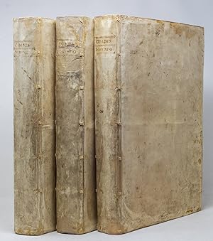
Hardcover. Etat : Near fine. THE COMPLETE SERIES OF BRAUN AND HOGENBERG'S CITY VIEWS. Cologne: Petrus von Brachel, 1612-[1612]-1616-1617-[1617]-1618 (i.e., 1617/8) Folio (15 15/16" x 10 3/4", 404mm x 274mm). [Full collation available.] With 4 (of 6) hand-colored engraved title-pages and 364 (of 363; 5.14 is duplicated as 5.[chi]20) double-page hand-colored engraved plates (of which three are large-format folding plates: 5.27 (Antwerp) and 6.43 and 6.44 (Krakow). Additionally lacking 3.[pi]2 and 6.[chi]2. Else collated perfect against Van der Kroegt/Koeman. Bound in contemporary laced stiff vellum with yapp edges. On the spine in ink manuscript between double fillets CIDADES/ DO MVNDO. All edges of the text-block gilt. Presented in velvet-lined quarter black morocco clam-shell boxes. Restored in early 2021 by Stuart Brockman (full restoration report available). Seven plates (2.3, 2.19; 5.14-16, 5.37; 6.2) supplied from other copies (6.2 slightly smaller). Tanning throughout, moderate in places, especially from pigment burn. Some general soiling to the covers, as ever with vellum. Although Civitates Orbis Terrarum -- Cities of the World -- is the title given only to the first part of the work, it admirably describes what is otherwise named for its principal creators: Braun & Hogenberg. Georg Braun (Bruin in Dutch; 1541-1622) was the managing editor as well as the author of the descriptions appended to each plate. Frans Hogenberg (1543-1590) was fresh from his collaboration with Abraham Ortelius (the Theatrum Orbis Terrarum) when he suggested a complimentary account of the beacon of civilized life: the city. The project took some 40 years to come to completion; the first edition of part 1 was published in 1572, the first edition of part 6 was published in 1617. As the cities of Europe (principally; there are in fact views of cities on three additional continents: North America (Mexico and Cuzco, 1.58), Africa (Cairo, Tangier, Casablanca; 1.55-57) and Asia (Aden, 1.53; Calicut, 1.54 and Jerusalem several times) grew in size and splendor, there was a desire to document their features and organization. The views Braun chose were often drawn by local artists, and so there is an aspect of self-presentation as opposed to the intended accuracy of atlases proper. Although Dutch atlases are sometimes described as a bibliographer's nightmare, the Civitates is, properly, neither Dutch nor an atlas. Whereas other works of this sort often comprised a constantly-shifting buffet of updated plates that would replace one another, Braun and Hogenberg simply added new views and plans as they became available without replacing. Thus the work is unusually historicized, allowing the viewer to follow the development of, say, Jerusalem from 1572 (1.52) to 1575 (2.54) to 1588 (4.58-59). The owner of the present item waited until the publication of the final part (1617/8)s to purchase a uniform set: the most up-to-date edition of each volume, all by the Cologne publisher Petrus von Brachel. The only indication of the binder/owner's identity is the title on the spine (Cidades do Mundo): he was Portuguese. The relationship between Portugal and the rest of Europe in the early XVIIc was tempestuous, and so we feel in the set a certain rivalry: whose city has the most or most splendid spires, the greatest market, the most organized plan? The Civitates gave wide access to city planning in a variety of countries and climates, and allowed for a cross-pollination of best practices as cities ballooned into the XVIIc. Individual leaves from the Civitates have circulated widely for centuries, and as a result complete sets -- all six parts with all plates present -- are rare indeed, even in institutional collections. A contemporary binding (especially in vellum) in such fine condition is even rarer still. This may well be the ultimate trophy in picturing the development of the city. Van der Kroegt/Koeman IV.1: 1: 41:1.1(1612)A, .2(1612), .3(1616), .4(1617), .5(1617), 6(1617/18)B.
-
Civitates Orbis Terrarum
Edité par Bertram Buchholtz and Petrus von Brachel, Cologne, 1597
Edition originale
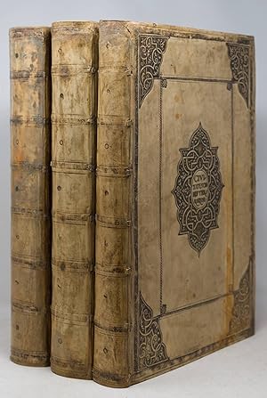
Hardcover. Etat : Very good. Five parts in three volumes. Cologne: Bertram Buchholtz, 1599-1597; Petrus von Brachel, 1606-[1612]; [Buchholtz or von Brachel, 1600]. Folio (15 15/16" x 11 1/8", 404mm x 283mm). [Full collation available.] Collated complete against Van der Kroegt/Koeman but lacking 2.29: Noviomagivm/Nijmigen. Bound in contemporary laced vellum with yapp edges and ties, with the "standard Civitates binding" offered by Hogenberg (although typically in calf). On the front covers, the parts indicated in ink manuscript (I.II, III.IV, V). On the spine, seven panels (vol. I partially re-backed) separated by silver-gilt rolls. Date of binding (?) silver-gilt to panels 2, 3, 5 and 6 (9, 0, 6, 1; i.e., 1609). Silver-gilt rosettes in panels 1, 4 and 7. All edges of the text-block gauffered gilt. Presented in custom green morocco-backed black cloth clam-shell boxes, lipped and lined in dark green velvet, made by Brockman. Conserved in 2021 by James & Stuart Brockman Ltd. (full report available). Vol. I partially re-backed (at the lower half) to style. Some soiling to the bindings generally. Text-block tanned, moderately in places. Five gatherings (2.5, 2.48, 3.23, 4.28, 5.12) were smaller, perhaps indicating their insertion from another set. Graphite annotations made to the dedication (I.1.A2r) against the name of Rudolph II: "Imp. 12.8.e1576/ Morto-20.Geno. 1612 Although Civitates Orbis Terrarum -- Cities of the World -- is the title given only to the first part of the work, it admirably describes what is otherwise named for its principal creators: Braun & Hogenberg. Georg Braun (Bruin in Dutch; 1541-1622) was the managing editor as well as the author of the descriptions appended to each plate. Frans Hogenberg (1543-1590) was fresh from his collaboration with Abraham Ortelius (the Theatrum Orbis Terrarum) when he suggested a complimentary account of the beacon of civilized life: the city. The project took some 40 years to come to completion; the first edition of part 1 was published in 1572, the first edition of part 6 was published in 1617 (the present set, as often, stops with part 5). As the cities of Europe (principally; there are views of cities on three additional continents: North America (Mexico and Cuzco, I.58), Africa (Cairo, Tangier, Casablanca; I.55-57) and Asia (Aden, I.53; Calicut, I.54 and Jerusalem several times) grew in size and splendor, there was a desire to document their features and organization. In part an exercise in civic pride, the views Braun chose were often drawn by local artists, and so there is an aspect of self-presentation as opposed to the intended accuracy of atlases proper. Although Dutch atlases are sometimes described as a bibliographer's nightmare, the Civitates is, properly, neither Dutch nor an atlas. Whereas other works of this sort often comprised a constantly-shifting buffet of updated plates that would replace one another, Braun and Hogenberg simply added new views and plans as they became available without replacing. Thus the work is unusually historicized, allowing the viewer to follow the development of, say, Jerusalem from 1572 (I.52) to 1575 (II.54) to 1588 (IV.58-59). The graphite inscription marking the regnal dates of the Holy Roman Emperor Rudolf II is the only clue to the ownership of the present set, viz., by an Italian. Van der Krogt/Koeman IV.1 41:1.1(1599) - .2(1597) -.3(1606) - .4(1612) - .5(1600).
-
Encuadernación de tapa dura. Etat : Como Nuevo. Lugar de edición: Colonia, Alemania. Ańos de edición: 1572, 1575, 1581, 1588, 1598 y 1617 respectivamente. Idioma: Latín. Mapas: 360, casi 600 vistas de ciudades a doble página Nş Páginas: 1300 entre los 6 volúmenes Encuadernación: cosido en escartivana con cubiertas en piel caprina, en color tabaco, con estampaciones en seco de época y tejuelo dorado en el lomo. Completo libro de estudios con textos de José Luis Casado Soto revisado y anotado por Agustín Hernando Rica. Ubicación de los Originales: Biblioteca Nacional de Espańa y en la Biblioteca Histórica de la Universidad de Salamanca. Signaturas: R/22248-250, ER/4684-86, (BNE) y BG/32146-32151 (BGUSAL) Número ejemplares: 375. ISBN: 978-84-942508-4-2 CIVITATES ORBIS TERRARUM FACSÍMIL Civitates Orbis Terrarum es un atlas en seis volúmenes en el que se incluyen cerca de 600 vistas, planos y mapas de ciudades. Fue editado por George Braum y Franz Hogenberg. El primer volumen vio la luz en 1572 como un atlas histórico del urbanismo medieval y renacentista. El sexto y último volumen se terminó en 1617. Casi 40 ańos de trabajo intenso de una gran cantidad de eruditos, artesanos y artistas. El grabador de los cuatro primeros volúmenes fue el artista flamenco Frans Hogenberg (1535-1595). Este también había preparado diversos mapas para el atlas de Ortelius. Los grabados de los volúmenes quinto y sexto fueron obra de Simon van den Neuwel (1538-1590).
-

Civitates Orbis Terrarum. "Lutetia, vulagri nomine Paris."
Edité par Cologne: T. Graminaeus, 1572-90., 1572
Vendeur : Arader Galleries - AraderNYC, New York, NY, Etats-Unis
Evaluation du vendeur :

A striking view of Lutetia, more commonly known as Paris. Taken from Braun and Hogenberg s famous Civitates Orbis Terrarum. The plan is decorated with an elegant title cartouche, bearing the city s coat-of-arms; a simple cartouche containing a Parisian poem; and three contemporary dressed figures in the foreground. The former name of Lutetia referred to the Gallo-Roman city, which acted as the predecessor to present-day Paris. The Latin edition of Braun and Hogenberg s atlas frequently uses the original titles to the cities depicted. The map of Paris is presented from a bird s eye perceptive. This urban layout of the city is illustrated very clearly within the city walls, with the river Seine flowing gracefully around the Ile de la Cite. In the 16th century, under the rule of Henry IV, Paris began to undergo a flourishing shift into a rich capital. The bustling houses are close together, with winding roads connecting the different parts of the city.The Ile de la Cite shows us the Notre-Dame Catherdral, whose building completed 300 years earlier. The Palais de la Citie and Saint-Chapelle sit on the lower half of the Ile; built in the 13th century. The top center gives us a glimpse of la Bastille outside of the Paris city walls, just a few decades before it was made famous during the French Revolution. The Civitates Orbis Terrarum ( Atlas of the Cities of the World ) by Braun and Hogenburg is the second oldest printed atlas in the history of world cartography; and the first atlas of towns. Its principal creators and authors were the theologist and editor Georg Braun, the most important engraver and publisher Franz Hogenberg. Other artists involved were Simon van den Neuvel, Georg Hoefnagel, Jacob van Deventer to name a few. Although it was published outside of the Netherlands, the Civitates is considered one of the better examples of the Antwerp School of Cartographers, due to its Flemish style of engraving a trait typical of Dutch atlases from the period. One of the most well-known figures from this school, who also played a key role in the making of this atlas, was Abraham Ortelius. It is frequently thought that the Civitates is the direct and intended companion for Ortelius famous Theatrum Orbis Terrarum (1570). In addition to this, there is evidence of correspondence between these three great men and their ideas to create such an atlas. The first volume of the Civitates Orbis Terrarum was published in Cologne in 1572. Its sixth and final volume appeared later in 1617. The Civitates was a widespread and enormously successful. It was frequently republished and supplemented with new sections with later editions. The maps it contained became exemplary and references; thus often reproduced in smaller formats as illustrations for books by other publishers. The atlas bares over 500 maps, representing an entire era in the lavish history of town-mapping. Earlier collections of city views were heterogeneous productions, limited in scope, and often made no meaningful attempt to render the subjects with any degree of realism. The Civitates, by contrast, contained hundreds of views, including many of smaller towns for which no earlier representations are known, depicted with unprecedented accuracy. Braun corresponded extensively with map sellers and scholars from different cities and countries to achieve the highest level of accuracy in his mapping. In addition, the authors also carried out their own investigations, through detailed on-location drawings of panoramic views of the towns made from some high point. It took over forty years to collect the hundreds of plans contained in the Civitates. The plans, each accompanied by Braun's printed account of the town's history, situation and commerce, form a lavish armchair-traveler's compendium, and provide a uniquely comprehensive view of urban life at the turn of the sixteenth century. The significance of its being printed in Cologne extends to the city s independ.
-
Civitates Orbis Terrarum. "Londinum Feracissimi Angliae Regni Metropolis".
Edité par Cologne: T. Graminaeus, 1572-90, 1572
Vendeur : Arader Galleries - AraderNYC, New York, NY, Etats-Unis
Evaluation du vendeur :
Single page (22 x 16 ˝) Full margins showing the plate mark (foxing, browning, paint smear outside margin, center crease tear 3˝ in.) A fine, hand-colored map depicting London; taken from Braun and Hogenberg's Civitates Orbis Terrarum. This map depicts Elizabethan London in all of its glory, and is the earliest obtainable, surviving map or view of the city. It provides its viewer with the highest level of accuracy and detail. Braun and Hogenberg take care to highlight and label the significant buildings of London, such as the famous Tower. However, the map offers an in depth look at urban life in the 16th century. The Bull and Bear pits in evidence south of the River Thames, two facilities for "animal sporting" during this time period. The River Thames is teeming with Tudor barges and sailing vessels, perhaps from trading with the Dutch. The only bridge across the Thames is London Bridge which joins the City of London to Southwark. The three cities of London, Westminster, and Southwark are depicted as quite separate entities at this time - a remarkable aspect. In the foreground are four Londoners in traditional Tudor dress. The figures are flanked by text; and above the plan the title is flanked by the Royal and the City of London's coats-of-arms. The 'Civitates Orbis Terrarum' ('Atlas of the Cities of the World') by Braun and Hogenburg is the second oldest printed atlas in the history of world cartography; and the first atlas of towns. Its principal creators and authors were the theologist and editor Georg Braun, the most important engraver and publisher Franz Hogenberg. Other artists involved were Simon van den Neuvel, Georg Hoefnagel, Jacob van Deventer - to name a few. Although it was published outside of the Netherlands, the Civitates is considered one of the better examples of the Antwerp School of Cartographers, due to its Flemish style of engraving - a trait typical of Dutch atlases from the period. One of the most well-known figures from this school, who also played a key role in the making of this atlas, was Abraham Ortelius. It is frequently thought that the Civitates is the direct and intended companion for Ortelius' famous 'Theatrum Orbis Terrarum' (1570). In addition to this, there is evidence of correspondence between these three great men and their ideas to create such an atlas. The first volume of the Civitates Orbis Terrarum was published in Cologne in 1572. Its sixth and final volume appeared later in 1617. The Civitates was a widespread and enormously successful. It was frequently republished and supplemented with new sections with later editions. The maps it contained became exemplary and references; thus often reproduced in smaller formats as illustrations for books by other publishers. The atlas bares over 500 maps, representing an entire era in the lavish history of town-mapping. Earlier collections of city views were heterogeneous productions, limited in scope, and often made no meaningful attempt to render the subjects with any degree of realism. The Civitates, by contrast, contained hundreds of views, including many of smaller towns for which no earlier representations are known, depicted with unprecedented accuracy. Braun corresponded extensively with map sellers and scholars from different cities and countries to achieve the highest level of accuracy in his mapping. In addition, the authors also carried out their own investigations, through detailed on-location drawings of panoramic views of the towns made from some high point. It took over forty years to collect the hundreds of plans contained in the Civitates. The plans, each accompanied by Braun's printed account of the town's history, situation and commerce, form a lavish armchair-traveler's compendium, and provide a uniquely comprehensive view of urban life at the turn of the sixteenth century. The significance of its being printed in Cologne extends to the city's independence of being a free imperial state. There were few cities which held.
-
Civitates Orbis Terrarum. "Barcelona. Granata."
Edité par Cologne: T. Graminaeus, 1572-90., 1572
Vendeur : Arader Galleries - AraderNYC, New York, NY, Etats-Unis
Evaluation du vendeur :
Single page (22 x 16 ˝) Full margins showing the plate mark (foxing, browning, center short tear, chipping.) A striking view of Barcelona and Granada; taken from Braun and Hogenebrg s illustrative Civitates Orbis Terrarum. The views are decorated with elegant strapwork cartouches, a fine border, and are delicately hand-colored. Figures are seen standing in the foreground of each view, showing an active daily interaction between two Spaniards. The view of Barcelona shows the city from the northeastern slopes of Montjuich, closed off from the pastoral fields by high city walls. The most curious aspect to this view is the rainbow towering over the river. This could perhaps symbolize the good fortune Barcelona experienced from the royal trades it undertook. The royal shipyards, called reales Atarazanas and date from the 13-14th centuries, dominate the waters. The center of the view creates a focus on the Cathedral and the arsenal. Granada s favorable position at the foot of the fertile grounds of Sierra Nevada is illustrated particularly clearly in this engraving. Around the 8th century, Granada was conquered by the Moors. It functioned as the capital of the independent Moorish kingdom and experienced its greatest successes after 1238. Although Moorish rule in Spain came to an end with the capture of Granada by Ferdinand and Isabella in 1492, the city's link with Moorish culture survived in its architecture, in the layout of its streets and districts, and above all, in the Alhambra fortress. The cathedral of Santa Maria de la Encarnacion became the most important Renaissance church in Spain. The Civitates Orbis Terrarum ( Atlas of the Cities of the World ) by Braun and Hogenburg is the second oldest printed atlas in the history of world cartography; and the first atlas of towns. Its principal creators and authors were the theologist and editor Georg Braun, the most important engraver and publisher Franz Hogenberg. Other artists involved were Simon van den Neuvel, Georg Hoefnagel, Jacob van Deventer to name a few. Although it was published outside of the Netherlands, the Civitates is considered one of the better examples of the Antwerp School of Cartographers, due to its Flemish style of engraving a trait typical of Dutch atlases from the period. One of the most well-known figures from this school, who also played a key role in the making of this atlas, was Abraham Ortelius. It is frequently thought that the Civitates is the direct and intended companion for Ortelius famous Theatrum Orbis Terrarum (1570). In addition to this, there is evidence of correspondence between these three great men and their ideas to create such an atlas. The first volume of the Civitates Orbis Terrarum was published in Cologne in 1572. Its sixth and final volume appeared later in 1617. The Civitates was a widespread and enormously successful. It was frequently republished and supplemented with new sections with later editions. The maps it contained became exemplary and references; thus often reproduced in smaller formats as illustrations for books by other publishers. The atlas bares over 500 maps, representing an entire era in the lavish history of town-mapping. Earlier collections of city views were heterogeneous productions, limited in scope, and often made no meaningful attempt to render the subjects with any degree of realism. The Civitates, by contrast, contained hundreds of views, including many of smaller towns for which no earlier representations are known, depicted with unprecedented accuracy. Braun corresponded extensively with map sellers and scholars from different cities and countries to achieve the highest level of accuracy in his mapping. In addition, the authors also carried out their own investigations, through detailed on-location drawings of panoramic views of the towns made from some high point. It took over forty years to collect the hundreds of plans contained in the Civitates. The plans, each accompanied by Bra.
-
Etat : Used - Good.
-
Beschreibung und Contrafactur der vornembster Stät der Welt 1574-1618. Civitates Orbis Terrarum. Vollständige farbige Faksimileausgabe der berühmten Städtetopographie in 6 Bänden.
Edité par Müller und Schindler, Stuttgart, 1965
Vendeur : Antiquariat Friederichsen, Hamburg, Allemagne
Membre d'association : BOEV
Evaluation du vendeur :
Mit zusammen ca. 1600 Seiten und sehr zahlreichen farbig faksimilierten Städteansichten. Jeweils in reich goldgeprägten Kunstlederbänden (?) mit jeweils beiliegendem ausführlichem Textheft zusammen in OPappschuber, Folio ( 42 x 28 cm ). Mit insgesamt über 600 farbigen, teilweise doppelseitigen Städteansichten. Dieses Hauptwerk des Kölner Domdechanten Braun und des flämischen Künstlers Hogenberg ist die älteste umfassende Sammlung von wirlichkeitsnahen Städtebildern aus der ganzen Welt. Die Schuber etwas berieben, etwas fleckig, teils sind die Schuber gering beschädigt. Ein Schuber am oberen Rand stark beschädigt. Die Texthefte leicht berieben, ansonsten wohlerhalten. Dekoratives Exemplar. ( Gesamtgewicht ca. 22000 Gramm )( Lagerort Illustrierte Bücher - Regal unten ( Schuber-Reihe ) ( Bitte beachten: Export außerhalb der EU nur auf Anfrage / please notice: export outside the EU only at request )( Weitere Bilder auf Anfrage / further pics at request ) /// Mit zusammen ca. 1600 Seiten und sehr zahlreichen farbig faksimilierten Städteansichten. Jeweils in reich goldgeprägten Kunstlederbänden (?) mit jeweils beiliegendem ausführlichem Textheft zusammen in OPappschuber, Folio ( 42 x 28 cm ). Mit insgesamt über 600 farbigen, teilweise doppelseitigen Städteansichten. Dieses Hauptwerk des Kölner Domdechanten Braun und des flämischen Künstlers Hogenberg ist die älteste umfassende Sammlung von wirlichkeitsnahen Städtebildern aus der ganzen Welt. Die Schuber etwas berieben, etwas fleckig, teils sind die Schuber gering beschädigt. Ein Schuber am oberen Rand stark beschädigt. Die Texthefte leicht berieben, ansonsten wohlerhalten. Dekoratives Exemplar. ( Gesamtgewicht ca. 22000 Gramm )( Lagerort Illustrierte Bücher - Regal unten ( Schuber-Reihe ) ( Bitte beachten: Export außerhalb der EU nur auf Anfrage / please notice: export outside the EU only at request ) # 5274.
-
Civitates Orbis Terrarum. "Lisbona. Cascais."
Edité par Cologne: T. Graminaeus, 1572-90., 1572
Vendeur : Arader Galleries - AraderNYC, New York, NY, Etats-Unis
Evaluation du vendeur :
Single page (22 x 16 ˝) Full margins showing the plate mark (foxing, browning, center 8" tear and 3/4 inch gap.) Gorgeous antique map featuring two bird's eye views of Lisbon and Cascael; taken from Braun and Hogenberg's Civitates Orbis Terrarum. Hand-colored and decorated with cartouche and Lisbon coat of arms. Lisbon's appearance in second place in this famous atlas is certainly no accident. Lisbon attained great wealth from the establishment of the Portuguese trade empire between Africa, India, and the Far East. In 1499, Vasco de Gama set out on a voyage of discovery, resulting in colonization of parts of Asia and South America. By the mid- 16th century, it was ranked amongst the largest of the cities belonging to the Civitates. This sheet contains two views of beautiful Lisbon; the top presents the whole city complete with the Romans and Moorish citadels in the background; and lower portion shows the Tower of Belem and the Geronimos Monastery. The view of densely packed houses reflects the idea of how bustling the city must have been for the 16th century. The lower portion of the plan showcases Cascais, a small fishing village in the vicinity of Lisbon. It is depicted here as a low, bird's-eye perspective from the sea. The church of Santa Maria mentioned by Braun in verso served the former Hieronymite monastery (c. 1502-1572). The 'Civitates Orbis Terrarum' ('Atlas of the Cities of the World') by Braun and Hogenburg is the second oldest printed atlas in the history of world cartography; and the first atlas of towns. Its principal creators and authors were the theologist and editor Georg Braun, the most important engraver and publisher Franz Hogenberg. Other artists involved were Simon van den Neuvel, Georg Hoefnagel, Jacob van Deventer - to name a few. Although it was published outside of the Netherlands, the Civitates is considered one of the better examples of the Antwerp School of Cartographers, due to its Flemish style of engraving - a trait typical of Dutch atlases from the period. One of the most well-known figures from this school, who also played a key role in the making of this atlas, was Abraham Ortelius. It is frequently thought that the Civitates is the direct and intended companion for Ortelius' famous 'Theatrum Orbis Terrarum' (1570). In addition to this, there is evidence of correspondence between these three great men and their ideas to create such an atlas. The first volume of the Civitates Orbis Terrarum was published in Cologne in 1572. Its sixth and final volume appeared later in 1617. The Civitates was a widespread and enormously successful. It was frequently republished and supplemented with new sections with later editions. The maps it contained became exemplary and references; thus often reproduced in smaller formats as illustrations for books by other publishers. The atlas bares over 500 maps, representing an entire era in the lavish history of town-mapping. Earlier collections of city views were heterogeneous productions, limited in scope, and often made no meaningful attempt to render the subjects with any degree of realism. The Civitates, by contrast, contained hundreds of views, including many of smaller towns for which no earlier representations are known, depicted with unprecedented accuracy. Braun corresponded extensively with map sellers and scholars from different cities and countries to achieve the highest level of accuracy in his mapping. In addition, the authors also carried out their own investigations, through detailed on-location drawings of panoramic views of the towns made from some high point. It took over forty years to collect the hundreds of plans contained in the Civitates. The plans, each accompanied by Braun's printed account of the town's history, situation and commerce, form a lavish armchair-traveler's compendium, and provide a uniquely comprehensive view of urban life at the turn of the sixteenth century. The significance of its being printed in Cologne extends to the c.
-
Civitates Orbis Terrarum. "Sevilla. Cadiz. Malaga."
Edité par Cologne: T. Graminaeus, 1572-90., 1572
Vendeur : Arader Galleries - AraderNYC, New York, NY, Etats-Unis
Evaluation du vendeur :
Single page (22 x 16 ˝) Full margins showing the plate mark (foxing, browning, center 10" tear.) A beautiful trio of bird's eye views of Seville, Cadiz, and Malaga. These three Spanish cities are taken from the famous Civitates Orbis Terrarum by Georg Braun and Frans Hogenberg. The engraving was completed by Frans Hogenberg. This view of Seville presents the city from the southeast barrier, seen from a distance from the land of Guadalquivir. The misfortune of Castile is seen engulfed by the flames - though the event is curious as there has never been a fire of this scale recorded. It may be a symbolic reference to the Spanish Wars. Further out left is the Alcazar, whose originally Almohad architecture was remodelled in the Mudéjar style in the 14th century. Rising above the city centre is the Gothic cathedral which houses the tomb of Columbus. The tall bell tower, called the "Giralda", was formerly a minaret and is today one of the city's landmarks. In the 16th century, Seville profited greatly from the trade it entered with the New World. The fleets from 1537 were heavy with goods, such as wine, salt, corn, and silk. These ships sailed regularly between the two continents, granting riches into the city. The town of Cadiz is depicted from a cavalier perspective; providing us with a glimpse into remnants of the Moorish settlements which flourished here from the 8th to 13th centuries. The fortified town center boasts a large church and fortress. In the 16th century Cadiz served as the so-called "gateway to America" - Columbus embarked upon his second and fourth expeditions from Cadiz harbor. "The illustration of Malaga focuses in particular upon the harbor and thus upon the town's associated importance as a centre of trade. Malaga's occupation by the Moors, which lasted over 700 years and ended only in 1487, in the wake of the Reconquista by King Ferdinand and Queen Isabella, is reflected in the large 11th-century Moorish fortress complex. This is divided into two parts: the lower and the upper fortress. The cathedral (La Yglesia maior) was built after 1528 on top of the former main mosque."(Taschen) The 'Civitates Orbis Terrarum' ('Atlas of the Cities of the World') by Braun and Hogenburg is the second oldest printed atlas in the history of world cartography; and the first atlas of towns. Its principal creators and authors were the theologist and editor Georg Braun, the most important engraver and publisher Franz Hogenberg. Other artists involved were Simon van den Neuvel, Georg Hoefnagel, Jacob van Deventer - to name a few. Although it was published outside of the Netherlands, the Civitates is considered one of the better examples of the Antwerp School of Cartographers, due to its Flemish style of engraving - a trait typical of Dutch atlases from the period. One of the most well-known figures from this school, who also played a key role in the making of this atlas, was Abraham Ortelius. It is frequently thought that the Civitates is the direct and intended companion for Ortelius' famous 'Theatrum Orbis Terrarum' (1570). In addition to this, there is evidence of correspondence between these three great men and their ideas to create such an atlas. The first volume of the Civitates Orbis Terrarum was published in Cologne in 1572. Its sixth and final volume appeared later in 1617. The Civitates was a widespread and enormously successful. It was frequently republished and supplemented with new sections with later editions. The maps it contained became exemplary and references; thus often reproduced in smaller formats as illustrations for books by other publishers. The atlas bares over 500 maps, representing an entire era in the lavish history of town-mapping. Earlier collections of city views were heterogeneous productions, limited in scope, and often made no meaningful attempt to render the subjects with any degree of realism. The Civitates, by contrast, contained hundreds of views, including many of smaller towns for which no e.
-
Civitates Orbis Terrarum. "Toletum. Vallisoletum."
Edité par Cologne: T. Graminaeus, 1572-90., 1572
Vendeur : Arader Galleries - AraderNYC, New York, NY, Etats-Unis
Evaluation du vendeur :
Single page (22 x 16 ˝) Full margins showing the plate mark (foxing, browning, center 10" tear.) A stunning hand-colored bird's eye view of Toledo and Valladoild; taken from the Civitates Orbis Terrarum by Braun and Hogenberg. In this view, presented from the opposite bank of the Tajo from the cliffs beside Virgen del Valle, Toledo's striking location above the Tajo River is emphasized. The city and surrounding countryside are rendered with great precision and almost every house seems to be individually drawn. The churches and the Alcaisar rise high above the sea of houses. A wealthy and powerful city up to 1560, Toledo maintained its position as the spiritual capital and cultural centre of Spain for quite a few years, even after Philip II moved his court to Madrid in 1561. Although the civic authorities endeavored to increase the city's appeal through renovations and large-scale expansion, their efforts failed to persuade Philip II to return; with the result that Toledo went into a decline after 1600. Looking below at Valladoild, showcases an elevated viewpoint has been deliberately chosen in order to provide a better overview of the city. The staffage figures in peasant dress emphasize the rural character of the surrounding countryside. Rising prominently in the centre of the city is the church of San Pablo. King Philip II of Spain, who was born in Valladolid in May 1529. In the 15th and 16th centuries Valladolid was the residence of the Kings of Castile and the centre of the Spanish Renaissance. Philip II centralized the kingdom and in 1561 moved his court to Madrid. Valladolid is the capital of the eponymous province and of the Castilla y Lean region. The 'Civitates Orbis Terrarum' ('Atlas of the Cities of the World') by Braun and Hogenburg is the second oldest printed atlas in the history of world cartography; and the first atlas of towns. Its principal creators and authors were the theologist and editor Georg Braun, the most important engraver and publisher Franz Hogenberg. Other artists involved were Simon van den Neuvel, Georg Hoefnagel, Jacob van Deventer - to name a few. Although it was published outside of the Netherlands, the Civitates is considered one of the better examples of the Antwerp School of Cartographers, due to its Flemish style of engraving - a trait typical of Dutch atlases from the period. One of the most well-known figures from this school, who also played a key role in the making of this atlas, was Abraham Ortelius. It is frequently thought that the Civitates is the direct and intended companion for Ortelius' famous 'Theatrum Orbis Terrarum' (1570). In addition to this, there is evidence of correspondence between these three great men and their ideas to create such an atlas. The first volume of the Civitates Orbis Terrarum was published in Cologne in 1572. Its sixth and final volume appeared later in 1617. The Civitates was a widespread and enormously successful. It was frequently republished and supplemented with new sections with later editions. The maps it contained became exemplary and references; thus often reproduced in smaller formats as illustrations for books by other publishers. The atlas bares over 500 maps, representing an entire era in the lavish history of town-mapping. Earlier collections of city views were heterogeneous productions, limited in scope, and often made no meaningful attempt to render the subjects with any degree of realism. The Civitates, by contrast, contained hundreds of views, including many of smaller towns for which no earlier representations are known, depicted with unprecedented accuracy. Braun corresponded extensively with map sellers and scholars from different cities and countries to achieve the highest level of accuracy in his mapping. In addition, the authors also carried out their own investigations, through detailed on-location drawings of panoramic views of the towns made from some high point. It took over forty years to collect the hundreds of plans cont.
-
Civitates Orbis Terrarum. "Monspessulanus. Turo. Pictavis."
Edité par Cologne: T. Graminaeus, 1572-90., 1572
Vendeur : Arader Galleries - AraderNYC, New York, NY, Etats-Unis
Evaluation du vendeur :
Single page (22 x 16 ˝) Full margins showing the plate mark (foxing, browning, margin staining, chipping) A stunning trio of views, featuring Montpellier, Tours, and Poitiers; taken from Braun and Hogenberg s illustrative Civitates Orbis Terrarum. Presented as two smaller plans on top, and a landscape view of Poitiers on the bottom. Montpellier and Tours contain a letter guide to significant buildings within the city proper; Poitiers labels the buildings directly on the plan. Montpellier held its fame for its Cathedral and University. The Notre-Dames-des-Tables, recognizable for the tall spire overlooking the city, was a frequent stopping point for pilgrims on their way to the famed Santiago di Compostela during the Middle Ages. The University was founded in the 13th century, containing schools for medicine, arts, and law. Tours is viewed from a near bird s eye perspective; showing off the city s distinctive medieval center. The right bears the late Gothic cathedral of Saint-Gatien (built from 13-16th c). The abbey of Saint-Martin is here in tact it was later destroyed in a fire in 1562. Poitier, the largest plan on this sheet, is engraved with the most precise detail; allowing a facilitated recognition to the significant buildings. Between the University and Royal Court of Law, Poitiers became an intellectual hub in the 16th century. This is perhaps the main reason for focusing on Poitiers in this sheet. The Civitates Orbis Terrarum ( Atlas of the Cities of the World ) by Braun and Hogenburg is the second oldest printed atlas in the history of world cartography; and the first atlas of towns. Its principal creators and authors were the theologist and editor Georg Braun, the most important engraver and publisher Franz Hogenberg. Other artists involved were Simon van den Neuvel, Georg Hoefnagel, Jacob van Deventer to name a few. Although it was published outside of the Netherlands, the Civitates is considered one of the better examples of the Antwerp School of Cartographers, due to its Flemish style of engraving a trait typical of Dutch atlases from the period. One of the most well-known figures from this school, who also played a key role in the making of this atlas, was Abraham Ortelius. It is frequently thought that the Civitates is the direct and intended companion for Ortelius famous Theatrum Orbis Terrarum (1570). In addition to this, there is evidence of correspondence between these three great men and their ideas to create such an atlas. The first volume of the Civitates Orbis Terrarum was published in Cologne in 1572. Its sixth and final volume appeared later in 1617. The Civitates was a widespread and enormously successful. It was frequently republished and supplemented with new sections with later editions. The maps it contained became exemplary and references; thus often reproduced in smaller formats as illustrations for books by other publishers. The atlas bares over 500 maps, representing an entire era in the lavish history of town-mapping. Earlier collections of city views were heterogeneous productions, limited in scope, and often made no meaningful attempt to render the subjects with any degree of realism. The Civitates, by contrast, contained hundreds of views, including many of smaller towns for which no earlier representations are known, depicted with unprecedented accuracy. Braun corresponded extensively with map sellers and scholars from different cities and countries to achieve the highest level of accuracy in his mapping. In addition, the authors also carried out their own investigations, through detailed on-location drawings of panoramic views of the towns made from some high point. It took over forty years to collect the hundreds of plans contained in the Civitates. The plans, each accompanied by Braun's printed account of the town's history, situation and commerce, form a lavish armchair-traveler's compendium, and provide a uniquely comprehensive view of urban life at the turn.
-
Etat : Used - Good.
-
Etat : Used - Good.
-
Civitates Orbis Terrarum. "Lugdunum (Lyon)."
Edité par Cologne: T. Graminaeus, 1572-90., 1572
Vendeur : Arader Galleries - AraderNYC, New York, NY, Etats-Unis
Evaluation du vendeur :
Single page (22 x 16 ˝) Full margins showing the plate mark (foxing, browning, margin staining, chipping) A stunning bird s eye perspective of the city of Lyon; taken from Braun and Hogenberg s famed Civitates Orbis Terrarum. This 1572 Latin edition of the map provides its viewer with a glimpse into 16th century city, complete with accurate city planning, figures in contemporary dress, and cartouches providing historical Latin texts. The extravagance of this engraving is a prime example of why these maps are so sought after. The city of Lyon is position perfectly between the River Rhône and Saône. This placement was highly advantageous for the city, resulting in tremendous amounts of trade between the countries and colonies. In 1536, Francis I further pushed the trade agenda in Lyon by awarding the city with the monopoly for weaving gold, silver, and silk textiles. This resulted in a rapid growth of the silk industry, and in turn made Lyon one of France s first true industrial cities. Lyon also became a significant center for printing in the late 15th -16thc centuries, thanks to its close trade ties with Italy. This map of Lyon does a spectacular job in bringing significant building to our attention. The center highlights the city s oldest surviving church, the Romanesque Benedictine abbey of Saint-Martin-d Ainay (1107); seen alongside the Romanesque-Gothic Cathedral of Saint-Jean (1180-1480). The Civitates Orbis Terrarum ( Atlas of the Cities of the World ) by Braun and Hogenburg is the second oldest printed atlas in the history of world cartography; and the first atlas of towns. Its principal creators and authors were the theologist and editor Georg Braun, the most important engraver and publisher Franz Hogenberg. Other artists involved were Simon van den Neuvel, Georg Hoefnagel, Jacob van Deventer to name a few. Although it was published outside of the Netherlands, the Civitates is considered one of the better examples of the Antwerp School of Cartographers, due to its Flemish style of engraving a trait typical of Dutch atlases from the period. One of the most well-known figures from this school, who also played a key role in the making of this atlas, was Abraham Ortelius. It is frequently thought that the Civitates is the direct and intended companion for Ortelius famous Theatrum Orbis Terrarum (1570). In addition to this, there is evidence of correspondence between these three great men and their ideas to create such an atlas. The first volume of the Civitates Orbis Terrarum was published in Cologne in 1572. Its sixth and final volume appeared later in 1617. The Civitates was a widespread and enormously successful. It was frequently republished and supplemented with new sections with later editions. The maps it contained became exemplary and references; thus often reproduced in smaller formats as illustrations for books by other publishers. The atlas bares over 500 maps, representing an entire era in the lavish history of town-mapping. Earlier collections of city views were heterogeneous productions, limited in scope, and often made no meaningful attempt to render the subjects with any degree of realism. The Civitates, by contrast, contained hundreds of views, including many of smaller towns for which no earlier representations are known, depicted with unprecedented accuracy. Braun corresponded extensively with map sellers and scholars from different cities and countries to achieve the highest level of accuracy in his mapping. In addition, the authors also carried out their own investigations, through detailed on-location drawings of panoramic views of the towns made from some high point. It took over forty years to collect the hundreds of plans contained in the Civitates. The plans, each accompanied by Braun's printed account of the town's history, situation and commerce, form a lavish armchair-traveler's compendium, and provide a uniquely comprehensive view of urban life at the turn of the sixt.
-
Etat : Fine. Number of books: 1.
-
Etat : Fine. Number of books: 1.
-
Theatrum Illustriores Hispanae Urbes. Civitates Orbis Terrarum
Date d'édition : 1996
Vendeur : Libreria Anticuaria Camino de Santiago, León - Madrid, Espagne
Evaluation du vendeur :

Etat : Bueno. 3910 Hoefnagel, Georg 1996 Lundwerg, Barcelona, 1996. Edición limitada a 980 ejemplares de la que el nuestro es el nş 234, certificado ante notario. Reproduce la edición de Janssonius de 1657 recopilando las planchas dedicadas a Espańa y publicadas primera vez en el "Civitates Orbis Terrarum" entre 1563 y 1567. Gran encuadernación en plena piel cruda con nervios y títulos estampados en seco sobre la cubierta, papel de hilo de alto gramaje. Es un facsímil de gran calidad que reproduce muy fielmente las estampas originales conservando todo el colorido y viveza, casi todas a doble página. Cada vista de ciudad lleva además un descripción en lengua latina que también se reproduce. Al facsímil le acompańa otro libro en cartoné edit. con el estudio por Elena Santiago y la traducción por Mauricio Wacquez y ambos se alojan en un estuche de tela. Las ciudades representadas son San Juan de Aznalfarache, Gerena, Santander, Toledo, Pincia (Valladolid), Burgos, San Sebastián, Loja, Montserrat, Montes y gruta de San Adrián de Vizcaya, Bilbao, Archidona, Los Palacios, Las Alcantarillas, Cabezas de San Juan, Lisboa, Cascaes y Belem, Coimbra, Toledo, Madrid, El Escorial, Sevilla, Cádiz, Málaga, Córdoba, Ursao (Osuna), Marchena, Lebrija, Setenil, Gades (Cádiz), Granada, Alhambra, Veger, Vélez-Málaga, Alhama, Conil, Jerez, Bornos, Zahara, Antequera, Hardales, Cartama, Barcelona, Écija y Ceuta. 76 hojas, gran folio y 126 págs, 4ş Facsímil,Grabado,Espańa Soliciten fotos o más información.
-
Civitates Orbis Terrarum, Beschreibung und Contrafactur der Vornembster Stät der Welt. Vollständige farbige Faksimileausgabe der berühmten Städtetopographie (1574-1618) in 6 Halbleder-Bänden.
Edité par Stuttgart: Müller u. Schindler 1965 ff., 1965
Vendeur : Antiquariat Bergische Bücherstube Mewes, Overath, Allemagne
Membre d'association : GIAQ ILAB VDA
Evaluation du vendeur :
zusammen ca. 1600 Seiten und 263 farbigen taf. mit Städteansichten, jeder Band mit jeweils beiliegendem ausführlichem Textheft zusammen in Originalschuber, Einührung. u. Kommentar von Max Schefold. 2° HLdr.iS. *ExLibris, neuwertig*.
-
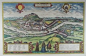
Saltzburgk. Recens et accuratissima Urbis Salisburgensis Delineatio. Altkolorierter Kupferstich aus Braun u. Hogenberg "Civitates Orbis Terrarum" Bd. 3, Köln 1581, 33 x 51 cm
Vendeur : Antiquariat Johannes Müller, Salzburg, Autriche
Membre d'association : ILAB VDAO
Evaluation du vendeur :
Art / Affiche / Gravure
Nebehay-W. 108, 3.Bd. 47 - Fuhrmann, Salzburg in alten Ansichten - Die Stadt Nr. 12 u. Tafel 5.- Sehr schönes, kräftiges Altkolorit.
-
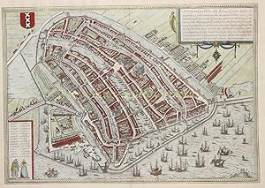
16TH-CENTURY AMSTERDAM "Amstelredamum, Nobile Inferioris Germaniae Oppidum," copper engraving first introduced to the market by Georg Braun and Frans Hogenberg as part of their townbook "Civitates Orbis Terrarum", here in a second edition from 1618-1657
Vendeur : Inter-Antiquariaat Mefferdt & De Jonge, Amsterdam, Pays-Bas
Membre d'association : ILAB NVVA
Evaluation du vendeur :
Art / Affiche / Gravure
16TH-CENTURY AMSTERDAM "Amstelredamum, Nobile Inferioris Germaniae Oppidum," copper engraving first introduced to the market by Georg Braun and Frans Hogenberg as part of their townbook "Civitates Orbis Terrarum", here in a second edition from 1618-1657. Coloured by a later hand. Size (print) approx. 34 x 49 cm. The Civitates Orbis Terrarum was the first townbook ever published. Although it had no true predecessors, the work proved to be in demand as the social, political, and economic life of that period unfolded in the cities. It became one of the bestsellers of the late sixteenth century. The six parts that comprised the work were published between 1572 and 1618; however, only the first part mentions the above title. Georg Braun (1541-1622), canon of the Cologne Cathedral, wrote the preface for the first five volumes and also the accompanying text on the back of the maps and town views. Much of the material for this townbook originated from the Antwerp cartographer Abraham Ortelius, who's Theatrum Orbis Terrarum, first published in 1570, served as a model in several respects for the Civitates. Simon van den Neuvel (Novellanus), Frans Hogenberg, and (his son') Abraham Hogenberg engraved the copperplates based on 'made to order' drawings by, among others, the Antwerp painter Joris Hoefnagel, his son Jacob Hoefnagel, and Heinrich Rantzau. The map of Amsterdam is copied from a map by Cornelisz Anthonisz. from 1544. This was the only available map in the years when the first editions of the Civitates were published. However, in later editions, the publishers had access to a new map of Amsterdam made in 1597 by Pieter Bast. In many cases, as with the map of Amsterdam, the prints were enlivened by adding human figures. This served a dual purpose: not only did it provide the opportunity to show the habits and clothing of the inhabitants, but it also aimed to prevent the Ottomans from using city views during their conquests, as Islam prohibits the depiction of persons. Literature: "Kaarten van Amsterdam 1538-1865," Marc Hameleers, no. 7 (2nd edition). Price: Euro 1,450,-.
-
Civitates Orbis Terrarum. "Burgos. San Sebastian."
Edité par Cologne: T. Graminaeus, 1572-90., 1572
Vendeur : Arader Galleries - AraderNYC, New York, NY, Etats-Unis
Evaluation du vendeur :
Single page (22 x 16 ˝) Full margins showing the plate mark (foxing, browning, margin staining center short tear, chipping, pitting affecting bottom engraving.) A stunning bird s eye view of the Spanish cities of Burgos and San Sebastian. Taken from the 1572 original Civitates Orbis Terrarum by Georg Braun and Frans Hogenberg. This famous atlas provides its viewers with outstanding insight into the cities of the world, through the views, social interactions between locally dressed figures, and pastoral backgrounds. The sheet is further embellished with an elegant bordering and simple cartouches. Burgos is depicted to us as a view from afar, sitting gallantly on the right bank of the Arlazon River. There are several striking architectural structures standing out, namely the enormous Gothic cathedral (13-15c century) towering over the cities structures. In a distance, we see the standing ruins of the old city citadel, which functioned as a fortress for the ruling kings of Castile. The city s commercial activities and trade in cloth, wool, cheese are subtly highlighted by the engraver s staffage. The view of San Sebastian illustrates a delightful seaside-scape, The city s buildings appear cramped and undistinguishable; with the ruins of an old fortress on a nearby hill overlooking the city.The left-hand side outcrop depicted the martyring figure of Saint Sebastian, from whom this city takes its name. The Civitates Orbis Terrarum ( Atlas of the Cities of the World ) by Braun and Hogenburg is the second oldest printed atlas in the history of world cartography; and the first atlas of towns. Its principal creators and authors were the theologist and editor Georg Braun, the most important engraver and publisher Franz Hogenberg. Other artists involved were Simon van den Neuvel, Georg Hoefnagel, Jacob van Deventer to name a few. Although it was published outside of the Netherlands, the Civitates is considered one of the better examples of the Antwerp School of Cartographers, due to its Flemish style of engraving a trait typical of Dutch atlases from the period. One of the most well-known figures from this school, who also played a key role in the making of this atlas, was Abraham Ortelius. It is frequently thought that the Civitates is the direct and intended companion for Ortelius famous Theatrum Orbis Terrarum (1570). In addition to this, there is evidence of correspondence between these three great men and their ideas to create such an atlas. The first volume of the Civitates Orbis Terrarum was published in Cologne in 1572. Its sixth and final volume appeared later in 1617. The Civitates was a widespread and enormously successful. It was frequently republished and supplemented with new sections with later editions. The maps it contained became exemplary and references; thus often reproduced in smaller formats as illustrations for books by other publishers. The atlas bares over 500 maps, representing an entire era in the lavish history of town-mapping. Earlier collections of city views were heterogeneous productions, limited in scope, and often made no meaningful attempt to render the subjects with any degree of realism. The Civitates, by contrast, contained hundreds of views, including many of smaller towns for which no earlier representations are known, depicted with unprecedented accuracy. Braun corresponded extensively with map sellers and scholars from different cities and countries to achieve the highest level of accuracy in his mapping. In addition, the authors also carried out their own investigations, through detailed on-location drawings of panoramic views of the towns made from some high point. It took over forty years to collect the hundreds of plans contained in the Civitates. The plans, each accompanied by Braun's printed account of the town's history, situation and commerce, form a lavish armchair-traveler's compendium, and provide a uniquely comprehensive view of urban life at the turn of the six.
-
Civitates Orbis Terrarum. "Rotomagvs, vulgo Roan, Nor Mandjae Metropolis. Nemavsus Njsmes Civitas Nar Bonensis Galliae Vetust Jssima. Civitatis Bvrdegalensis in Aqvi Tanea, Genvi na de Scrip."
Edité par Cologne: T. Graminaeus, 1572-90., 1572
Vendeur : Arader Galleries - AraderNYC, New York, NY, Etats-Unis
Evaluation du vendeur :
Single page (22 x 16 ˝) Full margins showing the plate mark (foxing, browning, margin staining, chipping) An attractive trio of French cities, namely Rouen, Bordeaux, and Nimes; taken from the Civitates Orbis Terrarum by famed Braun and Hogenberg. The most subtle aspect of these three plans is their Roman roots. Originally parts of Roman provinces, we can frequently see the city walls, amphitheatres, and roads; presented less as backdrops and in as much use here in the 16th century as they were in the Roman era. Rouen held a favorable position, between the right bank of the Seine and the rolling pastoral hills. The staffage suggests the frequent route of trade and travel between Rouen and Paris. Nimes, an old flourishing settlement dating to the Celts, held an important role as capital of the Narbonensis province mid 2nd century. The Via Domitia, a major transportation road linking Italy with Spain, ran right through the city frequently providing the city with ample trade opportunities and visitors. The most regocnizable feature of this plan is the Roman Amphitetheare to the left. Its facacde, made up of two stories and sixty arches, is evident even with the foreshortening. The Pont du Gare, considered one of the most brilliant works of Roman civil engineering, is seen in a distance. In our plan of Bordeaux, it is evident from the size of the city s harbor that it was already an important point of trade between France and the Colonies. The fortifications, seen to the top and bottom left, were built by Charles VII in 15th c. following the King s reconquest of the city. We find a Roman amphitheater sitting in the outskirts of the city emphasizing yet again, Bordeaux s Roman roots. The Civitates Orbis Terrarum ( Atlas of the Cities of the World ) by Braun and Hogenburg is the second oldest printed atlas in the history of world cartography; and the first atlas of towns. Its principal creators and authors were the theologist and editor Georg Braun, the most important engraver and publisher Franz Hogenberg. Other artists involved were Simon van den Neuvel, Georg Hoefnagel, Jacob van Deventer to name a few. Although it was published outside of the Netherlands, the Civitates is considered one of the better examples of the Antwerp School of Cartographers, due to its Flemish style of engraving a trait typical of Dutch atlases from the period. One of the most well-known figures from this school, who also played a key role in the making of this atlas, was Abraham Ortelius. It is frequently thought that the Civitates is the direct and intended companion for Ortelius famous Theatrum Orbis Terrarum (1570). In addition to this, there is evidence of correspondence between these three great men and their ideas to create such an atlas. The first volume of the Civitates Orbis Terrarum was published in Cologne in 1572. Its sixth and final volume appeared later in 1617. The Civitates was a widespread and enormously successful. It was frequently republished and supplemented with new sections with later editions. The maps it contained became exemplary and references; thus often reproduced in smaller formats as illustrations for books by other publishers. The atlas bares over 500 maps, representing an entire era in the lavish history of town-mapping. Earlier collections of city views were heterogeneous productions, limited in scope, and often made no meaningful attempt to render the subjects with any degree of realism. The Civitates, by contrast, contained hundreds of views, including many of smaller towns for which no earlier representations are known, depicted with unprecedented accuracy. Braun corresponded extensively with map sellers and scholars from different cities and countries to achieve the highest level of accuracy in his mapping. In addition, the authors also carried out their own investigations, through detailed on-location drawings of panoramic views of the towns made from some high point. It took over forty y.
-
Civitates Orbis Terrarum. "Leodium"
Edité par Cologne: T. Graminaeus, 1572-90., 1572
Vendeur : Arader Galleries - AraderNYC, New York, NY, Etats-Unis
Evaluation du vendeur :
Single page (22 x 16 ˝) Full margins showing the plate mark (foxing, browning, margin staining, chipping) The magnificently designed engraving of Ličge takes up the rapturous tone of Braun's description and shows the city with the Meuse flowing in its favorable location amongst gentle hills, sturdy trees and fertile fields. Presented in spatial depth and exuding a striking sense of animation, it is one of the most successful landscapes in Braun and Hogenberg's city atlas. In 1468, Ličge was attacked by Charles the Bold and set alight, profoundly altering the medieval face of the city. From the second half of the 15th century onwards much of the city was rebuilt in the contemporary style. The illustration shows the Ourthe flowing into the Meuse and the concentration of buildings in the city centre with its soaring churches and hospices. The cathedral of Saint-Lambert, which would later be destroyed in the upheaval of the French Revolution, is impressively documented. The Gothic collegiate church of Saint-Paul was made Ličge's new cathedral. Examples of Romanesque architecture include the collegiate churches of Saint-Denis, Saint-Barthélemy and the church of Saint-Martin, which was built in the Gothic style in the early 16th century. The Civitates Orbis Terrarum ( Atlas of the Cities of the World ) by Braun and Hogenburg is the second oldest printed atlas in the history of world cartography; and the first atlas of towns. Its principal creators and authors were the theologist and editor Georg Braun, the most important engraver and publisher Franz Hogenberg. Other artists involved were Simon van den Neuvel, Georg Hoefnagel, Jacob van Deventer to name a few. Although it was published outside of the Netherlands, the Civitates is considered one of the better examples of the Antwerp School of Cartographers, due to its Flemish style of engraving a trait typical of Dutch atlases from the period. One of the most well-known figures from this school, who also played a key role in the making of this atlas, was Abraham Ortelius. It is frequently thought that the Civitates is the direct and intended companion for Ortelius famous Theatrum Orbis Terrarum (1570). In addition to this, there is evidence of correspondence between these three great men and their ideas to create such an atlas. The first volume of the Civitates Orbis Terrarum was published in Cologne in 1572. Its sixth and final volume appeared later in 1617. The Civitates was a widespread and enormously successful. It was frequently republished and supplemented with new sections with later editions. The maps it contained became exemplary and references; thus often reproduced in smaller formats as illustrations for books by other publishers. The atlas bares over 500 maps, representing an entire era in the lavish history of town-mapping. Earlier collections of city views were heterogeneous productions, limited in scope, and often made no meaningful attempt to render the subjects with any degree of realism. The Civitates, by contrast, contained hundreds of views, including many of smaller towns for which no earlier representations are known, depicted with unprecedented accuracy. Braun corresponded extensively with map sellers and scholars from different cities and countries to achieve the highest level of accuracy in his mapping. In addition, the authors also carried out their own investigations, through detailed on-location drawings of panoramic views of the towns made from some high point. It took over forty years to collect the hundreds of plans contained in the Civitates. The plans, each accompanied by Braun's printed account of the town's history, situation and commerce, form a lavish armchair-traveler's compendium, and provide a uniquely comprehensive view of urban life at the turn of the sixteenth century. The significance of its being printed in Cologne extends to the city s independence of being a free imperial state. There were few cities which held thi.
-
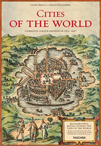
Braun/Hogenberg, Cities of the World - Complete Edition of the Colour Plates 1572-1617 (Civitates Orbis Terrarum)
Edité par Taschen America Llc, 2008
ISBN 10 : 3822852724ISBN 13 : 9783822852729
Livre
Hardcover. Etat : new. New Copy. Customer Service Guaranteed.
-
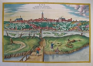
Ens. Austriae civitas superiorem ab inferiore diuidens. Altkolorierter Kupferstich aus Braun und Hogenberg "Civitates Orbis Terrarum" Köln 1617, 33,5 x 49 cm
Vendeur : Antiquariat Johannes Müller, Salzburg, Autriche
Membre d'association : ILAB VDAO
Evaluation du vendeur :
Art / Affiche / Gravure
Nebehay-W. 108, 6.Bd 23.- Schönes breitrandiges Exemplar !.
-
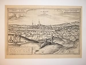
S. Polid vulgo Sanpölten. Inferioris Austriae Civitas". Kupferstich nach Jakob Hoefnagel. Aus: Georg Braun und Franz Hogenberg, Civitates Orbis Terrarum.
Edité par Köln, Selbstverlag, 1572 - 1617., 1572
Vendeur : Matthaeus Truppe Antiquariat, Graz, Autriche
Membre d'association : ILAB VDAO
Evaluation du vendeur :
Art / Affiche / Gravure
Ca. 30 cm x 47 cm. Nebehay-W. 108, 24. - Schöne mit 1617 datierte Ansicht der Stadt St. Pölten aus dem bedeutendsten vor dem Dreissigjährigem Krieg erschienenen Städteatlas. Interessant ist auch die Hinrichtungsszene im rechten Vordergrund. - Gebräunt. *** *** Copyright: Matthaeus TRUPPE Buchhandlung & Antiquariat - Stubenberggasse 7 - A-8010 Graz - ++43 (0)316 - 829552 *** *** Sprache: Deutsch Gewicht in Gramm: 0.
-
Beschreibung und Contrafactur der Vornembster Stat der Welt [ Civitates Orbis Terrarum/ Descriptions and Counterfeits of the World's Most Distinguished Cities ] 1574. 6 volume set.
Edité par Verlag Muller and Schindler., Stuttgart., 1969
Vendeur : Elaine Beardsell, HOLMFIRTH, Royaume-Uni
Membre d'association : PBFA
Evaluation du vendeur :
Livre
Hardcover. Etat : As New. Etat de la jaquette : As New. Limited Edition. Limited edition, number 125 of 300. 6 volumes, folio, double page colour maps and views throughout, full leather gilt, explanatory volume with each slipcase. German text throughout but 4 page ( double column ), English version loosely inserted in Vol 1. As new hardbacks in as new slipcases. NB Very Heavy item, extra postage will be required for none UK orders.
-
48 x 35 cm. Etat : Gut. Erstauflage, EA. 1 Blatt gerahmt hinter Glas mit Passepartout, ohne Rahmen 48 x 35 cm, mit Rahmen 64 x 54 cm, leichter Mittelfalz, guter Zustand Sprache: Deutsch Gewicht in Gramm: 1100.