Montant total (1 article articles) :
Destination de la commande :

clonmell thurles nenagh birr templemore de taylor skinner (5 résultats)
Passer aux résultats principaux de la recherche
Type d'article
- Tous les types d'articles
- Livres
- Magazines & Périodiques
- Bandes dessinées
- Partitions de musique
- Art, Affiches et Gravures
- Photographies
- Cartes (5)
-
Manuscrits &
Papiers anciens
Etat
- Tous
- Neuf
- Ancien ou d'occasion
Reliure
- Toutes
- Couverture rigide
- Couverture souple
Particularités
- Edition originale
- Signé
- Jaquette
- Avec images
- Sans impression ŕ la demande
Pays
Evaluation du vendeur
-
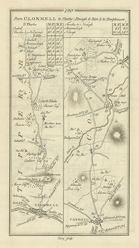
[From Clonmell to Thurles, Nenagh and Birr and to Templemore] // from Birr to Burris-A-Kane
Date d'édition : 1778
Carte
Etat : Good. #192 To Templemore/Birr to Borrisokane. Tipperary Offaly TAYLOR/SKINNER 1778 map. Antique copperplate road map; George Taylor & Andrew Skinner (1778). 23.0 x 13.0cm, 9 x 5 inches. Condition: Good. There is another map printed on the reverse side: #191 From Clonmell to Thurles, Nenagh & Birr [& to Templemore] which includes the towns of Borrisoleigh, Nenagh and covers part of the county of Tipperary. The map includes the towns of Templemore, Birr, Borrisokane and covers part of the counties of Tipperary, Offaly.
-
Etat : Good. #191 Clonmell to Thurles, Nenagh & Birr. Borrisoleigh. TAYLOR/SKINNER 1778 map. Antique copperplate road map; George Taylor & Andrew Skinner (1778). 23.0 x 13.0cm, 9 x 5 inches. Condition: Good. There is another map printed on the reverse side: #192 [From Clonmell to Thurles, Nenagh and Birr and to Templemore] // from Birr to Burris-A-Kane which includes the towns of Templemore, Birr, Borrisokane and covers part of the counties of Tipperary, Offaly. The map includes the towns of Borrisoleigh, Nenagh and covers part of the county of Tipperary.
-
Etat : Good. #190 From Clonmel to Thurles, Nenagh Cashel Tipperary. TAYLOR/SKINNER 1778 map. Antique copperplate road map; George Taylor & Andrew Skinner (1778). 23.0 x 13.0cm, 9 x 5 inches. Condition: Good. There is another map printed on the reverse side: #189 From Limerick to Clonmell and to Cashell which includes the towns of Cashel, Cahir, Golden, Clonmel and covers part of the county of Tipperary. The map includes the towns of Clonmel, Cashel, Thurles and covers part of the county of Tipperary.
-
![Image du vendeur pour From Limerick to Clonmell and to Cashell [and on verso] From Clonmell to Thurles Nenagh & Birr & to Templemore. mis en vente par Robert Frew Ltd. ABA ILAB](https://pictures.abebooks.com/inventory/md/md17237132418.jpg)
From Limerick to Clonmell and to Cashell [and on verso] From Clonmell to Thurles Nenagh & Birr & to Templemore.
Edité par Originally published for the Authors.Sold by T. Longman. London and W. Wilson. Dublin., 1783
Vendeur : Robert Frew Ltd. ABA ILAB, London, Royaume-Uni
Membre d'association : ABA ILAB PBFA
Evaluation du vendeur :

Carte
(25 x 14.5 cm). Uncoloured. Original copper engraved road maps printed in two columns on recto and in two columns on verso. Both sides clean and in good condition.
-
![Image du vendeur pour From Clonmell to Thurles Nenagh & Birr [and on verso] To Templemore Continued from the Last Page [and] From Birr to Burris-a-kane. mis en vente par Robert Frew Ltd. ABA ILAB](https://pictures.abebooks.com/inventory/md/md17237132419.jpg)
From Clonmell to Thurles Nenagh & Birr [and on verso] To Templemore Continued from the Last Page [and] From Birr to Burris-a-kane.
Edité par Originally published for the Authors.Sold by T. Longman. London and W. Wilson. Dublin., 1783
Vendeur : Robert Frew Ltd. ABA ILAB, London, Royaume-Uni
Membre d'association : ABA ILAB PBFA
Evaluation du vendeur :
Carte
(25 x 14.5 cm). Uncoloured. Original copper engraved road maps printed in two columns on recto and in two columns on verso. Both sides clean and in good condition.
![Image du vendeur pour [From Clonmell to Thurles, Nenagh and Birr and to Templemore] // from Birr to Burris-A-Kane mis en vente par Antiqua Print Gallery](https://pictures.abebooks.com/inventory/md/md31423932588.jpg)
![Image du vendeur pour From Clonmell to Thurles, Nenagh & Birr [& to Templemore] mis en vente par Antiqua Print Gallery](https://pictures.abebooks.com/inventory/md/md31423936284.jpg)