Montant total (1 article articles) :
Destination de la commande :

detroit de rand mcnally (56 résultats)
Passer aux résultats principaux de la recherche
Type d'article
- Tous les types d'articles
- Livres (52)
- Magazines & Périodiques
- Bandes dessinées
- Partitions de musique
- Art, Affiches et Gravures
- Photographies
- Cartes (4)
-
Manuscrits &
Papiers anciens
Etat
Reliure
- Toutes
- Couverture rigide
- Couverture souple (19)
Particularités
- Edition originale
- Signé
- Jaquette
- Avec images (9)
- Sans impression ŕ la demande
Pays
Evaluation du vendeur
-

Rand McNally Detroit & Vicinity, Streetfinder
Edité par Rand McNally
ISBN 10 : 0528912615ISBN 13 : 9780528912610
Livre
Paperback. Etat : Good. No Jacket. Pages can have notes/highlighting. Spine may show signs of wear. ~ ThriftBooks: Read More, Spend Less 1.01.
Plus de choix d'achat de la part d'autres vendeurs sur AbeBooks
Offres d'occasion ŕ partir de EUR 7,37
-

Rand McNally Folded Map Detroit and Southeastern Michigan Regional Map
Edité par 0, 2022
ISBN 10 : 0528025457ISBN 13 : 9780528025457
Vendeur : Lakeside Books, Benton Harbor, MI, Etats-Unis
Evaluation du vendeur :

Livre
Etat : New. Brand New! Not Overstocks or Low Quality Book Club Editions! Direct From the Publisher! We're not a giant, faceless warehouse organization! We're a small town bookstore that loves books and loves it's customers! Buy from Lakeside Books!.
Plus de choix d'achat de la part d'autres vendeurs sur AbeBooks
Offres neuf ŕ partir de EUR 6,58
Offres d'occasion ŕ partir de EUR 16,91
Trouvez également Couverture souple
-

Hallwag USA Road Guide, No.3, Great Lakes: Area and City Maps. National Parks. Highlights: Chicago, Detroit, Niagara Falls, Isle Royale. Straßenkarte, . Index. (Rand McNally) (USA Road Guides)
Edité par Hallwag Maps, 2005
ISBN 10 : 3828302823ISBN 13 : 9783828302822
Livre
Befriedigend/Good: Durchschnittlich erhaltenes Buch bzw. Schutzumschlag mit Gebrauchsspuren, aber vollständigen Seiten. / Describes the average WORN book or dust jacket that has all the pages present.
-

Rand McNally Folded Map: Detroit Street Map
Edité par Rand McNally, 2022
ISBN 10 : 0528024922ISBN 13 : 9780528024924
Livre
Etat : Good. Book is in Used-Good condition. Pages and cover are clean and intact. Used items may not include supplementary materials such as CDs or access codes. May show signs of minor shelf wear and contain limited notes and highlighting.
Plus de choix d'achat de la part d'autres vendeurs sur AbeBooks
Offres neuf ŕ partir de EUR 23,54
Offres d'occasion ŕ partir de EUR 19,90
-
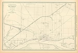
Rand, McNally & Co's Map of the Main Portion of Detroit
Edité par Rand, McNally & Company, Chicago, 1898
Vendeur : Stephen Peterson, Bookseller, Eden Prairie, MN, Etats-Unis
Evaluation du vendeur :
Carte
No Binding. Etat : Good. Good, 14" X 11" map with slight yellowing, light soiling, and light edgewear.
-
Etat : Good. Detroit town city map plan. Michigan. RAND MCNALLY 1906 old antique chart. Antique colour (color) city plan; Rand McNally (1906). 27.5 x 33.5cm, 10.75 x 13.25 inches. Condition: Good. There are images and/or text printed on the reverse side of the picture. In some cases this may be visible on the picture itself or around the margin of the picture.
-

Rand Mcnally Detroit Metro Street Guide
Edité par Rand McNally, 2007
ISBN 10 : 0528867032ISBN 13 : 9780528867033
Livre
paperback. Etat : Good.
-

Paperback. Etat : Good. No Jacket. Pages can have notes/highlighting. Spine may show signs of wear. ~ ThriftBooks: Read More, Spend Less 2.75.
-

Rand Mcnally Indexed Pocket Map Tourists' And Shippers' Guide Of Illinois The Standard Accident Insurance Company Of Detroit
Edité par Rand Mcnally & Co, Chicago, 1920
Vendeur : Attic Treasures Book Shop, Mt. Carmel, IL, Etats-Unis
Evaluation du vendeur :

Livre
Soft cover. Etat : Fair. No Jacket. Thomas Derrick (illustrateur). 75 Pages With Ads On Pages In Rear Of Book. Staple Binding; Pages Tight; Yellowed; Moderate Page Wear. Page Edges Darkened. No Markings; Beige Soft Covers With Black Lettering And Border On Front Cover; Ad For Shaving Lather On Back Cover. Small Tears On Spine Near Staples. Contains Guide For Railroads, Electric Lines, Post Offices, Express Telegraph And Mail Service. Also Alphabetical List Of Counties, Congressional Townships, Cities, Towns, Villages, Rivers, Lakes, Islands, Creeks, Etc.; Population According To The Latest Official Census And Main Highways. Very Rare Vintage Copy.
-
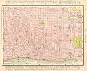
Detroit
Date d'édition : 1895
Vendeur : Art Source International Inc., Boulder, CO, Etats-Unis
Evaluation du vendeur :
This map comes from the Rand McNally Universal Atlas printed in 1895. This detailed map of Detroit shows the main portion of the city This map measures 9.25 inches by 12.5 inches.
-

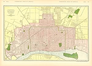
McNally's 1928 Map of Detroit, Michigan
Vendeur : Art Source International Inc., Boulder, CO, Etats-Unis
Evaluation du vendeur :
This map was produced by Rand McNally and Co. as part of its 1928 Commercial Atlas of America. These maps are some of our favorite maps because of the large size of each map sheet. The detail shown on each map is exceptional because of the map size. These maps were intended to be used by business for shipping and other uses. Roads, railroads, rivers, and buildings are clearly shown. There is more detail on these maps than any others during this time period.This map measures approximately 7.25 by 8.25 inches.
-
McNally's 1919 Map of Detroit
Date d'édition : 1919
Vendeur : Art Source International Inc., Boulder, CO, Etats-Unis
Evaluation du vendeur :
We are proud to offer this wonderful large scale map originally issued as part of Rand McNally's Commercial Atlas of America in 1919. The maps from this atlas were larger than most atlas' published at the time and show many more cities and towns. All railroad lines were drawn in red and numbered with a listing of all railroads operating in the area on each map. William H. Rand founded the company in 1856 and incorporated it in 1873 with his partner Andrew McNally. They published their first atlas, The Business Atlas, in 1877. Rand McNally and Company is the oldest business of its kind in the country. This map measures inches by inches.
-
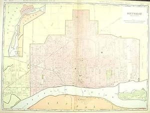
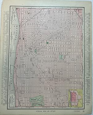
Detroit
Date d'édition : 1908
Vendeur : Art Source International Inc., Boulder, CO, Etats-Unis
Evaluation du vendeur :
This large format map was published in Rand McNally & Co.s Indexed Atlas of the World, dated 1908. This detailed city map shows, buildings, streets, parks, rail lines, and many other details. A neat glimpse of the city in the early 20th century.This map measures 19 inches by 26 inches.
-
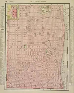
McNally's 1915 Map of Detroit
Date d'édition : 1915
Vendeur : Art Source International Inc., Boulder, CO, Etats-Unis
Evaluation du vendeur :
This map of Detroit was produced by Rand McNally and Co. as part of its Commercial Atlas of America. These maps are some of our favorite maps because of the large size of each map. The detail shown on each map is exceptional because of the map size. These maps were intended to be used by business for shipping and other uses. Roads, railroads, rivers, and buildings are clearly shown. There is more detail on these maps than any others during this time period. This map measures 19 inches by 25.5 inches.
-

McNally's 1902 Map of Detroit
Date d'édition : 1902
Vendeur : Art Source International Inc., Boulder, CO, Etats-Unis
Evaluation du vendeur :
We are proud to offer this wonderful large scale map originally issues as part of Rand, McNally's Enlarged Business Atlas and Shippers Guide, Showing in Detail the Entire Railroad System in 1902. The maps from this atlas were larger than most atlas' published at the time and show many more cities and towns. All railroad lines were drawn in red and numbered with a listing of all railroads operating in the state on each map. William H. Rand founded the company in 1856 and incorporated it in 1873 with his partner Andrew McNally. They published their first atlas, The Business Atlas, in 1877. Rand McNally and Company is the oldest business of its kind in the country. This map measures 19 inches by 27.25 inches.
-

Rand McNally Detroit Metro, Michigan: Street Guide (Rand Mcnally Street Guide)
Edité par Rand McNally, 2005
ISBN 10 : 0528855042ISBN 13 : 9780528855047
Livre
Etat : Sehr gut. 5. 0 2058858/1 Altersfreigabe FSK ab 0 Jahre Taschenbuch, Größe: 23.5 x 2.5 x 27.3 cm.
Plus de choix d'achat de la part d'autres vendeurs sur AbeBooks
Offres neuf ŕ partir de EUR 185,98
Offres d'occasion ŕ partir de EUR 112,20
Trouvez également Couverture souple
-

Rand McNally Detroit Wayne County Streetfinder
Edité par Rand McNally, 1997
ISBN 10 : 0528969471ISBN 13 : 9780528969478
Livre
Paperback. Etat : new. New Copy. Customer Service Guaranteed.
Plus de choix d'achat de la part d'autres vendeurs sur AbeBooks
Offres neuf ŕ partir de EUR 242,62
-

Rand McNally Folded Map: Detroit and Southeastern Michigan Regional Map
Edité par Rand McNally, 2019
ISBN 10 : 052800798XISBN 13 : 9780528007989
Livre
Etat : Good. Item in good condition. Textbooks may not include supplemental items i.e. CDs, access codes etc.
Plus de choix d'achat de la part d'autres vendeurs sur AbeBooks
Offres neuf ŕ partir de EUR 772,07
Offres d'occasion ŕ partir de EUR 287,60
Trouvez également Couverture souple