Montant total (1 article articles) :
Destination de la commande :

duche savoye comprend chablais fossigny de vaugondy robert didier (6 rťsultats)
Passer aux rťsultats principaux de la recherche
Type d'article
- Tous les types d'articles
- Livres
- Magazines & Pťriodiques
- Bandes dessinťes
- Partitions de musique
- Art, Affiches et Gravures
- Photographies
- Cartes (6)
-
Manuscrits &
Papiers anciens
Etat
- Tous
- Neuf
- Ancien ou d'occasion
Reliure
- Toutes
- Couverture rigide
- Couverture souple
Particularitťs
- Edition originale
- Signť
- Jaquette
- Avec images
- Sans impression ŗ la demande
Pays
Evaluation du vendeur
-
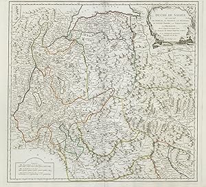
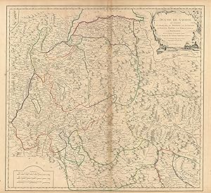
Duche de Savoie qui comprend le Chablais, le Fossigny, le Genevois, la Savoye Propre, la Tarentaise et la Maurienne dressť d'apres la Grande Carte de Piemon de Tomaso Borgomo et andres." - Savoia Savoie Savoyen Aosta Karte map carta incisione gravure
Editť par Paris, 1751
Vendeur : Antiquariat Steffen VŲlkel GmbH, Seubersdorf, Allemagne
Membre d'association : ILAB VDA
Evaluation du vendeur :

Carte
GroŖformatige handkolorierte originalKupferstich-Kartevon 1751. - Blattmasse: ca. 51 x 67 cm. -- gut erhalten. || Large handcolored original engraved map from 1751. -- in good condition. || Dies ist ein Original! - Kein Nachdruck! - Keine Kopie! -- This is an original! No copy! - No reprint! Sprache: FranzŲsisch Gewicht in Gramm: 1550.
-
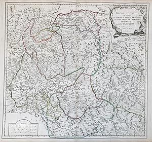
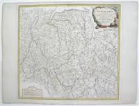
Duche de Savoie qui comprend le Chablais, le Fossigny, le Genevois, la Savoye Propre, la Tarentaise et la Maurienne dressť d'apres la Grande Carte de Piemon de Tomaso Borgomo et andres." - Savoia Savoie Savoyen Aosta Karte map carta incisione gravure
Editť par Paris ca. 1750., 1750
Vendeur : Antiquariat Steffen VŲlkel GmbH, Seubersdorf, Allemagne
Membre d'association : ILAB VDA
Evaluation du vendeur :
Carte
Altkolorierte Kupferstich-Kartevon ca. 1750 - Blattmasse: ca. 51 x 67 cm -- im Mittelbug leicht gebršunt, sonst gut erhalten. || Old colored engraved map from ca. 1750 - slightly browned on the centerfold, otherwise in good condition. Sprache: FranzŲsisch Gewicht in Gramm: 35.
-
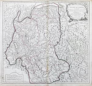
Duchť de Savoye qui comprend le Chablais, le Fossigny, le Genevois, la Savoye Propre, La Tarentaise et la Maurienne" - Savoia Savoie Savoy Geneva Annecy Chambery Cluses Aosta Martigny Moutiers Lac Leman carte gravure
Editť par Venezia, Santini & Remondini, 1778
Vendeur : Antiquariat Steffen VŲlkel GmbH, Seubersdorf, Allemagne
Membre d'association : ILAB VDA
Evaluation du vendeur :
Carte
GroŖformatige altkolorierte Kupferstich-Karte von 1778. -- Blatt-MaŖe: ca. 52 x 74 cm. -- sehr gut erhalten. || Large old colored engraved map from 1778. -- in very good condition. || Francesco Santini was a Venetian publisher. He acquired the printing plates of Vaugondy's Atlas Universel, a commercial and cartographic success, with widespread influence on mapmakers throughout Europe. Together with his brother Paolo, he commissioned a new set of plates and reissued the atlas in 1776. In the following years, Paolo Santini assigned all his publication rights to M. Remondini, who in 1777 reissued the same atlas, but with his name. || Dies ist ein Original! - Kein Nachdruck! - Keine Kopie! -- This is an original! - No copy! - No reprint! Sprache: FranzŲsisch Gewicht in Gramm: 550.
-
Etat : Good. "Duchť de Savoye " Duchy of Savoie. French Alps. Aosta. VAUGONDY 1751 old map. Large antique 18th century atlas map, printed on thick, good quality paper with original outline hand colour/color and decorative title cartouche; Robert de Vaugondy, Gilles & Didier (1751). 49.5 x 54.5cm, 19.5 x 21.5 inches; this is a folding map. Condition: Good. Please contact us if you would like to arrange to view this map. There is nothing printed on the reverse side, which is plain.".
-
Etat : Good. "Duchť de Savoye " Duchy of Savoie. Aosta & French Alps. VAUGONDY 1751 old map. Large antique 18th century atlas map, printed on thick, good quality paper with original outline hand colour/color and decorative title cartouche; Robert de Vaugondy, Gilles & Didier (1751). 50.0 x 55.0cm, 19.75 x 21.5 inches; this is a folding map. Condition: Good. Please contact us if you would like to arrange to view this map. There is nothing printed on the reverse side, which is plain.".
-
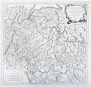
Duche de Savoye qui comprend Le Chablais, le Fossigny, le Genevois, la Savoye Propre, la Tareentaise et la Maurienne
Editť par Paris, 1760
Vendeur : Alexandre Antique Prints, Maps & Books, Toronto, ON, Canada
Membre d'association : ABAC ILAB
Evaluation du vendeur :

Carte
Etat : Excellent. Size : 502x540 (mm), 19.75x21.25 (Inches), Original Outline Coloring.