
Montant total (1 article articles) :
Destination de la commande :

environs dublin de society diffusion useful knowledge (5 résultats)
Passer aux résultats principaux de la recherche
Filtres de recherche
Type d'article
- Tous les types de produits
- Livres (3)
- Magazines & Périodiques (Aucun autre résultat ne correspond ŕ ces critčres)
- Bandes dessinées (Aucun autre résultat ne correspond ŕ ces critčres)
- Partitions de musique (Aucun autre résultat ne correspond ŕ ces critčres)
- Art, Affiches et Gravures (1)
- Photographies (Aucun autre résultat ne correspond ŕ ces critčres)
- Cartes (1)
- Manuscrits & Papiers anciens (Aucun autre résultat ne correspond ŕ ces critčres)
Etat En savoir plus
- Neuf (Aucun autre résultat ne correspond ŕ ces critčres)
- Comme neuf, Trčs bon ou Bon (1)
- Assez bon ou satisfaisant (1)
- Moyen ou mauvais (Aucun autre résultat ne correspond ŕ ces critčres)
- Conformément ŕ la description (3)
Reliure
- Toutes
- Couverture rigide (Aucun autre résultat ne correspond ŕ ces critčres)
- Couverture souple (Aucun autre résultat ne correspond ŕ ces critčres)
Particularités
- Ed. originale (Aucun autre résultat ne correspond ŕ ces critčres)
- Signé (Aucun autre résultat ne correspond ŕ ces critčres)
- Jaquette (Aucun autre résultat ne correspond ŕ ces critčres)
- Avec images (5)
- Sans impressions ŕ la demande (5)
Langue (1)
Prix
- Tous les prix
- Moins de EUR 20 (Aucun autre résultat ne correspond ŕ ces critčres)
- EUR 20 ŕ EUR 45
- Plus de EUR 45
Livraison gratuite
- Livraison gratuite ŕ destination de Etats-Unis (Aucun autre résultat ne correspond ŕ ces critčres)
Pays
Evaluation du vendeur
-

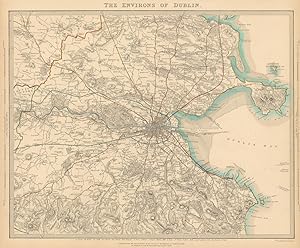
The Environs of Dublin.
Edité par London, Baldwin & Cradock, 1837. 335 x 400mm (13Ľ x 15ľ inches)., 1837
Vendeur : Tooley, Adams & Co., Wallingford, OXON, Royaume-Uni
Évaluation du vendeur 5 sur 5 étoiles

EUR 32,72
EUR 42,14 expédition depuis Royaume-Uni vers Etats-UnisQuantité disponible : 1 disponible(s)
Ajouter au panierOriginal outline colour; light age-toning to the edges of the margins, light soiling, otherwise a very good example. An early Victorian map of Dublin and the environs, drawn and engraved by B.R.Davies. From the 1844 edition published by Chapman & Hall, for The Society for the Diffusion of Useful Knowledge.
-

The Environs of Dublin.
Edité par London, Thomas Letts, [1877]. 335 x 400mm (13Ľ x 15ľ inches)., 1877
Vendeur : Tooley, Adams & Co., Wallingford, OXON, Royaume-Uni
Évaluation du vendeur 5 sur 5 étoiles
EUR 42,06
EUR 42,14 expédition depuis Royaume-Uni vers Etats-UnisQuantité disponible : 1 disponible(s)
Ajouter au panierOriginal outline colour; very light age-toning to the edges of the margins, otherwise a fine example. A Victorian map of Dublin and the environs, drawn and engraved by B.R.Davies. From the 1877 edition published by Thomas Letts for The Society for the Diffusion of Useful Knowledge.
-

Map of the Environs of Dublin, Ireland
Edité par London, 1857
Vendeur : Trillium Antique Prints & Rare Books, Franklin, TN, Etats-Unis
Évaluation du vendeur 4 sur 5 étoiles

Art / Affiche / Gravure
EUR 199,88
EUR 8,62 expédition vers Etats-UnisQuantité disponible : 1 disponible(s)
Ajouter au panierEtat : Fine. This originally hand-colored engraving is from "The Complete Atlas of Modern, Classical and Celestial Maps, together with Plans of the Principal Cities of the World". The work was published in 1857 by Edward Stanford for the Society for the Diffusion of Useful Knowledge. --- The work is in very good to excellent condition. There may be a few minor imperfections to be expected with age. Please review the image carefully for condition and contact us with any questions. --- Paper Size ~ 14" by 16 7/8".
-

THE ENVIRONS OF DUBLIN
Vendeur : Antiqua Print Gallery, London, Royaume-Uni
Évaluation du vendeur 3 sur 5 étoiles

EUR 268,74
EUR 11,34 expédition depuis Royaume-Uni vers Etats-UnisQuantité disponible : 1 disponible(s)
Ajouter au panier -
THE ENVIRONS OF DUBLIN
Date d'édition : 1844
Vendeur : Antiqua Print Gallery, London, Royaume-Uni
Évaluation du vendeur 3 sur 5 étoiles
Carte
EUR 303,79
EUR 11,34 expédition depuis Royaume-Uni vers Etats-UnisQuantité disponible : 1 disponible(s)
Ajouter au panierEtat : Good. IRELAND. The environs of Dublin. SDUK 1844 old antique vintage map plan chart. Antique steel engraved map with original hand colouring (color); Engraved by BR Davies (This map was originally published by Baldwin & Cradock in 1837; this date is printed on the map. This edition of the map was printed and published by Chapman & Hall in 1844.). 33.5 x 40.5cm, 13 x 16 inches. Condition: Good. The image shown may have been taken from a different example of this map than that which is offered for sale. The map you will receive is in good condition but there may be minor variations in the condition from that shown in the image. This map was coloured by hand at the time of publication, thus the colouration may vary slightly between different examples of the map; the colouring applied to the map you receive may differ slightly from that shown in the image. There is nothing printed on the reverse side, which is plain.