
Montant total (1 article articles) :
Destination de la commande :

ierusalem niewlicks uyt schriften iosephus de johannes cocceius mortier (1 résultats)
Passer aux résultats principaux de la recherche
Type d'article
- Tous les types d'articles
- Livres
- Magazines & Périodiques
- Bandes dessinées
- Partitions de musique
- Art, Affiches et Gravures
- Photographies
- Cartes (1)
-
Manuscrits &
Papiers anciens
Etat
- Tous
- Neuf
- Ancien ou d'occasion
Reliure
- Toutes
- Couverture rigide
- Couverture souple
Particularités
- Edition originale
- Signé
- Jaquette
- Avec images
- Sans impression ŕ la demande
Pays
Evaluation du vendeur
-
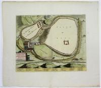
Ierusalem niewlicks uyt de Schriften Iosephus
Edité par c.1722, Amsterdam, 1722
Vendeur : Alexandre Antique Prints, Maps & Books, Toronto, ON, Canada
Membre d'association : ABAC ILAB
Evaluation du vendeur :

Carte
Etat : Very Good. Map of Jerusalem according to first-century Jewish historian Josephus. With Dutch text indicating locations of major features of the city such as temples, palaces, and gates, and the site of Golgotha is located in the image's upper register. , Size : 330x400 (mm), 13x15.75 (Inches), Hand Colored.