Montant total (1 article articles) :
Destination de la commande :

indiana de rand mcnally (102 résultats)
Passer aux résultats principaux de la recherche
Type d'article
- Tous les types d'articles
- Livres (96)
- Magazines & Périodiques
- Bandes dessinées
- Partitions de musique
- Art, Affiches et Gravures (2)
- Photographies
- Cartes (4)
-
Manuscrits &
Papiers anciens
Etat
Reliure
Particularités
Pays
Evaluation du vendeur
-

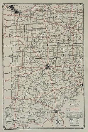
Rand McNally Indiana (Easy to Fold)
Edité par Rand McNally (edition ), 2016
ISBN 10 : 0528994794ISBN 13 : 9780528994791
Livre
Paperback. Etat : Good. Ship within 24hrs. Satisfaction 100% guaranteed. APO/FPO addresses supported.
Plus de choix d'achat de la part d'autres vendeurs sur AbeBooks
Offres neuf ŕ partir de EUR 22,37
Offres d'occasion ŕ partir de EUR 7,79
Trouvez également Couverture souple
-

Rand McNally Easy to Fold: Indiana State Laminated Map (Sheet Map, Folded)
Edité par Rand McNally 3/4/2022, 2022
ISBN 10 : 0528026046ISBN 13 : 9780528026041
Vendeur : BargainBookStores, Grand Rapids, MI, Etats-Unis
Evaluation du vendeur :

Livre
Sheet Map, Folded. Etat : New. Rand McNally Easy to Fold: Indiana State Laminated Map 0.25. Book.
Plus de choix d'achat de la part d'autres vendeurs sur AbeBooks
Offres neuf ŕ partir de EUR 9,99
-

McDougal Littell World Cultures & Geography Indiana: Teacher Editon Grades 6-8 Western Hemisphere and Europe 2003
Edité par McDougal Littell, 2003
ISBN 10 : 0395734878ISBN 13 : 9780395734872
Livre
hardcover. Etat : Good. Connecting readers with great books since 1972! Used textbooks may not include companion materials such as access codes, etc. May have some wear or writing/highlighting. We ship orders daily and Customer Service is our top priority!.
Plus de choix d'achat de la part d'autres vendeurs sur AbeBooks
Offres d'occasion ŕ partir de EUR 6,72
-

Rand McNally Easy to Read: Indiana State Map
Edité par Rand McNally, 2024
ISBN 10 : 0528027875ISBN 13 : 9780528027871
Vendeur : Lakeside Books, Benton Harbor, MI, Etats-Unis
Evaluation du vendeur :
Livre
Etat : New. Brand New! Not Overstocks or Low Quality Book Club Editions! Direct From the Publisher! We're not a giant, faceless warehouse organization! We're a small town bookstore that loves books and loves it's customers! Buy from Lakeside Books!.
Plus de choix d'achat de la part d'autres vendeurs sur AbeBooks
Offres neuf ŕ partir de EUR 7,72
-

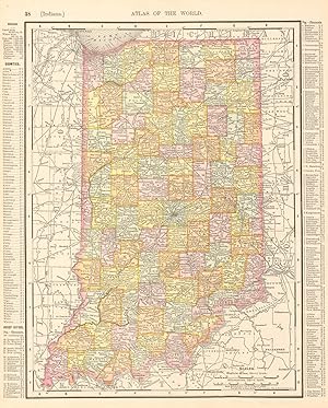
MAP: 'Indiana'.from Rand McNally's Dollar Atlas of the World
Edité par Rand McNally & Co, Chicago IL, 1916
Vendeur : Dorley House Books, Inc., Hagerstown, MD, Etats-Unis
Evaluation du vendeur :

Art / Affiche / Gravure
Unbound. Etat : Very Good. Colored Map (illustrateur). 5.5" x 7'' map, suitable for framing Size: 5.5" x 7''.
-

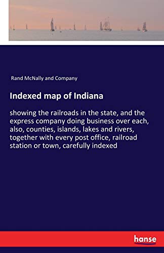
Indexed Map of Indiana: Showing the Railroads in the State, and the Express Company Doing Business Over Each, Also, Counties, Islands, Lakes a (Paperback or Softback)
Edité par Legare Street Press 7/18/2023, 2023
ISBN 10 : 1021794678ISBN 13 : 9781021794673
Vendeur : BargainBookStores, Grand Rapids, MI, Etats-Unis
Evaluation du vendeur :
Livre
Paperback or Softback. Etat : New. Indexed Map of Indiana: Showing the Railroads in the State, and the Express Company Doing Business Over Each, Also, Counties, Islands, Lakes a 0.23. Book.
Plus de choix d'achat de la part d'autres vendeurs sur AbeBooks
Offres neuf ŕ partir de EUR 17,94
-

Easy To Read: Indiana State Map
Edité par Rand McNally, 2016
ISBN 10 : 0528881248ISBN 13 : 9780528881244
Livre
Etat : Good. Item in good condition. Textbooks may not include supplemental items i.e. CDs, access codes etc.
Plus de choix d'achat de la part d'autres vendeurs sur AbeBooks
Offres neuf ŕ partir de EUR 26,50
Offres d'occasion ŕ partir de EUR 18,27
Trouvez également Couverture souple
-
Rand, McNally and Co. 'S Indexed Map of Indiana (Classic Reprint)
Edité par Forgotten Books, 2018
ISBN 10 : 0243107587ISBN 13 : 9780243107582
Livre impression ŕ la demande
Paperback. Etat : New. Print on Demand. Excerpt from Rand, McNally and Co. 'S Indexed Map of Indiana. About the Publisher, Forgotten Books publishes hundreds of thousands of rare and classic books. This book is a reproduction of an important historical work. Forgotten Books uses state-of-the-art technology to digitally reconstruct the work, preserving the original format whilst repairing imperfections present in the aged copy. In rare cases, an imperfection in the original, such as a blemish or missing page, may be replicated in our edition. We do, however, repair the vast majority of imperfections successfully; any imperfections that remain are intentionally left to preserve the state of such historical works. This text has been digitally restored from a historical edition. Some errors may persist, however we consider it worth publishing due to the work's historical value. The digital edition of all books may be viewed on our website before purchase. print-on-demand item.
Plus de choix d'achat de la part d'autres vendeurs sur AbeBooks
Offres neuf ŕ partir de EUR 14,48
-

Delorme Atlas & Gazetteer: Indiana
Edité par Delorme Mapping Company 11/1/2023, 2023
ISBN 10 : 1946494518ISBN 13 : 9781946494511
Vendeur : BargainBookStores, Grand Rapids, MI, Etats-Unis
Evaluation du vendeur :
Livre
Other Cartographic. Etat : New. Delorme Atlas & Gazetteer: Indiana 0.85. Book.
Plus de choix d'achat de la part d'autres vendeurs sur AbeBooks
Offres neuf ŕ partir de EUR 22,71
-
Etat : Good. Indiana state map showing counties. RAND MCNALLY 1906 old antique chart. Antique colour (color) atlas map; Rand McNally (1906). 34.0 x 27.0cm, 13.25 x 10.75 inches. Condition: Good. There are images and/or text printed on the reverse side of the picture. In some cases this may be visible on the picture itself or around the margin of the picture.
-
Indexed map of Indiana:showing the railroads in the state; and the express company doing business over each; also; counties; islands; lakes and rivers; together with every post office; railroad statio
Edité par Hansebooks, 2017
ISBN 10 : 3337368662ISBN 13 : 9783337368661
Vendeur : Ria Christie Collections, Uxbridge, Royaume-Uni
Evaluation du vendeur :
Livre impression ŕ la demande
Etat : New. PRINT ON DEMAND Book; New; Fast Shipping from the UK. No. book.
Plus de choix d'achat de la part d'autres vendeurs sur AbeBooks
Offres neuf ŕ partir de EUR 19,58
-

Rand, McNally and Co 'S Indexed Map of Indiana Showing the Railroads in the State, and the Express Company Doing Business Over Each, Also, Counties, Townships, Lakes and Rivers Classic Reprint
Edité par Forgotten Books, 2018
ISBN 10 : 0666711801ISBN 13 : 9780666711809
Livre
HRD. Etat : New. New Book. Shipped from UK. Established seller since 2000.
Plus de choix d'achat de la part d'autres vendeurs sur AbeBooks
Offres neuf ŕ partir de EUR 31,35
-
![Image du vendeur pour Indexed map of Indiana : showing the railroads in the state, and the express company doing business over each, also, counties, islands, lakes and rivers, together with every post office, railroad station or town, carefully indexed, referring to the exact location where each may be found on the map [LeatherBound] mis en vente par True World of Books](https://pictures.abebooks.com/inventory/md/md31533332700.jpg)
Indexed map of Indiana : showing the railroads in the state, and the express company doing business over each, also, counties, islands, lakes and rivers, together with every post office, railroad station or town, carefully indexed, referring to the exact location where each may be found on the map [LeatherBound]
Date d'édition : 2023
Livre impression ŕ la demande
LeatherBound. Etat : New. LeatherBound edition. Condition: New. Reprinted from 1880 edition. Leather Binding on Spine and Corners with Golden leaf printing on spine. Bound in genuine leather with Satin ribbon page markers and Spine with raised gilt bands. A perfect gift for your loved ones. NO changes have been made to the original text. This is NOT a retyped or an ocr'd reprint. Illustrations, Index, if any, are included in black and white. Each page is checked manually before printing. As this print on demand book is reprinted from a very old book, there could be some missing or flawed pages, but we always try to make the book as complete as possible. Fold-outs, if any, are not part of the book. If the original book was published in multiple volumes then this reprint is of only one volume, not the whole set. Sewing binding for longer life, where the book block is actually sewn (smythe sewn/section sewn) with thread before binding which results in a more durable type of binding. Pages: 65 Language: English.
-

Map of Indiana
Date d'édition : 1885
Vendeur : Art Source International Inc., Boulder, CO, Etats-Unis
Evaluation du vendeur :

With the 19th century innovations of publishing and technology, the world became a smaller place and one which anyone could become acquainted with. As these changes blossomed, the fledgling company of Rand McNally realized the interest in small accessible material, and produced a pocket atlas. These maps carry handy reference information, and were up to date for the period. They include cities, some towns as well as some roads. They have their own charm and would be great for framing, and decorative use. This map measures 5 inches by 3 inches.
-
Map of Indiana
Date d'édition : 1887
Vendeur : Art Source International Inc., Boulder, CO, Etats-Unis
Evaluation du vendeur :
With the 19th century innovations of publishing and technology, the world became a smaller place and one which anyone could become acquainted with. As these changes blossomed, the fledgling company of Rand McNally realized the interest in small accessible material, and produced a pocket atlas. These maps carry handy reference information, and were up to date for the period. They include cities, some towns as well as some roads. They have their own charm and would be great for framing, and decorative use. This map measures 5 inches by 3 inches.
-
Map of Indianapolis, Indiana
Date d'édition : 1921
Vendeur : Art Source International Inc., Boulder, CO, Etats-Unis
Evaluation du vendeur :
This black and white map of Indianapolis was made by Rand McNally in 1921. The very detailed map has identification of sections of the city, important buildings and landmarks, railroad lines, and major roads. This map measures 19 inches by 12.5 inches.
-
Rand McNally Black and White Milage Map of Indiana
Date d'édition : 1921
Vendeur : Art Source International Inc., Boulder, CO, Etats-Unis
Evaluation du vendeur :
This black and white Rand McNally mileage map of Indiana was made in 1921. Cities, important towns, counties, railroad lines, highways, and distances between major towns are identified. This map measures 19 inches by 12.5 inches.
-

State of Indiana
Date d'édition : 1884
Vendeur : Art Source International Inc., Boulder, CO, Etats-Unis
Evaluation du vendeur :
This handsome map of Indiana, combines some of the best features of Rand McNally's accuracy, simplicity and attractive presentation, all in a smaller format. With the benefit of the latest information of the time, this map details of towns, cities, railroads and boundaries of this area, and would rival many larger publications. Condition of this map is good, with bold printed color. An uncommon map. This map measures 6.5 inches by 4.5 inches.
-
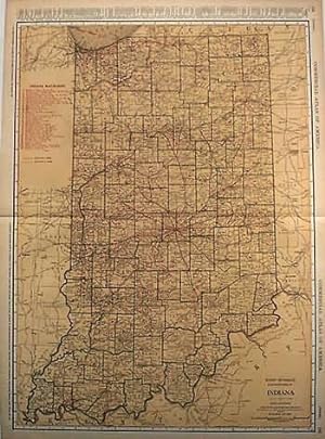
Rand McNally Junior Auto Road Map of Indiana
Date d'édition : 1930
Vendeur : Art Source International Inc., Boulder, CO, Etats-Unis
Evaluation du vendeur :
Edition originale
Rand McNally & Company, still a major name in map publishing to this day, began as a small print shop opened in Chicago in 1856 by William H. Rand. The shop originally printed guidebooks and directories. In 1858, Rand hired Andrew McNally who was later to become a partner. Within the next few years, the shop got into the railroad business by starting to print railway tickets and schedules, a key step in the development of the company. The ticket printing led to the publishing of railway guides, and by 1872 Rand McNally and Company had the capacity to publish maps. This road map of Indiana came from Rand McNallys Commercial Atlas, sixty-first Edition dated 1930. A highly successful run of atlases that lasted over a decade. This map includes a detailed plan of all existing highways (in red) and all other roads in existance at the time. This map measures 17 inches by 11 inches.
-

Indexed Map of Indiana: Showing the Railroads in the State, and the Express Company Doing Business Over Each, Also, Counties, Islands, Lakes and Rivers, Together With Every Post Office, Railroad Station or Town, Carefully Indexed, Referring to The.
Edité par Legare Street Press, 2023
ISBN 10 : 101975298XISBN 13 : 9781019752982
Livre impression ŕ la demande
Hardback. Etat : New. This item is printed on demand. New copy - Usually dispatched within 5-9 working days.
-

Fourth Annual Report of the Old People's Home, Indiana Avenue and Thirty-ninth Street. Chicago, Ill., for the Year Ending May, 1877
Edité par Chicago: Rand, McNally & Co, 1877
Vendeur : Zubal-Books, Since 1961, Cleveland, OH, Etats-Unis
Evaluation du vendeur :
Etat : Very Good. 24 pp., original paper wrappers, near very good. - If you are reading this, this item is actually (physically) in our stock and ready for shipment once ordered. We are not bookjackers. Buyer is responsible for any additional duties, taxes, or fees required by recipient's country.
-
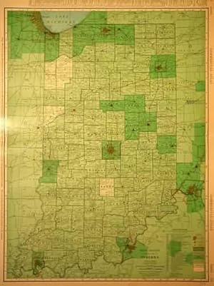
Indiana
Date d'édition : 1921
Vendeur : Art Source International Inc., Boulder, CO, Etats-Unis
Evaluation du vendeur :
Rand McNally & Co. made this large scale map of Indiana in 1921. This map is fully colored in light tan with green outline coloring of counties. Red numbers represent railroad lines identified in a key. The names of counties, important cities, lakes and rivers are shown. This map measures 26 inches by 19 inches.
-

Indiana
Date d'édition : 1895
Vendeur : Art Source International Inc., Boulder, CO, Etats-Unis
Evaluation du vendeur :
This map is from the Rand McNally Universal Atlas printed in 1895. Nebraska is shown here in detail, including rivers, lakes, mountains, counties, important cities, and indian reservations. The concentration of the population to the eastern side of the state at this time is evident here. This map measures 12.5 inches by 9.25 inches.
-
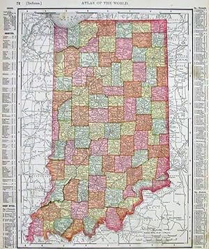
Indiana
Date d'édition : 1902
Vendeur : Art Source International Inc., Boulder, CO, Etats-Unis
Evaluation du vendeur :
This detailed map was originally published in Rand, McNally & Co.s Universal Atlas of The World. From its beginnings as a small Chicago printing shop in 1856, Rand McNally & Company launched a 146-year continuing journey that has led the company to its place as the world's premier provider of geographic and travel information. This colorful map was published at the turn of the century in 1902. This map shows cities and towns, lakes and rivers, and the existing railroad network. Also note the information in the margin of the state maps which details land and water area, population broken down by gender and ethnic group, and the population of major towns and counties. City maps show the location of major streets and roads, as well as points of interest. This map measures 13 inches by 11 inches.
-
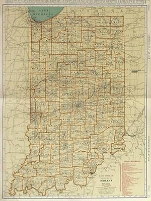
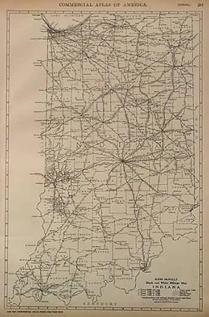
Rand McNally Standard Map of Indiana
Date d'édition : 1930
Vendeur : Art Source International Inc., Boulder, CO, Etats-Unis
Evaluation du vendeur :
Edition originale
Rand McNally & Company, still a major name in map publishing to this day, began as a small print shop opened in Chicago in 1856 by William H. Rand. The shop originally printed guidebooks and directories. In 1858, Rand hired Andrew McNally who was later to become a partner. Within the next few years, the shop got into the railroad business by starting to print railway tickets and schedules, a key step in the development of the company. The ticket printing led to the publishing of railway guides, and by 1872 Rand McNally and Company had the capacity to publish maps. This map of Indiana came from Rand McNally's Commercial Atlas, sixty-first Edition dated 1930. A highly successful run of atlases that lasted over a decade. These maps were primarily used by business, because of their accurate listing of railroads in operation as well as tables of statistical information. This map is unique in several ways, their large format makes an impressive display, and offers additional room where many small towns and extra details are included. Additionally a list of every railroad operating in the state in 1930 is included. All railroad routes are shown on the map. This map includes all cities and towns, lakes, rivers, and bodies of water. All topographical features are also included as well as political features such as counties and Native American Indian reservations. This map measures 26 inches by 19 inches.
-
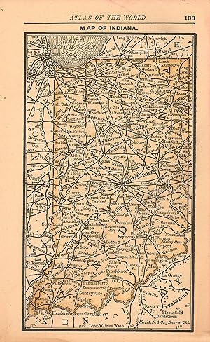
MAP: "Indiana".from the New Indexed Atlas of the World
Edité par Rand McNally & Co, Chicago, IL, 1887
Vendeur : Dorley House Books, Inc., Hagerstown, MD, Etats-Unis
Evaluation du vendeur :
Art / Affiche / Gravure
Unbound. Etat : Very Good. Handcolored Map (illustrateur). .very nice w/decorative border; 20.5" x 11.25" map, suitable for framing [2 scans=full image] Size: 20.5" x 11.25".
-

Rand McNally Junior Auto Road Map of Indiana
Date d'édition : 1932
Vendeur : Art Source International Inc., Boulder, CO, Etats-Unis
Evaluation du vendeur :
Rand McNally & Company, still a major name in map publishing to this day, began as a small print shop opened in Chicago in 1856 by William H. Rand. The shop originally printed guidebooks and directories. In 1858, Rand hired Andrew McNally who was later to become a partner. Within the next few years, the shop got into the railroad business by starting to print railway tickets and schedules, a key step in the development of the company. The ticket printing led to the publishing of railway guides, and by 1872 Rand McNally and Company had the capacity to publish maps. This map of Indiana came from Rand McNallys Commercial Atlas. A highly successful run of atlases that lasted over a decade. These maps were primarily used by business, because of their accurate listing of railroads in operation as well as tables of statistical information. This map is unique in several ways, their large format makes an impressive display, and offers additional room where many small towns and extra details are included. Additionally a list of every railroad operating in the state in 1932 is included. All railroad routes are shown on the map. This map includes all cities and towns, lakes, rivers, and bodies of water. All topographical features are also included as well as political features such as counties and Native American Indian reservations. This map measures 11 inches by 17 inches.
-
Rand McNally Standard Map of Indiana
Date d'édition : 1938
Vendeur : Art Source International Inc., Boulder, CO, Etats-Unis
Evaluation du vendeur :
Rand McNally & Company, still a major name in map publishing to this day, began as a small print shop opened in Chicago in 1856 by William H. Rand. The shop originally printed guidebooks and directories. In 1858, Rand hired Andrew McNally who was later to become a partner. Within the next few years, the shop got into the railroad business by starting to print railway tickets and schedules, a key step in the development of the company. The ticket printing led to the publishing of railway guides, and by 1872 Rand McNally and Company had the capacity to publish maps. This map of Indiana came from Rand McNallys Commercial Atlas. A highly successful run of atlases that lasted over a decade. These maps were primarily used by business, because of their accurate listing of railroads in operation as well as tables of statistical information. This map measures 19 inches by 26 inches.
-
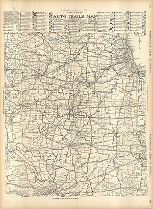
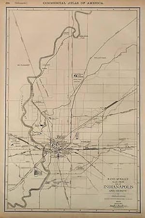
McNally's 1922 Auto Trails Map of Illinois, Western Indiana, S.E. Iowa, and N.E. Missouri
Date d'édition : 1922
Vendeur : Art Source International Inc., Boulder, CO, Etats-Unis
Evaluation du vendeur :
This map of Illinois, Indiana, Iowa, and Missouri was produced by Rand McNally and Co. as part of its Commercial Atlas of America. The detail shown on each map is exceptional because of the map size. These maps were intended to be used by business for shipping, etc. Roads, railroads, and rivers are clearly shown. There is more detail on these maps than any others during this time period.The map measures 19 by 25 inches.
-
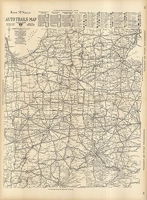
McNally's 1922 Auto Trails Map of Eastern Illinois, Southern Mich., Indiana, Western Ohio, and Northern Kentucky
Date d'édition : 1922
Vendeur : Art Source International Inc., Boulder, CO, Etats-Unis
Evaluation du vendeur :
This map of Illinois, Michigan, Indiana, Ohio, and Kentucky was produced by Rand McNally and Co. as part of its Commercial Atlas of America. The detail shown on each map is exceptional because of the map size. These maps were intended to be used by business for shipping, etc. Roads, railroads, and rivers are clearly shown. There is more detail on these maps than any others during this time period. This map measures 25 inches by 19 inches.