
Montant total (1 article articles) :
Destination de la commande :

kimberley de hema maps (7 résultats)
Passer aux résultats principaux de la recherche
Type d'article
- Tous les types d'articles
- Livres (7)
- Magazines & Périodiques
- Bandes dessinées
- Partitions de musique
- Art, Affiches et Gravures
- Photographies
- Cartes
-
Manuscrits &
Papiers anciens
Etat
Reliure
- Toutes
- Couverture rigide
- Couverture souple (3)
Particularités
- Edition originale (1)
- Signé
- Jaquette
- Avec images (2)
- Sans impression ŕ la demande
Pays
Evaluation du vendeur
-
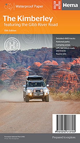
The Kimberley Map (Map)
Edité par Hema Maps Pty.Ltd, Brisbane, 2017
ISBN 10 : 1876413700ISBN 13 : 9781876413705
Vendeur : Grand Eagle Retail, Wilmington, DE, Etats-Unis
Evaluation du vendeur :

Livre
Map. Etat : new. Map. The Kimberley Map (15th edition) - a regional map of the Kimberley that features the iconic Gibb River Road. On the reverse are inset maps for Purnululu National Park, the Dampier Peninsula and the Parry Creek area. There is also extensive drive detail and trip coverage for the Gibb River Road. The Kimberley Map (15th edition) - a regional map of the Kimberley that features the iconic Gibb River Road. On the reverse are inset maps for Purnululu National Park, the Dampier Peninsula and the Parry Creek area. There is also extensive drive detail and trip coverage for the Gibb River Road. Shipping may be from multiple locations in the US or from the UK, depending on stock availability.
-
Etat : Good. Most items will be dispatched the same or the next working day.
-

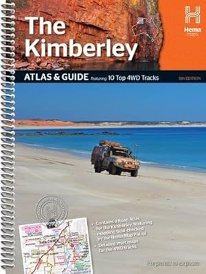
The Kimberley Atlas and Guide
Edité par Hema Maps Pty.Ltd, Brisbane, 2006
ISBN 10 : 1865003700ISBN 13 : 9781865003702
Vendeur : Great Southern Books, King River, WA, Australie
Evaluation du vendeur :

Livre Edition originale
Softcover (Spiral Bound). Etat : Very Good. First Edition. Size: 4to Quarto. 128 pages. Text body is clean, and free from previous owner annotation, underlining and highlighting. Ring binding is in excellent condition. No foxing detected in this copy. All edges clean, neat and free of foxing. This book is available and will be shipped within two business days. All items are tracked and details are available on request. A self-drive touring guide and reference for travelling the Kimberley region of north-western Australia. Quantity Available: 1. Shipped Weight: Under 1 kilogram. Category: Travel & Places; Australia; Reference. ISBN: 1865003700. ISBN/EAN: 9781865003702. Pictures of this item not already displayed here available upon request. Inventory No: 5438.
-
The Kimberley Map (Map)
Edité par Hema Maps Pty.Ltd, Brisbane, 2017
ISBN 10 : 1876413700ISBN 13 : 9781876413705
Livre
Map. Etat : new. Map. The Kimberley Map (15th edition) - a regional map of the Kimberley that features the iconic Gibb River Road. On the reverse are inset maps for Purnululu National Park, the Dampier Peninsula and the Parry Creek area. There is also extensive drive detail and trip coverage for the Gibb River Road. The Kimberley Map (15th edition) - a regional map of the Kimberley that features the iconic Gibb River Road. On the reverse are inset maps for Purnululu National Park, the Dampier Peninsula and the Parry Creek area. There is also extensive drive detail and trip coverage for the Gibb River Road. Shipping may be from our Sydney, NSW warehouse or from our UK or US warehouse, depending on stock availability.
-
The Kimberley Map (Map)
Edité par Hema Maps Pty.Ltd, Brisbane, 2017
ISBN 10 : 1876413700ISBN 13 : 9781876413705
Livre
Map. Etat : new. Map. The Kimberley Map (15th edition) - a regional map of the Kimberley that features the iconic Gibb River Road. On the reverse are inset maps for Purnululu National Park, the Dampier Peninsula and the Parry Creek area. There is also extensive drive detail and trip coverage for the Gibb River Road. The Kimberley Map (15th edition) - a regional map of the Kimberley that features the iconic Gibb River Road. On the reverse are inset maps for Purnululu National Park, the Dampier Peninsula and the Parry Creek area. There is also extensive drive detail and trip coverage for the Gibb River Road. Shipping may be from our UK warehouse or from our Australian or US warehouses, depending on stock availability.
-
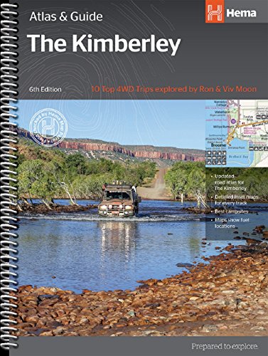
Kimberley Atlas & Guide (Map)
Edité par Hema Maps Pty.Ltd, QLD, 2018
ISBN 10 : 1876413646ISBN 13 : 9781876413644
Livre
Map. Etat : new. Map. Kimberley Atlas & Guide (6th Edition) - The definitive guidebook for exploring Western Australia's Kimberley region, featuring the Top 10 4WD Trips written by Ron and Viv Moon, in combination with topographic atlas mapping for the region. Kimberley Atlas & Guide (6th Edition) - The definitive guidebook for exploring Western Australia's Kimberley region, featuring the Top 10 4WD Trips written by Ron and Viv Moon, in combination with topographic atlas mapping for the region. Shipping may be from our UK warehouse or from our Australian or US warehouses, depending on stock availability.
-
Kimberley Atlas & Guide (Map)
Edité par Hema Maps Pty.Ltd, QLD, 2018
ISBN 10 : 1876413646ISBN 13 : 9781876413644
Livre
Map. Etat : new. Map. Kimberley Atlas & Guide (6th Edition) - The definitive guidebook for exploring Western Australia's Kimberley region, featuring the Top 10 4WD Trips written by Ron and Viv Moon, in combination with topographic atlas mapping for the region. Kimberley Atlas & Guide (6th Edition) - The definitive guidebook for exploring Western Australia's Kimberley region, featuring the Top 10 4WD Trips written by Ron and Viv Moon, in combination with topographic atlas mapping for the region. Shipping may be from our Sydney, NSW warehouse or from our UK or US warehouse, depending on stock availability.