
Montant total (1 article articles) :
Destination de la commande :

map united states territory oregon de washington hood m h stansbury (1 résultats)
Passer aux résultats principaux de la recherche
Type d'article
- Tous les types d'articles
- Livres
- Magazines & Périodiques
- Bandes dessinées
- Partitions de musique
- Art, Affiches et Gravures
- Photographies
- Cartes (1)
-
Manuscrits &
Papiers anciens
Etat
- Tous
- Neuf
- Ancien ou d'occasion
Reliure
- Toutes
- Couverture rigide
- Couverture souple
Particularités
- Edition originale
- Signé
- Jaquette
- Avec images
- Sans impression ŕ la demande
Pays
Evaluation du vendeur
-
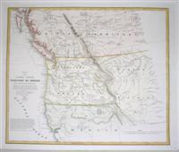
Map of the United States Territory of Oregon West of the Rocky Mountains.
Edité par Washington, U.S.A., 1838
Vendeur : Alexandre Antique Prints, Maps & Books, Toronto, ON, Canada
Membre d'association : ABAC ILAB
Evaluation du vendeur :

Carte
Etat : Excellent. Map of Oregon Territory before being officially incorporated as a US Territory on August 14, 1848.Washington Hood (February 2, 1808 ? July 17, 1840) was an American (born in Philadelphia) army officer in the Corps of Topographical Engineers. He drafted maps of the American West while exploring the areas (the Ohio Michigan border; northeastern Oklahoma, Indian tribes west of Arkansas and Missouri.etc.)., Size : 443x525 (mm), 17.375x20.625 (Inches), Hand Colored in Outline, 0.