
Montant total (1 article articles) :
Destination de la commande :

mechlin malines capital ten provinces de basire (4 résultats)
Passer aux résultats principaux de la recherche
Type d'article
- Tous les types d'articles
- Livres (1)
- Magazines & Périodiques
- Bandes dessinées
- Partitions de musique
- Art, Affiches et Gravures
- Photographies
- Cartes (3)
-
Manuscrits &
Papiers anciens
Etat
- Tous
- Neuf
- Ancien ou d'occasion
Reliure
- Toutes
- Couverture rigide
- Couverture souple
Particularités
- Edition originale
- Signé
- Jaquette
- Avec images
- Sans impression ŕ la demande
Pays
Evaluation du vendeur
-
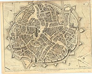
Mechlin, or Malines the Capital of one of the Ten Provinces of the Netherlands in Brabant an Archbishoprick, situated upon ye Dyle. For Mr. Tindal's Continuation of Mr. Rapin's History of England.
Edité par London c., 1745
Vendeur : Robert Frew Ltd. ABA ILAB, London, Royaume-Uni
Membre d'association : ABA ILAB PBFA
Evaluation du vendeur :

Carte
Original folding uncoloured copper engraved plan (36.5 x 47cm). Slightly shaved at upper margin, faint offsetting, generally very good. Attractive and detailed plan of this Flemish town, showing every house and the extensive fortifications surrounding the town. North to the left.
-
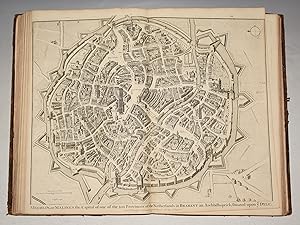
Original Copper Engraved View of Mechlin, or Malines the Capital of one of the Ten Provinces of the Netherlands in Brabant an Archbishoprick, situated upon ye Dyle.
Edité par London John & Paul Knapton 1752, 1752
Vendeur : PROCTOR / THE ANTIQUE MAP & BOOKSHOP, DORCHESTER, Royaume-Uni
Membre d'association : PBFA
Evaluation du vendeur :
Unmounted. Original engraved double page plan. Size 19 x 16 inches. (49 x 40 cm) In very good condition. Centre Fold as issued. Two tiny dot holes on title lower margin. Left & right margins slightly trimmed, not effecting main engraving. Uncoloured, Blank on verso. The decorative cartouche holds the key to the numbers on the map. Original engraved folding page map Bird's eye view style map. Antique black and white View of the city Mechlin, or Malines, Showing battle lines and positions, contours and geographical features such as buildings, fortifications, fields and rivers. from Thomas Rapin's 'History of England'.
-
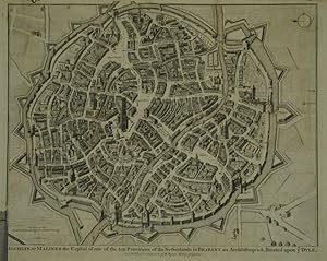
Mechlin or Malines the Capital of one of the ten Provinces of the Netherlands in Brabant, an Archbishoprick, situated upon ye Dyle.
Edité par London-7, 1743
Vendeur : Robert Frew Ltd. ABA ILAB, London, Royaume-Uni
Membre d'association : ABA ILAB PBFA
Evaluation du vendeur :
Carte
36.5 x 46.8 cm. Uncoloured. Double page town plan. One horizontal fold and two vertical. Some light offsetting. Lower left margin narrow though border remains intact, small tear without loss to same corner encroaching into image.
-
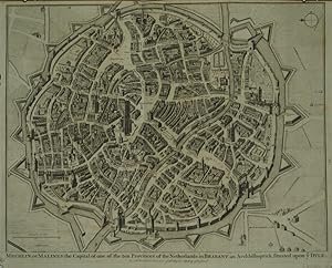
Mechlin or Malines the Capital of one of the ten Provinces of the Netherlands in Brabant, an Archbishoprick, situated upon ye Dyle.
Edité par London-47, 1732
Vendeur : Robert Frew Ltd. ABA ILAB, London, Royaume-Uni
Membre d'association : ABA ILAB PBFA
Evaluation du vendeur :
Carte
36.5 x 47 cm. Uncoloured. Double page town plan. Small tear without loss left margin, otherwise in good conditon.