
Montant total (1 article articles) :
Destination de la commande :

menin strong town earldom flanders de basire (3 résultats)
Passer aux résultats principaux de la recherche
Type d'article
- Tous les types d'articles
- Livres (2)
- Magazines & Périodiques
- Bandes dessinées
- Partitions de musique
- Art, Affiches et Gravures
- Photographies
- Cartes (1)
-
Manuscrits &
Papiers anciens
Etat
- Tous
- Neuf
- Ancien ou d'occasion
Reliure
- Toutes
- Couverture rigide
- Couverture souple
Particularités
- Edition originale
- Signé
- Jaquette
- Avec images (2)
- Sans impression ŕ la demande
Pays
Evaluation du vendeur
-
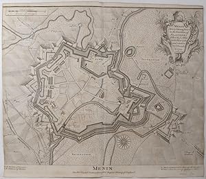
Menin. A very Strong Town in the Earldom of Flanders. Taken by ye Allies in the Year 1706 and retaken by ye French in 1744.
Edité par London-47, 1743
Vendeur : Robert Frew Ltd. ABA ILAB, London, Royaume-Uni
Membre d'association : ABA ILAB PBFA
Evaluation du vendeur :

Carte
41 x 48 cm. Uncoloured. Double page plan. Left and right margins cropped to within the border.
-
Original Copper Engraved Plan of Menin. A very Strong Town in the Earldom of Flanders. Taken by ye Allies in the Year 1706 and retaken by ye French in 1744.
Edité par London John & Paul Knapton 1752, 1752
Vendeur : PROCTOR / THE ANTIQUE MAP & BOOKSHOP, DORCHESTER, Royaume-Uni
Membre d'association : PBFA
Evaluation du vendeur :
Unmounted. Original engraved double page plan. Size 19 x 16 inches. (49 x 40 cm) In very good condition. Centre Fold as issued. Two tiny dot holes on title lower margin. Some very light tanning. Uncoloured, Blank on verso. Original engraved folding page map Bird's eye view style map. Antique black and white View of the City of Menin. MILITARY MAP. Showing battle lines and positions, contours and geographical features such as buildings, fortifications, fields and rivers. from Thomas Rapin's 'History of England'.
-

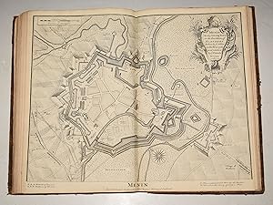
Menin A very Strong Town in the Earldom, of Flanders Taken by ye Allies in the year 1706 and retaken by ye French in 1744 - Original Antique Hand-Coloured Copper-engraved Plan
Date d'édition : 1750
Vendeur : K Books Ltd ABA ILAB, York, YORKS, Royaume-Uni
Membre d'association : ABA ILAB PBFA
Evaluation du vendeur :
Livre
No Binding. Etat : Very Good. Basire (illustrateur). Hand-coloured Copper engraved plan, mounted (matted) and ready to frame in the UK, but for overseas customers it would probably be unmounted as it would be too large to post. Colouring not contemporary, but delicately and expertly done. No date, but printed c 1750. Plan of the city of Menin, showing the positions of the batteries of cannon and mortars. Printed for Mr Tindal's continuation of Mr Rapin's History of England.
