Montant total (1 article articles) :
Destination de la commande :

north africa barbary tripoli (38 résultats)
Passer aux résultats principaux de la recherche
Type d'article
- Tous les types d'articles
- Livres (9)
- Magazines & Périodiques
- Bandes dessinées
- Partitions de musique
- Art, Affiches et Gravures
- Photographies
- Cartes (29)
-
Manuscrits &
Papiers anciens
Etat
Reliure
- Toutes
- Couverture rigide (1)
- Couverture souple
Particularités
- Edition originale
- Signé
- Jaquette
- Avec images (36)
- Sans impression ŕ la demande (37)
Pays
Evaluation du vendeur
-
GENUINE ANTIQUE MAP TAKEN FROM. MAPS. OF . THE SOCIETY FOR THE DIFFUSION . OF . USEFUL KNOWLEDGELONDON: CHAPMAN AND HALL. 1844Condition/Description: outline hand colouring, 39cm x 32cm with margins beyond, blank reverse side, in good, clean condition - please refer to images and examine carefully. Perfectly suitable for framing . GENUINE ANTIQUE MAP. NOT A COPY. NOT A REPRODUCTION. MONEY BACK GUARANTEE IF NOT COMPLETELY SATISFIED.DISCOUNTS AVAILABLE ON MUTIPLE PURCHASES - PLEASE ASK.
-
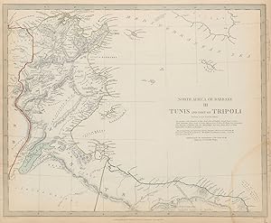
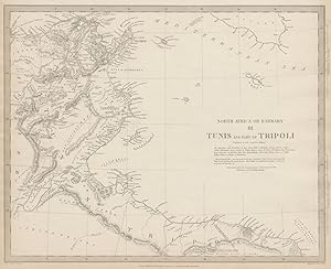
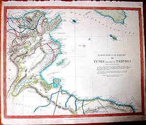
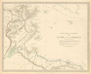
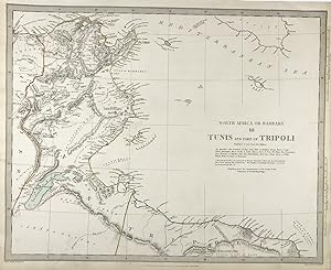
Etat : Fair. NORTH AFRICA or BARBARY. Tunis & part of Tripoli. Tunisia Libya. SDUK 1844 map. Antique steel engraved map with original outline hand colouring (coloring); Cartography by Shaw, Smyth, Temple etc; engraved by J & C Walker (This map was originally published by Baldwin & Cradock in 1836; this date is printed on the map. This edition of the map was printed and published by Chapman & Hall in 1844.). 33.0 x 41.0cm, 13 x 16 inches. Condition: Fair: Tide mark in lower right corner. There is nothing printed on the reverse side, which is plain.
-
Etat : Good. NORTH AFRICA OR BARBARY III. Tunis & Part of Tripoli Tunisia Libya SDUK 1846 map. Antique steel engraved map with original outline hand colouring; Cartography by Shaw, Smyth, Temple, Beechey etc; engraved by J & C Walker (1846). 34.5 x 41.0cm, 13.5 x 16 inches. Condition: Good. The image shown may have been taken from a different example of this map than that which is offered for sale. The map you will receive is in good condition but there may be minor variations in the condition from that shown in the image which may include some light spotting. This map was coloured by hand at the time of publication, thus the colouration may vary slightly between different examples of the map; the colouring applied to the map you receive may differ slightly from that shown in the image. There is nothing printed on the reverse side, which is plain.
-
Etat : Good. NORTH AFRICA OR BARBARY III. Tunis & Part of Tripoli Tunisia Libya SDUK 1857 map. Antique steel engraved map with original hand colouring; Cartography by Shaw, Smyth, Temple, Beechey etc; engraved by J & C Walker (1857). 34.5 x 41.0cm, 13.5 x 16 inches. Condition: Good. There is nothing printed on the reverse side, which is plain.
-
![Image du vendeur pour Tripoli in Barbary: Including an Insight into North Africa and the Sahara and a Brief Comment on the French Scheme of Empire in Africa Volume 2 [LeatherBound] mis en vente par True World of Books](https://pictures.abebooks.com/inventory/md/md31533061208.jpg)
Tripoli in Barbary: Including an Insight into North Africa and the Sahara and a Brief Comment on the French Scheme of Empire in Africa Volume 2 [LeatherBound]
Date d'édition : 2023
Livre impression ŕ la demande
LeatherBound. Etat : New. Leather Binding on Spine and Corners with Golden leaf printing on spine. Bound in genuine leather with Satin ribbon page markers and Spine with raised gilt bands. A perfect gift for your loved ones. Reprinted from 1911 edition. NO changes have been made to the original text. This is NOT a retyped or an ocr'd reprint. Illustrations, Index, if any, are included in black and white. Each page is checked manually before printing. As this print on demand book is reprinted from a very old book, there could be some missing or flawed pages, but we always try to make the book as complete as possible. Fold-outs, if any, are not part of the book. If the original book was published in multiple volumes then this reprint is of only one volume, not the whole set and contains approximately 28 pages. IF YOU WISH TO ORDER PARTICULAR VOLUME OR ALL THE VOLUMES YOU CAN CONTACT US. Resized as per current standards. Sewing binding for longer life, where the book block is actually sewn (smythe sewn/section sewn) with thread before binding which results in a more durable type of binding. Language: English.
-
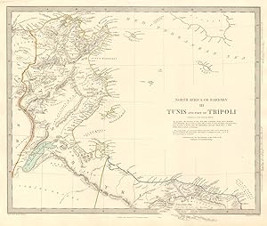
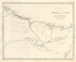
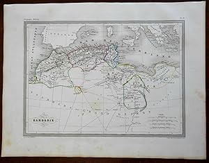
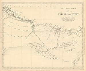
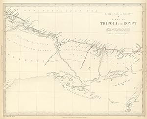
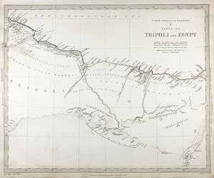
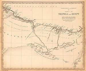
Etat : Good. NORTH AFRICA BARBARY. Parts of Tripoli (Libya) & Egypt. Tribes. SDUK 1848 map. Antique steel engraved map; Cartography by Smyth, Horneman, Pacho, Brown; engraved by J & C Walker (This map was originally published by Baldwin & Cradock in 1837; this date is printed on the map. This edition of the map was printed and published by Charles Knight in 1848.). 33.0 x 40.5cm, 13 x 16 inches. Condition: Poor: . There is nothing printed on the reverse side, which is plain.
-
Etat : Good. NORTH AFRICA OF BABRBARY V Parts of Tripoli & Egypt. Libya Tribes. SDUK 1846 map. Antique steel engraved map with original outline hand colouring; Cartography by Smyth 1817, Horneman 1798, Pacho 1825, Browne 1792; engraved by J & C Walker (1846). 34.5 x 41.5cm, 13.5 x 16.25 inches. Condition: Good. The image shown may have been taken from a different example of this map than that which is offered for sale. The map you will receive is in good condition but there may be minor variations in the condition from that shown in the image which may include some light spotting. This map was coloured by hand at the time of publication, thus the colouration may vary slightly between different examples of the map; the colouring applied to the map you receive may differ slightly from that shown in the image. There is nothing printed on the reverse side, which is plain.
-
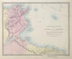
Etat : Good. TUNISIA & LIBYA. North Africa or Barbary III Tripoli Gulf of Gabes SDUK 1844 map. Antique steel engraved map; Cartography by Shaw, Smyth, Temple etc; engraved by J & C Walker (This map was originally published by Baldwin & Cradock in 1836; this date is printed on the map. This edition of the map was printed and published by Chapman & Hall in 1844.). 33.0 x 41.0cm, 13 x 16 inches. Condition: Good. There is nothing printed on the reverse side, which is plain.
-
Etat : Good. TUNISIA LIBYA. North Africa or Barbary. Tunis Tripoli. SDUK 1844 old map. Antique steel engraved map with original outline hand colouring (coloring); Cartography by Shaw, Smyth, Temple etc; engraved by J & C Walker (This map was originally published by Baldwin & Cradock in 1836; this date is printed on the map. This edition of the map was printed and published by Chapman & Hall in 1844.). 33.0 x 41.0cm, 13 x 16 inches. Condition: Good. The image shown may have been taken from a different example of this map than that which is offered for sale. The map you will receive is in good condition but there may be minor variations in the condition from that shown in the image. This map was coloured by hand at the time of publication, thus the colouration may vary slightly between different examples of the map; the colouring applied to the map you receive may differ slightly from that shown in the image. There is nothing printed on the reverse side, which is plain.
-
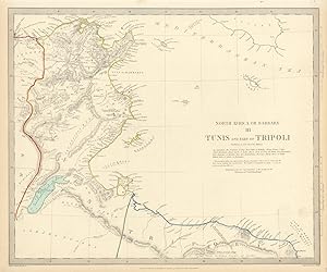
Etat : Good. TUNISIA LIBYA. North Africa or Barbary. Tunis Tripoli. SDUK 1844 old map. Antique steel engraved map with original outline hand colouring (coloring); Cartography by Shaw, Smyth, Temple etc; engraved by J & C Walker (This map was originally published by Baldwin & Cradock in 1836; this date is printed on the map. This edition of the map was printed and published by Charles Knight in 1844.). 33.0 x 41.0cm, 13 x 16 inches. Condition: Good. There is nothing printed on the reverse side, which is plain.
-
Etat : Good. NORTH AFRICA BARBARY. Parts of Tripoli (Libya) & Egypt. Tribes. SDUK 1844 map. Antique steel engraved map with original outline hand colouring (coloring); Cartography by Smyth, Horneman, Pacho, Brown; engraved by J & C Walker (This map was originally published by Baldwin & Cradock in 1837; this date is printed on the map. This edition of the map was printed and published by Chapman & Hall in 1844.). 33.0 x 40.5cm, 13 x 16 inches. Condition: Good. The image shown may have been taken from a different example of this map than that which is offered for sale. The map you will receive is in good condition but there may be minor variations in the condition from that shown in the image. This map was coloured by hand at the time of publication, thus the colouration may vary slightly between different examples of the map; the colouring applied to the map you receive may differ slightly from that shown in the image. There is nothing printed on the reverse side, which is plain.
-
Etat : Good. NORTH AFRICA BARBARY. Parts of Tripoli (Libya) & Egypt. Tribes. SDUK 1844 map. Antique steel engraved map with original outline hand colouring (coloring); Cartography by Smyth, Horneman, Pacho, Brown; engraved by J & C Walker (This map was originally published by Baldwin & Cradock in 1837; this date is printed on the map. This edition of the map was printed and published by Charles Knight in 1844.). 33.0 x 40.5cm, 13 x 16 inches. Condition: Good. There is nothing printed on the reverse side, which is plain.
-
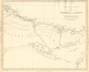
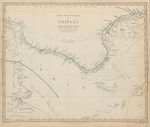
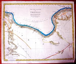
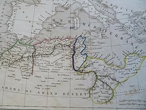
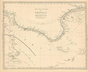
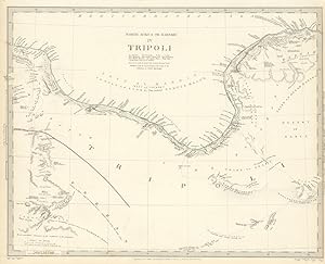
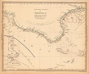
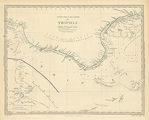
Etat : Fair. NORTH AFRICA or BARBARY. Tripoli. Libya Gulf of Sidra Sirte Fezzan SDUK 1844 map. Antique steel engraved map with original outline hand colouring (coloring); Cartography by Smyth, Lyon, Denham &c; engraved by J & C Walker (This map was originally published by Baldwin & Cradock in 1837; this date is printed on the map. This edition of the map was printed and published by Chapman & Hall in 1844.). 33.0 x 40.5cm, 13 x 16 inches. Condition: Fair: Tide mark in lower right corner. Restored paper loss in top left hand corner margin. There is nothing printed on the reverse side, which is plain.
-
North Africa or Barbary V - Parts of Tripoli and Egypt" - Egypt Libya Tripoli Libyen Africa engraving map Karte SDUK Afrique
Edité par London, 1837
Vendeur : Antiquariat Steffen Völkel GmbH, Seubersdorf, Allemagne
Membre d'association : ILAB VDA
Evaluation du vendeur :

Carte
Großformatige original Stahlstich Karte von 1837 aus dem Atlas: "Maps of the Society for the Diffusion of useful knowledge" - Blattmasse: ca. 41 x 34 cm - gut erhalten. | large sized original steel engraved map from 1837 out of the atlas "Maps of the Society for the diffusion of useful knowledge" - size of sheet: circa 16.1 x 13.4 inches - good condition. Sprache: Englisch Gewicht in Gramm: 1500.
-
North Africa or Barbary III Tunis and part of Tripoli" - Tunis Tripoli Tunesia Libanon Africa engraving map Karte SDUK Afrique
Edité par London, 1836
Vendeur : Antiquariat Steffen Völkel GmbH, Seubersdorf, Allemagne
Membre d'association : ILAB VDA
Evaluation du vendeur :
Carte
Großformatige original Stahlstich Karte von 1836 aus dem Atlas: "Maps of the Society for the Diffusion of useful knowledge" - Blattmasse: ca. 41 x 34 cm - gut erhalten. | large sized original steel engraved map from 1836 out of the atlas "Maps of the Society for the diffusion of useful knowledge" - size of sheet: circa 16.1 x 13.4 inches - good condition. Sprache: Englisch Gewicht in Gramm: 1500.
-

North Africa or Barbary IV Tripoli" - Tripoli Libya Libyen North Africa engraving map Karte SDUK Afrique
Edité par London, 1837
Vendeur : Antiquariat Steffen Völkel GmbH, Seubersdorf, Allemagne
Membre d'association : ILAB VDA
Evaluation du vendeur :
Carte
Großformatige original Stahlstich Karte von 1837 aus dem Atlas: "Maps of the Society for the Diffusion of useful knowledge" - Blattmasse: ca. 41 x 34 cm - gut erhalten. | large sized original steel engraved map from 1837 out of the atlas "Maps of the Society for the diffusion of useful knowledge" - size of sheet: circa 16.1 x 13.4 inches - good condition. Sprache: Englisch Gewicht in Gramm: 1500.
-
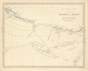
Etat : Good. NORTH AFRICA OF BABRBARY V Parts of Tripoli & Egypt. Libya Tribes. SDUK 1851 map. Antique steel engraved map with original outline hand colouring; Cartography by Smyth 1817, Horneman 1798, Pacho 1825, Browne 1792; engraved by J & C Walker (1851). 34.5 x 41.5cm, 13.5 x 16.25 inches. Condition: Good. The image shown may have been taken from a different example of this map than that which is offered for sale. The map you will receive is in good condition but there may be minor variations in the condition from that shown in the image. This map was coloured by hand at the time of publication, thus the colouration may vary slightly between different examples of the map; the colouring applied to the map you receive may differ slightly from that shown in the image. There is nothing printed on the reverse side, which is plain.
-
Antique Map: North Africa or Barbary IV Tripoli
Edité par Society for the Diffusion of Useful Knowledge, London, 1837
Livre
No Binding. Etat : Very Good. Hand-coloured in outline. 15.5 x 12 inches or 39 by 30 cm. Minor wear. Very Good.
-
Antique Map: North Africa or Barbary III Tunis and Part of Tripoli
Edité par Society for the Diffusion of Useful Knowledge, London, 1837
Livre
No Binding. Etat : Very Good. Hand-coloured in outline. 13.5 x 16 in or 34.29 x 40.64 cm. M inor wear. Very Good.
-
North Africa or Barbary V Parts of Tripoli and Egypt - Published under the Superintendence of the Society for the Diffusion of Useful Knowledge.
Edité par Baldwin & Cradock, London, 1837
Vendeur : Antiquariat Reinhold Berg eK Inh. R.Berg, Regensburg, Allemagne
Membre d'association : ILAB VDA
Evaluation du vendeur :

Carte
Other. Steel engraving, hand colored in outline when published. This is a very detailed map from North Africa with parts of Tripoli and Egypt. In excellent condition. 320 by 390mm (12˝ by 15Ľ inches). 320 by 390mm (12˝ by 15Ľ inches).
-
Etat : Good. LIBYA.GULF OF SIDRA SIRTE. North Africa or Barbary.Tripoli Fezzan.SDUK 1844 map. Antique steel engraved map with original outline hand colouring (coloring); Cartography by Smyth, Lyon, Denham &c; engraved by J & C Walker (This map was originally published by Baldwin & Cradock in 1837; this date is printed on the map. This edition of the map was printed and published by Chapman & Hall in 1844.). 33.0 x 40.5cm, 13 x 16 inches. Condition: Good. The image shown may have been taken from a different example of this map than that which is offered for sale. The map you will receive is in good condition but there may be minor variations in the condition from that shown in the image. This map was coloured by hand at the time of publication, thus the colouration may vary slightly between different examples of the map; the colouring applied to the map you receive may differ slightly from that shown in the image. There is nothing printed on the reverse side, which is plain.
-
Etat : Good. LIBYA.GULF OF SIDRA SIRTE. North Africa or Barbary.Tripoli Fezzan.SDUK 1844 map. Antique steel engraved map with original outline hand colouring (coloring); Cartography by Smyth, Lyon, Denham &c; engraved by J & C Walker (This map was originally published by Baldwin & Cradock in 1837; this date is printed on the map. This edition of the map was printed and published by Charles Knight in 1844.). 33.0 x 40.5cm, 13 x 16 inches. Condition: Good. There is nothing printed on the reverse side, which is plain.
-
North Africa Barbary Tunis Tripoli coast Jerbah c.1836 SDUK detailed Walker map
Date d'édition : 1836
Vendeur : RareMapsandBooks, Dover, NH, Etats-Unis
Membre d'association : ESA IOBA
Evaluation du vendeur :
Carte
Etat : good. North Africa or Barbary III. Tunis and Part of Tripoli. (North Africa / Barbary / Tunis / Tripoli). Issued 1836, London by Society for Diffusion of Useful Knowledge (SDUK). Engraved by J & C Walker. Detailed early to mid- 19th century antique map, engraved with original outline hand color. Overall mostly clean, pleasing age patina, nice looking example. Sheet measures c. 13 1/2" x 16 1/4". Printed area measures c. 12 1/2" x 15 1/2". Tooley's Dictionary of Mapmakers, vol.4. [R17089]. Guaranteed authentic - old. We do not sell modern reprints.
-
North Africa or Barbary IV Tripoli - Published under the Superintendence of the Society for the Diffusion of Useful Knowledge.
Edité par Baldwin & Cradock, London, 1837
Vendeur : Antiquariat Reinhold Berg eK Inh. R.Berg, Regensburg, Allemagne
Membre d'association : ILAB VDA
Evaluation du vendeur :
Carte
Other. Steel engraving, hand colored in outline when published. This antique map shows Tripoli in North Africa. Along the coast are many place names engraved. In excellent condition. 318 by 390mm (12˝ by 15Ľ inches). 318 by 390mm (12˝ by 15Ľ inches).
-

Tunis and Tripoli - north Africa or Barbary - an Antique Map
Vendeur : K Books Ltd ABA ILAB, York, YORKS, Royaume-Uni
Membre d'association : ABA ILAB PBFA
Evaluation du vendeur :
Livre
No Binding. Etat : Very Good. Engraved By Walker (illustrateur). A fine antique map in very good condition - printed in circa 1844. Mounted (matted) and ready to frame. Engraved size approx 16 x 13 Ins, 41 x 33 Cms. Mounted size approx 19 x 16 in, 49 x 41cm. Coloured in outline, hand colouring contemporary. A fine engraved map of Tunis and Tripoli - north Africa or Barbary.
-
Tunis and Tripoli - north Africa or Barbary - an Antique Map
Vendeur : K Books Ltd ABA ILAB, York, YORKS, Royaume-Uni
Membre d'association : ABA ILAB PBFA
Evaluation du vendeur :
Livre
No Binding. Etat : Very Good. Engraved By Walker (illustrateur). A fine antique map in very good condition - printed in circa 1844. Mounted (matted) and ready to frame. Engraved size approx 16 x 13 Ins, 41 x 33 Cms. Mounted size approx 19 x 16 in, 49 x 41cm. Coloured in outline, hand colouring contemporary. A fine engraved map of Tripoli - North Africa or Barbary.
-
North Africa "Barbary Coast" Morocco Algeria Tunis Tripoli 1850 Bellier map
Date d'édition : 1850
Vendeur : RareMapsandBooks, Dover, NH, Etats-Unis
Membre d'association : ESA IOBA
Evaluation du vendeur :
Carte
Etat : good. Barbarie.(Africa, North Africa, Barbary Coast, Morocco, Algeria, Tunis, Tripoli, Fez). Issued c. 1850, Paris by P. Bellier. Engraved by A. Vuillemin. Mid 19th century engraved map with original outline hand color. Nice looking example, pleasing age patina, any minor age flaws easy to overlook or forgive. Sheet Measures c. 12" H x 15" W. Engraved Area Measures c. 8 1/2" H x 11 1/2" W. Cartographic Reference (s):Tooley'sĂ Dictionary of Mapmakers, vol. 1.[R24255].
-
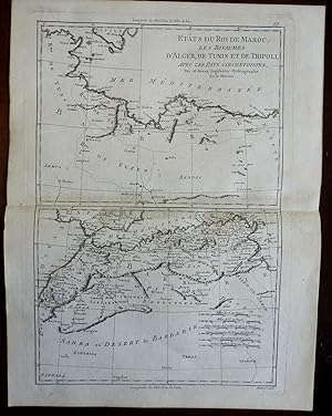
North Africa Barbary Coast Morocco Algeria Tunis Tripoli 1780 Bonne engraved map
Date d'édition : 1780
Vendeur : RareMapsandBooks, Dover, NH, Etats-Unis
Membre d'association : ESA IOBA
Evaluation du vendeur :
Carte
Etat : good. Etats du Roi de Maroc, les Royaumes D'Alger, De Tunis, Et De Tripoli, Avec Les Pays Circonuoisins.(Africa, North Africa, Morocco, Algeria, Tunis, Tripoli, Sahara Desert, Atlas Mountains, Fez, Algiers). Issued c.1780, Paris by M. Bonne. Engraved by Andre. Late 18th century engraved map with a pleasing impression. Nice looking example, pleasing age patina, any minor age flaws easy to overlook or forgive. Original center fold as issued. Sheet Measures c. 10" W x 15" H. Engraved Area Measures c. 8 3/8" W x 12 1/2" H. Cartographic Reference (s):Tooley'sĂ Dictionary of Mapmakers, vol. 1.[R24898].
-
Barbary Coast North Africa Morocco Algeria Tunis Tripoli 1850 Fremin map
Date d'édition : 1850
Vendeur : RareMapsandBooks, Dover, NH, Etats-Unis
Membre d'association : ESA IOBA
Evaluation du vendeur :
Carte
Etat : good. Cotes de Barbarie.(Old Maps, 19th Century Maps, Africa, North Africa, Barbary States, Morocco, Algeria, Tunis, Tripoli). Issued c. 1850, Paris by Fremin. Mid 19th century engraved historical map with original outline hand color. Old rubber stamp on reverse which bleeds through but is easy to overlook. Well preserved, nice looking example with pleasing age patina. Sheet Measures c. 9" H x 11 1/4" W. Engraved Area Measures c. 8" H x 10" W. Cartographic Reference (s):Tooley's Dictionary of Mapmakers, vol. 2.[R30701].
-
Etat : Good. NORTH AFRICA OF BABRBARY IV. TRIPOLI. Libya. Gulf of Sidra Sirte. SDUK 1851 map. Antique steel engraved map with original outline hand colouring; Cartography by Smyth 1817, Lyon 1819, Denham 1824, Horneman 1798, Della Cella 1817, Beechey 1822, Pacho 1825; engraved by J & C Walker (1851). 34.0 x 41.5cm, 13.5 x 16.25 inches. Condition: Good. However, please note: The image shown may have been taken from a different example of this map than that which is offered for sale. The map you will receive is in good condition but there may be minor variations in the condition from that shown in the image. This map was coloured by hand at the time of publication, thus the colouration may vary slightly between different examples of the map; the colouring applied to the map you receive may differ slightly from that shown in the image. There is nothing printed on the reverse side, which is plain.