
Montant total (1 article articles) :
Destination de la commande :

paskaert doost kust engelandt dover de keulen johannes van (1 résultats)
Passer aux résultats principaux de la recherche
Type d'article
- Tous les types d'articles
- Livres
- Magazines & Périodiques
- Bandes dessinées
- Partitions de musique
- Art, Affiches et Gravures
- Photographies
- Cartes (1)
-
Manuscrits &
Papiers anciens
Etat
- Tous
- Neuf
- Ancien ou d'occasion
Reliure
- Toutes
- Couverture rigide
- Couverture souple
Particularités
- Edition originale
- Signé
- Jaquette
- Avec images
- Sans impression ŕ la demande
Pays
Evaluation du vendeur
-
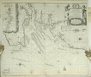
Paskaert Van d'Oost Kust van Engelandt van Dover tot Dunwich Als mede de Toems off de Rivier van Londen Met alle hunne Diepte en Drooghte op het Nieuws Over sien en van veel fouten verbetert.
Edité par Amsterdam:, 1681
Vendeur : Robert Frew Ltd. ABA ILAB, London, Royaume-Uni
Membre d'association : ABA ILAB PBFA
Evaluation du vendeur :

Carte
50.2 x 58.3 cm. Uncoloured. Double page chart of the coastline of south east England orientated with north to the right edge, showing the area from Folkestone through to Southwold. Inset chart of the Thames from the Estuary through to London. The chart with rhumb lines, compass roses, sea depths and an illustration of a ship to the sea. Lower margin narrow though intact, a small section of lower edge restored. Some very light offsetting, otherwise in good condition.