
Montant total (1 article articles) :
Destination de la commande :

plan different movements army allies de basire (2 résultats)
Passer aux résultats principaux de la recherche
Type d'article
- Tous les types d'articles
- Livres
- Magazines & Périodiques
- Bandes dessinées
- Partitions de musique
- Art, Affiches et Gravures
- Photographies
- Cartes (2)
-
Manuscrits &
Papiers anciens
Etat
- Tous
- Neuf
- Ancien ou d'occasion
Reliure
- Toutes
- Couverture rigide
- Couverture souple
Particularités
- Edition originale
- Signé
- Jaquette
- Avec images (1)
- Sans impression ŕ la demande
Pays
Evaluation du vendeur
-

Plan of different movements of ye Army of ye Allies under Prince Eugene of Savoy and of ye French Army, under Marshall Villars.
Edité par Knapton, John and Paul, London, 1744
Carte
18 1/4 x 14 3/4 inches. Richard William Seales and John Basire (illustrateur). 1744-47. Superb mid-eighteenth century engraving in a strong impression. Tindall translated Paul de Rapin's thirteen volume history into English. Additionally, he wrote a continuation updating the work to the rein of George II. He spent a small fortune on artists, cartographers, copper, engravers, illustrators, paper, printers and binders. He worked with the Knaptons who were noted period printers and publishers. These copiously engraved and grandly executed maps and views that are found in the "Continuation" speak for themselves. Good- trimmed to 1/4 inch top neatline. Several small tears repaired with archival materials.
-
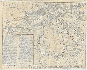
Plan of different Movements of ye Army of ye Allies under Prince Eugene of Savoy, and of ye French Army, under Marshall Villars; from ye beginning of ye Campaign, to ye 24th of July, 1712, when ye French attacked ye intrenched Camp at Denain commanded by the E. of Albemarle.
Edité par London-47, 1743
Vendeur : Robert Frew Ltd. ABA ILAB, London, Royaume-Uni
Membre d'association : ABA ILAB PBFA
Evaluation du vendeur :

Carte
41 x 48 cm. Uncoloured. Double page battle plan. Panel with "Explanation" to lower left corner. Left and right margins cropped at feet. Some light offsetting. Generally good.
