
Montant total (1 article articles) :
Destination de la commande :

plan settlement prairie chiens report de lee (1 résultats)
Passer aux résultats principaux de la recherche
Type d'article
- Tous les types d'articles
- Livres
- Magazines & Périodiques
- Bandes dessinées
- Partitions de musique
- Art, Affiches et Gravures
- Photographies
- Cartes (1)
-
Manuscrits &
Papiers anciens
Etat
- Tous
- Neuf
- Ancien ou d'occasion
Reliure
- Toutes
- Couverture rigide
- Couverture souple
Particularités
- Edition originale
- Signé
- Jaquette
- Avec images
- Sans impression ŕ la demande
Pays
Evaluation du vendeur
-
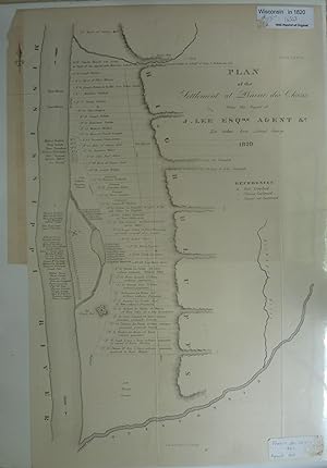
Plan Of The Settlement At Prairie Des Chiens From The Report Of J. Lee Esq., Agent.1820
Edité par Washington, 1865
Vendeur : Peninsula Books, Traverse City, MI, Etats-Unis
Evaluation du vendeur :

Carte
Map. Etat : Very Good. Etat de la jaquette : No Dust Jacket. An 1865 reprint of the 1820 original. This map produced in 1865 with original folds as issued. Shows the Mississippi, landowners along the Mississippi, the Ouisconsin River, the Kickapoo River, Fort Crawford, Old French Fort, etc. An interesting early Wisconsin map and suitable for framing. The labels on the photograph are not on the map, but are on shrinkwrap protecting the map. ; 14 3/4" x 20 7/8".