Montant total (1 article articles) :
Destination de la commande :

rand mcnally new england (63 résultats)
Passer aux résultats principaux de la recherche
Type d'article
- Tous les types d'articles
- Livres (60)
- Magazines & Périodiques
- Bandes dessinées
- Partitions de musique
- Art, Affiches et Gravures
- Photographies
- Cartes (3)
-
Manuscrits &
Papiers anciens
Etat
Reliure
Particularités
Pays
Evaluation du vendeur
-

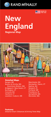
Rand McNally Easy To Fold: New England
Edité par Rand McNally (edition Laminated Map), 2013
ISBN 10 : 0528998382ISBN 13 : 9780528998386
Livre
Map. Etat : Very Good. Laminated Map. Ship within 24hrs. Satisfaction 100% guaranteed. APO/FPO addresses supported.
Plus de choix d'achat de la part d'autres vendeurs sur AbeBooks
Offres neuf ŕ partir de EUR 23,73
Offres d'occasion ŕ partir de EUR 5,44
Trouvez également Couverture souple
-
Rand McNally Folded Map: New England (Sheet Map, Folded)
Edité par Rand McNally 10/11/2021, 2021
ISBN 10 : 0528025775ISBN 13 : 9780528025778
Vendeur : BargainBookStores, Grand Rapids, MI, Etats-Unis
Evaluation du vendeur :

Livre
Sheet Map, Folded. Etat : New. Rand McNally Folded Map: New England 0.13. Book.
Plus de choix d'achat de la part d'autres vendeurs sur AbeBooks
Offres neuf ŕ partir de EUR 8,46
Offres d'occasion ŕ partir de EUR 11,20
Trouvez également Couverture souple
-

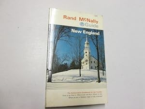
Rand McNally Guide to New England
Edité par Rand MaNally, Chicago, 1971
Vendeur : Sleepy Hollow Books, Huntington, VT, Etats-Unis
Evaluation du vendeur :
Softcover. Pictorial soft cover, minor rubbing, vg condition. Travel/New England; 1593.
-

Rand Mcnally New England
Edité par Rand McNally, 2013
ISBN 10 : 052888185XISBN 13 : 9780528881855
Vendeur : Better World Books, Mishawaka, IN, Etats-Unis
Evaluation du vendeur :
Livre
Etat : Good. Used book that is in clean, average condition without any missing pages.
Plus de choix d'achat de la part d'autres vendeurs sur AbeBooks
Offres d'occasion ŕ partir de EUR 8,56
-

Rand McNally Easy to Fold: New England Laminated Map (Sheet Map, Folded)
Edité par Rand McNally 5/6/2022, 2022
ISBN 10 : 0528026151ISBN 13 : 9780528026157
Vendeur : BargainBookStores, Grand Rapids, MI, Etats-Unis
Evaluation du vendeur :
Livre
Sheet Map, Folded. Etat : New. Rand McNally Easy to Fold: New England Laminated Map 0.35. Book.
Plus de choix d'achat de la part d'autres vendeurs sur AbeBooks
Offres neuf ŕ partir de EUR 9,94
Offres d'occasion ŕ partir de EUR 11,78
Trouvez également Couverture souple
-
RAND McNALLY OFFICIAL JUNIOR AUTO ROAD MAP: NEW ENGLAND
Edité par Rand McNally & Company, Chicago, 1925
Vendeur : Peter L. Masi - books, MONTAGUE, MA, Etats-Unis
Membre d'association : SNEAB
Evaluation du vendeur :

Folding map. Etat : Used - Very Good. Rand McNally & Company, Chicago, no date, ca 1925. 18 x 12" folding map. 5 x 3.25" printed wrapper, advertisements. VG.
-
1920 Map New England|New York Rand McNally Official 1920 auto Trails : District Number 6 : New Eng|Vintage Fine Art Reproduction|Ready to Frame
Edité par New York Map Company LLC, 1920
Vendeur : A Squared Books (Don Dewhirst), South Lyon, MI, Etats-Unis
Evaluation du vendeur :
Kitchen. Etat : Very Good. Boston, 1920; illustrated paper covers; edge and corner wear; 12mo - over 6 3/4" to 7 3/4" tall; fold-out map in very good condition; interior clean and unmarked;
-
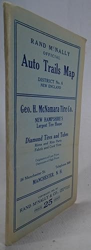
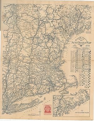
New England and Eastern New York: Rand McNally Official Auto Trails Map, District No. 6
Edité par Rand McNally & Co. 1918, 1918
Vendeur : The Personal Navigator, ROCKPORT, MA, Etats-Unis
Evaluation du vendeur :

1 map 108 x 140 cm. Folded paper map, worn, lightly soiled, fair. Auto trails -- shows early trail markings for automobile roads in days before state and federal highways were numbered as they are today. Map also shows hotels, restaurants and garages for cities. E.g.: For New York City: Hotel Majestic, Broadway & 62nd St. Co. Garage, Biltmore Hotel and Garage, McAlpin Hotel, Joscelyn Garage. For Boston: Hotels Lenox, Brunswick, Puritan, Somerset, American House and Motor Mart Garage.
-
![Image du vendeur pour Rand, McNally & co.'s handy guide to the New England states (1897) [Leatherbound] mis en vente par S N Books World](https://pictures.abebooks.com/inventory/md/md30639189042.jpg)
Rand, McNally & co.'s handy guide to the New England states (1897) [Leatherbound]
Date d'édition : 2022
Livre impression ŕ la demande
Leatherbound. Etat : NEW. Leatherbound edition. Condition: New. Leather Binding on Spine and Corners with Golden leaf printing on spine. Bound in genuine leather with Satin ribbon page markers and Spine with raised gilt bands. A perfect gift for your loved ones. Reprinted from 1897 edition. NO changes have been made to the original text. This is NOT a retyped or an ocr'd reprint. Illustrations, Index, if any, are included in black and white. Each page is checked manually before printing. As this print on demand book is reprinted from a very old book, there could be some missing or flawed pages, but we always try to make the book as complete as possible. Fold-outs, if any, are not part of the book. If the original book was published in multiple volumes then this reprint is of only one volume, not the whole set. IF YOU WISH TO ORDER PARTICULAR VOLUME OR ALL THE VOLUMES YOU CAN CONTACT US. Resized as per current standards. Sewing binding for longer life, where the book block is actually sewn (smythe sewn/section sewn) with thread before binding which results in a more durable type of binding. Pages: 356 Language: English Pages: 356.
-
Rand McNally Guide to New England
Edité par Rand McNally & Company
Vendeur : Goldstone Rare Books, Llandybie, CARMS, Royaume-Uni
Evaluation du vendeur :
Paperback. Etat : Good. Photograph available on request.
-
Rand McNally Offical Auto Trails Map District No. 6 New England
Edité par Rand McNally, Chicago and New York, 1923
Vendeur : Yesterday's Gallery, ABAA, East Woodstock, CT, Etats-Unis
Membre d'association : ABAA ILAB
Evaluation du vendeur :
Soft cover. Small Duodecimo. Large folding map in wrappers. Very good, outter edges of wrappers faded.
-
Rand McNally & Company's Handy Guide to the New England States
Edité par Rand, McNally & Co., Chicago, 1897
Vendeur : Muddy Turtle Books, Fernandina Beach, FL, Etats-Unis
Evaluation du vendeur :
Edition originale
First Edition. Great old ads on first few pages and last few pages. An exeptional copy: the covers have no wear whatsoever. Internally the book is in fine condition and all maps are clean and bright -- none appear to ever have been opened. A near fine copy -- overall c We provide PROTECTIVE packaging. Photos of our books are always available upon request. SELLING USED AND RARE BOOKS ON ABE SINCE 1997 AND IN OUR STORE IN THE BERKSHIRES FROM 1987 TO 2015.
-
Unknown Binding. Etat : Good. Ex-library book, usual markings. Hardback/Hardcover. Original dust cover laminated onto front cover. Clean text, sound binding. Quick dispatch from UK seller.
-
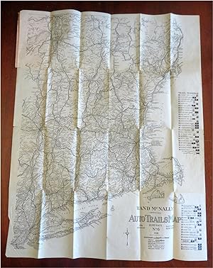
New England & New York Early Automobile Road Atlas 1918 Rand McNally pocket map
Date d'édition : 1918
Vendeur : RareMapsandBooks, Dover, NH, Etats-Unis
Membre d'association : ESA IOBA
Evaluation du vendeur :
Carte
Etat : good. (Old Maps, Americana, United States, New England, Maine, New Hampshire, Vermont, Massachusetts, Connecticut, Rhode Island, New York). Rand-Mc Nally Official Auto Trails Map: District No. 6. New England, Eastern New York. A Guide to the Blazed Trails. Published c. 1918, Chicago by Rand Mc Nally Folding early auto travel map plus wrapper covers. Text in English. Publisher's advertising paper wrappers. Note the many symbols used for roads at this date. Item is old and shows some signs of handling and time. Item is not new or in "new" condition. Paper gently age worn, front cover detached, map still affixed to rear cover as issued, slight rubbing, remains overall clean and attractive as a fragile survival. Paper is lightly toned, signs of handling, small scattered spotting, internally still well preserved, tight, sound. Still attractive on the shelf. The scarce pamphlet displays a pleasing and unique age patina and is in nice antiquarian condition, any age flaws easy to overlook or forgive. Please review photos for more detail and our best attempt to convey how this item survives. Covers measures c. 7 1/4" H x 4 1/4" W. Map sheet c. 28" H x 22" W.[B6118].
-
Rand McNally Official 1920 Auto Trails Map District Number 6 New England Eastern New York - The transition from auto trails to numbered routes.
Date d'édition : 1920
Vendeur : Curtis Wright Maps, Berwyn, IL, Etats-Unis
Membre d'association : ESA MWABA
Evaluation du vendeur :
Etat : Very Good. "This engaging road map covers a broad region along the Atlantic coast between New York and Maine, with an inset in the lower right extending the image to the Canadian border. It was published in Chicago, Illinois by Rand McNally in 1920 and distributed to promote the products of the Socony Oil Company, one of the 34 operators established as a result of Standard Oil's Supreme Court-mandated dissolution in 1911. Nearly 100 different markings for various auto trails are identified immediately below the title block, reflecting the decentralized and haphazard method of organizing and promoting road construction. Though Wisconsin established numbered state highways in 1917, it wasn't until the Federal Aid Highway Act of 1921 (The Phipps Act) that a coherent plan for the nation's roads was first proposed. Distances between points are noted and several advertisements for Socony products can be seen on the covers and within the image. Source." Sheet Width (in) 21.75 Sheet Height (in) 27.75 Condition Description Pocket map folded into 24 panels and affixed to original stiff illustrated paper wraps. Light creasing and some moderate toning along fold lines, and scattered soiling in the upper left (where affixed to the covers), in the lower left (near Long Island), and in the upper right (in the margin). Good to very good overall.