
Montant total (1 article articles) :
Destination de la commande :

road dublin sligo longford de taylor skinner (7 résultats)
Votre recherche :
Auteur :
taylor skinner
,
Titre :
road dublin sligo longford
Modifier votre recherche
Passer aux résultats principaux de la recherche
Type d'article
- Tous les types d'articles
- Livres
- Magazines & Périodiques
- Bandes dessinées
- Partitions de musique
- Art, Affiches et Gravures
- Photographies
- Cartes (7)
-
Manuscrits &
Papiers anciens
Etat
- Tous
- Neuf
- Ancien ou d'occasion
Reliure
- Toutes
- Couverture rigide
- Couverture souple
Particularités
- Edition originale
- Signé
- Jaquette
- Avec images
- Sans impression ŕ la demande
Pays
Evaluation du vendeur
-
Etat : Good. #63 To Sligo by Longford. Edgeworthstown Newtownforbes. TAYLOR/SKINNER 1778 map. Antique copperplate road map; George Taylor & Andrew Skinner (1778). 23.0 x 13.0cm, 9 x 5.25 inches. Condition: Good. There is another map printed on the reverse side: #64 [Road] from Dublin [to Sligo by Longford] which includes the towns of Carrick-on-Shannon, Drumsna, Boyle, Ballinafad, Jamestown and covers part of the counties of Leitrim, Sligo, Roscommon. The map includes the towns of Edgeworthstown, Roosky, Newtownforbes, Longford, Ballinalack, Dromod and covers part of the counties of Longford, Leitrim, Westmeath, Roscommon.
-
Etat : Good. #64 Carrick/Shannon Drumsna Boyle Ballinafad Jamestown. TAYLOR/SKINNER 1778 map. Antique copperplate road map; George Taylor & Andrew Skinner (1778). 23.0 x 13.0cm, 9 x 5 inches. Condition: Good. There is another map printed on the reverse side: #63 [Road from Dublin] to Sligo by Longford which includes the towns of Edgeworthstown, Roosky, Newtownforbes, Longford, Ballinalack, Dromod and covers part of the counties of Longford, Leitrim, Westmeath, Roscommon. The map includes the towns of Carrick-on-Shannon, Drumsna, Boyle, Ballinafad, Jamestown and covers part of the counties of Leitrim, Sligo, Roscommon.
-
Etat : Good. #65 [Road from Dublin] to Sligo by Longford. Collooney. TAYLOR/SKINNER 1778 map. Antique copperplate road map; George Taylor & Andrew Skinner (1778). 23.0 x 13.0cm, 9 x 5.25 inches. Condition: Good. There is another map printed on the reverse side: #66 Road from Dublin to Killala to Roscommon by Lanesboro & to Boyle by Strokestown which includes the towns of Mullingar, Rathconrath and covers part of the county of Westmeath. The map includes the towns of Sligo, Collooney and covers part of the county of Sligo.
-
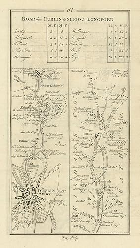
Etat : Good. #61 Dublin to Sligo. Palmerstown Maynooth Kilcock Lucan. TAYLOR/SKINNER 1778 map. Antique copperplate road map; George Taylor & Andrew Skinner (1778). 23.0 x 13.0cm, 9 x 5 inches. Condition: Good. There is another map printed on the reverse side: #62 [Road] from Dublin [to Sligo by Longford] which includes the towns of Kinnegad, Mullingar and covers part of the county of Westmeath. The map includes the towns of Dublin, Palmerstown, Maynooth, Kilcock, Lucan and covers part of the counties of Dublin, Kildare.
-
Etat : Good. #62 Dublin to Sligo by Longford. Kinnegad Mullingar. TAYLOR/SKINNER 1778 map. Antique copperplate road map; George Taylor & Andrew Skinner (1778). 23.0 x 13.0cm, 9 x 5 inches. Condition: Good. There is another map printed on the reverse side: #61 Road from Dublin to Sligo by Longford which includes the towns of Dublin, Palmerstown, Maynooth, Kilcock, Lucan and covers part of the counties of Dublin, Kildare. The map includes the towns of Kinnegad, Mullingar and covers part of the county of Westmeath.
-
![Image du vendeur pour Road from Dublin to Sligo by Longford. [and on verso] From Dublin [To Sligo by Longford]. mis en vente par Robert Frew Ltd. ABA ILAB](https://pictures.abebooks.com/inventory/md/md17237132308.jpg)
Road from Dublin to Sligo by Longford. [and on verso] From Dublin [To Sligo by Longford].
Edité par Originally published for the Authors.Sold by T. Longman. London and W. Wilson. Dublin., 1783
Vendeur : Robert Frew Ltd. ABA ILAB, London, Royaume-Uni
Membre d'association : ABA ILAB PBFA
Evaluation du vendeur :

Carte
(25 x 14.5 cm). Uncoloured. Original copper engraved road maps printed on the recto and in two columns on the verso. Table of distances above maps on the recto. Both sides clean and in good condition.
-
![Image du vendeur pour [Road from Dublin] to Sligo by Longford. [and on verso] Road from Dublin to Killala To Roscommon by Lanesboro & to Boyle by Strokestown. mis en vente par Robert Frew Ltd. ABA ILAB](https://pictures.abebooks.com/inventory/md/md17237132309.jpg)
[Road from Dublin] to Sligo by Longford. [and on verso] Road from Dublin to Killala To Roscommon by Lanesboro & to Boyle by Strokestown.
Edité par Originally published for the Authors.Sold by T. Longman. London and W. Wilson. Dublin., 1783
Vendeur : Robert Frew Ltd. ABA ILAB, London, Royaume-Uni
Membre d'association : ABA ILAB PBFA
Evaluation du vendeur :
Carte
(25 x 14.5 cm). Uncoloured. Original copper engraved road maps printed on the recto and on the verso. Table of distances above map on the verso. Both sides clean and in good condition.
![Image du vendeur pour [Road from Dublin] to Sligo by Longford mis en vente par Antiqua Print Gallery](https://pictures.abebooks.com/inventory/md/md31423935280.jpg)
![Image du vendeur pour [Road] from Dublin [to Sligo by Longford] mis en vente par Antiqua Print Gallery](https://pictures.abebooks.com/inventory/md/md31423937191.jpg)
![Image du vendeur pour [Road from Dublin] to Sligo by Longford mis en vente par Antiqua Print Gallery](https://pictures.abebooks.com/inventory/md/md31423938177.jpg)
![Image du vendeur pour [Road] from Dublin [to Sligo by Longford] mis en vente par Antiqua Print Gallery](https://pictures.abebooks.com/inventory/md/md31423932576.jpg)