Montant total (1 article articles) :
Destination de la commande :

russia europe de dower (7 résultats)
Passer aux résultats principaux de la recherche
Type d'article
- Tous les types d'articles
- Livres (4)
- Magazines & Périodiques
- Bandes dessinées
- Partitions de musique
- Art, Affiches et Gravures
- Photographies
- Cartes (2)
-
Manuscrits &
Papiers anciens (1)
Etat
- Tous
- Neuf
- Ancien ou d'occasion
Reliure
- Toutes
- Couverture rigide
- Couverture souple (1)
Particularités
- Edition originale
- Signé
- Jaquette
- Avec images (6)
- Sans impression ŕ la demande
Livraison gratuite
Pays
Evaluation du vendeur
-

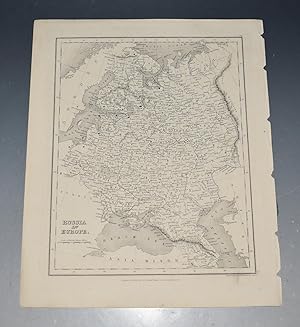
Russia in Europe (1862)
Edité par Paris, 1862
Vendeur : Waimakariri Books and Prints Limited, Oxford, Nouvelle-Zélande
Evaluation du vendeur :

Carte
No Binding. Etat : Very Good. Russia in Europe, a small map from James Cornwell A School Atlas, published in London in 1862. Image size 84 x 142 mm approx, left margin tight. Very Good - light handling wear and marks. Price includes standard airmail worldwide.
-
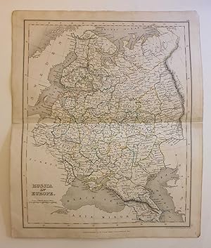
Russia in Europe, c.1855 Hand-Coloured Original Map Engraving
Edité par Simpkin & Marshall, UK, 1855
Livre
Softcover. Etat : Good. c.1855. A well-presented engraving, with some mild spotting and handling marks around the outer margins, a few faint spots of foxing but generally clean across the printed image surface. Horizontal fold line is beginning to split from the edges but has been reinforced with conservation tape to prevent any worsening. Why on Amazon do most sellers not describe their actual book? Buy with confidence and support a genuine Independent Bricks & Mortar Real Bookshop. We are Maynard & Bradley CAMBO & PBFA(now lapsed) members here in Leicester City Centre. Size: 285 x 240 mm. 1. Text is in German. Item Type: Book. Quantity Available: 1. Shipped Weight: Under 500 grams. Category: Geography & Maps; Britain/UK; 19th century; German Language; Inventory No: 36412.
-
RUSSIA in EUROPE.
Edité par Orr & Comp Amen Corner Paternoster Row Ca1870, 1870
Vendeur : PROCTOR / THE ANTIQUE MAP & BOOKSHOP, DORCHESTER, Royaume-Uni
Membre d'association : PBFA
Evaluation du vendeur :
Size of engraved surface: 25cm x 30cm. In very good condition. Faint mark lower right corner. Uncoloured.
-
Russia and Europe. (19th Century Map).
Edité par London: Henry Teesdale, [1800s]., 1800
Vendeur : Wittenborn Art Books, San Francisco, CA, Etats-Unis
Evaluation du vendeur :
Manuscrit / Papier ancien
Etat : Good. 15 x 19 inches. Very Good. Three inch tear at right, and one inch tear at left edges along fold. 19th Century, folded map, printed in color.
-

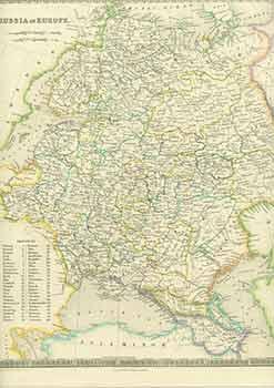
Russia in Europe.
Edité par A New General Atlas of the World. Published by Henry Teesdale. 1831, 1831
Vendeur : Peter Harrington. ABA/ ILAB., London, Royaume-Uni
Membre d'association : ABA ILAB PBFA
Evaluation du vendeur :
The map includes Finland, Poland, down to the Black Sea Copper engraving. Original colour. In fine, clean condition. Size:33 x 40.5cm. (16 x 13 inches).
-
Russia in Europe.
Edité par LondonHenry Teesdale & Co., 1844
Vendeur : Robert Frew Ltd. ABA ILAB, London, Royaume-Uni
Membre d'association : ABA ILAB PBFA
Evaluation du vendeur :
Carte
(47.5 x 38.5 cm). Original engraved map of European Russia with original hand colouring.
-
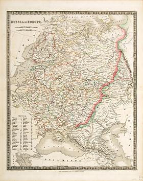
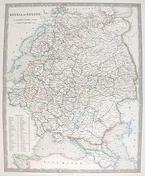
RUSSIA IN EUROPE 9.
Edité par A New General Atlas of the World,. Henry Teesdale & co. 302, High Holborn,. March 1835., 1835
Vendeur : Peter Harrington. ABA/ ILAB., London, Royaume-Uni
Membre d'association : ABA ILAB PBFA
Evaluation du vendeur :
Full title - A new General Atlas of the World, Compiled from the latest authorities both English and Foreign, Containing separate Maps of its various Countries & States, and exhibiting their boundaries & Divisions, also the Chains of Mountains, Rivers, Lakes and other Goegraphical Features, Comprehended in Forty Six Maps, Including Ancient Maps of Greece, the Roman and Persian Empires & Palestine, from Drawings made Expressly for this work, By John Dower. Paper watermarked J. Whatman 1834. With coloured margins of countries. Shows cities, place names, roads, rivers, lakes, and islands Copper engraving. Original colour. Very good condition. Size: 35 x 43 cm. (14 x 17 inches).