
Montant total (1 article articles) :
Destination de la commande :

rutland water challenge map de brawn david (16 résultats)
Votre recherche :
Auteur :
brawn david
,
Titre :
rutland water challenge map
Modifier votre recherche
Passer aux résultats principaux de la recherche
Type d'article
- Tous les types de produits
- Livres (15)
- Magazines & Périodiques
- Bandes dessinées
- Partitions de musique
- Art, Affiches et Gravures
- Photographies
- Cartes (1)
- Manuscrits & Papiers anciens
Etat
Reliure
- Toutes
- Couverture rigide
- Couverture souple (1)
Particularités
- Ed. originale
- Signé
- Jaquette
- Avec images (3)
- Sans impressions ŕ la demande (16)
Livraison gratuite
- Frais de port gratuits USA
Pays
Evaluation du vendeur
-

Etat : As New. Unread book in perfect condition.
-
Etat : New.
-

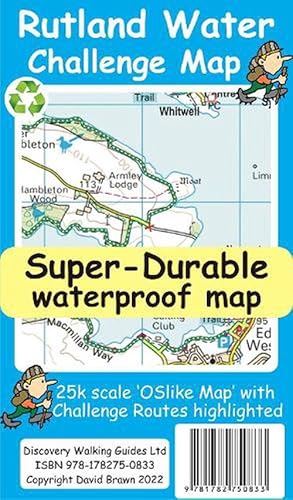
Rutland Water Challenge Map and Guide (Map)
Edité par Discovery Walking Guides Ltd, Northampton, 2022
ISBN 10 : 1782750835ISBN 13 : 9781782750833
Vendeur : Grand Eagle Retail, Wilmington, DE, Etats-Unis
Evaluation du vendeur :

Livre
Map. Etat : new. Map. Rutland Water is the UK's largest man-made lake set in 4,200 acres of parkland including a wide, hard surfaced, walkway making the 'Water' an ideal introduction to long distance walking. There are four official, family friendly, recreation centres and nature reserves including the Rutland Osprey Project. Add in picturesque villages and the town of Oakham and you will soon understand why Rutland Water has become one of England's favourite 'Daycation' destinations.Rutland Water Challenge Map and Guide is a 25k scale OSlike map with the Challenge route specially highlighted. We licence OS 50k scale mapping which is then doubled in size to produce an OSlike 25k map but the features, text and logos are now doubled in size making them much easier to read under Challenge conditions. Rutland Water Challenge Route is added and specially highlighted so that our route stands out against the OSlike 25k map. Then we add the additional detail you might need including local hostelries along with the three walking routes; Hambleton Peninsula 8.3kms, Circular 24.5kms and the full Challenge route at 36kms. For each of the three routes we have gps track and waypoints as a gpx file; the zip file of the gpx files is available as a free download. These gps track and waypoints gpx files can be used on all gps phone apps and gps units. The 33 waypoints of the full Challenge route are highlighted on the map, and our Rutland Water Challenge Map is available as a free digital Custom Map download for Garmin gps users.On the reverse of the map sheet is our Locator Map using OS Opendata showing the location of, and access to, Rutland Water relative to a wide area of England. The result is a double sided 600mm by 600mm map design. We then print the map design on a 100 micron plastic substrate using a special UV curing inks process on the UK's only press capable of using this latest technology. The result is a lightweight map that is both waterproof and tearproof, and fully recyclable, that will survive anything your Rutland Water Challenge can throw at it and afterwards will fold up like new. Rutland Water is the UK's largest man-made lake set in 4,200 acres of parkland including a wide, hard surfaced, walkway making the 'Water' an ideal introduction to long distance walking. Rutland Water Challenge Map and Guide is a 25k scale OSlike map with the Challenge route specially highlighted. Shipping may be from multiple locations in the US or from the UK, depending on stock availability.
-
Rutland Water Challenge Map and Guide
Edité par Discovery Walking Guides Ltd 2022-07-18, 2022
ISBN 10 : 1782750835ISBN 13 : 9781782750833
Livre
sheet map. Etat : New.
-
Rutland Water Challenge Map and Guide
Edité par Discovery Walking Guides Ltd, 2022
ISBN 10 : 1782750835ISBN 13 : 9781782750833
Livre
UNK. Etat : New. New Book. Shipped from UK. Established seller since 2000.
-
Rutland Water Challenge Map and Guide
Edité par Discovery Walking Guides Ltd, 2022
ISBN 10 : 1782750835ISBN 13 : 9781782750833
Livre
Map. Etat : New. BRAND NEW ** SUPER FAST SHIPPING FROM UK WAREHOUSE ** 30 DAY MONEY BACK GUARANTEE.
-
Rutland Water Challenge Map and Guide
Edité par Discovery Walking Guides Ltd, 2022
ISBN 10 : 1782750835ISBN 13 : 9781782750833
Carte
Map. Etat : Brand New. 30 pages. 8.66x4.72x0.20 inches. In Stock.
-
Rutland Water Challenge Map and Guide
Edité par Discovery Walking Guides Ltd
ISBN 10 : 1782750835ISBN 13 : 9781782750833
Livre
Sheet map. Etat : New. New copy - Usually dispatched within 4 working days.
-
Rutland Water Challenge Map and Guide
Edité par Discovery Walking Guides Ltd, 2022
ISBN 10 : 1782750835ISBN 13 : 9781782750833
Vendeur : Kennys Bookshop and Art Galleries Ltd., Galway, GY, Irlande
Evaluation du vendeur :
Livre
Etat : New. 2022. Map. . . . . .
-
Rutland Water Challenge Map and Guide
Edité par Discovery Walking Guides Ltd
ISBN 10 : 1782750835ISBN 13 : 9781782750833
Livre
Etat : New. 2022. Map. . . . . . Books ship from the US and Ireland.
-
Rutland Water Challenge Map And Guide
ISBN 10 : 1782750835ISBN 13 : 9781782750833
Vendeur : GreatBookPricesUK, Castle Donington, DERBY, Royaume-Uni
Evaluation du vendeur :
Livre
Etat : New.
-
Rutland Water Challenge Map And Guide
ISBN 10 : 1782750835ISBN 13 : 9781782750833
Vendeur : GreatBookPricesUK, Castle Donington, DERBY, Royaume-Uni
Evaluation du vendeur :
Livre
Etat : As New. Unread book in perfect condition.
-
Rutland Water Challenge Map and Guide
Edité par Discovery Walking Guides Ltd, 2022
ISBN 10 : 1782750835ISBN 13 : 9781782750833
Livre
UNK. Etat : New. New Book. Shipped from UK. Established seller since 2000.
-
Rutland Water Challenge Map and Guide
Edité par Discovery Walking Guides Ltd Jul 2022, 2022
ISBN 10 : 1782750835ISBN 13 : 9781782750833
Livre
Karte. Etat : Neu. Neuware - Rutland Water is the UK's largest man-made lake set in 4,200 acres of parkland including a wide, hard surfaced, walkway making the 'Water' an ideal introduction to long distance walking. Rutland Water Challenge Map and Guide is a 25k scale OSlike map with the Challenge route specially highlighted. 30 pp. Deutsch.
-
Rutland Water Challenge Map and Guide (Map)
Edité par Discovery Walking Guides Ltd, Northampton, 2022
ISBN 10 : 1782750835ISBN 13 : 9781782750833
Livre
Map. Etat : new. Map. Rutland Water is the UK's largest man-made lake set in 4,200 acres of parkland including a wide, hard surfaced, walkway making the 'Water' an ideal introduction to long distance walking. There are four official, family friendly, recreation centres and nature reserves including the Rutland Osprey Project. Add in picturesque villages and the town of Oakham and you will soon understand why Rutland Water has become one of England's favourite 'Daycation' destinations.Rutland Water Challenge Map and Guide is a 25k scale OSlike map with the Challenge route specially highlighted. We licence OS 50k scale mapping which is then doubled in size to produce an OSlike 25k map but the features, text and logos are now doubled in size making them much easier to read under Challenge conditions. Rutland Water Challenge Route is added and specially highlighted so that our route stands out against the OSlike 25k map. Then we add the additional detail you might need including local hostelries along with the three walking routes; Hambleton Peninsula 8.3kms, Circular 24.5kms and the full Challenge route at 36kms. For each of the three routes we have gps track and waypoints as a gpx file; the zip file of the gpx files is available as a free download. These gps track and waypoints gpx files can be used on all gps phone apps and gps units. The 33 waypoints of the full Challenge route are highlighted on the map, and our Rutland Water Challenge Map is available as a free digital Custom Map download for Garmin gps users.On the reverse of the map sheet is our Locator Map using OS Opendata showing the location of, and access to, Rutland Water relative to a wide area of England. The result is a double sided 600mm by 600mm map design. We then print the map design on a 100 micron plastic substrate using a special UV curing inks process on the UK's only press capable of using this latest technology. The result is a lightweight map that is both waterproof and tearproof, and fully recyclable, that will survive anything your Rutland Water Challenge can throw at it and afterwards will fold up like new. Rutland Water is the UK's largest man-made lake set in 4,200 acres of parkland including a wide, hard surfaced, walkway making the 'Water' an ideal introduction to long distance walking. Rutland Water Challenge Map and Guide is a 25k scale OSlike map with the Challenge route specially highlighted. Shipping may be from our UK warehouse or from our Australian or US warehouses, depending on stock availability.
-

Rutland Water Challenge Map and Guide
Edité par Discovery Walking Guides Ltd, 2022
ISBN 10 : 1782750835ISBN 13 : 9781782750833
Livre
Karte/Landkarte. Etat : New. KlappentextrnrnRutland Water is the UK s largest man-made lake set in 4,200 acres of parkland including a wide, hard surfaced, walkway making the Water an ideal introduction to long distance walking. Rutland Water Challenge Map and Guide is a .