Montant total (1 article articles) :
Destination de la commande :

vieux mexique nouvelle espagne costes de fer nicolas (4 résultats)
Passer aux résultats principaux de la recherche
Type d'article
- Tous les types d'articles
- Livres (2)
- Magazines & Périodiques
- Bandes dessinées
- Partitions de musique
- Art, Affiches et Gravures (1)
- Photographies
- Cartes (1)
-
Manuscrits &
Papiers anciens
Etat
- Tous
- Neuf
- Ancien ou d'occasion
Reliure
- Toutes
- Couverture rigide
- Couverture souple
Particularités
- Edition originale (1)
- Signé
- Jaquette
- Avec images (2)
- Sans impression ŕ la demande
Pays
Evaluation du vendeur
-
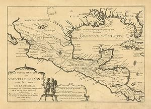
Le vieux Mexique ou Nouvelle Espagne avec les costes de la Floride
Edité par America - Messico, Florida
Vendeur : Sergio Trippini, Gavirate, Italie
Membre d'association : ALAI ILAB
Evaluation du vendeur :

Carta geografica in cui sono raffigurati i territori della Florida, il Texas ed il Messico. Sia lungo la linea costiera che il territorio del Texas si rifanno alle esplorazioni di La Salle.
-
Le vieux Mexique ou Nouvelle Espagne avec les costes de la Floride.
Edité par Parigi,, 1705
Vendeur : libreria antiquaria perini Sas di Perini, Verona, VR, Italie
Membre d'association : ALAI ILAB
Evaluation du vendeur :
Art / Affiche / Gravure
Copper engraving, mm 232x330. Attractive small map covering the Gulf of Mexico through Central America also including parts of Cuba and Jamaica. It extends through Mexico to show the southern tip of Baja California. This is an early map to show the correct location of the Mississippi River delta gleaned from the expeditions of La Salle and Iberville. Almost all prior maps had the mouth further west into present-day Texas. The Rio Grande (Rio Bravo ou del Nord) is also shown flowing correctly into the Gulf of Mexico rather than into the Gulf of California. Two French forts are located: LaSalle's Fort St. Louis in Texas (Fortbati en 1685) and another near present-day New Orleans. One of the prominent features in northern Mexico is Les Fameuses Mines de Ste. Barbe, the legendary Santa Barbara mines of the Chihuahua-Durango region. The cartouche features two native figures. Nicolas de Fer (1646-1720) was a leading frech engraver and cartographer, official geographer of the king of France. Good condition. Nr.cat: P8190011.
-

Le Vieux Mexique ou Nouvelle Espagne Avec les Costes de la Floride Faisant-Partie De L?amerique Septentrionale
Edité par Paris, 1705
Vendeur : Alexandre Antique Prints, Maps & Books, Toronto, ON, Canada
Membre d'association : ABAC ILAB
Evaluation du vendeur :

Carte
Etat : Excellent. This map covers the Gulf of Mexico through Central America and includes parts of Cuba and Jamaica. It extends through Mexico to show the southern tip of Baja California. This is an early map to show the correct location of the Mississippi River delta gleaned from the expeditions of La Salle and Iberville. Two French forts are located: LaSalle\\\\\\\'s Fort St. Louis in Texas (Fortbati en 1685) and another near present-day New Orleans. One of the prominent features in northern Mexico is Les Fameuses Mines de Ste. Barbe, the legendary Santa Barbara mines of the Chihuahua-Durango region., Size : 230x335 (mm), 9x13.125 (Inches), Original Outline Coloring.
-
[Map] Le Vieux Mexique ou Nouvelle Espagne avec les costes de la Floride
Edité par Chez l'Auteur, Paris, 1702
Vendeur : PLAZA BOOKS ABAA, Port Townsend, WA, Etats-Unis
Membre d'association : ABAA ILAB
Evaluation du vendeur :
Edition originale
First printing. Map, folio sheet, 12.75"x9" (23x33cm). Copperplate engraving. Significant early map of this area, locating the mouth of the Mississippi correctly , as taken from the information reported by M. La Salle. The right edge includes all of Florida and most of Cuba; the left cuts off most of Baja California. Santa Fe (New Mexico) is shown at the top, the bottom cuts off at the Isthmus of Panama. Attractive cartouche showing two Indians in full regalia. Hand-colored, probably contemporaneously. Fine copy.