
Montant total (1 article articles) :
Destination de la commande :

gerard cornelis jode (32 résultats)
Passer aux résultats principaux de la recherche
Type d'article
- Tous les types d'articles
- Livres
- Magazines & Périodiques
- Bandes dessinées
- Partitions de musique
- Art, Affiches et Gravures (31)
- Photographies
- Cartes (1)
-
Manuscrits &
Papiers anciens
Etat
- Tous
- Neuf
- Ancien ou d'occasion
Reliure
- Toutes
- Couverture rigide (1)
- Couverture souple
Particularités
- Edition originale
- Signé
- Jaquette
- Avec images
- Sans impression ŕ la demande
Pays
Evaluation du vendeur
-

Map of the La Mans Region, France (Nova et Integra Caenomaniae Descriptio Vulg. La Mans)
Edité par Antwerp, 1593
Vendeur : Trillium Antique Prints & Rare Books, Franklin, TN, Etats-Unis
Evaluation du vendeur :

Art / Affiche / Gravure
Etat : Fine. This truly significant map is from one of the rarest atlases ever published, Gerard and Cornelis de Jode's Speculum orbis Terrae. The work was published in Antwerp in 1593 by Arnold Coninx for the widow and heirs. This is considered the second edition, revised an expanded. The first edition was published in 1578. Van Ortroy knew of only 14 copies of the second edition being published. (Skelton, Introduction to the facsimile editions)De Jode drew upon his large stock of maps from Italian, German, and Flemish cartographers to create his atlas. He engraved some of the maps and his brothers, Joannes and Lucas van Deutecum, also contributed to the process. The second edition included additional maps from Gerard's son Cornelis. The maps have descriptive text to verso in Latin. The text for the first edition was written by the German scholar, Daniel Cellarius.The atlas contained some of the most groundbreaking maps ever published. The maps of the world, Americas, Australia, and China are of particular note and remain some of the most important maps ever published. While it may not have had commercial success at the time, it is considered a masterpiece of 16th century cartography. Very few examples of the maps have survived from either edition.Gerard de Jode (1521- 1591) was a Flemish cartographer, printer, and engraver. He produced and sold many maps in Antwerp, but his legacy lies in his outstanding atlas, Speculum Orbis Terrarum. De Jode was a contemporary and competitor of Abraham Ortelius. Ortelius was believed to have been responsible for delaying de Jode's work so his atlas Theatrum Orbis Terrarum would precede de Jode's. Because Ortelius's atlas had 8 years on the market it was well established and thus de Jode's atlas did not sell very well.To compete with Ortelius, de Jode worked on the second revised and expanded edition. De Jode's wife and son, Cornelis (1568-1600) took over the publishing upon Gerard's death in 1591. Cornelis prepared ten new maps of the World, North America, China, Australia and Alaska and re-issued the atlas. "Many of de Jodeâ s maps are judged to be superior to those of Ortelius, both in detail and style." (Burden)Antwerp publisher Joan Baptista Vrients purchased the plates after Cornelis's death. He also acquired Ortelius's plates for Theatrum Orbis Terrarum to which he gave priority. It is likely he bought de Jode's plates to prevent any further editions of Speculum of course only increasing the intrigue and worth of the maps today."Although the atlas may not have appealed to the public, it was admired by other cartographers. As evidence, Petrus Montanus mentions it in the same breath with Mercatorâ s Atlas and Orteliusâ Theatrum in his preface to Pieter Kaeriusâ Germaniae inferior (Wardington Catalogue), Michael von Aitzing refers to it in his work, DeLeone Belgico (1583). Von Aitzing intended his work to act also as a supplement to both the Theatrum of Ortelius and the Speculum of De Jode." (Burden)Provenance : Ownership inscription at the bottom of the title page ex Bibliotheca Prim d Federici 1600.References: Van der Krogt 32:02B (titles 32:2A and 32:2B) ; Koeman II, Jod 2 ; Shirley, The mapping of the world, 165,184 ; Burden, The mapping of America, 81, 82 ; Symour, L. Schwartz, Ehrenberg, The mapping of America, pp. 78-79 ; Norwich, Maps of Africa 19 ; Navari, Maps of Cyprus, 29 ; Tooley, Dictionnary of mapmakers II, p. 441 ; Tooley, Mapping of Australia,; Tooley, Arabia in early maps, 38 (1st ed.) ; Koeman, Schilder, van Egmond, van der Krogt, HOC,vol. 3 part 2, Commercial Cartography and Map Production in the Low Countries, 1500 â " ca. 1672, pp. 1321-1323 ; Ortroy, Fern van, Lâ oeuvre cartographique de Gerard et de Corneille de Jode, Gand 1914, 82-121. --- The work is in very good to excellent condition overall. The maps from this work are truly in remarkable condition for the age. While some faint offset or minor marks or imperfections can be expected, they generally.
-
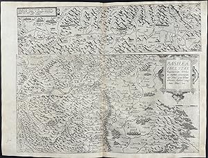
Maps of Canton Valais & Basel, Switzerland (Valesiae Provinciae Montanae Itaiam, Galliam, ac Germaniamâ ¦ & Basileae Inclytae Rauracorum Urbisâ ¦)
Edité par Antwerp, 1593
Vendeur : Trillium Antique Prints & Rare Books, Franklin, TN, Etats-Unis
Evaluation du vendeur :
Art / Affiche / Gravure
Etat : Fine. This truly significant map is from one of the rarest atlases ever published, Gerard and Cornelis de Jode's Speculum orbis Terrae. The work was published in Antwerp in 1593 by Arnold Coninx for the widow and heirs. This is considered the second edition, revised an expanded. The first edition was published in 1578. Van Ortroy knew of only 14 copies of the second edition being published. (Skelton, Introduction to the facsimile editions)De Jode drew upon his large stock of maps from Italian, German, and Flemish cartographers to create his atlas. He engraved some of the maps and his brothers, Joannes and Lucas van Deutecum, also contributed to the process. The second edition included additional maps from Gerard's son Cornelis. The maps have descriptive text to verso in Latin. The text for the first edition was written by the German scholar, Daniel Cellarius.The atlas contained some of the most groundbreaking maps ever published. The maps of the world, Americas, Australia, and China are of particular note and remain some of the most important maps ever published. While it may not have had commercial success at the time, it is considered a masterpiece of 16th century cartography. Very few examples of the maps have survived from either edition.Gerard de Jode (1521- 1591) was a Flemish cartographer, printer, and engraver. He produced and sold many maps in Antwerp, but his legacy lies in his outstanding atlas, Speculum Orbis Terrarum. De Jode was a contemporary and competitor of Abraham Ortelius. Ortelius was believed to have been responsible for delaying de Jode's work so his atlas Theatrum Orbis Terrarum would precede de Jode's. Because Ortelius's atlas had 8 years on the market it was well established and thus de Jode's atlas did not sell very well.To compete with Ortelius, de Jode worked on the second revised and expanded edition. De Jode's wife and son, Cornelis (1568-1600) took over the publishing upon Gerard's death in 1591. Cornelis prepared ten new maps of the World, North America, China, Australia and Alaska and re-issued the atlas. "Many of de Jodeâ s maps are judged to be superior to those of Ortelius, both in detail and style." (Burden)Antwerp publisher Joan Baptista Vrients purchased the plates after Cornelis's death. He also acquired Ortelius's plates for Theatrum Orbis Terrarum to which he gave priority. It is likely he bought de Jode's plates to prevent any further editions of Speculum of course only increasing the intrigue and worth of the maps today."Although the atlas may not have appealed to the public, it was admired by other cartographers. As evidence, Petrus Montanus mentions it in the same breath with Mercatorâ s Atlas and Orteliusâ Theatrum in his preface to Pieter Kaeriusâ Germaniae inferior (Wardington Catalogue), Michael von Aitzing refers to it in his work, DeLeone Belgico (1583). Von Aitzing intended his work to act also as a supplement to both the Theatrum of Ortelius and the Speculum of De Jode." (Burden)Provenance : Ownership inscription at the bottom of the title page ex Bibliotheca Prim d Federici 1600.References: Van der Krogt 32:02B (titles 32:2A and 32:2B) ; Koeman II, Jod 2 ; Shirley, The mapping of the world, 165,184 ; Burden, The mapping of America, 81, 82 ; Symour, L. Schwartz, Ehrenberg, The mapping of America, pp. 78-79 ; Norwich, Maps of Africa 19 ; Navari, Maps of Cyprus, 29 ; Tooley, Dictionnary of mapmakers II, p. 441 ; Tooley, Mapping of Australia,; Tooley, Arabia in early maps, 38 (1st ed.) ; Koeman, Schilder, van Egmond, van der Krogt, HOC,vol. 3 part 2, Commercial Cartography and Map Production in the Low Countries, 1500 â " ca. 1672, pp. 1321-1323 ; Ortroy, Fern van, Lâ oeuvre cartographique de Gerard et de Corneille de Jode, Gand 1914, 82-121. --- The work is in very good to excellent condition overall. The maps from this work are truly in remarkable condition for the age. While some faint offset or minor marks or imperfections can be expected, they generally.
-

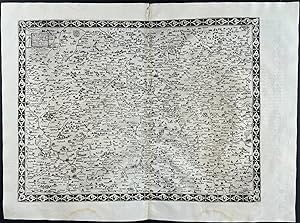
Map of the Duchy of Anjou, France (Exacta novaque descriptio ducatus Andegavensis)
Edité par Antwerp, 1593
Vendeur : Trillium Antique Prints & Rare Books, Franklin, TN, Etats-Unis
Evaluation du vendeur :
Art / Affiche / Gravure
Etat : Fine. This truly significant map is from one of the rarest atlases ever published, Gerard and Cornelis de Jode's Speculum orbis Terrae. The work was published in Antwerp in 1593 by Arnold Coninx for the widow and heirs. This is considered the second edition, revised an expanded. The first edition was published in 1578. Van Ortroy knew of only 14 copies of the second edition being published. (Skelton, Introduction to the facsimile editions)De Jode drew upon his large stock of maps from Italian, German, and Flemish cartographers to create his atlas. He engraved some of the maps and his brothers, Joannes and Lucas van Deutecum, also contributed to the process. The second edition included additional maps from Gerard's son Cornelis. The maps have descriptive text to verso in Latin. The text for the first edition was written by the German scholar, Daniel Cellarius.The atlas contained some of the most groundbreaking maps ever published. The maps of the world, Americas, Australia, and China are of particular note and remain some of the most important maps ever published. While it may not have had commercial success at the time, it is considered a masterpiece of 16th century cartography. Very few examples of the maps have survived from either edition.Gerard de Jode (1521- 1591) was a Flemish cartographer, printer, and engraver. He produced and sold many maps in Antwerp, but his legacy lies in his outstanding atlas, Speculum Orbis Terrarum. De Jode was a contemporary and competitor of Abraham Ortelius. Ortelius was believed to have been responsible for delaying de Jode's work so his atlas Theatrum Orbis Terrarum would precede de Jode's. Because Ortelius's atlas had 8 years on the market it was well established and thus de Jode's atlas did not sell very well.To compete with Ortelius, de Jode worked on the second revised and expanded edition. De Jode's wife and son, Cornelis (1568-1600) took over the publishing upon Gerard's death in 1591. Cornelis prepared ten new maps of the World, North America, China, Australia and Alaska and re-issued the atlas. "Many of de Jodeâ s maps are judged to be superior to those of Ortelius, both in detail and style." (Burden)Antwerp publisher Joan Baptista Vrients purchased the plates after Cornelis's death. He also acquired Ortelius's plates for Theatrum Orbis Terrarum to which he gave priority. It is likely he bought de Jode's plates to prevent any further editions of Speculum of course only increasing the intrigue and worth of the maps today."Although the atlas may not have appealed to the public, it was admired by other cartographers. As evidence, Petrus Montanus mentions it in the same breath with Mercatorâ s Atlas and Orteliusâ Theatrum in his preface to Pieter Kaeriusâ Germaniae inferior (Wardington Catalogue), Michael von Aitzing refers to it in his work, DeLeone Belgico (1583). Von Aitzing intended his work to act also as a supplement to both the Theatrum of Ortelius and the Speculum of De Jode." (Burden)Provenance : Ownership inscription at the bottom of the title page ex Bibliotheca Prim d Federici 1600.References: Van der Krogt 32:02B (titles 32:2A and 32:2B) ; Koeman II, Jod 2 ; Shirley, The mapping of the world, 165,184 ; Burden, The mapping of America, 81, 82 ; Symour, L. Schwartz, Ehrenberg, The mapping of America, pp. 78-79 ; Norwich, Maps of Africa 19 ; Navari, Maps of Cyprus, 29 ; Tooley, Dictionnary of mapmakers II, p. 441 ; Tooley, Mapping of Australia,; Tooley, Arabia in early maps, 38 (1st ed.) ; Koeman, Schilder, van Egmond, van der Krogt, HOC,vol. 3 part 2, Commercial Cartography and Map Production in the Low Countries, 1500 â " ca. 1672, pp. 1321-1323 ; Ortroy, Fern van, Lâ oeuvre cartographique de Gerard et de Corneille de Jode, Gand 1914, 82-121. --- The work is in very good to excellent condition overall. The maps from this work are truly in remarkable condition for the age. While some faint offset or minor marks or imperfections can be expected, they generally.
-

Map of Hainut, Belgium (Hannoniae Comitatus Descriptio)
Edité par Antwerp, 1593
Vendeur : Trillium Antique Prints & Rare Books, Franklin, TN, Etats-Unis
Evaluation du vendeur :
Art / Affiche / Gravure
Etat : Fine. This truly significant map is from one of the rarest atlases ever published, Gerard and Cornelis de Jode's Speculum orbis Terrae. The work was published in Antwerp in 1593 by Arnold Coninx for the widow and heirs. This is considered the second edition, revised an expanded. The first edition was published in 1578. Van Ortroy knew of only 14 copies of the second edition being published. (Skelton, Introduction to the facsimile editions)De Jode drew upon his large stock of maps from Italian, German, and Flemish cartographers to create his atlas. He engraved some of the maps and his brothers, Joannes and Lucas van Deutecum, also contributed to the process. The second edition included additional maps from Gerard's son Cornelis. The maps have descriptive text to verso in Latin. The text for the first edition was written by the German scholar, Daniel Cellarius.The atlas contained some of the most groundbreaking maps ever published. The maps of the world, Americas, Australia, and China are of particular note and remain some of the most important maps ever published. While it may not have had commercial success at the time, it is considered a masterpiece of 16th century cartography. Very few examples of the maps have survived from either edition.Gerard de Jode (1521- 1591) was a Flemish cartographer, printer, and engraver. He produced and sold many maps in Antwerp, but his legacy lies in his outstanding atlas, Speculum Orbis Terrarum. De Jode was a contemporary and competitor of Abraham Ortelius. Ortelius was believed to have been responsible for delaying de Jode's work so his atlas Theatrum Orbis Terrarum would precede de Jode's. Because Ortelius's atlas had 8 years on the market it was well established and thus de Jode's atlas did not sell very well.To compete with Ortelius, de Jode worked on the second revised and expanded edition. De Jode's wife and son, Cornelis (1568-1600) took over the publishing upon Gerard's death in 1591. Cornelis prepared ten new maps of the World, North America, China, Australia and Alaska and re-issued the atlas. "Many of de Jodeâ s maps are judged to be superior to those of Ortelius, both in detail and style." (Burden)Antwerp publisher Joan Baptista Vrients purchased the plates after Cornelis's death. He also acquired Ortelius's plates for Theatrum Orbis Terrarum to which he gave priority. It is likely he bought de Jode's plates to prevent any further editions of Speculum of course only increasing the intrigue and worth of the maps today."Although the atlas may not have appealed to the public, it was admired by other cartographers. As evidence, Petrus Montanus mentions it in the same breath with Mercatorâ s Atlas and Orteliusâ Theatrum in his preface to Pieter Kaeriusâ Germaniae inferior (Wardington Catalogue), Michael von Aitzing refers to it in his work, DeLeone Belgico (1583). Von Aitzing intended his work to act also as a supplement to both the Theatrum of Ortelius and the Speculum of De Jode." (Burden)Provenance : Ownership inscription at the bottom of the title page ex Bibliotheca Prim d Federici 1600.References: Van der Krogt 32:02B (titles 32:2A and 32:2B) ; Koeman II, Jod 2 ; Shirley, The mapping of the world, 165,184 ; Burden, The mapping of America, 81, 82 ; Symour, L. Schwartz, Ehrenberg, The mapping of America, pp. 78-79 ; Norwich, Maps of Africa 19 ; Navari, Maps of Cyprus, 29 ; Tooley, Dictionnary of mapmakers II, p. 441 ; Tooley, Mapping of Australia,; Tooley, Arabia in early maps, 38 (1st ed.) ; Koeman, Schilder, van Egmond, van der Krogt, HOC,vol. 3 part 2, Commercial Cartography and Map Production in the Low Countries, 1500 â " ca. 1672, pp. 1321-1323 ; Ortroy, Fern van, Lâ oeuvre cartographique de Gerard et de Corneille de Jode, Gand 1914, 82-121. --- The work is in very good to excellent condition overall. The maps from this work are truly in remarkable condition for the age. While some faint offset or minor marks or imperfections can be expected, they generally.
-
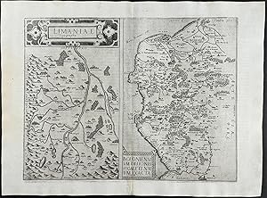
Regional Maps of France (Limaniae topographia & Boloniensium Ditionis)
Edité par Antwerp, 1593
Vendeur : Trillium Antique Prints & Rare Books, Franklin, TN, Etats-Unis
Evaluation du vendeur :
Art / Affiche / Gravure
Etat : Fine. This truly significant map is from one of the rarest atlases ever published, Gerard and Cornelis de Jode's Speculum orbis Terrae. The work was published in Antwerp in 1593 by Arnold Coninx for the widow and heirs. This is considered the second edition, revised an expanded. The first edition was published in 1578. Van Ortroy knew of only 14 copies of the second edition being published. (Skelton, Introduction to the facsimile editions)De Jode drew upon his large stock of maps from Italian, German, and Flemish cartographers to create his atlas. He engraved some of the maps and his brothers, Joannes and Lucas van Deutecum, also contributed to the process. The second edition included additional maps from Gerard's son Cornelis. The maps have descriptive text to verso in Latin. The text for the first edition was written by the German scholar, Daniel Cellarius.The atlas contained some of the most groundbreaking maps ever published. The maps of the world, Americas, Australia, and China are of particular note and remain some of the most important maps ever published. While it may not have had commercial success at the time, it is considered a masterpiece of 16th century cartography. Very few examples of the maps have survived from either edition.Gerard de Jode (1521- 1591) was a Flemish cartographer, printer, and engraver. He produced and sold many maps in Antwerp, but his legacy lies in his outstanding atlas, Speculum Orbis Terrarum. De Jode was a contemporary and competitor of Abraham Ortelius. Ortelius was believed to have been responsible for delaying de Jode's work so his atlas Theatrum Orbis Terrarum would precede de Jode's. Because Ortelius's atlas had 8 years on the market it was well established and thus de Jode's atlas did not sell very well.To compete with Ortelius, de Jode worked on the second revised and expanded edition. De Jode's wife and son, Cornelis (1568-1600) took over the publishing upon Gerard's death in 1591. Cornelis prepared ten new maps of the World, North America, China, Australia and Alaska and re-issued the atlas. "Many of de Jodeâ s maps are judged to be superior to those of Ortelius, both in detail and style." (Burden)Antwerp publisher Joan Baptista Vrients purchased the plates after Cornelis's death. He also acquired Ortelius's plates for Theatrum Orbis Terrarum to which he gave priority. It is likely he bought de Jode's plates to prevent any further editions of Speculum of course only increasing the intrigue and worth of the maps today."Although the atlas may not have appealed to the public, it was admired by other cartographers. As evidence, Petrus Montanus mentions it in the same breath with Mercatorâ s Atlas and Orteliusâ Theatrum in his preface to Pieter Kaeriusâ Germaniae inferior (Wardington Catalogue), Michael von Aitzing refers to it in his work, DeLeone Belgico (1583). Von Aitzing intended his work to act also as a supplement to both the Theatrum of Ortelius and the Speculum of De Jode." (Burden)Provenance : Ownership inscription at the bottom of the title page ex Bibliotheca Prim d Federici 1600.References: Van der Krogt 32:02B (titles 32:2A and 32:2B) ; Koeman II, Jod 2 ; Shirley, The mapping of the world, 165,184 ; Burden, The mapping of America, 81, 82 ; Symour, L. Schwartz, Ehrenberg, The mapping of America, pp. 78-79 ; Norwich, Maps of Africa 19 ; Navari, Maps of Cyprus, 29 ; Tooley, Dictionnary of mapmakers II, p. 441 ; Tooley, Mapping of Australia,; Tooley, Arabia in early maps, 38 (1st ed.) ; Koeman, Schilder, van Egmond, van der Krogt, HOC,vol. 3 part 2, Commercial Cartography and Map Production in the Low Countries, 1500 â " ca. 1672, pp. 1321-1323 ; Ortroy, Fern van, Lâ oeuvre cartographique de Gerard et de Corneille de Jode, Gand 1914, 82-121. --- The work is in very good to excellent condition overall. The maps from this work are truly in remarkable condition for the age. While some faint offset or minor marks or imperfections can be expected, they generally.
-

Map of Bayern, Germany (Bavariae Utriusque cum Inferioris tu Superioris Vera et ad Amus Sim Descriptio)
Edité par Antwerp, 1593
Vendeur : Trillium Antique Prints & Rare Books, Franklin, TN, Etats-Unis
Evaluation du vendeur :
Art / Affiche / Gravure
Etat : Fine. This truly significant map is from one of the rarest atlases ever published, Gerard and Cornelis de Jode's Speculum orbis Terrae. The work was published in Antwerp in 1593 by Arnold Coninx for the widow and heirs. This is considered the second edition, revised an expanded. The first edition was published in 1578. Van Ortroy knew of only 14 copies of the second edition being published. (Skelton, Introduction to the facsimile editions)De Jode drew upon his large stock of maps from Italian, German, and Flemish cartographers to create his atlas. He engraved some of the maps and his brothers, Joannes and Lucas van Deutecum, also contributed to the process. The second edition included additional maps from Gerard's son Cornelis. The maps have descriptive text to verso in Latin. The text for the first edition was written by the German scholar, Daniel Cellarius.The atlas contained some of the most groundbreaking maps ever published. The maps of the world, Americas, Australia, and China are of particular note and remain some of the most important maps ever published. While it may not have had commercial success at the time, it is considered a masterpiece of 16th century cartography. Very few examples of the maps have survived from either edition.Gerard de Jode (1521- 1591) was a Flemish cartographer, printer, and engraver. He produced and sold many maps in Antwerp, but his legacy lies in his outstanding atlas, Speculum Orbis Terrarum. De Jode was a contemporary and competitor of Abraham Ortelius. Ortelius was believed to have been responsible for delaying de Jode's work so his atlas Theatrum Orbis Terrarum would precede de Jode's. Because Ortelius's atlas had 8 years on the market it was well established and thus de Jode's atlas did not sell very well.To compete with Ortelius, de Jode worked on the second revised and expanded edition. De Jode's wife and son, Cornelis (1568-1600) took over the publishing upon Gerard's death in 1591. Cornelis prepared ten new maps of the World, North America, China, Australia and Alaska and re-issued the atlas. "Many of de Jodeâ s maps are judged to be superior to those of Ortelius, both in detail and style." (Burden)Antwerp publisher Joan Baptista Vrients purchased the plates after Cornelis's death. He also acquired Ortelius's plates for Theatrum Orbis Terrarum to which he gave priority. It is likely he bought de Jode's plates to prevent any further editions of Speculum of course only increasing the intrigue and worth of the maps today."Although the atlas may not have appealed to the public, it was admired by other cartographers. As evidence, Petrus Montanus mentions it in the same breath with Mercatorâ s Atlas and Orteliusâ Theatrum in his preface to Pieter Kaeriusâ Germaniae inferior (Wardington Catalogue), Michael von Aitzing refers to it in his work, DeLeone Belgico (1583). Von Aitzing intended his work to act also as a supplement to both the Theatrum of Ortelius and the Speculum of De Jode." (Burden)Provenance : Ownership inscription at the bottom of the title page ex Bibliotheca Prim d Federici 1600.References: Van der Krogt 32:02B (titles 32:2A and 32:2B) ; Koeman II, Jod 2 ; Shirley, The mapping of the world, 165,184 ; Burden, The mapping of America, 81, 82 ; Symour, L. Schwartz, Ehrenberg, The mapping of America, pp. 78-79 ; Norwich, Maps of Africa 19 ; Navari, Maps of Cyprus, 29 ; Tooley, Dictionnary of mapmakers II, p. 441 ; Tooley, Mapping of Australia,; Tooley, Arabia in early maps, 38 (1st ed.) ; Koeman, Schilder, van Egmond, van der Krogt, HOC,vol. 3 part 2, Commercial Cartography and Map Production in the Low Countries, 1500 â " ca. 1672, pp. 1321-1323 ; Ortroy, Fern van, Lâ oeuvre cartographique de Gerard et de Corneille de Jode, Gand 1914, 82-121. --- The work is in very good to excellent condition overall. The maps from this work are truly in remarkable condition for the age. While some faint offset or minor marks or imperfections can be expected, they generally.
-

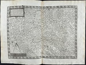
Map of Lorraine, France (Lotharingia Ducatus)
Edité par Antwerp, 1593
Vendeur : Trillium Antique Prints & Rare Books, Franklin, TN, Etats-Unis
Evaluation du vendeur :
Art / Affiche / Gravure
Etat : Fine. This truly significant map is from one of the rarest atlases ever published, Gerard and Cornelis de Jode's Speculum orbis Terrae. The work was published in Antwerp in 1593 by Arnold Coninx for the widow and heirs. This is considered the second edition, revised an expanded. The first edition was published in 1578. Van Ortroy knew of only 14 copies of the second edition being published. (Skelton, Introduction to the facsimile editions)De Jode drew upon his large stock of maps from Italian, German, and Flemish cartographers to create his atlas. He engraved some of the maps and his brothers, Joannes and Lucas van Deutecum, also contributed to the process. The second edition included additional maps from Gerard's son Cornelis. The maps have descriptive text to verso in Latin. The text for the first edition was written by the German scholar, Daniel Cellarius.The atlas contained some of the most groundbreaking maps ever published. The maps of the world, Americas, Australia, and China are of particular note and remain some of the most important maps ever published. While it may not have had commercial success at the time, it is considered a masterpiece of 16th century cartography. Very few examples of the maps have survived from either edition.Gerard de Jode (1521- 1591) was a Flemish cartographer, printer, and engraver. He produced and sold many maps in Antwerp, but his legacy lies in his outstanding atlas, Speculum Orbis Terrarum. De Jode was a contemporary and competitor of Abraham Ortelius. Ortelius was believed to have been responsible for delaying de Jode's work so his atlas Theatrum Orbis Terrarum would precede de Jode's. Because Ortelius's atlas had 8 years on the market it was well established and thus de Jode's atlas did not sell very well.To compete with Ortelius, de Jode worked on the second revised and expanded edition. De Jode's wife and son, Cornelis (1568-1600) took over the publishing upon Gerard's death in 1591. Cornelis prepared ten new maps of the World, North America, China, Australia and Alaska and re-issued the atlas. "Many of de Jodeâ s maps are judged to be superior to those of Ortelius, both in detail and style." (Burden)Antwerp publisher Joan Baptista Vrients purchased the plates after Cornelis's death. He also acquired Ortelius's plates for Theatrum Orbis Terrarum to which he gave priority. It is likely he bought de Jode's plates to prevent any further editions of Speculum of course only increasing the intrigue and worth of the maps today."Although the atlas may not have appealed to the public, it was admired by other cartographers. As evidence, Petrus Montanus mentions it in the same breath with Mercatorâ s Atlas and Orteliusâ Theatrum in his preface to Pieter Kaeriusâ Germaniae inferior (Wardington Catalogue), Michael von Aitzing refers to it in his work, DeLeone Belgico (1583). Von Aitzing intended his work to act also as a supplement to both the Theatrum of Ortelius and the Speculum of De Jode." (Burden)Provenance : Ownership inscription at the bottom of the title page ex Bibliotheca Prim d Federici 1600.References: Van der Krogt 32:02B (titles 32:2A and 32:2B) ; Koeman II, Jod 2 ; Shirley, The mapping of the world, 165,184 ; Burden, The mapping of America, 81, 82 ; Symour, L. Schwartz, Ehrenberg, The mapping of America, pp. 78-79 ; Norwich, Maps of Africa 19 ; Navari, Maps of Cyprus, 29 ; Tooley, Dictionnary of mapmakers II, p. 441 ; Tooley, Mapping of Australia,; Tooley, Arabia in early maps, 38 (1st ed.) ; Koeman, Schilder, van Egmond, van der Krogt, HOC,vol. 3 part 2, Commercial Cartography and Map Production in the Low Countries, 1500 â " ca. 1672, pp. 1321-1323 ; Ortroy, Fern van, Lâ oeuvre cartographique de Gerard et de Corneille de Jode, Gand 1914, 82-121. --- The work is in very good to excellent condition overall. The maps from this work are truly in remarkable condition for the age. While some faint offset or minor marks or imperfections can be expected, they generally.
-

Frontispiece or Title Page with Map of Germany, Poland and the Low Countries
Edité par Antwerp, 1593
Vendeur : Trillium Antique Prints & Rare Books, Franklin, TN, Etats-Unis
Evaluation du vendeur :
Art / Affiche / Gravure
Etat : Fine. This truly significant map is from one of the rarest atlases ever published, Gerard and Cornelis de Jode's Speculum orbis Terrae. The work was published in Antwerp in 1593 by Arnold Coninx for the widow and heirs. This is considered the second edition, revised an expanded. The first edition was published in 1578. Van Ortroy knew of only 14 copies of the second edition being published. (Skelton, Introduction to the facsimile editions)De Jode drew upon his large stock of maps from Italian, German, and Flemish cartographers to create his atlas. He engraved some of the maps and his brothers, Joannes and Lucas van Deutecum, also contributed to the process. The second edition included additional maps from Gerard's son Cornelis. The maps have descriptive text to verso in Latin. The text for the first edition was written by the German scholar, Daniel Cellarius.The atlas contained some of the most groundbreaking maps ever published. The maps of the world, Americas, Australia, and China are of particular note and remain some of the most important maps ever published. While it may not have had commercial success at the time, it is considered a masterpiece of 16th century cartography. Very few examples of the maps have survived from either edition.Gerard de Jode (1521- 1591) was a Flemish cartographer, printer, and engraver. He produced and sold many maps in Antwerp, but his legacy lies in his outstanding atlas, Speculum Orbis Terrarum. De Jode was a contemporary and competitor of Abraham Ortelius. Ortelius was believed to have been responsible for delaying de Jode's work so his atlas Theatrum Orbis Terrarum would precede de Jode's. Because Ortelius's atlas had 8 years on the market it was well established and thus de Jode's atlas did not sell very well.To compete with Ortelius, de Jode worked on the second revised and expanded edition. De Jode's wife and son, Cornelis (1568-1600) took over the publishing upon Gerard's death in 1591. Cornelis prepared ten new maps of the World, North America, China, Australia and Alaska and re-issued the atlas. "Many of de Jodeâ s maps are judged to be superior to those of Ortelius, both in detail and style." (Burden)Antwerp publisher Joan Baptista Vrients purchased the plates after Cornelis's death. He also acquired Ortelius's plates for Theatrum Orbis Terrarum to which he gave priority. It is likely he bought de Jode's plates to prevent any further editions of Speculum of course only increasing the intrigue and worth of the maps today."Although the atlas may not have appealed to the public, it was admired by other cartographers. As evidence, Petrus Montanus mentions it in the same breath with Mercatorâ s Atlas and Orteliusâ Theatrum in his preface to Pieter Kaeriusâ Germaniae inferior (Wardington Catalogue), Michael von Aitzing refers to it in his work, DeLeone Belgico (1583). Von Aitzing intended his work to act also as a supplement to both the Theatrum of Ortelius and the Speculum of De Jode." (Burden)Provenance : Ownership inscription at the bottom of the title page ex Bibliotheca Prim d Federici 1600.References: Van der Krogt 32:02B (titles 32:2A and 32:2B) ; Koeman II, Jod 2 ; Shirley, The mapping of the world, 165,184 ; Burden, The mapping of America, 81, 82 ; Symour, L. Schwartz, Ehrenberg, The mapping of America, pp. 78-79 ; Norwich, Maps of Africa 19 ; Navari, Maps of Cyprus, 29 ; Tooley, Dictionnary of mapmakers II, p. 441 ; Tooley, Mapping of Australia,; Tooley, Arabia in early maps, 38 (1st ed.) ; Koeman, Schilder, van Egmond, van der Krogt, HOC,vol. 3 part 2, Commercial Cartography and Map Production in the Low Countries, 1500 â " ca. 1672, pp. 1321-1323 ; Ortroy, Fern van, Lâ oeuvre cartographique de Gerard et de Corneille de Jode, Gand 1914, 82-121. --- The work is in very good to excellent condition overall. The maps from this work are truly in remarkable condition for the age. While some faint offset or minor marks or imperfections can be expected, they generally.
-
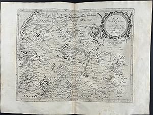
Map of Rheinland-Pfalz, Germany (Palatinatus Rheni, & circuiacentes Regionesâ ¦)
Edité par Antwerp, 1593
Vendeur : Trillium Antique Prints & Rare Books, Franklin, TN, Etats-Unis
Evaluation du vendeur :
Art / Affiche / Gravure
Etat : Fine. This truly significant map is from one of the rarest atlases ever published, Gerard and Cornelis de Jode's Speculum orbis Terrae. The work was published in Antwerp in 1593 by Arnold Coninx for the widow and heirs. This is considered the second edition, revised an expanded. The first edition was published in 1578. Van Ortroy knew of only 14 copies of the second edition being published. (Skelton, Introduction to the facsimile editions)De Jode drew upon his large stock of maps from Italian, German, and Flemish cartographers to create his atlas. He engraved some of the maps and his brothers, Joannes and Lucas van Deutecum, also contributed to the process. The second edition included additional maps from Gerard's son Cornelis. The maps have descriptive text to verso in Latin. The text for the first edition was written by the German scholar, Daniel Cellarius.The atlas contained some of the most groundbreaking maps ever published. The maps of the world, Americas, Australia, and China are of particular note and remain some of the most important maps ever published. While it may not have had commercial success at the time, it is considered a masterpiece of 16th century cartography. Very few examples of the maps have survived from either edition.Gerard de Jode (1521- 1591) was a Flemish cartographer, printer, and engraver. He produced and sold many maps in Antwerp, but his legacy lies in his outstanding atlas, Speculum Orbis Terrarum. De Jode was a contemporary and competitor of Abraham Ortelius. Ortelius was believed to have been responsible for delaying de Jode's work so his atlas Theatrum Orbis Terrarum would precede de Jode's. Because Ortelius's atlas had 8 years on the market it was well established and thus de Jode's atlas did not sell very well.To compete with Ortelius, de Jode worked on the second revised and expanded edition. De Jode's wife and son, Cornelis (1568-1600) took over the publishing upon Gerard's death in 1591. Cornelis prepared ten new maps of the World, North America, China, Australia and Alaska and re-issued the atlas. "Many of de Jodeâ s maps are judged to be superior to those of Ortelius, both in detail and style." (Burden)Antwerp publisher Joan Baptista Vrients purchased the plates after Cornelis's death. He also acquired Ortelius's plates for Theatrum Orbis Terrarum to which he gave priority. It is likely he bought de Jode's plates to prevent any further editions of Speculum of course only increasing the intrigue and worth of the maps today."Although the atlas may not have appealed to the public, it was admired by other cartographers. As evidence, Petrus Montanus mentions it in the same breath with Mercatorâ s Atlas and Orteliusâ Theatrum in his preface to Pieter Kaeriusâ Germaniae inferior (Wardington Catalogue), Michael von Aitzing refers to it in his work, DeLeone Belgico (1583). Von Aitzing intended his work to act also as a supplement to both the Theatrum of Ortelius and the Speculum of De Jode." (Burden)Provenance : Ownership inscription at the bottom of the title page ex Bibliotheca Prim d Federici 1600.References: Van der Krogt 32:02B (titles 32:2A and 32:2B) ; Koeman II, Jod 2 ; Shirley, The mapping of the world, 165,184 ; Burden, The mapping of America, 81, 82 ; Symour, L. Schwartz, Ehrenberg, The mapping of America, pp. 78-79 ; Norwich, Maps of Africa 19 ; Navari, Maps of Cyprus, 29 ; Tooley, Dictionnary of mapmakers II, p. 441 ; Tooley, Mapping of Australia,; Tooley, Arabia in early maps, 38 (1st ed.) ; Koeman, Schilder, van Egmond, van der Krogt, HOC,vol. 3 part 2, Commercial Cartography and Map Production in the Low Countries, 1500 â " ca. 1672, pp. 1321-1323 ; Ortroy, Fern van, Lâ oeuvre cartographique de Gerard et de Corneille de Jode, Gand 1914, 82-121. --- The work is in very good to excellent condition overall. The maps from this work are truly in remarkable condition for the age. While some faint offset or minor marks or imperfections can be expected, they generally.
-
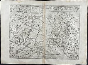
Maps of Vermandois, France & Duchy of Savoy (Typus Corographicus Veromanduae partis Galliae Belgicae & Sabaudiae Ducatus, Sue Narbonensi Galliae Partis, Vera Germanaque Delineatio)
Edité par Antwerp, 1593
Vendeur : Trillium Antique Prints & Rare Books, Franklin, TN, Etats-Unis
Evaluation du vendeur :
Art / Affiche / Gravure
Etat : Fine. This truly significant map is from one of the rarest atlases ever published, Gerard and Cornelis de Jode's Speculum orbis Terrae. The work was published in Antwerp in 1593 by Arnold Coninx for the widow and heirs. This is considered the second edition, revised an expanded. The first edition was published in 1578. Van Ortroy knew of only 14 copies of the second edition being published. (Skelton, Introduction to the facsimile editions)De Jode drew upon his large stock of maps from Italian, German, and Flemish cartographers to create his atlas. He engraved some of the maps and his brothers, Joannes and Lucas van Deutecum, also contributed to the process. The second edition included additional maps from Gerard's son Cornelis. The maps have descriptive text to verso in Latin. The text for the first edition was written by the German scholar, Daniel Cellarius.The atlas contained some of the most groundbreaking maps ever published. The maps of the world, Americas, Australia, and China are of particular note and remain some of the most important maps ever published. While it may not have had commercial success at the time, it is considered a masterpiece of 16th century cartography. Very few examples of the maps have survived from either edition.Gerard de Jode (1521- 1591) was a Flemish cartographer, printer, and engraver. He produced and sold many maps in Antwerp, but his legacy lies in his outstanding atlas, Speculum Orbis Terrarum. De Jode was a contemporary and competitor of Abraham Ortelius. Ortelius was believed to have been responsible for delaying de Jode's work so his atlas Theatrum Orbis Terrarum would precede de Jode's. Because Ortelius's atlas had 8 years on the market it was well established and thus de Jode's atlas did not sell very well.To compete with Ortelius, de Jode worked on the second revised and expanded edition. De Jode's wife and son, Cornelis (1568-1600) took over the publishing upon Gerard's death in 1591. Cornelis prepared ten new maps of the World, North America, China, Australia and Alaska and re-issued the atlas. "Many of de Jodeâ s maps are judged to be superior to those of Ortelius, both in detail and style." (Burden)Antwerp publisher Joan Baptista Vrients purchased the plates after Cornelis's death. He also acquired Ortelius's plates for Theatrum Orbis Terrarum to which he gave priority. It is likely he bought de Jode's plates to prevent any further editions of Speculum of course only increasing the intrigue and worth of the maps today."Although the atlas may not have appealed to the public, it was admired by other cartographers. As evidence, Petrus Montanus mentions it in the same breath with Mercatorâ s Atlas and Orteliusâ Theatrum in his preface to Pieter Kaeriusâ Germaniae inferior (Wardington Catalogue), Michael von Aitzing refers to it in his work, DeLeone Belgico (1583). Von Aitzing intended his work to act also as a supplement to both the Theatrum of Ortelius and the Speculum of De Jode." (Burden)Provenance : Ownership inscription at the bottom of the title page ex Bibliotheca Prim d Federici 1600.References: Van der Krogt 32:02B (titles 32:2A and 32:2B) ; Koeman II, Jod 2 ; Shirley, The mapping of the world, 165,184 ; Burden, The mapping of America, 81, 82 ; Symour, L. Schwartz, Ehrenberg, The mapping of America, pp. 78-79 ; Norwich, Maps of Africa 19 ; Navari, Maps of Cyprus, 29 ; Tooley, Dictionnary of mapmakers II, p. 441 ; Tooley, Mapping of Australia,; Tooley, Arabia in early maps, 38 (1st ed.) ; Koeman, Schilder, van Egmond, van der Krogt, HOC,vol. 3 part 2, Commercial Cartography and Map Production in the Low Countries, 1500 â " ca. 1672, pp. 1321-1323 ; Ortroy, Fern van, Lâ oeuvre cartographique de Gerard et de Corneille de Jode, Gand 1914, 82-121. --- The work is in very good to excellent condition overall. The maps from this work are truly in remarkable condition for the age. While some faint offset or minor marks or imperfections can be expected, they generally.
-
Map of part of Germany
Edité par Antwerp, 1593
Vendeur : Trillium Antique Prints & Rare Books, Franklin, TN, Etats-Unis
Evaluation du vendeur :
Art / Affiche / Gravure
Etat : Fine. This truly significant map is from one of the rarest atlases ever published, Gerard and Cornelis de Jode's Speculum orbis Terrae. The work was published in Antwerp in 1593 by Arnold Coninx for the widow and heirs. This is considered the second edition, revised an expanded. The first edition was published in 1578. Van Ortroy knew of only 14 copies of the second edition being published. (Skelton, Introduction to the facsimile editions)De Jode drew upon his large stock of maps from Italian, German, and Flemish cartographers to create his atlas. He engraved some of the maps and his brothers, Joannes and Lucas van Deutecum, also contributed to the process. The second edition included additional maps from Gerard's son Cornelis. The maps have descriptive text to verso in Latin. The text for the first edition was written by the German scholar, Daniel Cellarius.The atlas contained some of the most groundbreaking maps ever published. The maps of the world, Americas, Australia, and China are of particular note and remain some of the most important maps ever published. While it may not have had commercial success at the time, it is considered a masterpiece of 16th century cartography. Very few examples of the maps have survived from either edition.Gerard de Jode (1521- 1591) was a Flemish cartographer, printer, and engraver. He produced and sold many maps in Antwerp, but his legacy lies in his outstanding atlas, Speculum Orbis Terrarum. De Jode was a contemporary and competitor of Abraham Ortelius. Ortelius was believed to have been responsible for delaying de Jode's work so his atlas Theatrum Orbis Terrarum would precede de Jode's. Because Ortelius's atlas had 8 years on the market it was well established and thus de Jode's atlas did not sell very well.To compete with Ortelius, de Jode worked on the second revised and expanded edition. De Jode's wife and son, Cornelis (1568-1600) took over the publishing upon Gerard's death in 1591. Cornelis prepared ten new maps of the World, North America, China, Australia and Alaska and re-issued the atlas. "Many of de Jodeâ s maps are judged to be superior to those of Ortelius, both in detail and style." (Burden)Antwerp publisher Joan Baptista Vrients purchased the plates after Cornelis's death. He also acquired Ortelius's plates for Theatrum Orbis Terrarum to which he gave priority. It is likely he bought de Jode's plates to prevent any further editions of Speculum of course only increasing the intrigue and worth of the maps today."Although the atlas may not have appealed to the public, it was admired by other cartographers. As evidence, Petrus Montanus mentions it in the same breath with Mercatorâ s Atlas and Orteliusâ Theatrum in his preface to Pieter Kaeriusâ Germaniae inferior (Wardington Catalogue), Michael von Aitzing refers to it in his work, DeLeone Belgico (1583). Von Aitzing intended his work to act also as a supplement to both the Theatrum of Ortelius and the Speculum of De Jode." (Burden)Provenance : Ownership inscription at the bottom of the title page ex Bibliotheca Prim d Federici 1600.References: Van der Krogt 32:02B (titles 32:2A and 32:2B) ; Koeman II, Jod 2 ; Shirley, The mapping of the world, 165,184 ; Burden, The mapping of America, 81, 82 ; Symour, L. Schwartz, Ehrenberg, The mapping of America, pp. 78-79 ; Norwich, Maps of Africa 19 ; Navari, Maps of Cyprus, 29 ; Tooley, Dictionnary of mapmakers II, p. 441 ; Tooley, Mapping of Australia,; Tooley, Arabia in early maps, 38 (1st ed.) ; Koeman, Schilder, van Egmond, van der Krogt, HOC,vol. 3 part 2, Commercial Cartography and Map Production in the Low Countries, 1500 â " ca. 1672, pp. 1321-1323 ; Ortroy, Fern van, Lâ oeuvre cartographique de Gerard et de Corneille de Jode, Gand 1914, 82-121. --- The work is in very good to excellent condition overall. The maps from this work are truly in remarkable condition for the age. While some faint offset or minor marks or imperfections can be expected, they generally.
-

German Emperors
Edité par Antwerp, 1593
Vendeur : Trillium Antique Prints & Rare Books, Franklin, TN, Etats-Unis
Evaluation du vendeur :
Art / Affiche / Gravure
Etat : Fine. This truly significant map is from one of the rarest atlases ever published, Gerard and Cornelis de Jode's Speculum orbis Terrae. The work was published in Antwerp in 1593 by Arnold Coninx for the widow and heirs. This is considered the second edition, revised an expanded. The first edition was published in 1578. Van Ortroy knew of only 14 copies of the second edition being published. (Skelton, Introduction to the facsimile editions)De Jode drew upon his large stock of maps from Italian, German, and Flemish cartographers to create his atlas. He engraved some of the maps and his brothers, Joannes and Lucas van Deutecum, also contributed to the process. The second edition included additional maps from Gerard's son Cornelis. The maps have descriptive text to verso in Latin. The text for the first edition was written by the German scholar, Daniel Cellarius.The atlas contained some of the most groundbreaking maps ever published. The maps of the world, Americas, Australia, and China are of particular note and remain some of the most important maps ever published. While it may not have had commercial success at the time, it is considered a masterpiece of 16th century cartography. Very few examples of the maps have survived from either edition.Gerard de Jode (1521- 1591) was a Flemish cartographer, printer, and engraver. He produced and sold many maps in Antwerp, but his legacy lies in his outstanding atlas, Speculum Orbis Terrarum. De Jode was a contemporary and competitor of Abraham Ortelius. Ortelius was believed to have been responsible for delaying de Jode's work so his atlas Theatrum Orbis Terrarum would precede de Jode's. Because Ortelius's atlas had 8 years on the market it was well established and thus de Jode's atlas did not sell very well.To compete with Ortelius, de Jode worked on the second revised and expanded edition. De Jode's wife and son, Cornelis (1568-1600) took over the publishing upon Gerard's death in 1591. Cornelis prepared ten new maps of the World, North America, China, Australia and Alaska and re-issued the atlas. "Many of de Jodeâ s maps are judged to be superior to those of Ortelius, both in detail and style." (Burden)Antwerp publisher Joan Baptista Vrients purchased the plates after Cornelis's death. He also acquired Ortelius's plates for Theatrum Orbis Terrarum to which he gave priority. It is likely he bought de Jode's plates to prevent any further editions of Speculum of course only increasing the intrigue and worth of the maps today."Although the atlas may not have appealed to the public, it was admired by other cartographers. As evidence, Petrus Montanus mentions it in the same breath with Mercatorâ s Atlas and Orteliusâ Theatrum in his preface to Pieter Kaeriusâ Germaniae inferior (Wardington Catalogue), Michael von Aitzing refers to it in his work, DeLeone Belgico (1583). Von Aitzing intended his work to act also as a supplement to both the Theatrum of Ortelius and the Speculum of De Jode." (Burden)Provenance : Ownership inscription at the bottom of the title page ex Bibliotheca Prim d Federici 1600.References: Van der Krogt 32:02B (titles 32:2A and 32:2B) ; Koeman II, Jod 2 ; Shirley, The mapping of the world, 165,184 ; Burden, The mapping of America, 81, 82 ; Symour, L. Schwartz, Ehrenberg, The mapping of America, pp. 78-79 ; Norwich, Maps of Africa 19 ; Navari, Maps of Cyprus, 29 ; Tooley, Dictionnary of mapmakers II, p. 441 ; Tooley, Mapping of Australia,; Tooley, Arabia in early maps, 38 (1st ed.) ; Koeman, Schilder, van Egmond, van der Krogt, HOC,vol. 3 part 2, Commercial Cartography and Map Production in the Low Countries, 1500 â " ca. 1672, pp. 1321-1323 ; Ortroy, Fern van, Lâ oeuvre cartographique de Gerard et de Corneille de Jode, Gand 1914, 82-121. --- The work is in very good to excellent condition overall. The maps from this work are truly in remarkable condition for the age. While some faint offset or minor marks or imperfections can be expected, they generally.
-
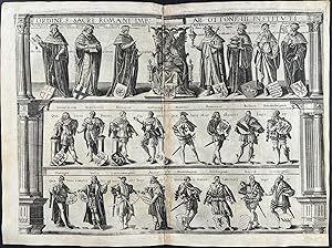
Electors of the Holy Roman Empire (Ordines Sacri Romani Imp: Ab Ottone III Instituti)
Edité par Antwerp, 1593
Vendeur : Trillium Antique Prints & Rare Books, Franklin, TN, Etats-Unis
Evaluation du vendeur :
Art / Affiche / Gravure
Etat : Fine. This truly significant map is from one of the rarest atlases ever published, Gerard and Cornelis de Jode's Speculum orbis Terrae. The work was published in Antwerp in 1593 by Arnold Coninx for the widow and heirs. This is considered the second edition, revised an expanded. The first edition was published in 1578. Van Ortroy knew of only 14 copies of the second edition being published. (Skelton, Introduction to the facsimile editions)De Jode drew upon his large stock of maps from Italian, German, and Flemish cartographers to create his atlas. He engraved some of the maps and his brothers, Joannes and Lucas van Deutecum, also contributed to the process. The second edition included additional maps from Gerard's son Cornelis. The maps have descriptive text to verso in Latin. The text for the first edition was written by the German scholar, Daniel Cellarius.The atlas contained some of the most groundbreaking maps ever published. The maps of the world, Americas, Australia, and China are of particular note and remain some of the most important maps ever published. While it may not have had commercial success at the time, it is considered a masterpiece of 16th century cartography. Very few examples of the maps have survived from either edition.Gerard de Jode (1521- 1591) was a Flemish cartographer, printer, and engraver. He produced and sold many maps in Antwerp, but his legacy lies in his outstanding atlas, Speculum Orbis Terrarum. De Jode was a contemporary and competitor of Abraham Ortelius. Ortelius was believed to have been responsible for delaying de Jode's work so his atlas Theatrum Orbis Terrarum would precede de Jode's. Because Ortelius's atlas had 8 years on the market it was well established and thus de Jode's atlas did not sell very well.To compete with Ortelius, de Jode worked on the second revised and expanded edition. De Jode's wife and son, Cornelis (1568-1600) took over the publishing upon Gerard's death in 1591. Cornelis prepared ten new maps of the World, North America, China, Australia and Alaska and re-issued the atlas. "Many of de Jodeâ s maps are judged to be superior to those of Ortelius, both in detail and style." (Burden)Antwerp publisher Joan Baptista Vrients purchased the plates after Cornelis's death. He also acquired Ortelius's plates for Theatrum Orbis Terrarum to which he gave priority. It is likely he bought de Jode's plates to prevent any further editions of Speculum of course only increasing the intrigue and worth of the maps today."Although the atlas may not have appealed to the public, it was admired by other cartographers. As evidence, Petrus Montanus mentions it in the same breath with Mercatorâ s Atlas and Orteliusâ Theatrum in his preface to Pieter Kaeriusâ Germaniae inferior (Wardington Catalogue), Michael von Aitzing refers to it in his work, DeLeone Belgico (1583). Von Aitzing intended his work to act also as a supplement to both the Theatrum of Ortelius and the Speculum of De Jode." (Burden)Provenance : Ownership inscription at the bottom of the title page ex Bibliotheca Prim d Federici 1600.References: Van der Krogt 32:02B (titles 32:2A and 32:2B) ; Koeman II, Jod 2 ; Shirley, The mapping of the world, 165,184 ; Burden, The mapping of America, 81, 82 ; Symour, L. Schwartz, Ehrenberg, The mapping of America, pp. 78-79 ; Norwich, Maps of Africa 19 ; Navari, Maps of Cyprus, 29 ; Tooley, Dictionnary of mapmakers II, p. 441 ; Tooley, Mapping of Australia,; Tooley, Arabia in early maps, 38 (1st ed.) ; Koeman, Schilder, van Egmond, van der Krogt, HOC,vol. 3 part 2, Commercial Cartography and Map Production in the Low Countries, 1500 â " ca. 1672, pp. 1321-1323 ; Ortroy, Fern van, Lâ oeuvre cartographique de Gerard et de Corneille de Jode, Gand 1914, 82-121. --- The work is in very good to excellent condition overall. The maps from this work are truly in remarkable condition for the age. While some faint offset or minor marks or imperfections can be expected, they generally.
-
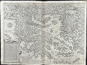
Map of Greece (Videbis Totius Greciae limites divisos per motes fluminaâ ¦)
Edité par Antwerp, 1593
Vendeur : Trillium Antique Prints & Rare Books, Franklin, TN, Etats-Unis
Evaluation du vendeur :
Art / Affiche / Gravure
Etat : Fine. This truly significant map is from one of the rarest atlases ever published, Gerard and Cornelis de Jode's Speculum orbis Terrae. The work was published in Antwerp in 1593 by Arnold Coninx for the widow and heirs. This is considered the second edition, revised an expanded. The first edition was published in 1578. Van Ortroy knew of only 14 copies of the second edition being published. (Skelton, Introduction to the facsimile editions)De Jode drew upon his large stock of maps from Italian, German, and Flemish cartographers to create his atlas. He engraved some of the maps and his brothers, Joannes and Lucas van Deutecum, also contributed to the process. The second edition included additional maps from Gerard's son Cornelis. The maps have descriptive text to verso in Latin. The text for the first edition was written by the German scholar, Daniel Cellarius.The atlas contained some of the most groundbreaking maps ever published. The maps of the world, Americas, Australia, and China are of particular note and remain some of the most important maps ever published. While it may not have had commercial success at the time, it is considered a masterpiece of 16th century cartography. Very few examples of the maps have survived from either edition.Gerard de Jode (1521- 1591) was a Flemish cartographer, printer, and engraver. He produced and sold many maps in Antwerp, but his legacy lies in his outstanding atlas, Speculum Orbis Terrarum. De Jode was a contemporary and competitor of Abraham Ortelius. Ortelius was believed to have been responsible for delaying de Jode's work so his atlas Theatrum Orbis Terrarum would precede de Jode's. Because Ortelius's atlas had 8 years on the market it was well established and thus de Jode's atlas did not sell very well.To compete with Ortelius, de Jode worked on the second revised and expanded edition. De Jode's wife and son, Cornelis (1568-1600) took over the publishing upon Gerard's death in 1591. Cornelis prepared ten new maps of the World, North America, China, Australia and Alaska and re-issued the atlas. "Many of de Jodeâ s maps are judged to be superior to those of Ortelius, both in detail and style." (Burden)Antwerp publisher Joan Baptista Vrients purchased the plates after Cornelis's death. He also acquired Ortelius's plates for Theatrum Orbis Terrarum to which he gave priority. It is likely he bought de Jode's plates to prevent any further editions of Speculum of course only increasing the intrigue and worth of the maps today."Although the atlas may not have appealed to the public, it was admired by other cartographers. As evidence, Petrus Montanus mentions it in the same breath with Mercatorâ s Atlas and Orteliusâ Theatrum in his preface to Pieter Kaeriusâ Germaniae inferior (Wardington Catalogue), Michael von Aitzing refers to it in his work, DeLeone Belgico (1583). Von Aitzing intended his work to act also as a supplement to both the Theatrum of Ortelius and the Speculum of De Jode." (Burden)Provenance : Ownership inscription at the bottom of the title page ex Bibliotheca Prim d Federici 1600.References: Van der Krogt 32:02B (titles 32:2A and 32:2B) ; Koeman II, Jod 2 ; Shirley, The mapping of the world, 165,184 ; Burden, The mapping of America, 81, 82 ; Symour, L. Schwartz, Ehrenberg, The mapping of America, pp. 78-79 ; Norwich, Maps of Africa 19 ; Navari, Maps of Cyprus, 29 ; Tooley, Dictionnary of mapmakers II, p. 441 ; Tooley, Mapping of Australia,; Tooley, Arabia in early maps, 38 (1st ed.) ; Koeman, Schilder, van Egmond, van der Krogt, HOC,vol. 3 part 2, Commercial Cartography and Map Production in the Low Countries, 1500 â " ca. 1672, pp. 1321-1323 ; Ortroy, Fern van, Lâ oeuvre cartographique de Gerard et de Corneille de Jode, Gand 1914, 82-121. --- The work is in very good to excellent condition overall. The maps from this work are truly in remarkable condition for the age. While some faint offset or minor marks or imperfections can be expected, they generally.
-
Map of Switzerland (Tractus Rhenanus multos olim Romanos labores peperit cuius initium occupant Helvetii olim Gallâ ¦)
Edité par Antwerp, 1593
Vendeur : Trillium Antique Prints & Rare Books, Franklin, TN, Etats-Unis
Evaluation du vendeur :
Art / Affiche / Gravure
Etat : Fine. This truly significant map is from one of the rarest atlases ever published, Gerard and Cornelis de Jode's Speculum orbis Terrae. The work was published in Antwerp in 1593 by Arnold Coninx for the widow and heirs. This is considered the second edition, revised an expanded. The first edition was published in 1578. Van Ortroy knew of only 14 copies of the second edition being published. (Skelton, Introduction to the facsimile editions)De Jode drew upon his large stock of maps from Italian, German, and Flemish cartographers to create his atlas. He engraved some of the maps and his brothers, Joannes and Lucas van Deutecum, also contributed to the process. The second edition included additional maps from Gerard's son Cornelis. The maps have descriptive text to verso in Latin. The text for the first edition was written by the German scholar, Daniel Cellarius.The atlas contained some of the most groundbreaking maps ever published. The maps of the world, Americas, Australia, and China are of particular note and remain some of the most important maps ever published. While it may not have had commercial success at the time, it is considered a masterpiece of 16th century cartography. Very few examples of the maps have survived from either edition.Gerard de Jode (1521- 1591) was a Flemish cartographer, printer, and engraver. He produced and sold many maps in Antwerp, but his legacy lies in his outstanding atlas, Speculum Orbis Terrarum. De Jode was a contemporary and competitor of Abraham Ortelius. Ortelius was believed to have been responsible for delaying de Jode's work so his atlas Theatrum Orbis Terrarum would precede de Jode's. Because Ortelius's atlas had 8 years on the market it was well established and thus de Jode's atlas did not sell very well.To compete with Ortelius, de Jode worked on the second revised and expanded edition. De Jode's wife and son, Cornelis (1568-1600) took over the publishing upon Gerard's death in 1591. Cornelis prepared ten new maps of the World, North America, China, Australia and Alaska and re-issued the atlas. "Many of de Jodeâ s maps are judged to be superior to those of Ortelius, both in detail and style." (Burden)Antwerp publisher Joan Baptista Vrients purchased the plates after Cornelis's death. He also acquired Ortelius's plates for Theatrum Orbis Terrarum to which he gave priority. It is likely he bought de Jode's plates to prevent any further editions of Speculum of course only increasing the intrigue and worth of the maps today."Although the atlas may not have appealed to the public, it was admired by other cartographers. As evidence, Petrus Montanus mentions it in the same breath with Mercatorâ s Atlas and Orteliusâ Theatrum in his preface to Pieter Kaeriusâ Germaniae inferior (Wardington Catalogue), Michael von Aitzing refers to it in his work, DeLeone Belgico (1583). Von Aitzing intended his work to act also as a supplement to both the Theatrum of Ortelius and the Speculum of De Jode." (Burden)Provenance : Ownership inscription at the bottom of the title page ex Bibliotheca Prim d Federici 1600.References: Van der Krogt 32:02B (titles 32:2A and 32:2B) ; Koeman II, Jod 2 ; Shirley, The mapping of the world, 165,184 ; Burden, The mapping of America, 81, 82 ; Symour, L. Schwartz, Ehrenberg, The mapping of America, pp. 78-79 ; Norwich, Maps of Africa 19 ; Navari, Maps of Cyprus, 29 ; Tooley, Dictionnary of mapmakers II, p. 441 ; Tooley, Mapping of Australia,; Tooley, Arabia in early maps, 38 (1st ed.) ; Koeman, Schilder, van Egmond, van der Krogt, HOC,vol. 3 part 2, Commercial Cartography and Map Production in the Low Countries, 1500 â " ca. 1672, pp. 1321-1323 ; Ortroy, Fern van, Lâ oeuvre cartographique de Gerard et de Corneille de Jode, Gand 1914, 82-121. --- The work is in very good to excellent condition overall. The maps from this work are truly in remarkable condition for the age. While some faint offset or minor marks or imperfections can be expected, they generally.
-
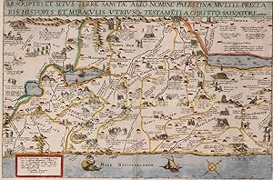
16TH CENTURY PICTORAL MAP OF THE HOLY LAND "Descriptio et Situs Terrae Sanctae alio Nomine Palestina, Multis Preclaris Historys et Miraculis utriusque testamenti a Christo Salvatore nobilitata
Vendeur : Inter-Antiquariaat Mefferdt & De Jonge, Amsterdam, Pays-Bas
Membre d'association : ILAB NVVA
Evaluation du vendeur :
Art / Affiche / Gravure
16TH CENTURY PICTORAL MAP OF THE HOLY LAND "Descriptio et Situs Terrae Sanctae alio Nomine Palestina, Multis Preclaris Historys et Miraculis utriusque testamenti a Christo Salvatore nobilitata." [The description and location of the Holy Land also called Palestine, famed for the many illustrious histories and miracles of both Testaments by Christ the Saviour.] Copper engraving published in 1593 by Gerard and Cornelis de Jode in the "Speculum Orbis Terrarum". Coloured by a later hand. Size: 33,9 x 51,4 cm. The map shows the Holy Land oriented to the east, with its coastline from Tyrus to Gaza. The events of the Bible are depicted in words and illustrations. It locates the Twelve Tribes, the descendants of the biblical patriarch Jacob, who collectively form the Israelite nation. Gerard de Jode states in the tekst box in the lower left: Here you find, good reader, a compendious description of the entire land of promise from the book of Joshua and Ezekiel, indicating the regions, cities, mountains, and monuments worthy of being known, both old and new. The De Jode family (Gerardus, the father, and Cornelis, the son) from Antwerp, had the misfortune of attempting to compete in the atlas market with the formidable and well-connected Abraham Ortelius. The De Jodes were and are respected as mapmakers, as evidenced by this work based on then current sources, but they were no commercial match for Ortelius. They published a mere two editions of their atlas as opposed to approximately 40 by Ortelius. Hence, the considerable rarity of De Jode maps in today s market. This map of the Holy land appeared in only the second edition of De Jode s atlas, and is consequently even rarer. Price: Euro 3.750,-.
-
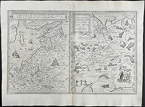
Maps of the Baltic, North Sea & Russia (Livoniae Provinciae Ac Eivs / Moscoviae Maximi Amplissimi Que Ducatus)
Edité par Antwerp, 1593
Vendeur : Trillium Antique Prints & Rare Books, Franklin, TN, Etats-Unis
Evaluation du vendeur :
Art / Affiche / Gravure
Etat : Fine. This truly significant map is from one of the rarest atlases ever published, Gerard and Cornelis de Jode's Speculum orbis Terrae. The work was published in Antwerp in 1593 by Arnold Coninx for the widow and heirs. This is considered the second edition, revised an expanded. The first edition was published in 1578. Van Ortroy knew of only 14 copies of the second edition being published. (Skelton, Introduction to the facsimile editions)De Jode drew upon his large stock of maps from Italian, German, and Flemish cartographers to create his atlas. He engraved some of the maps and his brothers, Joannes and Lucas van Deutecum, also contributed to the process. The second edition included additional maps from Gerard's son Cornelis. The maps have descriptive text to verso in Latin. The text for the first edition was written by the German scholar, Daniel Cellarius.The atlas contained some of the most groundbreaking maps ever published. The maps of the world, Americas, Australia, and China are of particular note and remain some of the most important maps ever published. While it may not have had commercial success at the time, it is considered a masterpiece of 16th century cartography. Very few examples of the maps have survived from either edition.Gerard de Jode (1521- 1591) was a Flemish cartographer, printer, and engraver. He produced and sold many maps in Antwerp, but his legacy lies in his outstanding atlas, Speculum Orbis Terrarum. De Jode was a contemporary and competitor of Abraham Ortelius. Ortelius was believed to have been responsible for delaying de Jode's work so his atlas Theatrum Orbis Terrarum would precede de Jode's. Because Ortelius's atlas had 8 years on the market it was well established and thus de Jode's atlas did not sell very well.To compete with Ortelius, de Jode worked on the second revised and expanded edition. De Jode's wife and son, Cornelis (1568-1600) took over the publishing upon Gerard's death in 1591. Cornelis prepared ten new maps of the World, North America, China, Australia and Alaska and re-issued the atlas. "Many of de Jodeâ s maps are judged to be superior to those of Ortelius, both in detail and style." (Burden)Antwerp publisher Joan Baptista Vrients purchased the plates after Cornelis's death. He also acquired Ortelius's plates for Theatrum Orbis Terrarum to which he gave priority. It is likely he bought de Jode's plates to prevent any further editions of Speculum of course only increasing the intrigue and worth of the maps today."Although the atlas may not have appealed to the public, it was admired by other cartographers. As evidence, Petrus Montanus mentions it in the same breath with Mercatorâ s Atlas and Orteliusâ Theatrum in his preface to Pieter Kaeriusâ Germaniae inferior (Wardington Catalogue), Michael von Aitzing refers to it in his work, DeLeone Belgico (1583). Von Aitzing intended his work to act also as a supplement to both the Theatrum of Ortelius and the Speculum of De Jode." (Burden)Provenance : Ownership inscription at the bottom of the title page ex Bibliotheca Prim d Federici 1600.References: Van der Krogt 32:02B (titles 32:2A and 32:2B) ; Koeman II, Jod 2 ; Shirley, The mapping of the world, 165,184 ; Burden, The mapping of America, 81, 82 ; Symour, L. Schwartz, Ehrenberg, The mapping of America, pp. 78-79 ; Norwich, Maps of Africa 19 ; Navari, Maps of Cyprus, 29 ; Tooley, Dictionnary of mapmakers II, p. 441 ; Tooley, Mapping of Australia,; Tooley, Arabia in early maps, 38 (1st ed.) ; Koeman, Schilder, van Egmond, van der Krogt, HOC,vol. 3 part 2, Commercial Cartography and Map Production in the Low Countries, 1500 â " ca. 1672, pp. 1321-1323 ; Ortroy, Fern van, Lâ oeuvre cartographique de Gerard et de Corneille de Jode, Gand 1914, 82-121. --- The work is in very good to excellent condition overall. The maps from this work are truly in remarkable condition for the age. While some faint offset or minor marks or imperfections can be expected, they generally.
-
Map of Kingdom of Napoli, Italy (Neapolitani Regni exacta ac diligens delineatio Authore Pyrrho Ligorio)
Edité par Antwerp, 1593
Vendeur : Trillium Antique Prints & Rare Books, Franklin, TN, Etats-Unis
Evaluation du vendeur :
Art / Affiche / Gravure
Etat : Fine. This truly significant map is from one of the rarest atlases ever published, Gerard and Cornelis de Jode's Speculum orbis Terrae. The work was published in Antwerp in 1593 by Arnold Coninx for the widow and heirs. This is considered the second edition, revised an expanded. The first edition was published in 1578. Van Ortroy knew of only 14 copies of the second edition being published. (Skelton, Introduction to the facsimile editions)De Jode drew upon his large stock of maps from Italian, German, and Flemish cartographers to create his atlas. He engraved some of the maps and his brothers, Joannes and Lucas van Deutecum, also contributed to the process. The second edition included additional maps from Gerard's son Cornelis. The maps have descriptive text to verso in Latin. The text for the first edition was written by the German scholar, Daniel Cellarius.The atlas contained some of the most groundbreaking maps ever published. The maps of the world, Americas, Australia, and China are of particular note and remain some of the most important maps ever published. While it may not have had commercial success at the time, it is considered a masterpiece of 16th century cartography. Very few examples of the maps have survived from either edition.Gerard de Jode (1521- 1591) was a Flemish cartographer, printer, and engraver. He produced and sold many maps in Antwerp, but his legacy lies in his outstanding atlas, Speculum Orbis Terrarum. De Jode was a contemporary and competitor of Abraham Ortelius. Ortelius was believed to have been responsible for delaying de Jode's work so his atlas Theatrum Orbis Terrarum would precede de Jode's. Because Ortelius's atlas had 8 years on the market it was well established and thus de Jode's atlas did not sell very well.To compete with Ortelius, de Jode worked on the second revised and expanded edition. De Jode's wife and son, Cornelis (1568-1600) took over the publishing upon Gerard's death in 1591. Cornelis prepared ten new maps of the World, North America, China, Australia and Alaska and re-issued the atlas. "Many of de Jodeâ s maps are judged to be superior to those of Ortelius, both in detail and style." (Burden)Antwerp publisher Joan Baptista Vrients purchased the plates after Cornelis's death. He also acquired Ortelius's plates for Theatrum Orbis Terrarum to which he gave priority. It is likely he bought de Jode's plates to prevent any further editions of Speculum of course only increasing the intrigue and worth of the maps today."Although the atlas may not have appealed to the public, it was admired by other cartographers. As evidence, Petrus Montanus mentions it in the same breath with Mercatorâ s Atlas and Orteliusâ Theatrum in his preface to Pieter Kaeriusâ Germaniae inferior (Wardington Catalogue), Michael von Aitzing refers to it in his work, DeLeone Belgico (1583). Von Aitzing intended his work to act also as a supplement to both the Theatrum of Ortelius and the Speculum of De Jode." (Burden)Provenance : Ownership inscription at the bottom of the title page ex Bibliotheca Prim d Federici 1600.References: Van der Krogt 32:02B (titles 32:2A and 32:2B) ; Koeman II, Jod 2 ; Shirley, The mapping of the world, 165,184 ; Burden, The mapping of America, 81, 82 ; Symour, L. Schwartz, Ehrenberg, The mapping of America, pp. 78-79 ; Norwich, Maps of Africa 19 ; Navari, Maps of Cyprus, 29 ; Tooley, Dictionnary of mapmakers II, p. 441 ; Tooley, Mapping of Australia,; Tooley, Arabia in early maps, 38 (1st ed.) ; Koeman, Schilder, van Egmond, van der Krogt, HOC,vol. 3 part 2, Commercial Cartography and Map Production in the Low Countries, 1500 â " ca. 1672, pp. 1321-1323 ; Ortroy, Fern van, Lâ oeuvre cartographique de Gerard et de Corneille de Jode, Gand 1914, 82-121. --- The work is in very good to excellent condition overall. The maps from this work are truly in remarkable condition for the age. While some faint offset or minor marks or imperfections can be expected, they generally.
-

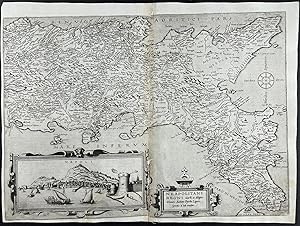
Map of Turkey, Greece, Cyprus, Armenia, and Asia Minor (Turcia Turci Cive Imperiiâ ¦ / Natoliam Moderni.)
Edité par Antwerp, 1593
Vendeur : Trillium Antique Prints & Rare Books, Franklin, TN, Etats-Unis
Evaluation du vendeur :
Art / Affiche / Gravure
Etat : Fine. This map of Turkey, Greece, Cyprus, Armenia, and Asia Minor is entitled Turcia Turci Cive Imperii seu Solij mannorum regni pleraque pars nunc recens Summa fide ac indusrai elucubrata | Natoliam Moderni dicunt tam partem quam Asiam minrem appelauere veteres. The map showed a long stretch of the Mediterranean and the Holy Land in great detail. It depicts Noah's Ark on Mount Ararat.Description of the work:This truly significant map is from one of the rarest atlases ever published, Gerard and Cornelis de Jode's Speculum orbis Terrae. The work was published in Antwerp in 1593 by Arnold Coninx for the widow and heirs. This is considered the second edition, revised an expanded. The first edition was published in 1578. Van Ortroy knew of only 14 copies of the second edition being published. (Skelton, Introduction to the facsimile editions)De Jode drew upon his large stock of maps from Italian, German, and Flemish cartographers to create his atlas. He engraved some of the maps and his brothers, Joannes and Lucas van Deutecum, also contributed to the process. The second edition included additional maps from Gerard's son Cornelis. The maps have descriptive text to verso in Latin. The text for the first edition was written by the German scholar, Daniel Cellarius.The atlas contained some of the most groundbreaking maps ever published. The maps of the world, Americas, Australia, and China are of particular note and remain some of the most important maps ever published. While it may not have had commercial success at the time, it is considered a masterpiece of 16th century cartography. Very few examples of the maps have survived from either edition.Gerard de Jode (1521- 1591) was a Flemish cartographer, printer, and engraver. He produced and sold many maps in Antwerp, but his legacy lies in his outstanding atlas, Speculum Orbis Terrarum. De Jode was a contemporary and competitor of Abraham Ortelius. Ortelius was believed to have been responsible for delaying de Jode's work so his atlas Theatrum Orbis Terrarum would precede de Jode's. Because Ortelius's atlas had 8 years on the market it was well established and thus de Jode's atlas did not sell very well.To compete with Ortelius, de Jode worked on the second revised and expanded edition. De Jode's wife and son, Cornelis (1568-1600) took over the publishing upon Gerard's death in 1591. Cornelis prepared ten new maps of the World, North America, China, Australia and Alaska and re-issued the atlas. "Many of de Jodeâ s maps are judged to be superior to those of Ortelius, both in detail and style." (Burden)Antwerp publisher Joan Baptista Vrients purchased the plates after Cornelis's death. He also acquired Ortelius's plates for Theatrum Orbis Terrarum to which he gave priority. It is likely he bought de Jode's plates to prevent any further editions of Speculum of course only increasing the intrigue and worth of the maps today."Although the atlas may not have appealed to the public, it was admired by other cartographers. As evidence, Petrus Montanus mentions it in the same breath with Mercatorâ s Atlas and Orteliusâ Theatrum in his preface to Pieter Kaeriusâ Germaniae inferior (Wardington Catalogue), Michael von Aitzing refers to it in his work, DeLeone Belgico (1583). Von Aitzing intended his work to act also as a supplement to both the Theatrum of Ortelius and the Speculum of De Jode." (Burden)Provenance : Ownership inscription at the bottom of the title page ex Bibliotheca Prim d Federici 1600.References: Van der Krogt 32:02B (titles 32:2A and 32:2B) ; Koeman II, Jod 2 ; Shirley, The mapping of the world, 165,184 ; Burden, The mapping of America, 81, 82 ; Symour, L. Schwartz, Ehrenberg, The mapping of America, pp. 78-79 ; Norwich, Maps of Africa 19 ; Navari, Maps of Cyprus, 29 ; Tooley, Dictionnary of mapmakers II, p. 441 ; Tooley, Mapping of Australia,; Tooley, Arabia in early maps, 38 (1st ed.) ; Koeman, Schilder, van Egmond, van der Krogt, HOC,vol. 3 part 2, Commercial Cart.
-
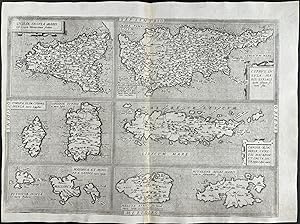
Map of Islands including Sicily, Corsica, Sardinia, Cyprus, Candia, Mallorca, Menorca, Malta, Mitilini
Edité par Antwerp, 1593
Vendeur : Trillium Antique Prints & Rare Books, Franklin, TN, Etats-Unis
Evaluation du vendeur :
Art / Affiche / Gravure
Etat : Fine. This truly significant map is from one of the rarest atlases ever published, Gerard and Cornelis de Jode's Speculum orbis Terrae. The work was published in Antwerp in 1593 by Arnold Coninx for the widow and heirs. This is considered the second edition, revised an expanded. The first edition was published in 1578. Van Ortroy knew of only 14 copies of the second edition being published. (Skelton, Introduction to the facsimile editions)De Jode drew upon his large stock of maps from Italian, German, and Flemish cartographers to create his atlas. He engraved some of the maps and his brothers, Joannes and Lucas van Deutecum, also contributed to the process. The second edition included additional maps from Gerard's son Cornelis. The maps have descriptive text to verso in Latin. The text for the first edition was written by the German scholar, Daniel Cellarius.The atlas contained some of the most groundbreaking maps ever published. The maps of the world, Americas, Australia, and China are of particular note and remain some of the most important maps ever published. While it may not have had commercial success at the time, it is considered a masterpiece of 16th century cartography. Very few examples of the maps have survived from either edition.Gerard de Jode (1521- 1591) was a Flemish cartographer, printer, and engraver. He produced and sold many maps in Antwerp, but his legacy lies in his outstanding atlas, Speculum Orbis Terrarum. De Jode was a contemporary and competitor of Abraham Ortelius. Ortelius was believed to have been responsible for delaying de Jode's work so his atlas Theatrum Orbis Terrarum would precede de Jode's. Because Ortelius's atlas had 8 years on the market it was well established and thus de Jode's atlas did not sell very well.To compete with Ortelius, de Jode worked on the second revised and expanded edition. De Jode's wife and son, Cornelis (1568-1600) took over the publishing upon Gerard's death in 1591. Cornelis prepared ten new maps of the World, North America, China, Australia and Alaska and re-issued the atlas. "Many of de Jodeâ s maps are judged to be superior to those of Ortelius, both in detail and style." (Burden)Antwerp publisher Joan Baptista Vrients purchased the plates after Cornelis's death. He also acquired Ortelius's plates for Theatrum Orbis Terrarum to which he gave priority. It is likely he bought de Jode's plates to prevent any further editions of Speculum of course only increasing the intrigue and worth of the maps today."Although the atlas may not have appealed to the public, it was admired by other cartographers. As evidence, Petrus Montanus mentions it in the same breath with Mercatorâ s Atlas and Orteliusâ Theatrum in his preface to Pieter Kaeriusâ Germaniae inferior (Wardington Catalogue), Michael von Aitzing refers to it in his work, DeLeone Belgico (1583). Von Aitzing intended his work to act also as a supplement to both the Theatrum of Ortelius and the Speculum of De Jode." (Burden)Provenance : Ownership inscription at the bottom of the title page ex Bibliotheca Prim d Federici 1600.References: Van der Krogt 32:02B (titles 32:2A and 32:2B) ; Koeman II, Jod 2 ; Shirley, The mapping of the world, 165,184 ; Burden, The mapping of America, 81, 82 ; Symour, L. Schwartz, Ehrenberg, The mapping of America, pp. 78-79 ; Norwich, Maps of Africa 19 ; Navari, Maps of Cyprus, 29 ; Tooley, Dictionnary of mapmakers II, p. 441 ; Tooley, Mapping of Australia,; Tooley, Arabia in early maps, 38 (1st ed.) ; Koeman, Schilder, van Egmond, van der Krogt, HOC,vol. 3 part 2, Commercial Cartography and Map Production in the Low Countries, 1500 â " ca. 1672, pp. 1321-1323 ; Ortroy, Fern van, Lâ oeuvre cartographique de Gerard et de Corneille de Jode, Gand 1914, 82-121. --- The work is in very good to excellent condition overall. The maps from this work are truly in remarkable condition for the age. While some faint offset or minor marks or imperfections can be expected, they generally.
-

Map of the Holy Land (Descriptio Et Situs Terrae Sanctae Alio Nomine Palestina Multis Preclaris Historys Et Miraculis Utriusque Testamenti A Christo Salvatore nobilitata)
Edité par Antwerp, 1593
Vendeur : Trillium Antique Prints & Rare Books, Franklin, TN, Etats-Unis
Evaluation du vendeur :
Art / Affiche / Gravure
Etat : Fine. This map of the Holy Land is entitled Descriptio Et Situs Terrae Sanctae Alio Nomine Palestina Multis Preclaris Historys Et Miraculis Utriusque Testamenti A Christo Salvatore nobilitata. The map is beautifully illustrated with stories from the Bible with notations of the book and verse.Description of the work:This truly significant map is from one of the rarest atlases ever published, Gerard and Cornelis de Jode's Speculum orbis Terrae. The work was published in Antwerp in 1593 by Arnold Coninx for the widow and heirs. This is considered the second edition, revised an expanded. The first edition was published in 1578. Van Ortroy knew of only 14 copies of the second edition being published. (Skelton, Introduction to the facsimile editions)De Jode drew upon his large stock of maps from Italian, German, and Flemish cartographers to create his atlas. He engraved some of the maps and his brothers, Joannes and Lucas van Deutecum, also contributed to the process. The second edition included additional maps from Gerard's son Cornelis. The maps have descriptive text to verso in Latin. The text for the first edition was written by the German scholar, Daniel Cellarius.The atlas contained some of the most groundbreaking maps ever published. The maps of the world, Americas, Australia, and China are of particular note and remain some of the most important maps ever published. While it may not have had commercial success at the time, it is considered a masterpiece of 16th century cartography. Very few examples of the maps have survived from either edition.Gerard de Jode (1521- 1591) was a Flemish cartographer, printer, and engraver. He produced and sold many maps in Antwerp, but his legacy lies in his outstanding atlas, Speculum Orbis Terrarum. De Jode was a contemporary and competitor of Abraham Ortelius. Ortelius was believed to have been responsible for delaying de Jode's work so his atlas Theatrum Orbis Terrarum would precede de Jode's. Because Ortelius's atlas had 8 years on the market it was well established and thus de Jode's atlas did not sell very well.To compete with Ortelius, de Jode worked on the second revised and expanded edition. De Jode's wife and son, Cornelis (1568-1600) took over the publishing upon Gerard's death in 1591. Cornelis prepared ten new maps of the World, North America, China, Australia and Alaska and re-issued the atlas. "Many of de Jodeâ s maps are judged to be superior to those of Ortelius, both in detail and style." (Burden)Antwerp publisher Joan Baptista Vrients purchased the plates after Cornelis's death. He also acquired Ortelius's plates for Theatrum Orbis Terrarum to which he gave priority. It is likely he bought de Jode's plates to prevent any further editions of Speculum of course only increasing the intrigue and worth of the maps today."Although the atlas may not have appealed to the public, it was admired by other cartographers. As evidence, Petrus Montanus mentions it in the same breath with Mercatorâ s Atlas and Orteliusâ Theatrum in his preface to Pieter Kaeriusâ Germaniae inferior (Wardington Catalogue), Michael von Aitzing refers to it in his work, DeLeone Belgico (1583). Von Aitzing intended his work to act also as a supplement to both the Theatrum of Ortelius and the Speculum of De Jode." (Burden)Provenance : Ownership inscription at the bottom of the title page ex Bibliotheca Prim d Federici 1600.References: Van der Krogt 32:02B (titles 32:2A and 32:2B) ; Koeman II, Jod 2 ; Shirley, The mapping of the world, 165,184 ; Burden, The mapping of America, 81, 82 ; Symour, L. Schwartz, Ehrenberg, The mapping of America, pp. 78-79 ; Norwich, Maps of Africa 19 ; Navari, Maps of Cyprus, 29 ; Tooley, Dictionnary of mapmakers II, p. 441 ; Tooley, Mapping of Australia,; Tooley, Arabia in early maps, 38 (1st ed.) ; Koeman, Schilder, van Egmond, van der Krogt, HOC,vol. 3 part 2, Commercial Cartography and Map Production in the Low Countries, 1500 â " ca. 1672, pp. 1321-1323 ; Ortroy, F.
-

Map of Asia (Tertiae Partis Asiae)
Edité par Antwerp, 1593
Vendeur : Trillium Antique Prints & Rare Books, Franklin, TN, Etats-Unis
Evaluation du vendeur :
Art / Affiche / Gravure
Etat : Fine. This map of eastern Asia is entitled Tertiae Partis Asiae quae modernis India orientalis dicitur acurata delineatio Autore Iacobo Castaldo Pedemontano. It was engraved by Gerard de Jode's brothers, Joannes and Lucas van Deutecum. The maps draws from Giacomo Gastaldi's work, Schilder notes it "had a major influence on the work of Ortelius and de Jode. In their representation of the coastlines his maps are superior to all previous known maps of Asia, either drawn by hand or printed." (Schilder in The Map Collector no. 17, p. 7)Description of the work:This truly significant map is from one of the rarest atlases ever published, Gerard and Cornelis de Jode's Speculum orbis Terrae. The work was published in Antwerp in 1593 by Arnold Coninx for the widow and heirs. This is considered the second edition, revised an expanded. The first edition was published in 1578. Van Ortroy knew of only 14 copies of the second edition being published. (Skelton, Introduction to the facsimile editions)De Jode drew upon his large stock of maps from Italian, German, and Flemish cartographers to create his atlas. He engraved some of the maps and his brothers, Joannes and Lucas van Deutecum, also contributed to the process. The second edition included additional maps from Gerard's son Cornelis. The maps have descriptive text to verso in Latin. The text for the first edition was written by the German scholar, Daniel Cellarius.The atlas contained some of the most groundbreaking maps ever published. The maps of the world, Americas, Australia, and China are of particular note and remain some of the most important maps ever published. While it may not have had commercial success at the time, it is considered a masterpiece of 16th century cartography. Very few examples of the maps have survived from either edition.Gerard de Jode (1521- 1591) was a Flemish cartographer, printer, and engraver. He produced and sold many maps in Antwerp, but his legacy lies in his outstanding atlas, Speculum Orbis Terrarum. De Jode was a contemporary and competitor of Abraham Ortelius. Ortelius was believed to have been responsible for delaying de Jode's work so his atlas Theatrum Orbis Terrarum would precede de Jode's. Because Ortelius's atlas had 8 years on the market it was well established and thus de Jode's atlas did not sell very well.To compete with Ortelius, de Jode worked on the second revised and expanded edition. De Jode's wife and son, Cornelis (1568-1600) took over the publishing upon Gerard's death in 1591. Cornelis prepared ten new maps of the World, North America, China, Australia and Alaska and re-issued the atlas. "Many of de Jodeâ s maps are judged to be superior to those of Ortelius, both in detail and style." (Burden)Antwerp publisher Joan Baptista Vrients purchased the plates after Cornelis's death. He also acquired Ortelius's plates for Theatrum Orbis Terrarum to which he gave priority. It is likely he bought de Jode's plates to prevent any further editions of Speculum of course only increasing the intrigue and worth of the maps today."Although the atlas may not have appealed to the public, it was admired by other cartographers. As evidence, Petrus Montanus mentions it in the same breath with Mercatorâ s Atlas and Orteliusâ Theatrum in his preface to Pieter Kaeriusâ Germaniae inferior (Wardington Catalogue), Michael von Aitzing refers to it in his work, DeLeone Belgico (1583). Von Aitzing intended his work to act also as a supplement to both the Theatrum of Ortelius and the Speculum of De Jode." (Burden)Provenance : Ownership inscription at the bottom of the title page ex Bibliotheca Prim d Federici 1600.References: Van der Krogt 32:02B (titles 32:2A and 32:2B) ; Koeman II, Jod 2 ; Shirley, The mapping of the world, 165,184 ; Burden, The mapping of America, 81, 82 ; Symour, L. Schwartz, Ehrenberg, The mapping of America, pp. 78-79 ; Norwich, Maps of Africa 19 ; Navari, Maps of Cyprus, 29 ; Tooley, Dictionnary of mapmakers II, p. 441 ; Tooley.
-
![Image du vendeur pour Map of Scandinavia [Sweden, Norway, Finland, Denmark] (Septentrionaliu Regionum Suetiae Gothiae Norvegiae Daniae et terrarum adicentium recens exacta que descriptio per Liuinum algoet Auctorem Gerardus de Jode execudebat) mis en vente par Trillium Antique Prints & Rare Books](https://pictures.abebooks.com/inventory/md/md31749998799.jpg)
Map of Scandinavia [Sweden, Norway, Finland, Denmark] (Septentrionaliu Regionum Suetiae Gothiae Norvegiae Daniae et terrarum adicentium recens exacta que descriptio per Liuinum algoet Auctorem Gerardus de Jode execudebat)
Edité par Antwerp, 1593
Vendeur : Trillium Antique Prints & Rare Books, Franklin, TN, Etats-Unis
Evaluation du vendeur :
Art / Affiche / Gravure
Etat : Fine. This truly significant map is from one of the rarest atlases ever published, Gerard and Cornelis de Jode's Speculum orbis Terrae. The work was published in Antwerp in 1593 by Arnold Coninx for the widow and heirs. This is considered the second edition, revised an expanded. The first edition was published in 1578. Van Ortroy knew of only 14 copies of the second edition being published. (Skelton, Introduction to the facsimile editions)De Jode drew upon his large stock of maps from Italian, German, and Flemish cartographers to create his atlas. He engraved some of the maps and his brothers, Joannes and Lucas van Deutecum, also contributed to the process. The second edition included additional maps from Gerard's son Cornelis. The maps have descriptive text to verso in Latin. The text for the first edition was written by the German scholar, Daniel Cellarius.The atlas contained some of the most groundbreaking maps ever published. The maps of the world, Americas, Australia, and China are of particular note and remain some of the most important maps ever published. While it may not have had commercial success at the time, it is considered a masterpiece of 16th century cartography. Very few examples of the maps have survived from either edition.Gerard de Jode (1521- 1591) was a Flemish cartographer, printer, and engraver. He produced and sold many maps in Antwerp, but his legacy lies in his outstanding atlas, Speculum Orbis Terrarum. De Jode was a contemporary and competitor of Abraham Ortelius. Ortelius was believed to have been responsible for delaying de Jode's work so his atlas Theatrum Orbis Terrarum would precede de Jode's. Because Ortelius's atlas had 8 years on the market it was well established and thus de Jode's atlas did not sell very well.To compete with Ortelius, de Jode worked on the second revised and expanded edition. De Jode's wife and son, Cornelis (1568-1600) took over the publishing upon Gerard's death in 1591. Cornelis prepared ten new maps of the World, North America, China, Australia and Alaska and re-issued the atlas. "Many of de Jodeâ s maps are judged to be superior to those of Ortelius, both in detail and style." (Burden)Antwerp publisher Joan Baptista Vrients purchased the plates after Cornelis's death. He also acquired Ortelius's plates for Theatrum Orbis Terrarum to which he gave priority. It is likely he bought de Jode's plates to prevent any further editions of Speculum of course only increasing the intrigue and worth of the maps today."Although the atlas may not have appealed to the public, it was admired by other cartographers. As evidence, Petrus Montanus mentions it in the same breath with Mercatorâ s Atlas and Orteliusâ Theatrum in his preface to Pieter Kaeriusâ Germaniae inferior (Wardington Catalogue), Michael von Aitzing refers to it in his work, DeLeone Belgico (1583). Von Aitzing intended his work to act also as a supplement to both the Theatrum of Ortelius and the Speculum of De Jode." (Burden)Provenance : Ownership inscription at the bottom of the title page ex Bibliotheca Prim d Federici 1600.References: Van der Krogt 32:02B (titles 32:2A and 32:2B) ; Koeman II, Jod 2 ; Shirley, The mapping of the world, 165,184 ; Burden, The mapping of America, 81, 82 ; Symour, L. Schwartz, Ehrenberg, The mapping of America, pp. 78-79 ; Norwich, Maps of Africa 19 ; Navari, Maps of Cyprus, 29 ; Tooley, Dictionnary of mapmakers II, p. 441 ; Tooley, Mapping of Australia,; Tooley, Arabia in early maps, 38 (1st ed.) ; Koeman, Schilder, van Egmond, van der Krogt, HOC,vol. 3 part 2, Commercial Cartography and Map Production in the Low Countries, 1500 â " ca. 1672, pp. 1321-1323 ; Ortroy, Fern van, Lâ oeuvre cartographique de Gerard et de Corneille de Jode, Gand 1914, 82-121. --- The work is in very good to excellent condition overall. The maps from this work are truly in remarkable condition for the age. While some faint offset or minor marks or imperfections can be expected, they generally.
-
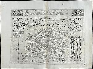
Map of Europe (Nova Totius Europae Tabula)
Edité par Antwerp, 1593
Vendeur : Trillium Antique Prints & Rare Books, Franklin, TN, Etats-Unis
Evaluation du vendeur :
Art / Affiche / Gravure
Etat : Fine. This map of Europe is entitled Nova Totius Europae Tabula ex magnis Gerardi de Iudaeris P. Desumpta . . . MDCXIII. The map was only issued in the second edition of the work. It shows several Northeast Passages and many mythical islands of the Atlantic (S. Brandain [Saint Brendan], Bresil [Brazil], Frislandt [Frisland]). It has an inset of costumed figures representing European culture. It shows Iceland and the Azores, and notes the English discovery of Nova Zemlya. It also has a note indicating a large mountain with pygmy natives it refers to as a Holy Land.Description of the work:This truly significant map is from one of the rarest atlases ever published, Gerard and Cornelis de Jode's Speculum orbis Terrae. The work was published in Antwerp in 1593 by Arnold Coninx for the widow and heirs. This is considered the second edition, revised an expanded. The first edition was published in 1578. Van Ortroy knew of only 14 copies of the second edition being published. (Skelton, Introduction to the facsimile editions)De Jode drew upon his large stock of maps from Italian, German, and Flemish cartographers to create his atlas. He engraved some of the maps and his brothers, Joannes and Lucas van Deutecum, also contributed to the process. The second edition included additional maps from Gerard's son Cornelis. The maps have descriptive text to verso in Latin. The text for the first edition was written by the German scholar, Daniel Cellarius.The atlas contained some of the most groundbreaking maps ever published. The maps of the world, Americas, Australia, and China are of particular note and remain some of the most important maps ever published. While it may not have had commercial success at the time, it is considered a masterpiece of 16th century cartography. Very few examples of the maps have survived from either edition.Gerard de Jode (1521- 1591) was a Flemish cartographer, printer, and engraver. He produced and sold many maps in Antwerp, but his legacy lies in his outstanding atlas, Speculum Orbis Terrarum. De Jode was a contemporary and competitor of Abraham Ortelius. Ortelius was believed to have been responsible for delaying de Jode's work so his atlas Theatrum Orbis Terrarum would precede de Jode's. Because Ortelius's atlas had 8 years on the market it was well established and thus de Jode's atlas did not sell very well.To compete with Ortelius, de Jode worked on the second revised and expanded edition. De Jode's wife and son, Cornelis (1568-1600) took over the publishing upon Gerard's death in 1591. Cornelis prepared ten new maps of the World, North America, China, Australia and Alaska and re-issued the atlas. "Many of de Jodeâ s maps are judged to be superior to those of Ortelius, both in detail and style." (Burden)Antwerp publisher Joan Baptista Vrients purchased the plates after Cornelis's death. He also acquired Ortelius's plates for Theatrum Orbis Terrarum to which he gave priority. It is likely he bought de Jode's plates to prevent any further editions of Speculum of course only increasing the intrigue and worth of the maps today."Although the atlas may not have appealed to the public, it was admired by other cartographers. As evidence, Petrus Montanus mentions it in the same breath with Mercatorâ s Atlas and Orteliusâ Theatrum in his preface to Pieter Kaeriusâ Germaniae inferior (Wardington Catalogue), Michael von Aitzing refers to it in his work, DeLeone Belgico (1583). Von Aitzing intended his work to act also as a supplement to both the Theatrum of Ortelius and the Speculum of De Jode." (Burden)Provenance : Ownership inscription at the bottom of the title page ex Bibliotheca Prim d Federici 1600.References: Van der Krogt 32:02B (titles 32:2A and 32:2B) ; Koeman II, Jod 2 ; Shirley, The mapping of the world, 165,184 ; Burden, The mapping of America, 81, 82 ; Symour, L. Schwartz, Ehrenberg, The mapping of America, pp. 78-79 ; Norwich, Maps of Africa 19 ; Navari, Maps of Cyprus, 29 ; Tooley, Dictionnary.
-
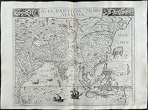
Map of Asia (Asia, Partium Orbis Maxima)
Edité par Antwerp, 1593
Vendeur : Trillium Antique Prints & Rare Books, Franklin, TN, Etats-Unis
Evaluation du vendeur :
Art / Affiche / Gravure
Etat : Fine. This map of Asia entitled Asia, Partium Orbis Maxima is noted for the first appearance of Formosa on a printed map. The map has irregular mapping of the Philippines and Japan. Korea is absent from the map. The Great Wall of China is illustrated along the northern border.Description of the work:This truly significant map is from one of the rarest atlases ever published, Gerard and Cornelis de Jode's Speculum orbis Terrae. The work was published in Antwerp in 1593 by Arnold Coninx for the widow and heirs. This is considered the second edition, revised an expanded. The first edition was published in 1578. Van Ortroy knew of only 14 copies of the second edition being published. (Skelton, Introduction to the facsimile editions)De Jode drew upon his large stock of maps from Italian, German, and Flemish cartographers to create his atlas. He engraved some of the maps and his brothers, Joannes and Lucas van Deutecum, also contributed to the process. The second edition included additional maps from Gerard's son Cornelis. The maps have descriptive text to verso in Latin. The text for the first edition was written by the German scholar, Daniel Cellarius.The atlas contained some of the most groundbreaking maps ever published. The maps of the world, Americas, Australia, and China are of particular note and remain some of the most important maps ever published. While it may not have had commercial success at the time, it is considered a masterpiece of 16th century cartography. Very few examples of the maps have survived from either edition.Gerard de Jode (1521- 1591) was a Flemish cartographer, printer, and engraver. He produced and sold many maps in Antwerp, but his legacy lies in his outstanding atlas, Speculum Orbis Terrarum. De Jode was a contemporary and competitor of Abraham Ortelius. Ortelius was believed to have been responsible for delaying de Jode's work so his atlas Theatrum Orbis Terrarum would precede de Jode's. Because Ortelius's atlas had 8 years on the market it was well established and thus de Jode's atlas did not sell very well.To compete with Ortelius, de Jode worked on the second revised and expanded edition. De Jode's wife and son, Cornelis (1568-1600) took over the publishing upon Gerard's death in 1591. Cornelis prepared ten new maps of the World, North America, China, Australia and Alaska and re-issued the atlas. "Many of de Jodeâ s maps are judged to be superior to those of Ortelius, both in detail and style." (Burden)Antwerp publisher Joan Baptista Vrients purchased the plates after Cornelis's death. He also acquired Ortelius's plates for Theatrum Orbis Terrarum to which he gave priority. It is likely he bought de Jode's plates to prevent any further editions of Speculum of course only increasing the intrigue and worth of the maps today."Although the atlas may not have appealed to the public, it was admired by other cartographers. As evidence, Petrus Montanus mentions it in the same breath with Mercatorâ s Atlas and Orteliusâ Theatrum in his preface to Pieter Kaeriusâ Germaniae inferior (Wardington Catalogue), Michael von Aitzing refers to it in his work, DeLeone Belgico (1583). Von Aitzing intended his work to act also as a supplement to both the Theatrum of Ortelius and the Speculum of De Jode." (Burden)Provenance : Ownership inscription at the bottom of the title page ex Bibliotheca Prim d Federici 1600.References: Van der Krogt 32:02B (titles 32:2A and 32:2B) ; Koeman II, Jod 2 ; Shirley, The mapping of the world, 165,184 ; Burden, The mapping of America, 81, 82 ; Symour, L. Schwartz, Ehrenberg, The mapping of America, pp. 78-79 ; Norwich, Maps of Africa 19 ; Navari, Maps of Cyprus, 29 ; Tooley, Dictionnary of mapmakers II, p. 441 ; Tooley, Mapping of Australia,; Tooley, Arabia in early maps, 38 (1st ed.) ; Koeman, Schilder, van Egmond, van der Krogt, HOC,vol. 3 part 2, Commercial Cartography and Map Production in the Low Countries, 1500 â " ca. 1672, pp. 1321-1323 ; Ortroy, Fern van, Lâ .
-
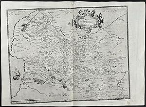
Map of the Artois Region between France and Belgium (Artois Atrebatum regionis vera descriptioâ ¦)
Edité par Antwerp, 1593
Vendeur : Trillium Antique Prints & Rare Books, Franklin, TN, Etats-Unis
Evaluation du vendeur :
Art / Affiche / Gravure
Etat : Fine. This is one of the most rare maps from De Jode. It was based upon the draft of Jacques de Surhon, a Flemish cartographer and silversmith. It was never actually published in the atlas, making it one of the hardest to find De Jode maps of the period.Description of the work:This truly significant map is from one of the rarest atlases ever published, Gerard and Cornelis de Jode's Speculum orbis Terrae. The work was published in Antwerp in 1593 by Arnold Coninx for the widow and heirs. This is considered the second edition, revised an expanded. The first edition was published in 1578. Van Ortroy knew of only 14 copies of the second edition being published. (Skelton, Introduction to the facsimile editions)De Jode drew upon his large stock of maps from Italian, German, and Flemish cartographers to create his atlas. He engraved some of the maps and his brothers, Joannes and Lucas van Deutecum, also contributed to the process. The second edition included additional maps from Gerard's son Cornelis. The maps have descriptive text to verso in Latin. The text for the first edition was written by the German scholar, Daniel Cellarius.The atlas contained some of the most groundbreaking maps ever published. The maps of the world, Americas, Australia, and China are of particular note and remain some of the most important maps ever published. While it may not have had commercial success at the time, it is considered a masterpiece of 16th century cartography. Very few examples of the maps have survived from either edition.Gerard de Jode (1521- 1591) was a Flemish cartographer, printer, and engraver. He produced and sold many maps in Antwerp, but his legacy lies in his outstanding atlas, Speculum Orbis Terrarum. De Jode was a contemporary and competitor of Abraham Ortelius. Ortelius was believed to have been responsible for delaying de Jode's work so his atlas Theatrum Orbis Terrarum would precede de Jode's. Because Ortelius's atlas had 8 years on the market it was well established and thus de Jode's atlas did not sell very well.To compete with Ortelius, de Jode worked on the second revised and expanded edition. De Jode's wife and son, Cornelis (1568-1600) took over the publishing upon Gerard's death in 1591. Cornelis prepared ten new maps of the World, North America, China, Australia and Alaska and re-issued the atlas. "Many of de Jodeâ s maps are judged to be superior to those of Ortelius, both in detail and style." (Burden)Antwerp publisher Joan Baptista Vrients purchased the plates after Cornelis's death. He also acquired Ortelius's plates for Theatrum Orbis Terrarum to which he gave priority. It is likely he bought de Jode's plates to prevent any further editions of Speculum of course only increasing the intrigue and worth of the maps today."Although the atlas may not have appealed to the public, it was admired by other cartographers. As evidence, Petrus Montanus mentions it in the same breath with Mercatorâ s Atlas and Orteliusâ Theatrum in his preface to Pieter Kaeriusâ Germaniae inferior (Wardington Catalogue), Michael von Aitzing refers to it in his work, DeLeone Belgico (1583). Von Aitzing intended his work to act also as a supplement to both the Theatrum of Ortelius and the Speculum of De Jode." (Burden)Provenance : Ownership inscription at the bottom of the title page ex Bibliotheca Prim d Federici 1600.References: Van der Krogt 32:02B (titles 32:2A and 32:2B) ; Koeman II, Jod 2 ; Shirley, The mapping of the world, 165,184 ; Burden, The mapping of America, 81, 82 ; Symour, L. Schwartz, Ehrenberg, The mapping of America, pp. 78-79 ; Norwich, Maps of Africa 19 ; Navari, Maps of Cyprus, 29 ; Tooley, Dictionnary of mapmakers II, p. 441 ; Tooley, Mapping of Australia,; Tooley, Arabia in early maps, 38 (1st ed.) ; Koeman, Schilder, van Egmond, van der Krogt, HOC,vol. 3 part 2, Commercial Cartography and Map Production in the Low Countries, 1500 â " ca. 1672, pp. 1321-1323 ; Ortroy, Fern van, Lâ oeuvre cartographique de Gerard et de Corneille de Jode, Gand 1914, 82-121. --- The work is in very good to excellent condition overall. The maps from this work are truly in remarkable condition for the age. While some faint offset or minor marks or imperfections can be expected, they generally present quite well. Most of the maps have been re-inforced with period paper archivally at the back of the fold, please review the image of the back. This is a general statement of the maps overall from the collection, we will try to note anything more significant, but please review the images and reach out with any questions or concerns. Please also note that occasionally the camera will create a blue or brown affect from the engraved lines and lighting effect, typically there is no coloration or defect but please ask if I can provide additional images. The listing is for only the map shown. --- Paper Size ~ 21 1/4" by 16".
-
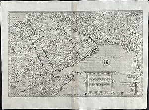
Map of the Arabian Peninsula & Sea Region (Secundae Partis Asiae)
Edité par Antwerp, 1593
Vendeur : Trillium Antique Prints & Rare Books, Franklin, TN, Etats-Unis
Evaluation du vendeur :
Art / Affiche / Gravure
Etat : Fine. This is one of the earliest obtainable maps of Arabia entitled Secundae Partis Asiae is focused on the Middle East. It is based on Giacomo Gastaldi's map of 1561. Gerard de Jode prepared the map for the first edition of Speculum.Description of the work:This truly significant map is from one of the rarest atlases ever published, Gerard and Cornelis de Jode's Speculum orbis Terrae. The work was published in Antwerp in 1593 by Arnold Coninx for the widow and heirs. This is considered the second edition, revised an expanded. The first edition was published in 1578. Van Ortroy knew of only 14 copies of the second edition being published. (Skelton, Introduction to the facsimile editions)De Jode drew upon his large stock of maps from Italian, German, and Flemish cartographers to create his atlas. He engraved some of the maps and his brothers, Joannes and Lucas van Deutecum, also contributed to the process. The second edition included additional maps from Gerard's son Cornelis. The maps have descriptive text to verso in Latin. The text for the first edition was written by the German scholar, Daniel Cellarius.The atlas contained some of the most groundbreaking maps ever published. The maps of the world, Americas, Australia, and China are of particular note and remain some of the most important maps ever published. While it may not have had commercial success at the time, it is considered a masterpiece of 16th century cartography. Very few examples of the maps have survived from either edition.Gerard de Jode (1521- 1591) was a Flemish cartographer, printer, and engraver. He produced and sold many maps in Antwerp, but his legacy lies in his outstanding atlas, Speculum Orbis Terrarum. De Jode was a contemporary and competitor of Abraham Ortelius. Ortelius was believed to have been responsible for delaying de Jode's work so his atlas Theatrum Orbis Terrarum would precede de Jode's. Because Ortelius's atlas had 8 years on the market it was well established and thus de Jode's atlas did not sell very well.To compete with Ortelius, de Jode worked on the second revised and expanded edition. De Jode's wife and son, Cornelis (1568-1600) took over the publishing upon Gerard's death in 1591. Cornelis prepared ten new maps of the World, North America, China, Australia and Alaska and re-issued the atlas. "Many of de Jodeâ s maps are judged to be superior to those of Ortelius, both in detail and style." (Burden)Antwerp publisher Joan Baptista Vrients purchased the plates after Cornelis's death. He also acquired Ortelius's plates for Theatrum Orbis Terrarum to which he gave priority. It is likely he bought de Jode's plates to prevent any further editions of Speculum of course only increasing the intrigue and worth of the maps today."Although the atlas may not have appealed to the public, it was admired by other cartographers. As evidence, Petrus Montanus mentions it in the same breath with Mercatorâ s Atlas and Orteliusâ Theatrum in his preface to Pieter Kaeriusâ Germaniae inferior (Wardington Catalogue), Michael von Aitzing refers to it in his work, DeLeone Belgico (1583). Von Aitzing intended his work to act also as a supplement to both the Theatrum of Ortelius and the Speculum of De Jode." (Burden)Provenance : Ownership inscription at the bottom of the title page ex Bibliotheca Prim d Federici 1600.References: Van der Krogt 32:02B (titles 32:2A and 32:2B) ; Koeman II, Jod 2 ; Shirley, The mapping of the world, 165,184 ; Burden, The mapping of America, 81, 82 ; Symour, L. Schwartz, Ehrenberg, The mapping of America, pp. 78-79 ; Norwich, Maps of Africa 19 ; Navari, Maps of Cyprus, 29 ; Tooley, Dictionnary of mapmakers II, p. 441 ; Tooley, Mapping of Australia,; Tooley, Arabia in early maps, 38 (1st ed.) ; Koeman, Schilder, van Egmond, van der Krogt, HOC,vol. 3 part 2, Commercial Cartography and Map Production in the Low Countries, 1500 â " ca. 1672, pp. 1321-1323 ; Ortroy, Fern van, Lâ oeuvre cartographique de Gerard et de Corn.
-
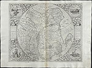
Map of China (China Regnum)
Edité par Antwerp, 1593
Vendeur : Trillium Antique Prints & Rare Books, Franklin, TN, Etats-Unis
Evaluation du vendeur :
Art / Affiche / Gravure
Etat : Fine. This map is one of the most rare and sought after maps of China entitled China Regnum. It was the first de Jode map of China. It mapped China, part of Japan, Korea, Taiwan, and northern Philippines. It was based on the work of Jorge de Barbuda, a Portuguese cartographer, whose map appeared in Ortelius's 1584 publication of Theatrum. It was the second map of China to be printed in Europe.Description of the work:This truly significant map is from one of the rarest atlases ever published, Gerard and Cornelis de Jode's Speculum orbis Terrae. The work was published in Antwerp in 1593 by Arnold Coninx for the widow and heirs. This is considered the second edition, revised an expanded. The first edition was published in 1578. Van Ortroy knew of only 14 copies of the second edition being published. (Skelton, Introduction to the facsimile editions)De Jode drew upon his large stock of maps from Italian, German, and Flemish cartographers to create his atlas. He engraved some of the maps and his brothers, Joannes and Lucas van Deutecum, also contributed to the process. The second edition included additional maps from Gerard's son Cornelis. The maps have descriptive text to verso in Latin. The text for the first edition was written by the German scholar, Daniel Cellarius.The atlas contained some of the most groundbreaking maps ever published. The maps of the world, Americas, Australia, and China are of particular note and remain some of the most important maps ever published. While it may not have had commercial success at the time, it is considered a masterpiece of 16th century cartography. Very few examples of the maps have survived from either edition.Gerard de Jode (1521- 1591) was a Flemish cartographer, printer, and engraver. He produced and sold many maps in Antwerp, but his legacy lies in his outstanding atlas, Speculum Orbis Terrarum. De Jode was a contemporary and competitor of Abraham Ortelius. Ortelius was believed to have been responsible for delaying de Jode's work so his atlas Theatrum Orbis Terrarum would precede de Jode's. Because Ortelius's atlas had 8 years on the market it was well established and thus de Jode's atlas did not sell very well.To compete with Ortelius, de Jode worked on the second revised and expanded edition. De Jode's wife and son, Cornelis (1568-1600) took over the publishing upon Gerard's death in 1591. Cornelis prepared ten new maps of the World, North America, China, Australia and Alaska and re-issued the atlas. "Many of de Jodeâ s maps are judged to be superior to those of Ortelius, both in detail and style." (Burden)Antwerp publisher Joan Baptista Vrients purchased the plates after Cornelis's death. He also acquired Ortelius's plates for Theatrum Orbis Terrarum to which he gave priority. It is likely he bought de Jode's plates to prevent any further editions of Speculum of course only increasing the intrigue and worth of the maps today."Although the atlas may not have appealed to the public, it was admired by other cartographers. As evidence, Petrus Montanus mentions it in the same breath with Mercatorâ s Atlas and Orteliusâ Theatrum in his preface to Pieter Kaeriusâ Germaniae inferior (Wardington Catalogue), Michael von Aitzing refers to it in his work, DeLeone Belgico (1583). Von Aitzing intended his work to act also as a supplement to both the Theatrum of Ortelius and the Speculum of De Jode." (Burden)Provenance : Ownership inscription at the bottom of the title page ex Bibliotheca Prim d Federici 1600.References: Van der Krogt 32:02B (titles 32:2A and 32:2B) ; Koeman II, Jod 2 ; Shirley, The mapping of the world, 165,184 ; Burden, The mapping of America, 81, 82 ; Symour, L. Schwartz, Ehrenberg, The mapping of America, pp. 78-79 ; Norwich, Maps of Africa 19 ; Navari, Maps of Cyprus, 29 ; Tooley, Dictionnary of mapmakers II, p. 441 ; Tooley, Mapping of Australia,; Tooley, Arabia in early maps, 38 (1st ed.) ; Koeman, Schilder, van Egmond, van der Krogt, HOC,vol. 3 part 2, Commerc.
-
Map of the World on Marinus of Tyre's Projection (Totius Orbis Cogniti Universalis Descriptio)
Edité par Antwerp, 1593
Vendeur : Trillium Antique Prints & Rare Books, Franklin, TN, Etats-Unis
Evaluation du vendeur :
Art / Affiche / Gravure
Etat : Fine. This world map entitled Totius Orbis Cogniti Universalis Descriptio was produced by Cornelis de Jode in 1589 at the Academy of Douai. It is on the rectangular projection typically credited to Marinus of Tyre. It also features two smaller maps of the eastern and western hemispheres in the corners based on Roger Bacon's circular projection. (Shirley 165)Description of the work:This truly significant map is from one of the rarest atlases ever published, Gerard and Cornelis de Jode's Speculum orbis Terrae. The work was published in Antwerp in 1593 by Arnold Coninx for the widow and heirs. This is considered the second edition, revised an expanded. The first edition was published in 1578. Van Ortroy knew of only 14 copies of the second edition being published. (Skelton, Introduction to the facsimile editions)De Jode drew upon his large stock of maps from Italian, German, and Flemish cartographers to create his atlas. He engraved some of the maps and his brothers, Joannes and Lucas van Deutecum, also contributed to the process. The second edition included additional maps from Gerard's son Cornelis. The maps have descriptive text to verso in Latin. The text for the first edition was written by the German scholar, Daniel Cellarius.The atlas contained some of the most groundbreaking maps ever published. The maps of the world, Americas, Australia, and China are of particular note and remain some of the most important maps ever published. While it may not have had commercial success at the time, it is considered a masterpiece of 16th century cartography. Very few examples of the maps have survived from either edition.Gerard de Jode (1521- 1591) was a Flemish cartographer, printer, and engraver. He produced and sold many maps in Antwerp, but his legacy lies in his outstanding atlas, Speculum Orbis Terrarum. De Jode was a contemporary and competitor of Abraham Ortelius. Ortelius was believed to have been responsible for delaying de Jode's work so his atlas Theatrum Orbis Terrarum would precede de Jode's. Because Ortelius's atlas had 8 years on the market it was well established and thus de Jode's atlas did not sell very well.To compete with Ortelius, de Jode worked on the second revised and expanded edition. De Jode's wife and son, Cornelis (1568-1600) took over the publishing upon Gerard's death in 1591. Cornelis prepared ten new maps of the World, North America, China, Australia and Alaska and re-issued the atlas. "Many of de Jodeâ s maps are judged to be superior to those of Ortelius, both in detail and style." (Burden)Antwerp publisher Joan Baptista Vrients purchased the plates after Cornelis's death. He also acquired Ortelius's plates for Theatrum Orbis Terrarum to which he gave priority. It is likely he bought de Jode's plates to prevent any further editions of Speculum of course only increasing the intrigue and worth of the maps today."Although the atlas may not have appealed to the public, it was admired by other cartographers. As evidence, Petrus Montanus mentions it in the same breath with Mercatorâ s Atlas and Orteliusâ Theatrum in his preface to Pieter Kaeriusâ Germaniae inferior (Wardington Catalogue), Michael von Aitzing refers to it in his work, DeLeone Belgico (1583). Von Aitzing intended his work to act also as a supplement to both the Theatrum of Ortelius and the Speculum of De Jode." (Burden)Provenance : Ownership inscription at the bottom of the title page ex Bibliotheca Prim d Federici 1600.References: Van der Krogt 32:02B (titles 32:2A and 32:2B) ; Koeman II, Jod 2 ; Shirley, The mapping of the world, 165,184 ; Burden, The mapping of America, 81, 82 ; Symour, L. Schwartz, Ehrenberg, The mapping of America, pp. 78-79 ; Norwich, Maps of Africa 19 ; Navari, Maps of Cyprus, 29 ; Tooley, Dictionnary of mapmakers II, p. 441 ; Tooley, Mapping of Australia,; Tooley, Arabia in early maps, 38 (1st ed.) ; Koeman, Schilder, van Egmond, van der Krogt, HOC,vol. 3 part 2, Commercial Cartography and Map Production i.
-

Map of America (Americae Pars Borealis, Florida, Baccalaos, Canada, Corterealis . . .)
Edité par Antwerp, 1593
Vendeur : Trillium Antique Prints & Rare Books, Franklin, TN, Etats-Unis
Evaluation du vendeur :
Art / Affiche / Gravure
Etat : Fine. This map of America entitled Americae pars Borealis is based upon the eighteen sheet world map of 1592 by Petrus Plancius to create the outline of America. It was the second printed map to encompass this area, the first being Forlani's map from 1565. This is the first state of the map with the name LaudonniĂ re in the legend above the Arctic Circle. (Burden 81-82) It is the first map of North America printed in a commercial atlas.Description of the work:This truly significant map is from one of the rarest atlases ever published, Gerard and Cornelis de Jode's Speculum orbis Terrae. The work was published in Antwerp in 1593 by Arnold Coninx for the widow and heirs. This is considered the second edition, revised an expanded. The first edition was published in 1578. Van Ortroy knew of only 14 copies of the second edition being published. (Skelton, Introduction to the facsimile editions)De Jode drew upon his large stock of maps from Italian, German, and Flemish cartographers to create his atlas. He engraved some of the maps and his brothers, Joannes and Lucas van Deutecum, also contributed to the process. The second edition included additional maps from Gerard's son Cornelis. The maps have descriptive text to verso in Latin. The text for the first edition was written by the German scholar, Daniel Cellarius.The atlas contained some of the most groundbreaking maps ever published. The maps of the world, Americas, Australia, and China are of particular note and remain some of the most important maps ever published. While it may not have had commercial success at the time, it is considered a masterpiece of 16th century cartography. Very few examples of the maps have survived from either edition.Gerard de Jode (1521- 1591) was a Flemish cartographer, printer, and engraver. He produced and sold many maps in Antwerp, but his legacy lies in his outstanding atlas, Speculum Orbis Terrarum. De Jode was a contemporary and competitor of Abraham Ortelius. Ortelius was believed to have been responsible for delaying de Jode's work so his atlas Theatrum Orbis Terrarum would precede de Jode's. Because Ortelius's atlas had 8 years on the market it was well established and thus de Jode's atlas did not sell very well.To compete with Ortelius, de Jode worked on the second revised and expanded edition. De Jode's wife and son, Cornelis (1568-1600) took over the publishing upon Gerard's death in 1591. Cornelis prepared ten new maps of the World, North America, China, Australia and Alaska and re-issued the atlas. "Many of de Jodeâ s maps are judged to be superior to those of Ortelius, both in detail and style." (Burden)Antwerp publisher Joan Baptista Vrients purchased the plates after Cornelis's death. He also acquired Ortelius's plates for Theatrum Orbis Terrarum to which he gave priority. It is likely he bought de Jode's plates to prevent any further editions of Speculum of course only increasing the intrigue and worth of the maps today."Although the atlas may not have appealed to the public, it was admired by other cartographers. As evidence, Petrus Montanus mentions it in the same breath with Mercatorâ s Atlas and Orteliusâ Theatrum in his preface to Pieter Kaeriusâ Germaniae inferior (Wardington Catalogue), Michael von Aitzing refers to it in his work, DeLeone Belgico (1583). Von Aitzing intended his work to act also as a supplement to both the Theatrum of Ortelius and the Speculum of De Jode." (Burden)Provenance : Ownership inscription at the bottom of the title page ex Bibliotheca Prim d Federici 1600.References: Van der Krogt 32:02B (titles 32:2A and 32:2B) ; Koeman II, Jod 2 ; Shirley, The mapping of the world, 165,184 ; Burden, The mapping of America, 81, 82 ; Symour, L. Schwartz, Ehrenberg, The mapping of America, pp. 78-79 ; Norwich, Maps of Africa 19 ; Navari, Maps of Cyprus, 29 ; Tooley, Dictionnary of mapmakers II, p. 441 ; Tooley, Mapping of Australia,; Tooley, Arabia in early maps, 38 (1st ed.) ; Koeman, Schilder, van Egmo.